September 18, 2023
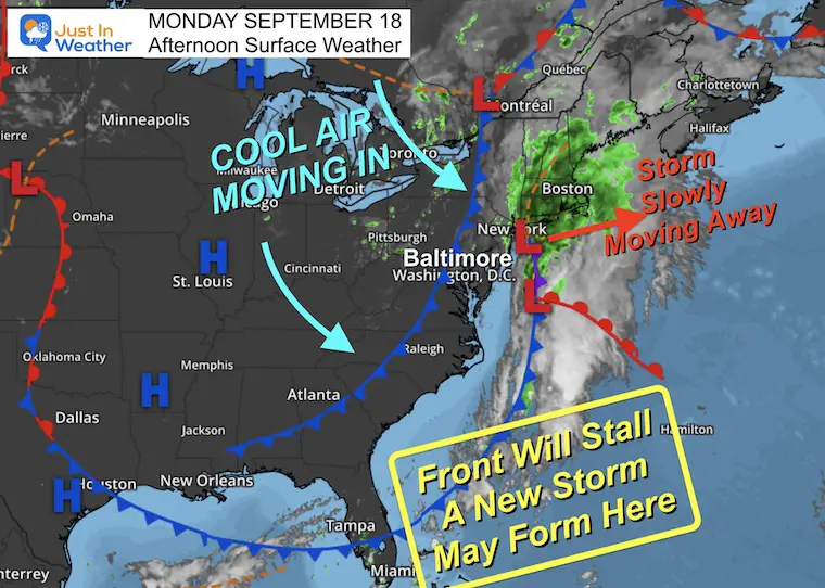
Monday Afternoon Update
It may be hard to believe that just one week ago, we were in the grip of a record breaking late season heat wave. Now that we are back into more seasonable weather and moving the latest rain off the coast, the fast changes may have something else in store.
At this time of year, a cold front can push south and bring us nice weather with low humidity. But that front can also stall across the Southeast US. With the contrast of cool air to the north and warm water in the Gulf Stream, a circulation can develop into a new storm.
Considering the three named storms in this region over the last three weeks, this area is primed for something to at least ‘try’ to develop.
Monday Afternoon Set Up
This is what may happen in the week ahead. The cold front that brought us rain last night and this morning is stalling out. We will get a few nice days, but the water off the Southeast US coast is what we need to watch.
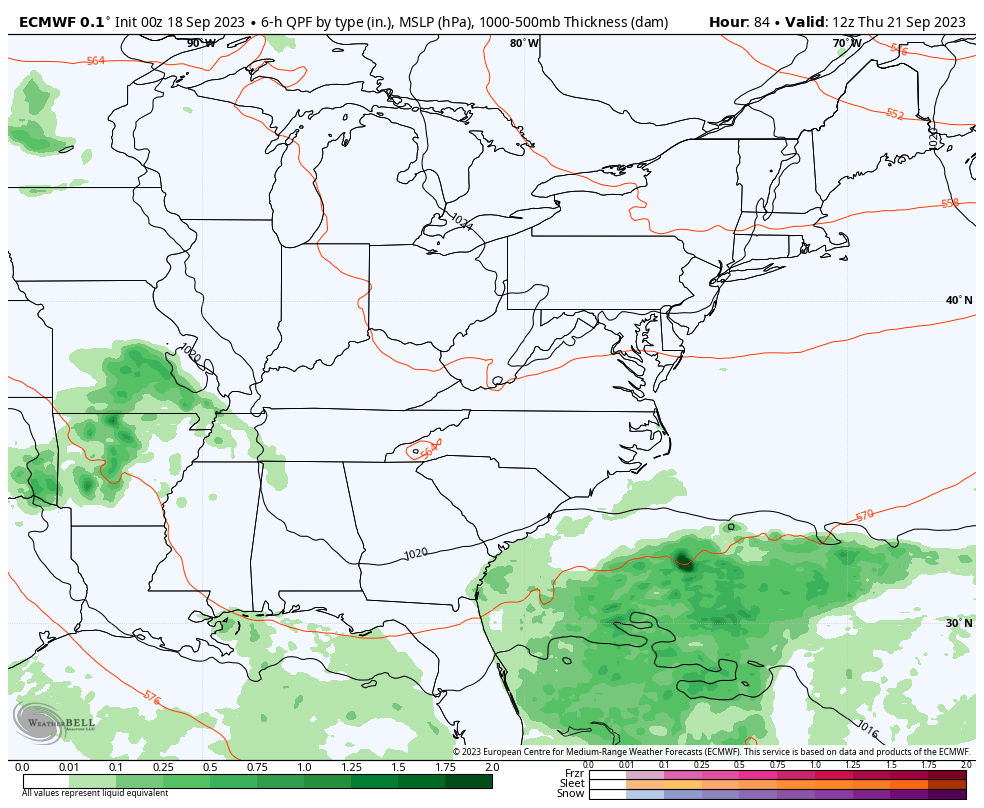
Note: I continue to be very cautious of computer model guidance. We are looking 5 days into the future, and I have not had much confidence in the products this year. However, the model forecasts I am showing below do have historical support. There is a good chance that something will develop, but not exactly what we see here. I am sharing this with you so we can compare any trends to support or shift expectations.
Forecast Animation: Thursday to Monday
The European ECMWF Model is showing this region generating rain later this week. This new Low Pressure will begin to move north and bring moderate to heavy rain into our region later Saturday into Sunday.
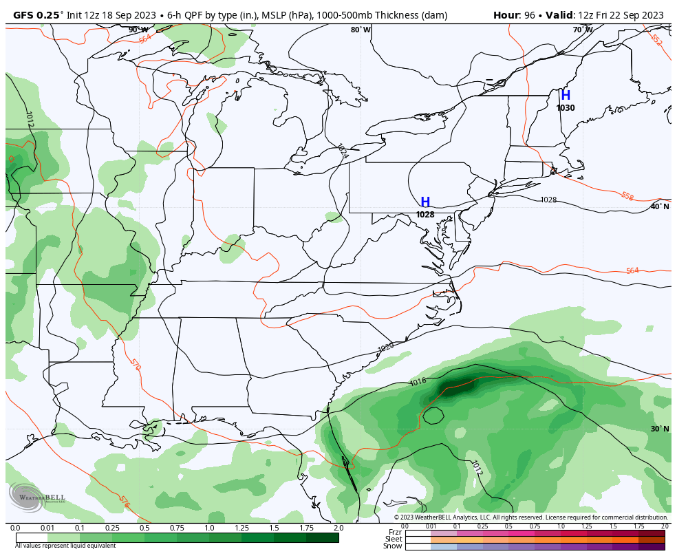
Compare To The GFS Model
Here is another solution from the American GFS Model that is a bit more robust. Below the animation is a deeper dive into how this may develop.
Animation: Friday Morning to Sunday Night
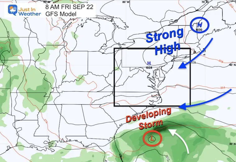
Friday Morning Set Up
High Pressure centered in New England will dominate into the Mid-Atlantic. This also sends a Northeast wind into the Carolinas.
Meanwhile, Low Pressure may start to spin off the Southeast US coast. That is the area of the stalled front.
This may or may not be a formal tropical cyclone. That will depend on whether this develops a pure warm core or has a cold side. Also, the wind speed would need to be over 39 mph to get a name.
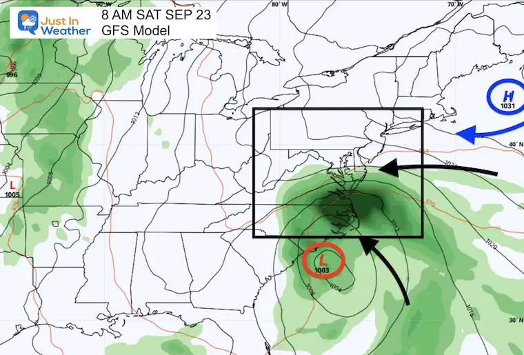
Saturday Morning Set-Up
Surface Weather
High-pressure slides off the coast of New England.
The new Low Pressure looks more organized and moves north into the South Carolina coast.
In between, a strong East Wind will increase the moisture across the Mid-Atlantic coast. Rain may expand into southern Maryland by daybreak.
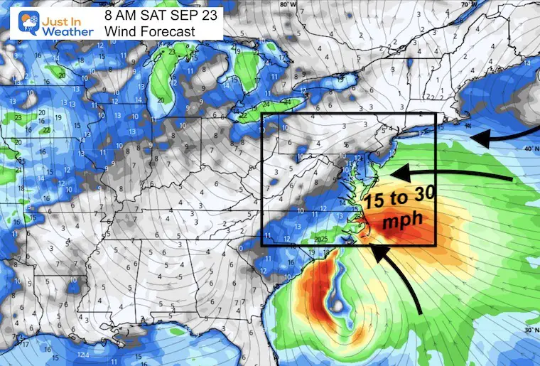
Morning Wind Forecast
This may help show the wind field. Surface winds may be up to 30 mph along the coast. 15 to 20 mph inland. It will be a cool and breezy day!
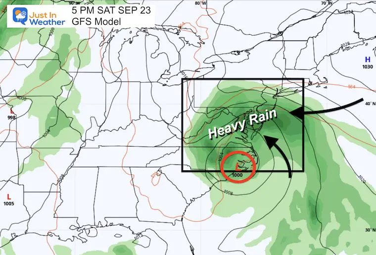
Afternoon Surface Weather
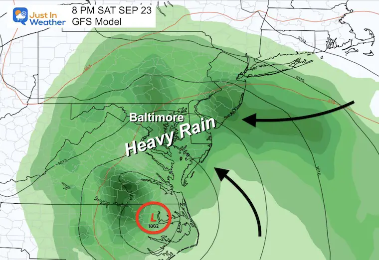
By late afternoon, the Surface Low may move up the North Carolina coast, expanding the rain and wind across the entire Mid-Atlantic.
*This is if this solution verifies*
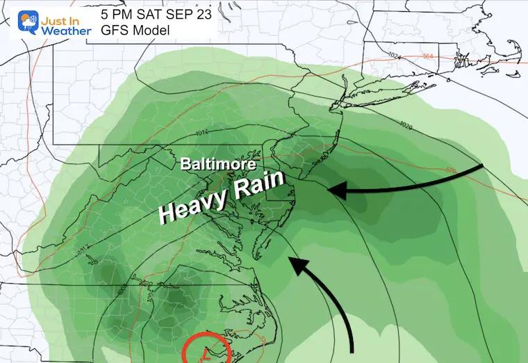
Closer Look: Mid-Atlantic
5 PM – A broad area of moderate to heavy rain may dominate the entire Mid-Atlantic seaboard.
8 PM – If this scenario plays out, it will be a very wet evening and Saturday night. This may affect your plans from sports, to parties, concerts, and camping.
Animation Saturday Evening To Sunday Evening
The rain is expected to be heaviest Saturday night, then lingering showers into Sunday.
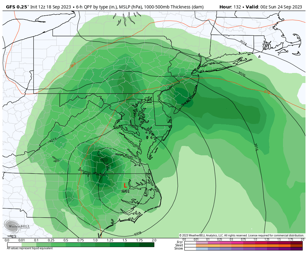
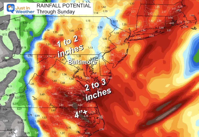
Potential Rainfall
The GFS Model we just explored above is showing a broad area of moderate to heavy rain. This would be beneficial to drought areas, but too much could lead to flooding. The heaviest rain appears to be in Southeast Virginia to North Carolina, with over 4 inches.
Much of our region may end up in the 1 to 3-inch range.
New Reports:
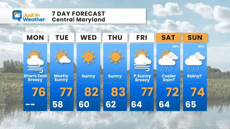
Extended Forecast
This is from my morning report. I did include the chance for rain, but it’s not a promise… yet.
7 Day Forecast
EXPLORE MORE
EARLIER IN AUGUST: Maryland Trek 10 For These Kids
I will have a follow-up and recap on our amazing week shortly.

Subscribe for eMail Alerts

Please share your thoughts and best weather pics/videos, or just keep in touch via social media
RESTATING MY MESSAGE ABOUT DYSLEXIA
I am aware there are some spelling and grammar typos and occasional other glitches. I take responsibility for my mistakes and even the computer glitches I may miss. I have made a few public statements over the years, but if you are new here, you may have missed it: I have dyslexia and found out during my second year at Cornell University. It didn’t stop me from getting my meteorology degree and being the first to get the AMS CBM in the Baltimore/Washington region. One of my professors told me that I had made it that far without knowing and to not let it be a crutch going forward. That was Mark Wysocki, and he was absolutely correct! I do miss my mistakes in my own proofreading. The autocorrect spell check on my computer sometimes does an injustice to make it worse. I also can make mistakes in forecasting. No one is perfect at predicting the future. All of the maps and information are accurate. The ‘wordy’ stuff can get sticky. There has been no editor who can check my work when I need it and have it ready to send out in a newsworthy timeline. Barbara Werner is a member of the web team that helps me maintain this site. She has taken it upon herself to edit typos when she is available. That could be AFTER you read this. I accept this and perhaps proves what you read is really from me… It’s part of my charm.
#FITF


