This month has brought a record heat wave and an early-season cool spell. The trees have been under stress from persistent drought and extreme conditions. So early leaf colors have been popping up, causing many to ask if this means anything for the winter ahead. Here is a look at one dominant factor that may bring us some insight.
An El Niño Advisory continues as we head into Fall and Winter.This is verifying the expectations for warm water in the tropical Pacific Ocean. This is the source region for a storm pattern that influences the track into North America and possibly our winter weather here on the East Coast of the United States.
This report has the latest seasonal outlook from NOAA. It is not their official winter outlook, but we have a look at what they might be thinking, and it is based on El Niño.
My forecast region is The Mid-Atlantic region, and I will be using the Baltimore records as a central reference point for additional historical data.
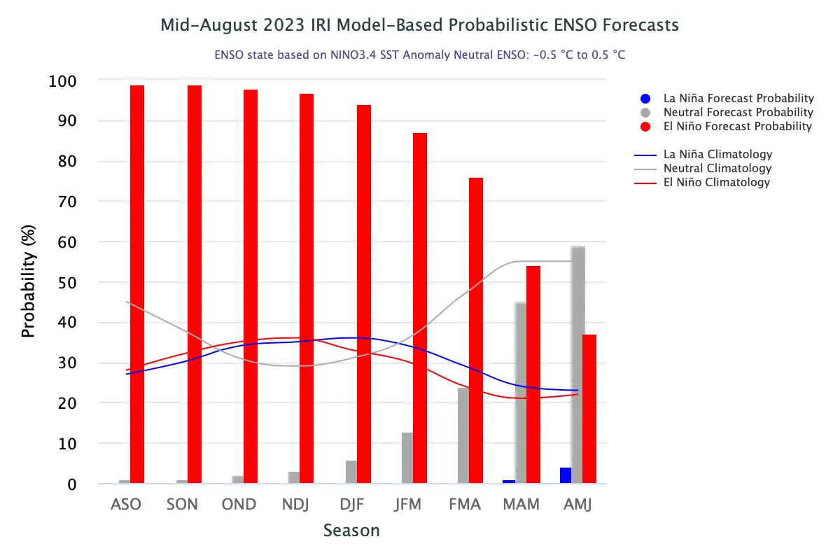
El Niño Likelihood
The International Research Institute(IRI) shows a 71% chance that a Strong El Niño will persist through the winter months: December, January, and February (DJF). There is a 95% chance El Niño of any strength will persist through March. It is important to note it may tend weaker or towards neutral later in Winter.
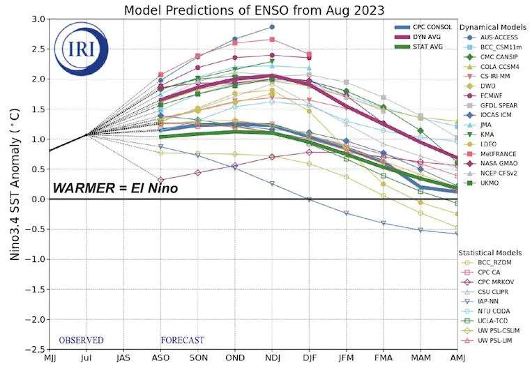
Another Model View
What is El Niño?
Before diving into what this may mean for our weather, let’s look at the weather phenomenon itself.
During normal conditions in the Pacific Ocean, trade winds blow west along the equator, taking warm water from South America towards Asia. To replace that warm water, cold water rises from the depths — a process called upwelling. El Niño and La Niña are two opposing climate patterns that break these normal conditions. Scientists call these phenomena the El Niño-Southern Oscillation (ENSO) cycle. El Niño and La Niña can both have global impacts on weather, wildfires, ecosystems, and economies. Episodes of El Niño and La Niña typically last nine to 12 months, but can sometimes last for years. El Niño and La Niña events occur every two to seven years, on average, but they don’t occur on a regular schedule. Generally, El Niño occurs more frequently than La Niña.
El Niño
During El Niño, trade winds weaken. Warm water is pushed back east toward the west coast of the Americas.
El Niño means Little Boy in Spanish. South American fishermen first noticed periods of unusually warm water in the Pacific Ocean in the 1600’s. The full name they used was El Niño de Navidad, because El Niño typically peaks around December.
NOAA Video
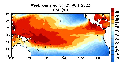
Latest Sea Surface Temperature
June Through September
Here, we can see the warm water building and expanding across the Pacific Ocean across the Equator.
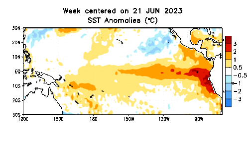
Sea Surface Temperature Anomalies
June Through September
This is more telling as this display shows how far above or below average the temperatures are reading.
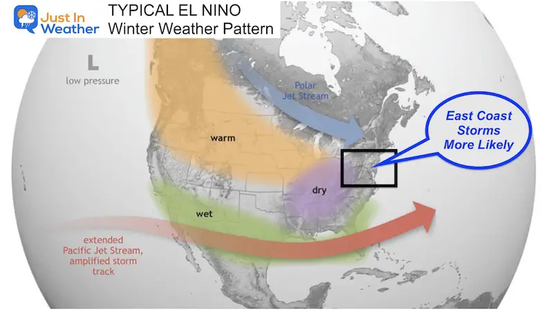
Impact On the Weather Pattern in the United States
The active jet stream gets pushed south and becomes more potent across the southern US and Gulf Coast.
This can do one of two things:
Strong southern storms which may have snow and ice if they can team up with colder air.
Either those storms can turn up the coast, bringing Nor’easters, or get pushed out to sea.
I’ve highlighted the Mid-Atlantic as we can be on the edge of the action.
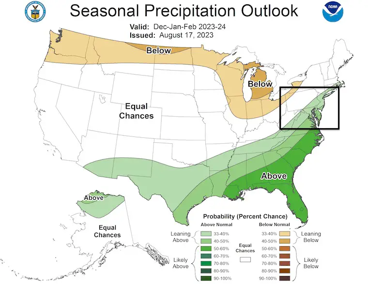
NOAA Winter Outlook For Precipitation
The green shade across the Southeast US and Mid-Atlantic Atlantic = Leaning Above Average. This can mean rain and or snow.
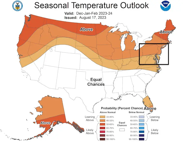
NOAA Winter Outlook For Temperatures
The orange shading is leaning warmer. This is in response to an expected zonal flow not allowing many arctic intrusions. It doesn’t mean we will not get any, just lowers the frequency or potency.
But we need to dig deeper to understand this more.
Historical Winters In Baltimore, MD
Again, this is central to the Mid-Atlantic region, so we can extrapolate this for your area as well across all of Maryland, Virginia, West Virginia, Delaware, and Pennsylvania.
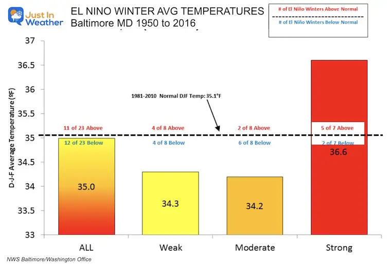
Comparing 23 El Niños between 1950 and 2016
Temperatures at BWI From The National Weather Service
Contrary to the map above, the average El Niño winter is slightly cooler than average. A Weak and Moderate El Niño tends to be colder.
If the El Niño is Strong, then the dominant Pacific Jet Stream tends to make winters quite warm.
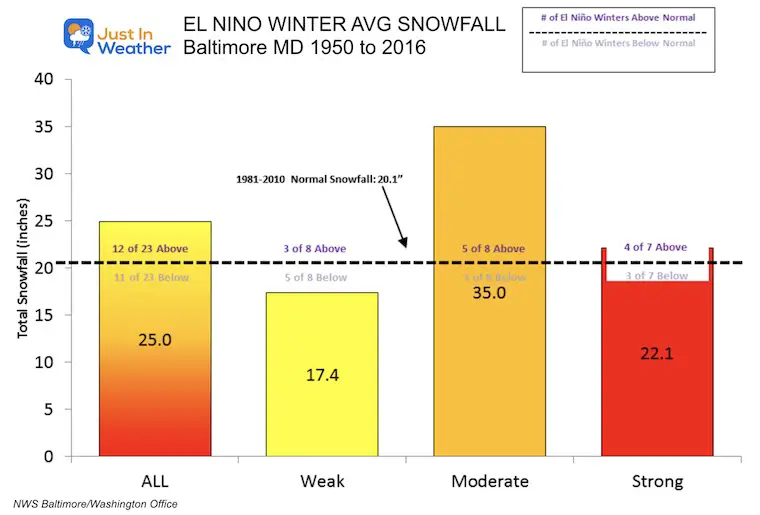
Snowfall
Measured at BWI From The National Weather Service
The average El Niño winter brings more snow. In this sample, 25% higher or 5 inches of additional snow. Then again, any snowfall will be more than last winter’s record 0.2”.
The sweet spot for big snowfall is with a Moderate El Niño. In the 8 winters that had an El Niño, 5 produced more snow, and the overall average was 35 inches or 75% above normal!
A Strong El Niño also has a tendency to produce above-average snowfall. Considering that this also can bring a warmer winter helps show that we can have cold storms in the middle of a warmer season.
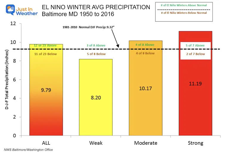
Total Precipitation
An average El Niño brings above-average precipitation. This is snow and rain combined, and it’s great news, considering the drought our region has been experiencing all year.
The strength of the El Niño will determine the storm activity. More can be expected with a Moderate and Strong El Niño.
My Take
If you have Faith in the Flakes and want snow, then a Moderate El Niño is what you may be hoping for.
The odds are 71% for a Strong El Niño from November through January. In this case, a weakening El Niño may actually help with more snowfall later in the season.
There is a 95% chance that El Niño conditions of any strength will last through March.
The NOAA official Winter Outlook is usually published in the third week of October.
This is just one of many factors that influence the winter weather pattern. I use a combination of global conditions and other historical references. I plan to have My Winter Outlook ready by the end of October or early November. I am leaning towards:
“We will get more snow because we can’t get less”.
I am aware there are some spelling and grammar typos and occasional other glitches. I take responsibility for my mistakes and even the computer glitches I may miss. I have made a few public statements over the years, but if you are new here, you may have missed it:I have dyslexia and found out during my second year at Cornell University. It didn’t stop me from getting my meteorology degree and being the first to get the AMS CBM in the Baltimore/Washington region. One of my professors told me that I had made it that far without knowing and to not let it be a crutch going forward. That was Mark Wysocki, and he was absolutely correct!I do miss my mistakes in my own proofreading. The autocorrect spell check on my computer sometimes does an injustice to make it worse. I also can make mistakes in forecasting. No one is perfect at predicting the future.All of the maps and information are accurate. The ‘wordy’ stuff can get sticky. There has been no editor who can check my work when I need it and have it ready to send out in a newsworthy timeline. Barbara Werner is a member of the web team that helps me maintain this site. She has taken it upon herself to edit typos when she is available. That could be AFTER you read this.I accept this and perhaps proves what you read is really from me…It’s part of my charm.