


April 28 Heating Up And Tornado Video From The Central US Storm Outbreak
Sunday April 28 Morning Report We start this day with thick fog and it might not seem like a change is on the way. A Dense Fog Advisory is in…
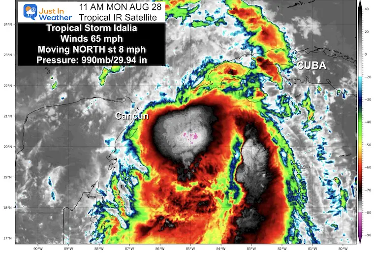
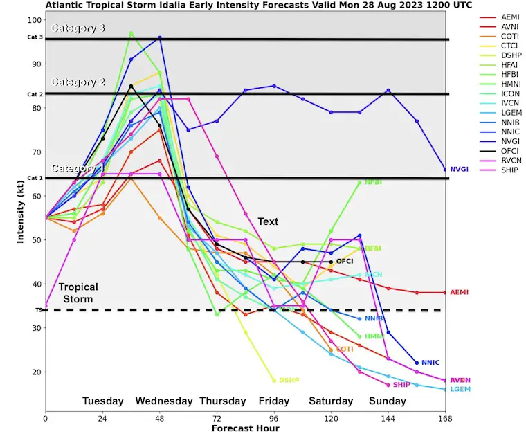
Monday, August 28 Mid Day Update
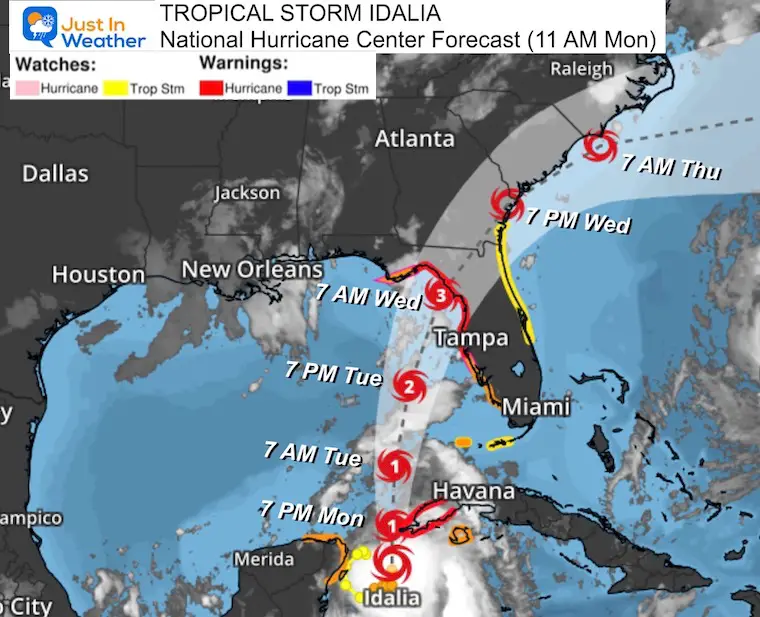
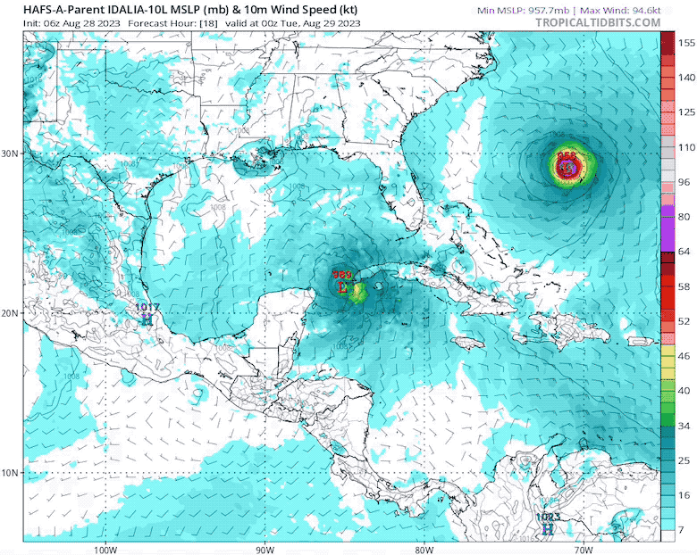
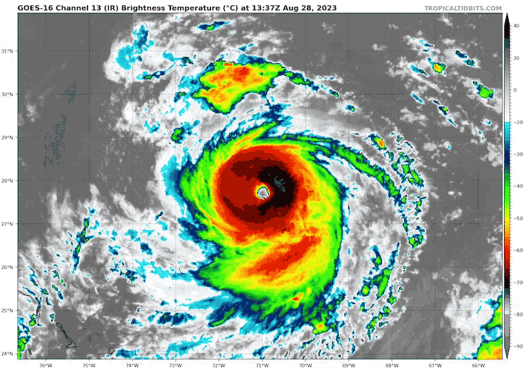
Idalia is still a strong tropical storm as of the 11 AM Monday advisory from The National Hurricane Center. It is expected to become a hurricane later today. Florida is taking this seriously, with the expected landfall this week as a major hurricane of Category 3 or higher.
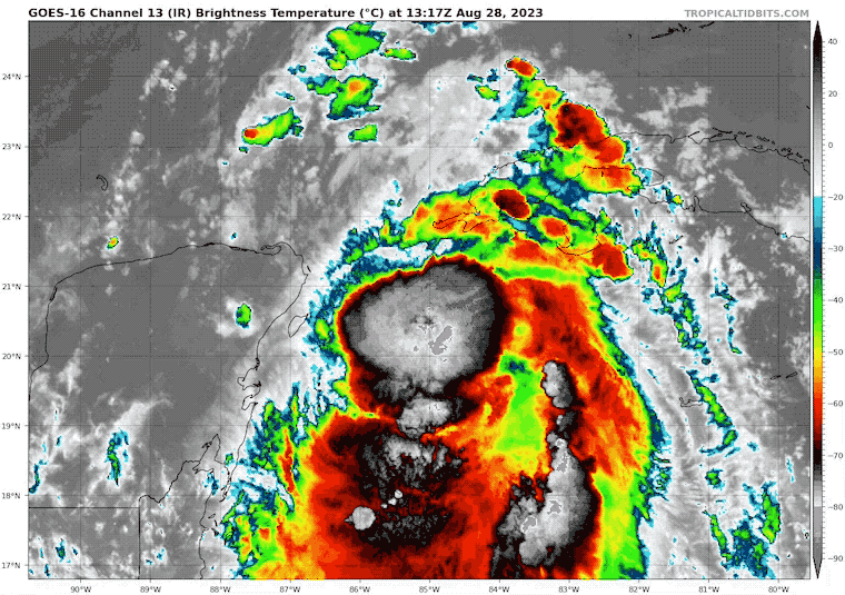
In this report below, you will find the latest update, satellite loop, forecast maps, and interactive Windy Widget. I have a brief update on Hurricane Franklin as well since it will be affecting water for similar areas on the Atlantic coast.
Florida’s Governor DeSantis has implemented or encouraged state and 46 county emergency management offices to be activated now.
According to DeSantis, Evacuation Orders will include Zones A and B. If they have not been announced yet, they will be for barrier islands and immediate coastal areas within the potential impact zone. They were highlighted in the press conference as North of Tampa to Tallahassee.
It is important to note that the heavy rain, tornadoes, and storm surge can affect a larger area than the immediate eye wall at landfall.
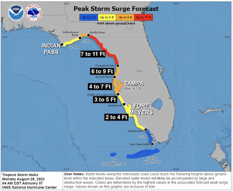
A Storm Surge Warning is in effect for…
* Englewood northward to the Ochlockonee River, including Tampa Bay
A Hurricane Warning is in effect for…
* Cuban province of Pinar del Rio
* Middle of Longboat Key northward to the Ochlockonee River, including Tampa Bay
A Tropical Storm Warning is in effect for…
* Yucatan Peninsula from Tulum to Rio Lagartos, including Cozumel
* Isle of Youth Cuba
* Dry Tortugas Florida
* Chokoloskee northward to the Middle of Longboat Key
* West of the Ochlockonee River westward to Indian Pass
A Storm Surge Watch is in effect for…
* Chokoloskee northward to Englewood, including Charlotte Harbour
* Ochlockonee River to Indian Pass, Florida
* Mouth of the St. Mary’s River to Altamaha Sound, Georgia
A Hurricane Watch is in effect for…
* Englewood to the Middle of Longboat Key
* West of the Ochlockonee River westward to Indian Pass
A Tropical Storm Warning is in effect for…
* South of the Middle of Longboat Key to Chokoloskee, Florida
* West of the Ochlockonee River westward to Indian Pass
A Tropical Storm Watch is in effect for…
* Lower Florida Keys west of the west end of the Seven Mile Bridge
* Sebastian Inlet, Florida northward to Altamaha Sound, Georgia
The wild card here is how warm the water is along the path of Idalia. This is fuel for a tropical system. A minimum of 78ºF is needed to maintain a tropical cyclone. With 86ºF to 88ºF as seen here in the Gulf of Mexico, this could bypass any hindering atmospheric conditions. So, the expectation for Category 3 prior to landfall can be subject to rapid intensification.
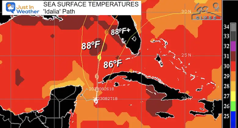
The computer model forecast may not fully account for the warm water, adding to the question of how strong this may get. If you have noticed in each report, the forecast continues to crank this up one level/category higher.
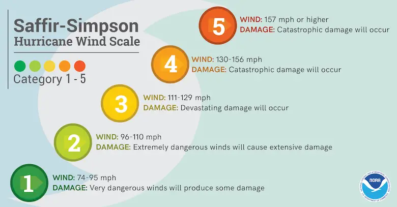
Ranking of Categories Based On Wind Speed
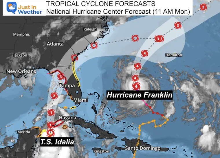
Computer Model Guidance suggested landfall
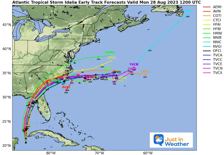
This includes Idalia And Franklin
This wide view shows the projected landfall Wednesday morning, then reemergence into the Atlantic Wednesday evening. Followed by skimming the coasts of South and North Carolina until Thursday. Then it may restrengthen a little as it heads back into open water.
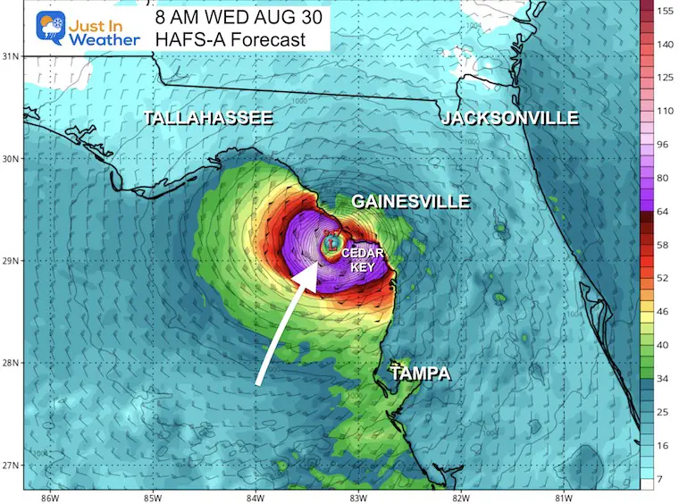
Possible Landfall as a Category 3 or higher hurricane
‘Near Cedar Key’.
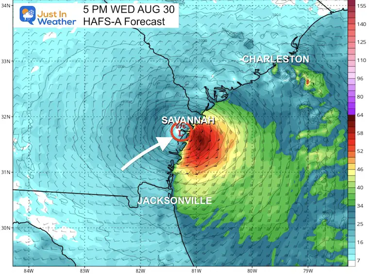
Possible reemergence into the Atlantic Near Savannah, GA. It will be downgraded to a Tropical Storm at this time after weakening over land.
After spending nearly a day within 100 miles or so of the coastlines of South and North Carolina, the Tropical Storm or Depression (after weakening) may have a chance to restrengthen a little.
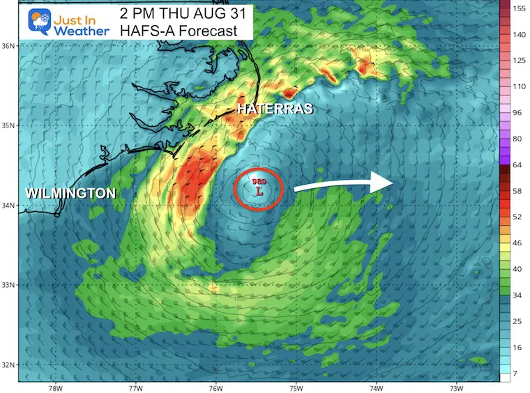
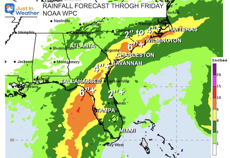
Along the path and east of the center, a wide area of 6 inches or more of rain is possible. A broader 4 inches or more can be seen in the yellow shading from Southwest Florida to Cape Hatteras, NC. A sharp cut off of the rain to the north.
This is a Category 4 Storm with 145 mph winds. While it is in the open water and not expected to make landfall, high waves will be imparting the East Coast.
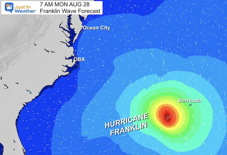
Hurricane Force Winds Extend 35 miles from the center
Tropical Storm Force Winds Extend 150 miles from the center.
Ocean City, MD, may get 4 to 6-foot swells peaking Wednesday morning.
There will be additional flow from the Southeast with the next system over the weekend.
I will have a follow-up and recap on our amazing week shortly.


I am aware there are some spelling and grammar typos and occasional other glitches. I take responsibility for my mistakes, and even the computer glitches I may miss. I have made a few public statements over the years, but if you are new here you may have missed it: I have dyslexia, and found out during my second year at Cornell University. It didn’t stop me from getting my meteorology degree and being the first to get the AMS CBM in the Baltimore/Washington region. One of my professors told me that I had made it that far without knowing, and to not let it be a crutch going forward. That was Mark Wysocki and he was absolutely correct! I do miss my mistakes in my own proofreading. The autocorrect spell check on my computer sometimes does an injustice to make it worse. I also can make mistakes in forecasting. No one is perfect at predicting the future. All of the maps and information are accurate. The ‘wordy’ stuff can get sticky. There has been no editor who can check my work when I need it and have it ready to send out in a newsworthy timeline. Barbara Werner is a member of the web team that helps me maintain this site. She has taken it upon herself to edit typos when she is available. That could be AFTER you read this. I accept this and perhaps proves what you read is really from me… It’s part of my charm.
#FITF