


May 9 Cooler With Rain And Severe Storm Risk Tonight South
Thursday May 9 Morning Report Today is the first day of the year with sunrise before 6 AM in Baltimore, but we won’t see it. After a high temperature of…
July 3, 2023
Monday Morning Update
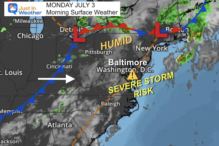
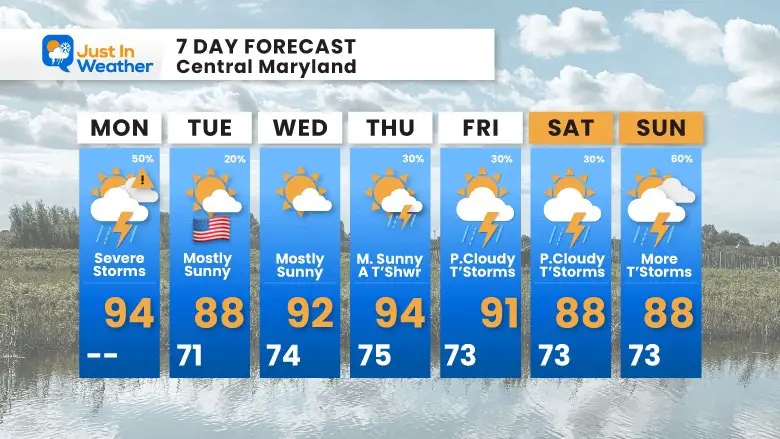
The weather is finally behaving like the season, which has brought back the heat and humidity. If you are a cynic, then the talk of thunderstorms would just be ‘expected’. However, we do have a Slight Risk for storms to turn severe again this afternoon.
The activity yesterday was not as widespread as advertised by the short range models I showed, but it did flare up in some places.
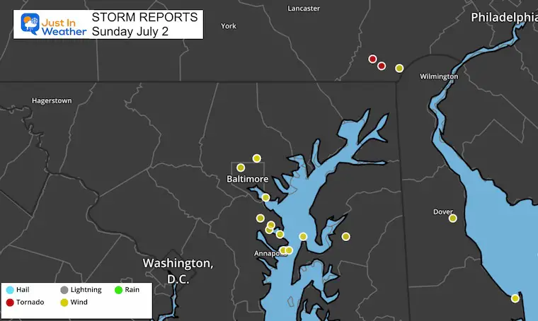
Many missed the severe weather, but those that got it were clobbered. The cluster in central Maryland erupted between 6 PM and 8 PM and left a trail of wind damage and downed trees between Baltimore and Anne Arundel County. There were a few tornadoes in southern Pennsylvania. This included near Harrisburg and west of Philadelphia.
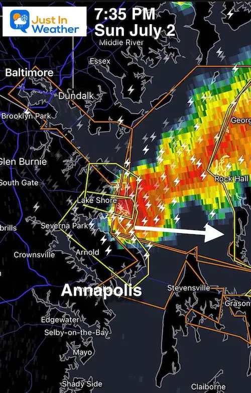
At 6:30 PM this cell popped up over Baltimore City and promoted a ‘warning’… It developed on the southern edge into parts of Anne Arundel County.

At 7:35 PM the southern tail of the storm cell was dropping into Anne Arundel County but stayed north of Annapolis. The area affected was between I-95 and Rt. 50… Then it moved across the Bay.
Also This: Super Moon
There is a full Super Moon today. If you saw it rise yesterday, or get to watch it this evening it may look larger than normal. This full moon is called the Buck Moon, and this time it coincides with the closest part of the orbit around Earth, called perigee. This makes it appear 7% larger than normal.
In typical summer fashion, many weather patterns remain stagnant. Storm systems are slower and in this case, we remain in the heat and humidity with instigation in the atmosphere to produce storms later. These have a chance to become strong or severe.
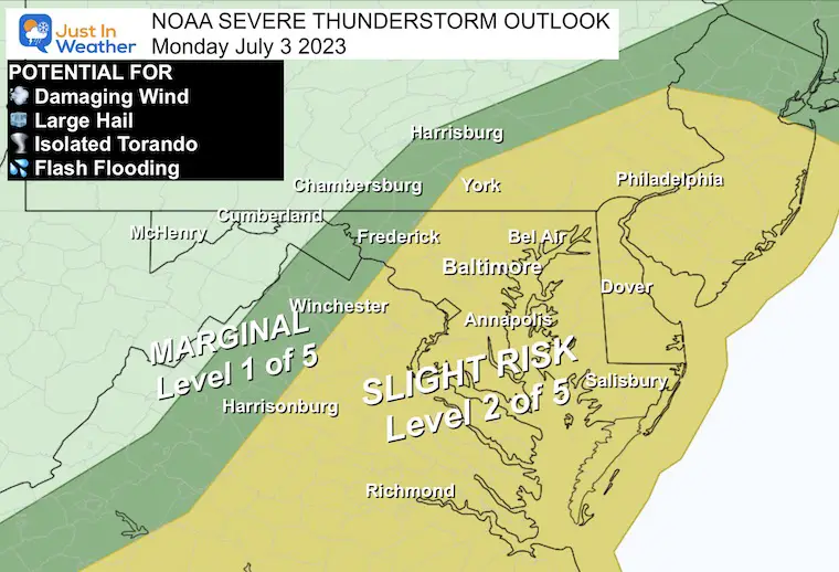
The ‘Slight Risk’ in yellow is Level 2 of 5. While this nearly matches what was issued yesterday, it does not mean a repeat. We still should respect the potential for any thunderstorm to turn severe.
A storm is considered SEVERE if it contains:
*Any thunderstorm can contain dangerous lightning. The most dangerous is before the first drop of rain, so best to get inside before you get wet.
The timing will be AFTER 3 PM in this area. The radar simulation below helps identify locations that may be close to you… It will be earlier west, later on the Eastern Shore.
Note: There could be a few waves of storms, so it may not be one-and-done.
I don’t expect much action until the heat of the day, but I am showing this here in case you view this post later in the afternoon to compare it to the model plots below.
I need to remind you that these products are NOT perfect. They are suggestions AND the subtly of developing storms can vary widely depending on where and when they pop up. I will compare the models in one hour plots below for you to see what we are up against.
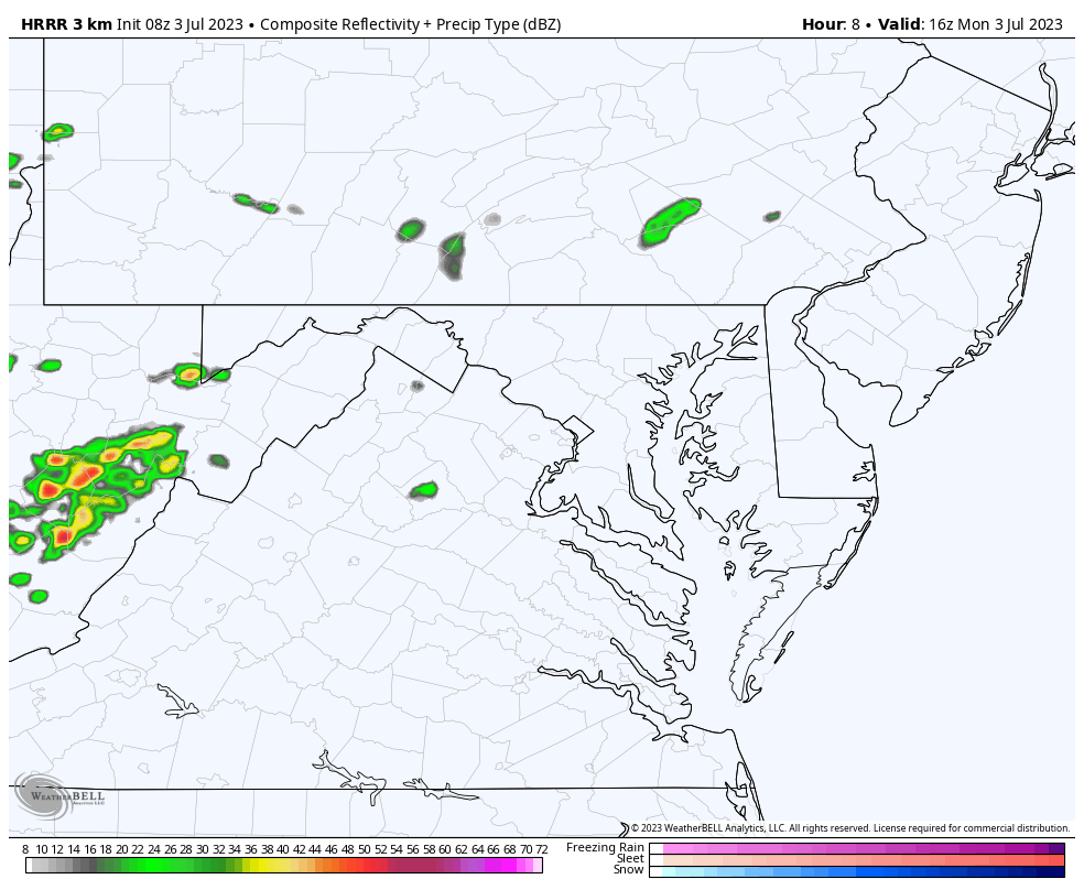
These are suggestions, not perfect! It is best to consider a buffer of one hour earlier or later than shown here.
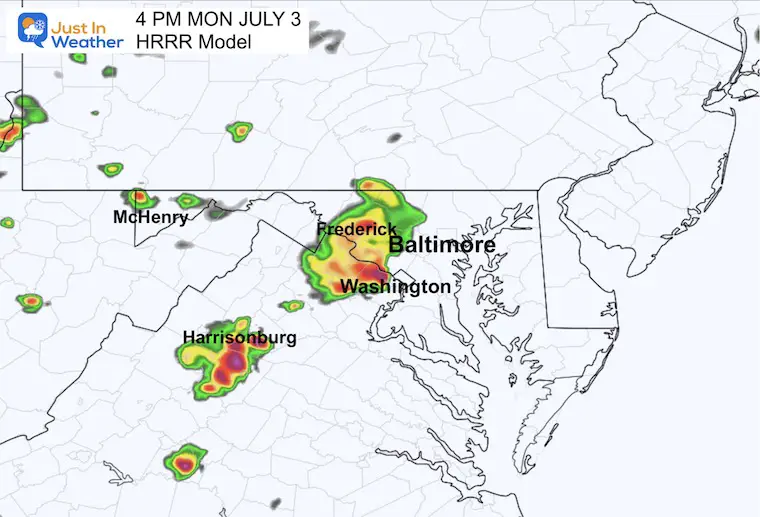
This model is suggesting the storms will get going in the mountains after 2 PM. By this time, they may be over Frederick and expanding over the western suburbs of Washington DC.
In Central Maryland: I would pay attention in Frederick, Montgomery, Howard, and Carroll Counties.
Here we see the flare-up of storms in central Maryland between Baltimore and Annapolis. There may be an extension of that line with severe storms in central Virginia.
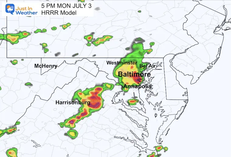
The ‘suggestion’ is that multiple clusters will form along a line. One impulse will reach Northeastern Maryland, while the second will be pounding metro Washington.
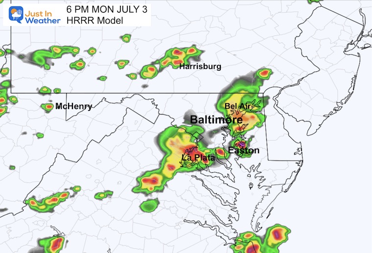
This model concentrates the storms farther west.. or slower. The suggestion here is for the north edge to be focused around Harrisburg PA with a second between Washington and Baltimore in MD.
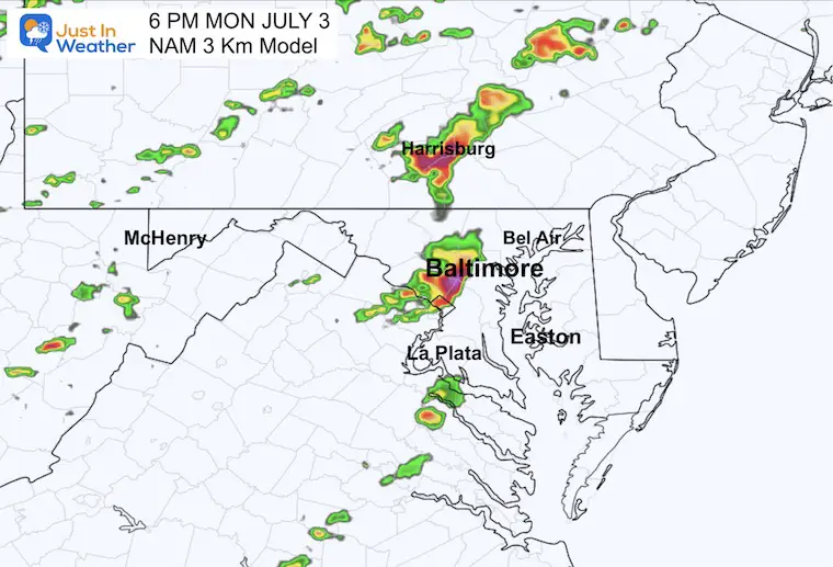
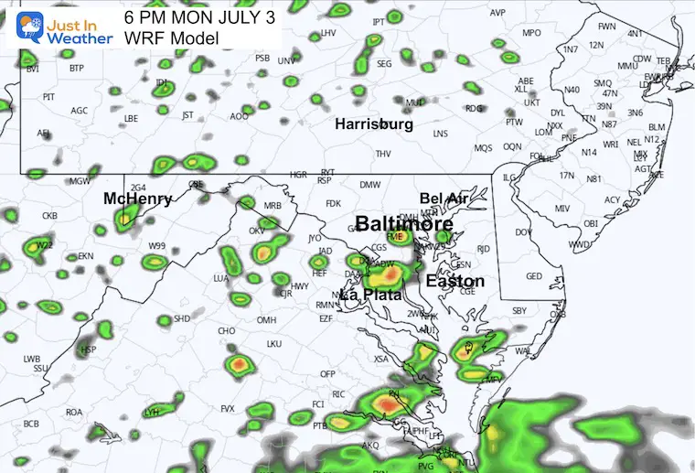
This was the model I chose to show you yesterday, but it was overactive. Today it is the least active with a couple of less potent storm cells in central Maryland.

Normal Low in Baltimore: 67ºF
Record 50ºF in 2001
Normal High in Baltimore: 89ºF
Record 104ºF 1898
We should end up with a calmer and slightly cooler day. There is still a small chance for an isolated pop-up shower. Most of us will remain dry.
The heat and humidity will build back this week. With it comes the standard chance for afternoon thundershowers. The pattern increases that chance later in the weekend.

I am aware there are some spelling and grammar typos, and occasional other glitches. I take responsibility for my mistakes, and even the computer glitches I may miss. I have made a few public statements over the years, but if you are new here you may have missed it: I have dyslexia, and found out during my second year at Cornell University. It didn’t stop me from getting my meteorology degree, and being first to get the AMS CBM in the Baltimore/Washington region. One of my professors told me that I had made it that far without knowing, and to not let it be a crutch going forward. That was Mark Wysocki and he was absolutely correct! I do miss my mistakes in my own proofreading. The autocorrect spell check on my computer sometimes does an injustice to make it worse. I also can make mistakes in forecasting. No one is perfect predicting the future. All of the maps and information are accurate. The ‘wordy’ stuff can get sticky. There has been no editor that can check my work when I needed it and have it ready to send out in a newsworthy timeline. Barbara Werner is a member of the web team that helps me maintain this site. She has taken it upon herself to edit typos, when she is able. That could be AFTER you read this. I accept this and perhaps proves what you read is really from me… It’s part of my charm.
#FITF