


May 19 Weather Sunday Starts Foggy The Warming With Sun And Summer Heat On The Way
Sunday May 19 Morning Report The aftermath of the rainy Saturday is plenty of leftover moisture. This has left us with a bit of humidity and areas of thick fog…
June 26, 2023
Monday Morning Update
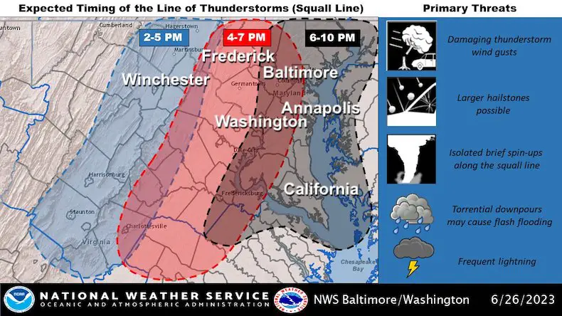
The weather set up today supports an eruption of severe storms. With the humidity in place, higher temperatures, wind direction, wind shear, and colder air aloft all combine into what may be a widespread outbreak of extreme weather.
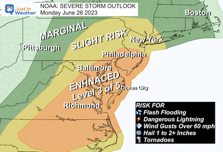
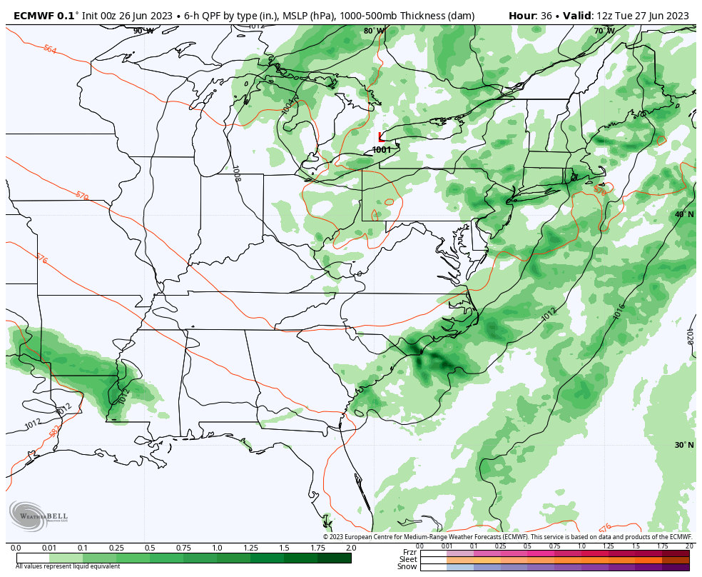
NOAA has expanded the Enhanced Risk for severe storms. That is level 3 out of 5 and I have more details and a potential timeline below. We can compare the forecast radar simulation to the live radar. While there could be a morning shower, the main activity will build after 2 PM.
Alerts Expected Today
Watch: This will be issued for a larger time window when there is POTENTIAL NOT A PROMISE for storm conditions to develop.
Warning: This is issued when storm conditions are OCCURRING NOW! This may be for flash flooding, damaging wind, large hail, or tornadoes.
Any storm can produce dangerous lightning.
The good news is that while we have storms through tomorrow, we may get the quiet weather to return on Wednesday and Thursday.
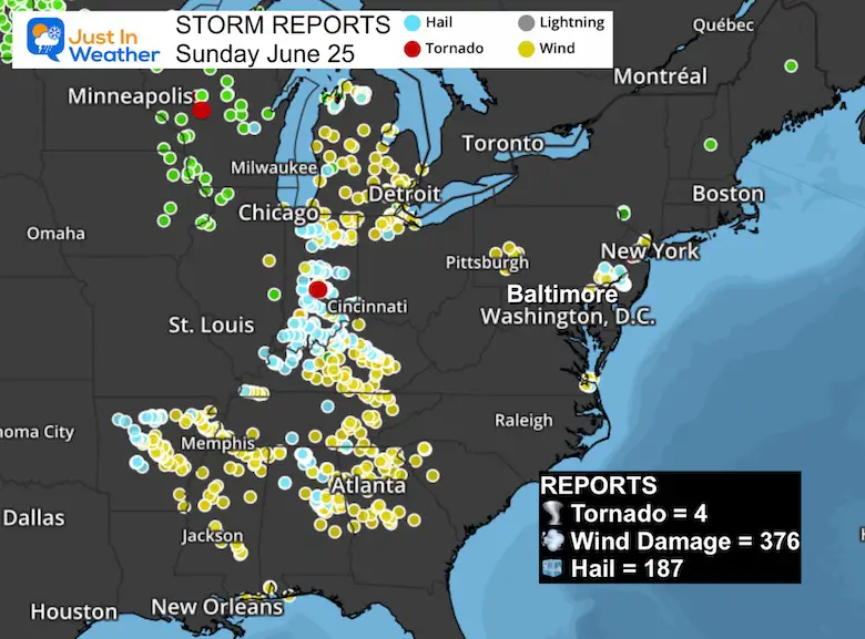
Looking back at yesterday, the Storm Prediction Center accounted for
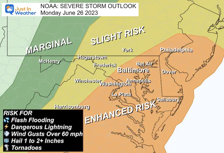
The Enhanced Risk bullseye includes most of eastern Virginia, Maryland, all of Delaware, into Southern New Jersey. The Slight Risk does reach up I-95 to metro New York.
The risk includes:
A Warm and Humid air mass is in place and the heat will crank up today through tomorrow.
A large cold core Low located over Minnesota is the reason for very active storms along that boundary. While a few pop-up showers will develop this afternoon. The severe storm risk will reach us today. This is a slow moving pattern, so it may stay with us for a few days.
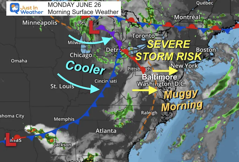
This will get more active after Noon
Where this line is located is based on the timing of the storm line forming. It is negotiable and not important if you are close to the edge. Just consider the risk for a busy afternoon.
Note: As I wrote in last night’s report: The conditions are favorable for widespread severe storms.
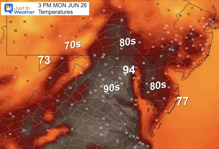
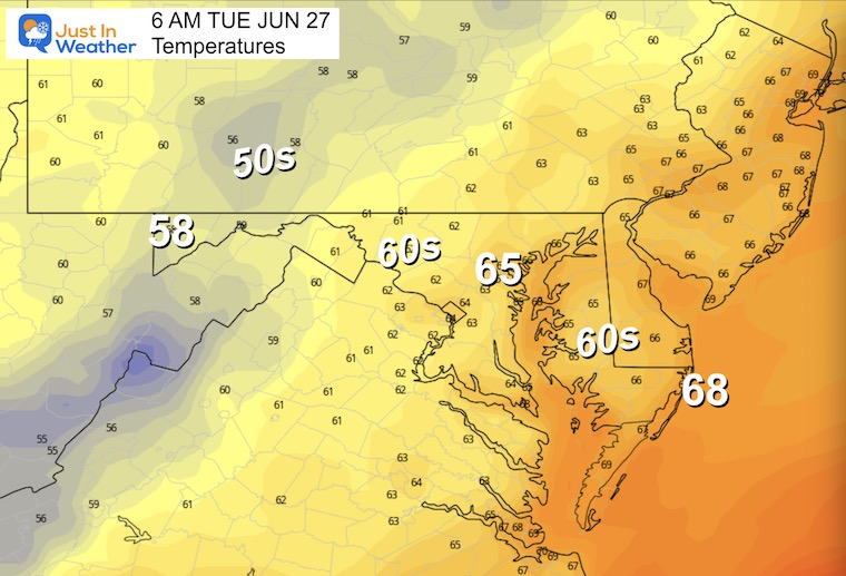
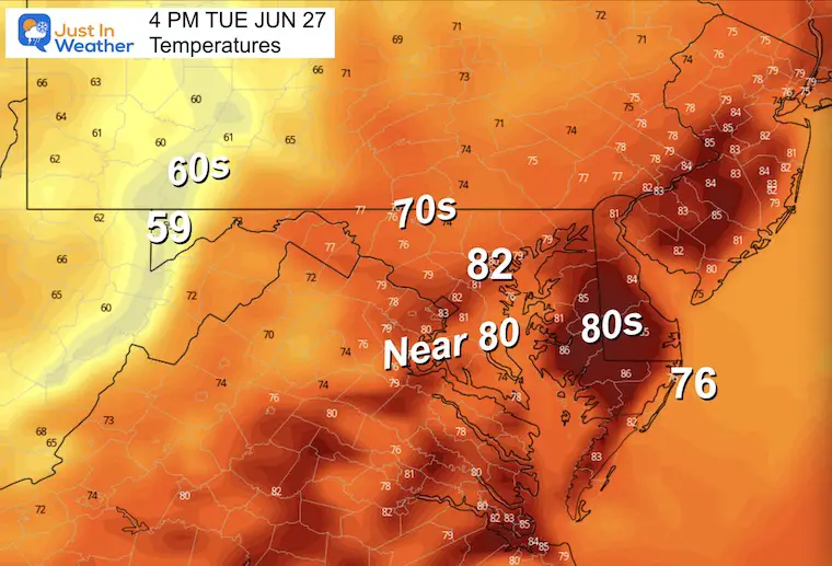
These are the expected peak temps before the storms roll in. Notice the drop into the 70s and 60s where the storms have passed.
I need to emphasize that this product is a good guide, but has limitations. It often is slower and less active than we end up seeing.
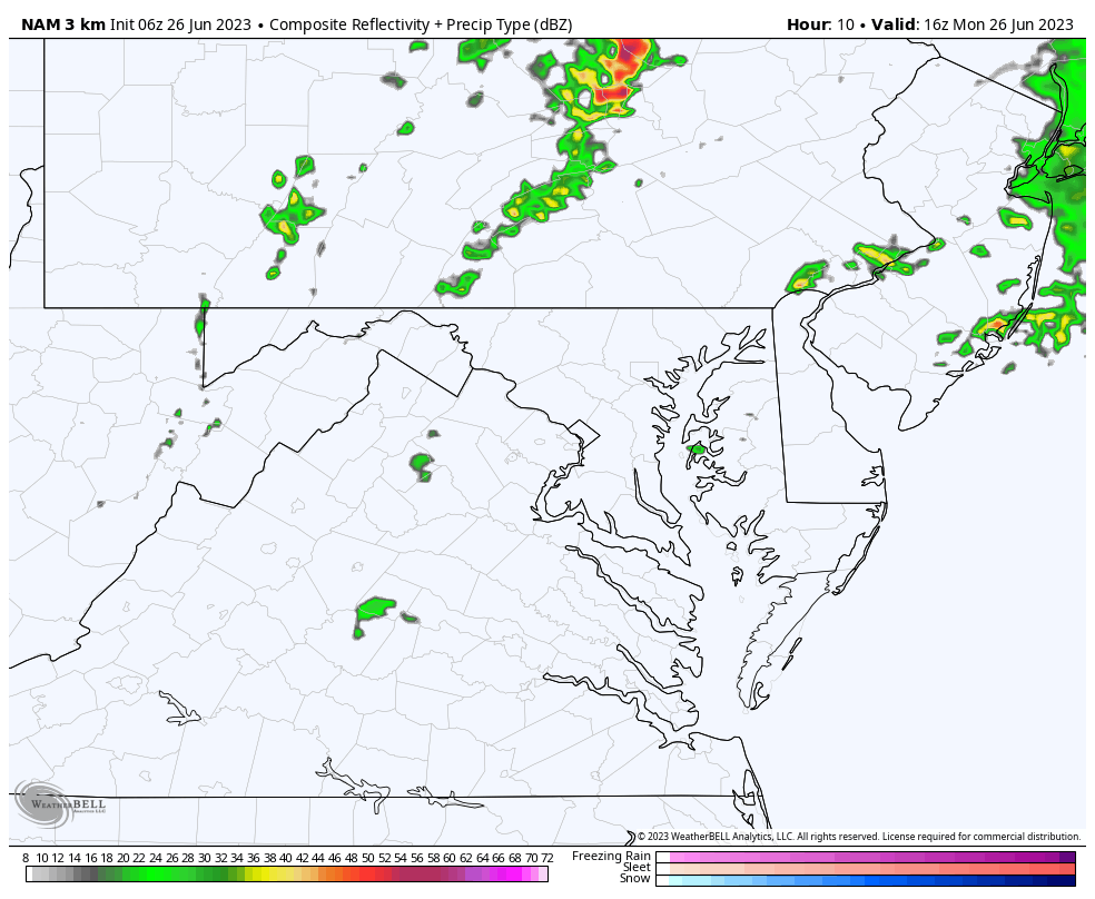
Reminder: We may verify storms up to 1 hour earlier and they could be more active than shown here.


Normal Low in Baltimore: 66ºF
Record 52ºF in 1986
Normal High in Baltimore: 88ºF
Record 99ºF 1954
Morning
It will be muggy, and there may be some thick fog to start the day.
Afternoon
Not as warm, but still unstable. More showers and storms will help to keep temps in check.
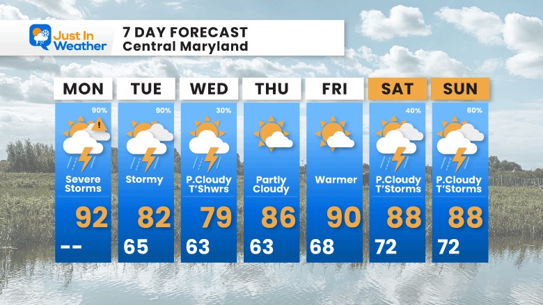
The continue ‘pulsing’ of storms each afternoon and evening will persist Tuesday and Wednesday. This is expected to settle back to scattered showers and more dry days towards the end of the week.
Tuesday: Widespread showers and thunderstorms again with potential for severe conditions. This can include flash flooding, damaging winds, large hail, and isolated tornados.
Wednesday and Thursday: We may turn quiet earlier than expected…
The latest suggestion is for the worst storms today, however tomorrow may be quite busy as well. Then we lower the storm chance on Wednesday, with Thursday and Friday turning quiet.
This holiday weekend will bring back more summer storms.

I am aware there are some spelling and grammar typos, and occasional other glitches. I take responsibility for my mistakes, and even the computer glitches I may miss. I have made a few public statements over the years, but if you are new here you may have missed it: I have dyslexia, and found out during my second year at Cornell University. It didn’t stop me from getting my meteorology degree, and being first to get the AMS CBM in the Baltimore/Washington region. One of my professors told me that I had made it that far without knowing, and to not let it be a crutch going forward. That was Mark Wysocki and he was absolutely correct! I do miss my mistakes in my own proofreading. The autocorrect spell check on my computer sometimes does an injustice to make it worse. I also can make mistakes in forecasting. No one is perfect predicting the future. All of the maps and information are accurate. The ‘wordy’ stuff can get sticky. There has been no editor that can check my work when I needed it and have it ready to send out in a newsworthy timeline. Barbara Werner is a member of the web team that helps me maintain this site. She has taken it upon herself to edit typos, when she is able. That could be AFTER you read this. I accept this and perhaps proves what you read is really from me… It’s part of my charm.
#FITF