June 26 2023
Monday Afternoon Update
With the Enhanced Risk issued by NOAA for today, the expectation for storms to turn severe has been high. A Severe Thunderstorm Watch has been issued for the POTENTIAL of storms to turn severe. This is NOT A PROMISE.
I need to reinforce that as we watch thunderstorms develop, lines may form, then break into individual cells compressing and focusing the energy into smaller areas.
Maryland and Virginia were added just after I made this post. Please keep an open mind for storm any time between 4 PM to 10 PM.
A Watch means that is might happen. If and when storms do form, then a Warning will be issued to track a shorter time frame with specific towns in the path.
In this post, a breakdown of the alerts, afternoon weather set up, live radar, and forecast maps.
Severe Thunderstorm Watch
Until 9 PM Monday
Southern Pennsylvania and New Castle County, DE.
Flood Advisories are being added to the list as locally have downpours may lead to Flash Flooding.
Central Maryland may get added to the list.
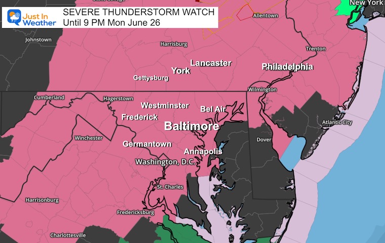
Storm Parameters
- Flash Flooding
- Dangerous Lightning
- Wind Gusts over 60 mph
- Large Hail 1 to 2+ inches in diameter
- A few tornadoes
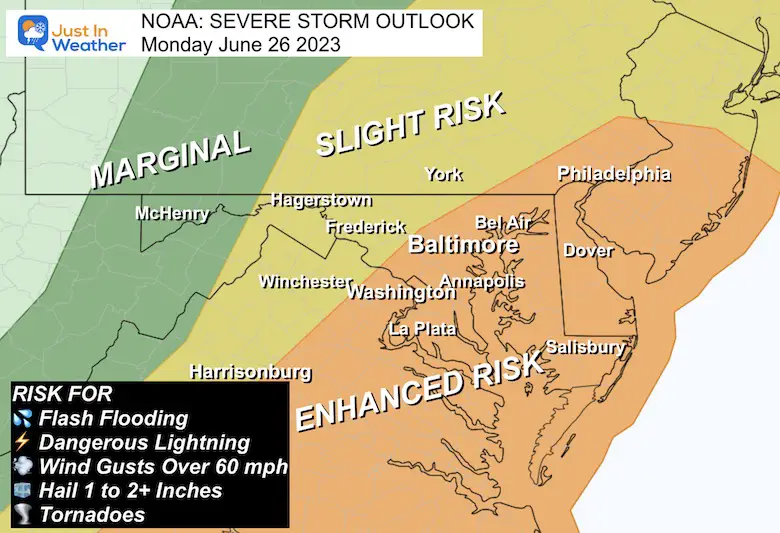
NOAA Severe Storm Risk
The Slight Risk (yellow) will be where the storms develop, but while they are still growing. This may include Winchester, VA, Frederick to Westminster in MD, and York/Lancaster in PA to metro New York.
Enhanced Risk (orange) is where the storms will encounter the max heat and humidity to reach peak storms between 5 PM and 9 PM. This includes Richmond, Washington, Annapolis, Baltimore Philadelphia, and all of Delmarva to the beaches.
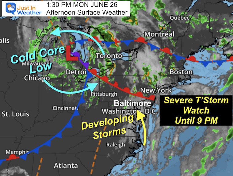
Afternoon Surface Weather
Surface Low Pressure was located north of Detroit. This is the source of the cool air and wind circulation aloft.
The warm sector is in the Mid Atlantic, where the strongest storms are expected to ignite this afternoon and evening.
The NWS Discussion did highlight that CAPE Values and wind sheer has lowered a little since the upgraded risk was expanded. However, there is still a risk for multiple severe storm cells to develop.
See the Live Radar below.
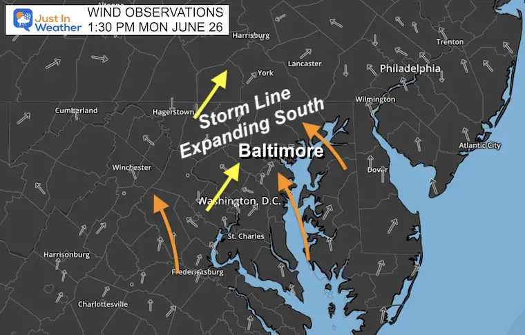
Wind Observations
The KEY for storm development and expansion in metro Baltimore/Central Maryland is wind direction. A Southeast wind is most prolific. The wind this afternoon is there, but not as well pronounced. I would watch this on local anemometers to give us a heads up on what may or may not develop.
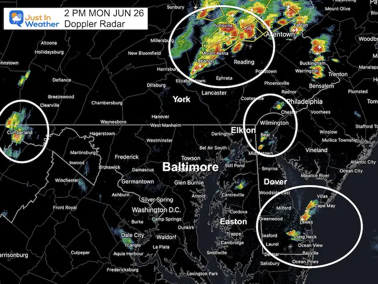
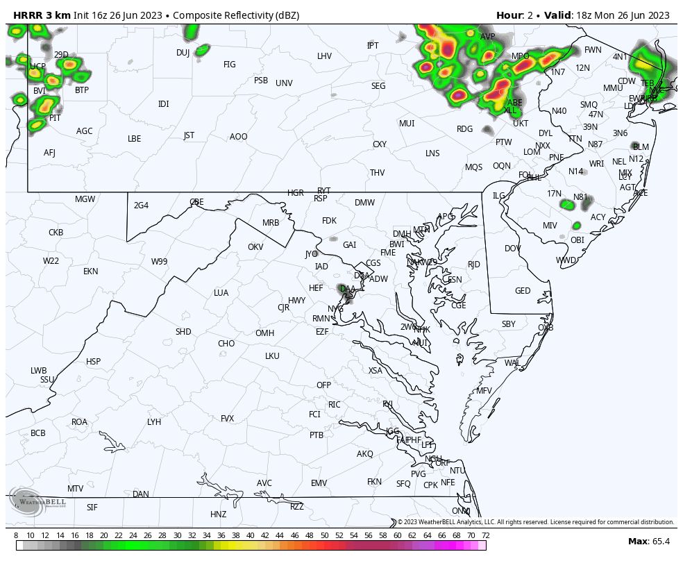
2 PM Doppler Radar Snapshot
There is a trough in the atmosphere that marks the humidity and wind shift, where storms appear to be setting up. This has become more active, and it is farther south into Maryland where more severe storms are expected to develop over the next few hours.
See the Live Radar below.
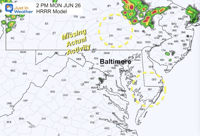
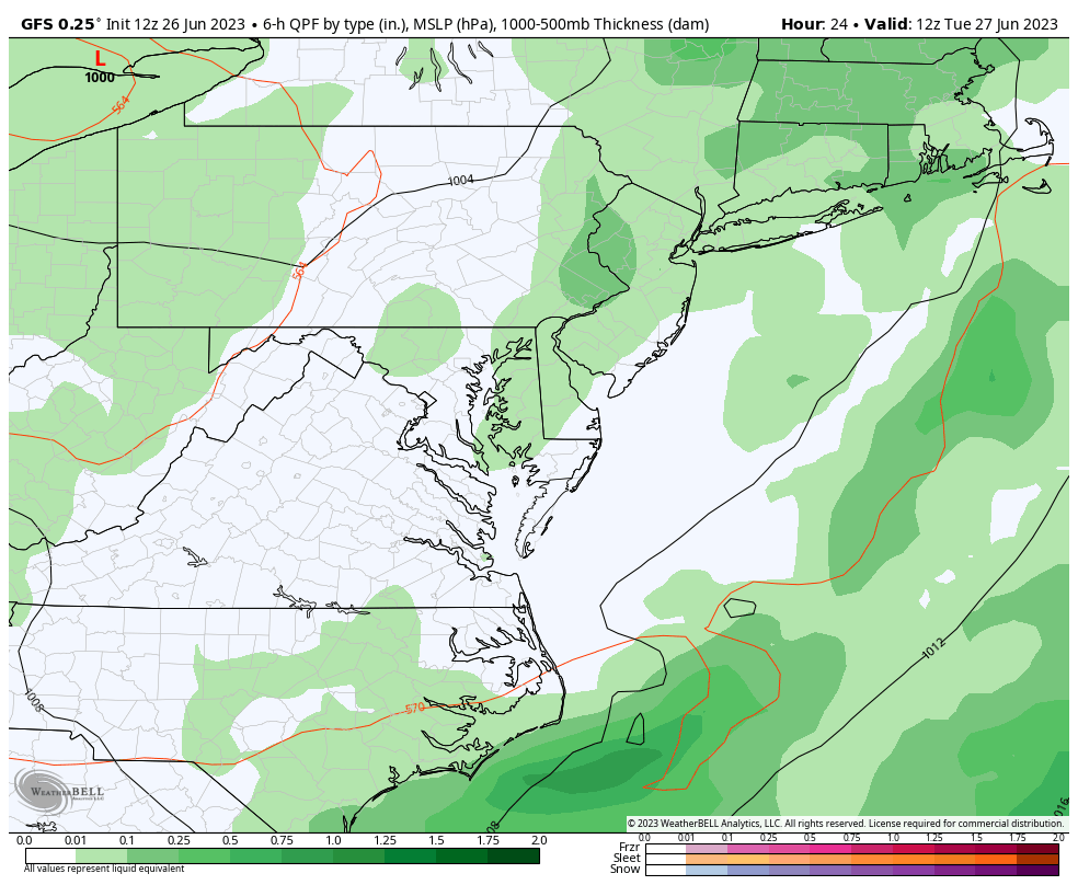
2 PM Forecast Snapshot
The HRRR Model is missing early development. So the confidence for the rest of the day is low… In other words I still believe we will see more than is shown here.
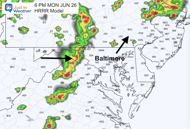
Snapshot 6 PM
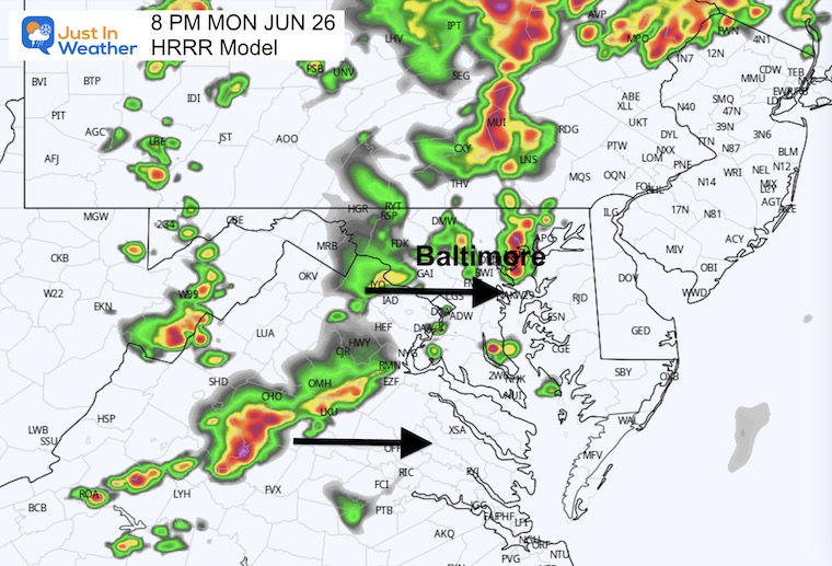
Snapshot 8 PM
Radar Simulation 2 PM to 2 PM
This HRRR Product has lowered the projection, but it is also missing the activity we see at 2 PM. I have low confidence in this product today, but it is a guide. This suggests the storm activity may actually be later to form and last later tonight.
Live Radar and Lightning
Use the controls to pan, zoom, and animate.
Looking Ahead
Tuesday To Thursday: GFS Model
We may have another active storm day Tuesday, the less on Wednesday. We could break the pattern with dry weather Thursday and Friday.
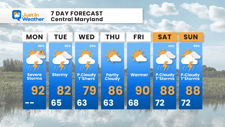
7 Day Forecast
The latest suggestion is for the worst storms today, however tomorrow may be quite busy as well. Then we lower the storm chance on Wednesday, with Thursday and Friday turning quiet.
This holiday weekend will bring back more summer storms.
Subscribe for eMail Alerts
EXPLORE MORE

Please share your thoughts, and best weather pics/videos, or just keep in touch via social media
RESTATING MY MESSAGE ABOUT DYSLEXIA
I am aware there are some spelling and grammar typos, and occasional other glitches. I take responsibility for my mistakes, and even the computer glitches I may miss. I have made a few public statements over the years, but if you are new here you may have missed it: I have dyslexia, and found out during my second year at Cornell University. It didn’t stop me from getting my meteorology degree, and being first to get the AMS CBM in the Baltimore/Washington region. One of my professors told me that I had made it that far without knowing, and to not let it be a crutch going forward. That was Mark Wysocki and he was absolutely correct! I do miss my mistakes in my own proofreading. The autocorrect spell check on my computer sometimes does an injustice to make it worse. I also can make mistakes in forecasting. No one is perfect predicting the future. All of the maps and information are accurate. The ‘wordy’ stuff can get sticky. There has been no editor that can check my work when I needed it and have it ready to send out in a newsworthy timeline. Barbara Werner is a member of the web team that helps me maintain this site. She has taken it upon herself to edit typos, when she is able. That could be AFTER you read this. I accept this and perhaps proves what you read is really from me… It’s part of my charm.
#FITF


