


May 9 Cooler With Rain And Severe Storm Risk Tonight South
Thursday May 9 Morning Report Today is the first day of the year with sunrise before 6 AM in Baltimore, but we won’t see it. After a high temperature of…
May 1, 2023
Monday Morning Update
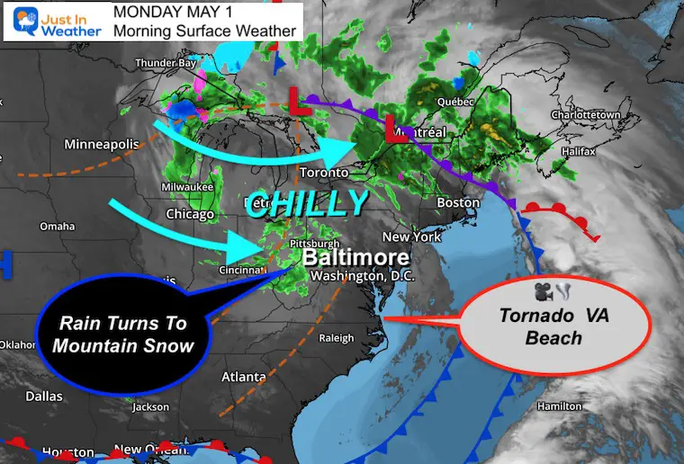
Come WHAT May? This weather pattern is very winter-like and for some will actually look and feel like winter this week. An unusual upper air pattern will send our weather back in time two months with the chill and showers that will feel like March. This includes accumulating snow in western Maryland and West Virginia that may break some records, plus trees and power lines in the process.
But first, the storm yesterday produced a tornado in Virginia Beach before expanding heavy rain up to Maryland.
Tornado Virginia Beach
You can hear the fear from Jannis Carleo talking about the roofs of houses getting ripped off.
Viewer video of the Virginia Beach tornado that left lots of damage in parts of the Great Neck area earlier this evening.
🎥: Jannis Carleo#vawx #tornado pic.twitter.com/1PiwCudOKf
— Kristy Steward (@KristyStewardWx) May 1, 2023
More Video
Ernie Sawyer captured this wider view
State Of Emergency
Some of the damage around Virginia Beach from Darin Deveau
Widespread tornado damage in Virginia Beach this evening. #vawx #virginiabeach #tornado pic.twitter.com/g3a91LXMUI
— Darin Deveau (@darin_deveauWX) May 1, 2023
Baltimore at BWI recorded 2.17” of rain since Friday. I will have more on the region rain in my next report.
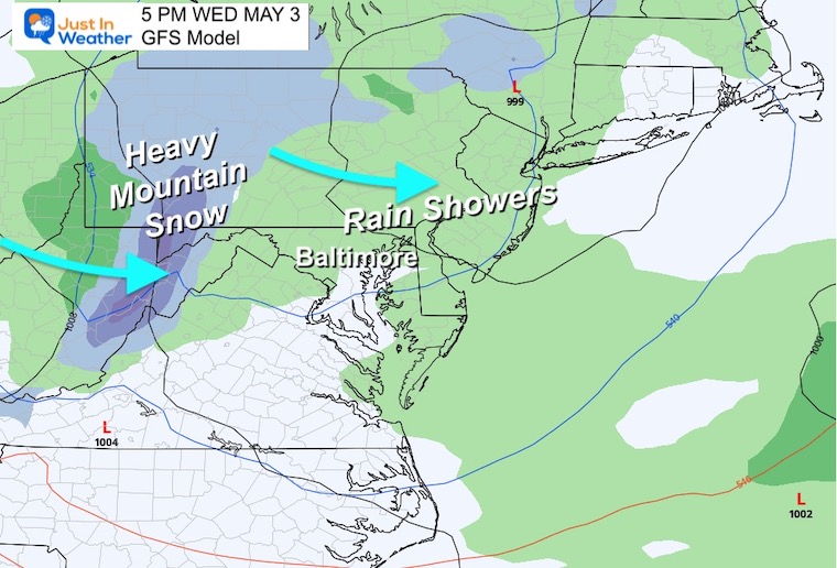
The large upper level Low moving into Northern New England is responsible for pivoting chilly and wet weather across the Ohio Valley and into the mountains. This will be our weather for most of this week.
See the Tornado Videos from Virginia Beach above.
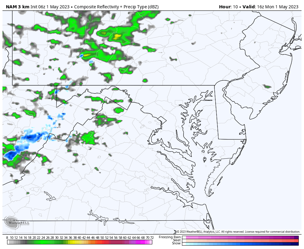
Rain showers will be developing in the afternoon into the evening. Some may be locally heavy and could have small hail.
These will be scattered and briefly increase the wind.
Notice the blue in the western Mountains… Snow will be developing and become more prominent Tuesday and Wednesday.
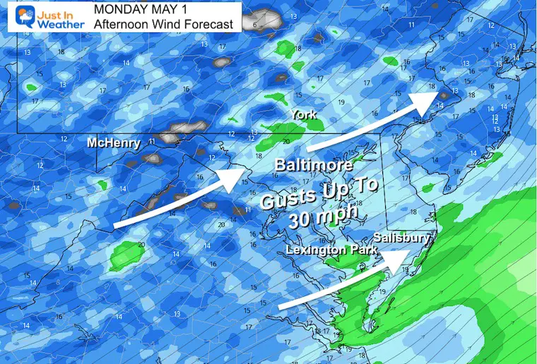
The West to Southwest Wind will be wrapping around the upper level Low, so it will be chilly! The push will be gusting up to 30 mph and even stronger in some rain showers.
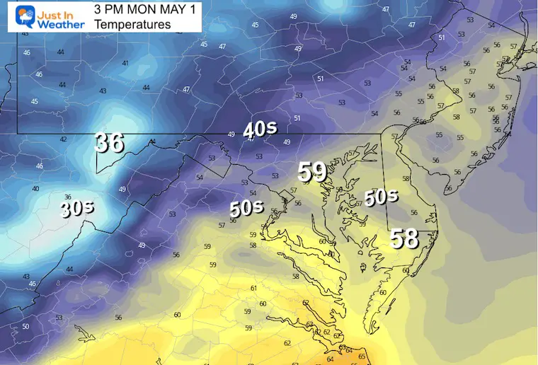
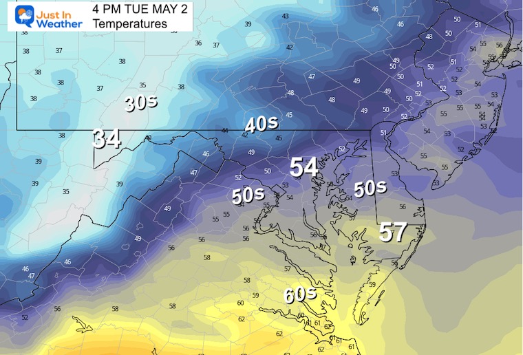
With the wind and rain showers, even if you get close to 60ºF it will be chilly. Many areas stay in the 50s.
TODAY May 1
Normal Low in Baltimore: 49ºF
Record 33ºF in 1876
Normal High in Baltimore: 72ºF
Record 89ºF 1895
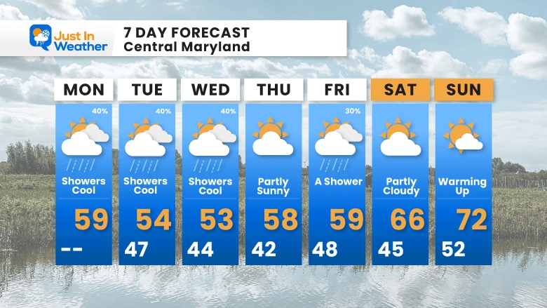
Continued chilly and similar for a few days.
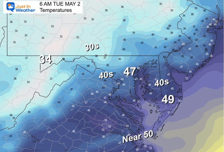
Temps will be steady or falling slightly through the lower 50s with the rain. These numbers will be 15 to 20 degrees BELOW AVERAGE and more like early March.
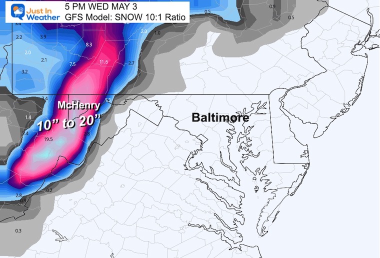
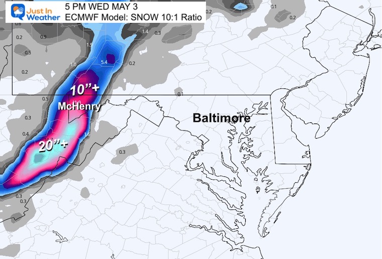
This GFS Model shows the cool unsettled pattern spinning around the Upper Level Low. The net result will be a flare up of rain showers during the day that settles at night. However, a few days with upslope snow in the high mountains.
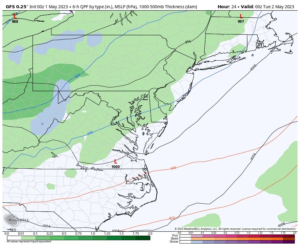
The snow shown will be falling, but the expectation for any stickage and accumulation is more likely ABOVE 2,000 Ft. This can be a serious power outage risk.
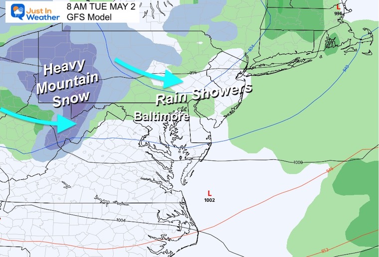
Continued snow falling in the mountains. Danger for any stickage on trees with full leaf bloom that can weigh down and break.
Accumulation will be more likely at night than during the day fighting with the daylight.
There is a difference between the GFS and ECMWF Models.
KEY INFO: Any snow accumulation on trees with foliage can lead to breakage AND downed powerlines resulting in outages.
The model forecast does not account for the melting and compression. I think it is prudent to cut these at least in 1/2, but still a lot of snow for May.
Storm Animation: Monday through Sunday
Persistent cool reinforcement of chilly air this week for the Eastern US and even Southern California.
The pattern will attempt to relax this weekend.
The core of the chilly air will reach the east coast on Wednesday with the Upper Level Low passing overhead.
The entire week will remain cool with high temperatures more common in Mid March. The rain showers will be scattered each day, not all out washouts. Snow in the mountains will be the main story.
The pattern may relax and get back closer to normal this weekend.

Click to see more and ‘Book’ a visit to your school

I am aware there are some spelling and grammar typos, and occasional other glitches. I take responsibility for my mistakes, and even the computer glitches I may miss. I have made a few public statements over the years, but if you are new here you may have missed it: I have dyslexia, and found out during my second year at Cornell University. It didn’t stop me from getting my meteorology degree, and being first to get the AMS CBM in the Baltimore/Washington region. One of my professors told me that I had made it that far without knowing, and to not let it be a crutch going forward. That was Mark Wysocki and he was absolutely correct! I do miss my mistakes in my own proofreading. The autocorrect spell check on my computer sometimes does an injustice to make it worse. I also can make mistakes in forecasting. No one is perfect predicting the future. All of the maps and information are accurate. The ‘wordy’ stuff can get sticky. There has been no editor that can check my work when I needed it and have it ready to send out in a newsworthy timeline. Barbara Werner is a member of the web team that helps me maintain this site. She has taken it upon herself to edit typos, when she is able. That could be AFTER you read this. I accept this and perhaps proves what you read is really from me… It’s part of my charm.
#FITF