May 1, 2023
Monday Night Update
The irony of one of the warmest winters on record is to be tracking snow in the month of May. Here we are with a winter weather pattern that will bring an exceptional set of circumstances to the high mountains of Garrett County in Maryland and West Virginia.
I have a lot of maps to share including a comparison of snow forecasts. The concern is that some trees have leafed out AND with a heavy wet snow, there may be broken trees and power lines.
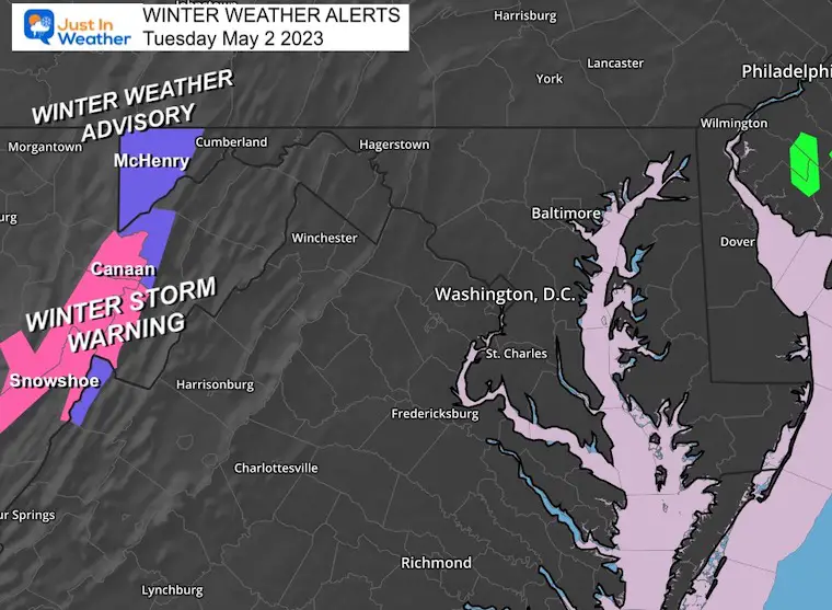
Let’s start with the official alerts, then the forecast maps.
Winter Weather Advisory
- Garrett County, MD
- Above 2,000 Ft: 1 to 3 inches
Winter Storm Warning
Total Snow: 4 to 6 inches, between 8 to 12+ on higher elevations. Winds gust to 45 mph
Winter Alert Maps
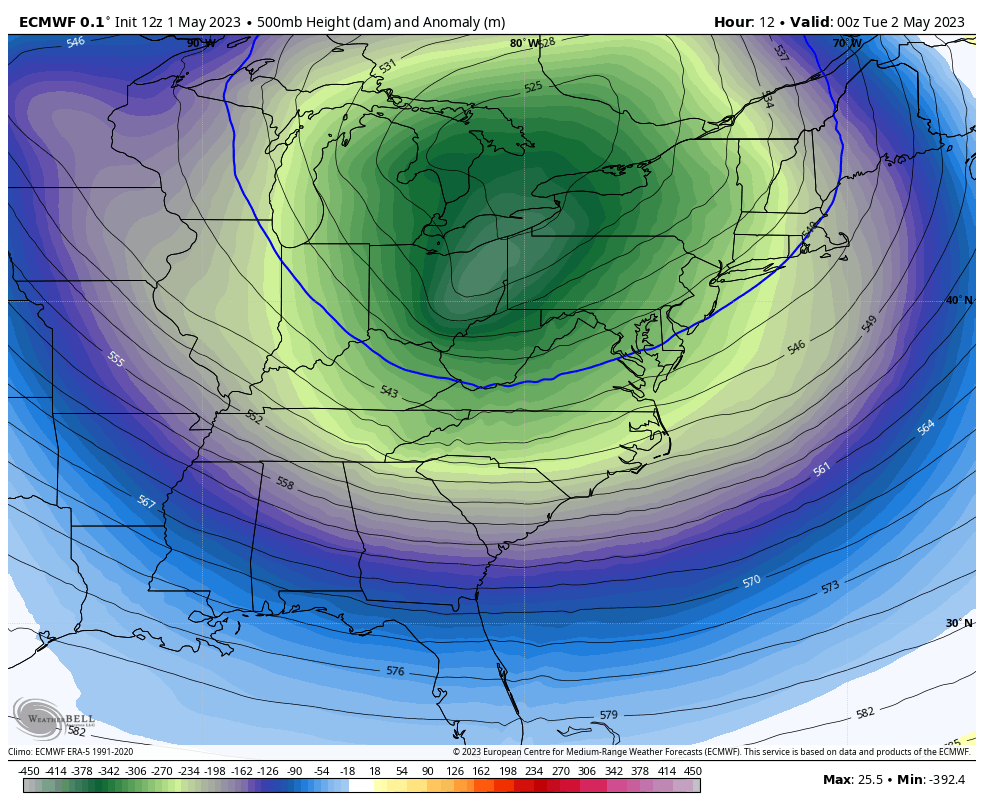
Upper Level Set Up
Some may argue this is the Polar Vortex entering the northern US. This circulation is the core of the cold air.
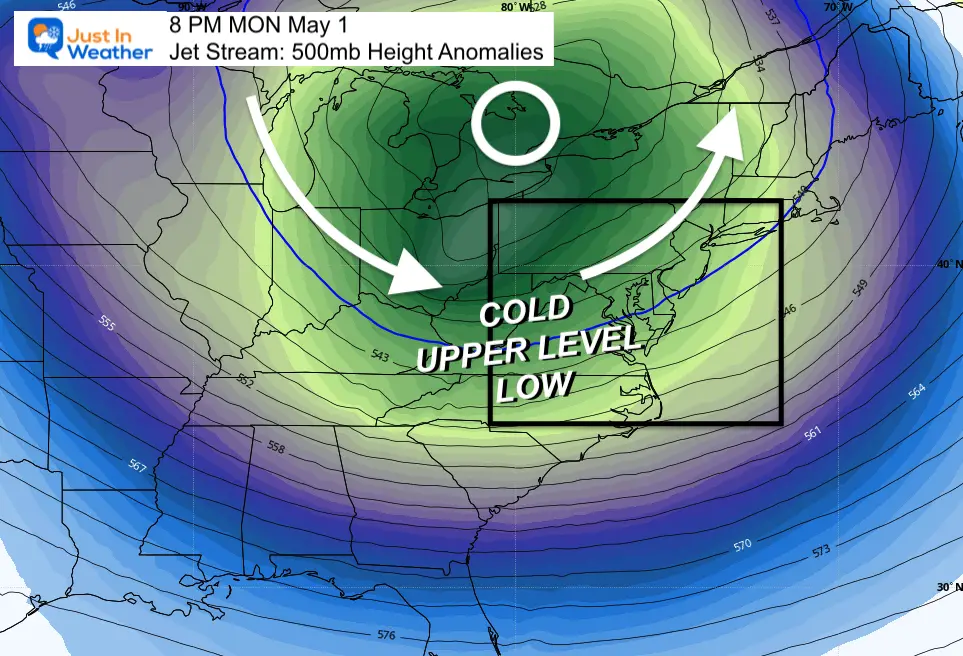
Jet Stream Animation: Mon Night to Thursday Morning
This will pivot through and may repeat on Wednesday, until moving off the coast Thursday.
Snow Monday Afternoon
This was on Mt. Davis in West Virginia at 1 PM. This is near 4,000 Ft in elevation. This may have been the first to get stickage. More is on the way.
Thanks Dave Podlesnik and Allegheny Mountains Weather
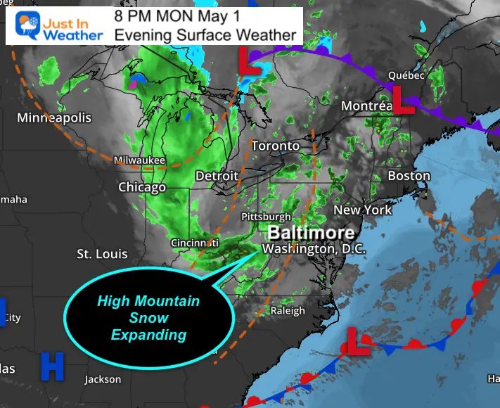
Monday Evening Surface Weather
A large pinwheel of rain has been wrapping around that Low Pressure. Metro areas will continue to get occasional rain showers for a few days.
The focus for this post is on the high mountains and expanding snow.
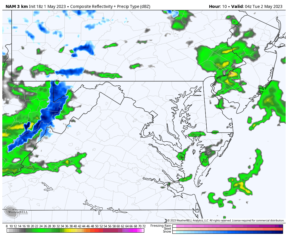
Radar Simulation: 12 AM Tuesday to 12 AM Wednesday
The blue shows the snow that will be developing tonight AND persist on Tuesday.
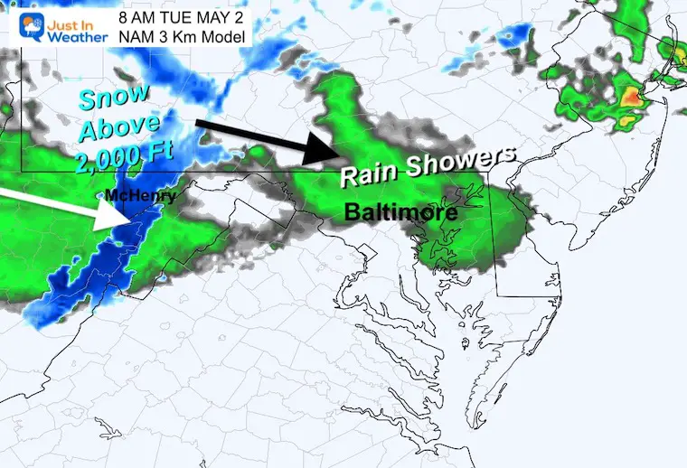
Snapshot 8 AM Tuesday
At this point snow will be falling. The stickage will be dependent on intensity and elevation. Not all locations that get snow on tress and grass will have roads covered. However, if there are road impacts, it will likely melt with the May sun angle during the daylight.
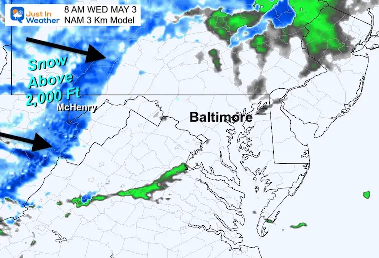
Snapshot 8 AM Wednesday
After a second night of snowfall, the ground may sufficiently cool down enough to support more stickage this morning.
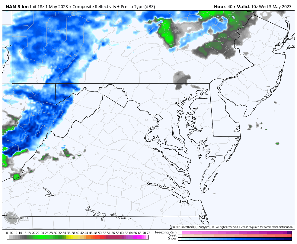
Wednesday Snow: 6 AM to 8 PM
Snow will continue and break up later in the day.
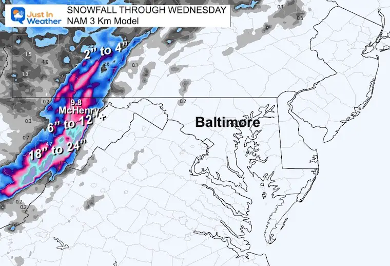
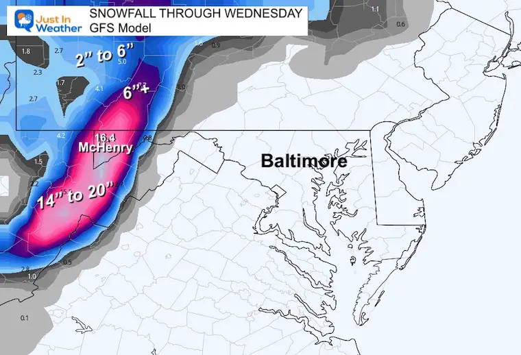
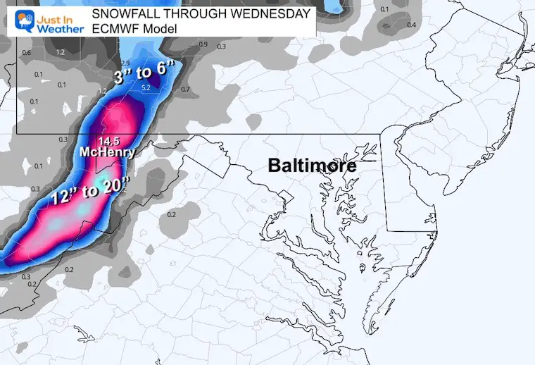
How Much May Fall?
I am about to show you a comparison of the official NWS snow forecast and computer models. I believe they may be over-blowing it, by not accounting for melting and compaction.
NAM 3 Km Model
GFS Model
ECMWF Model
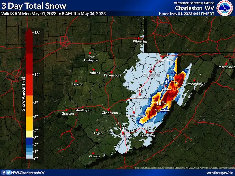
Nation Weather Service
Charleston, West Virginia
Here they are showing a lower range, but still 18”+ near and north of Snowshoe.
Faith in the May Mountain Flakes
OTHER REPORTS:
NEW:

STEM Assemblies/In School Fields Trips Are Back
Click to see more and ‘Book’ a visit to your school

Please share your thoughts, best weather pics/videos, or just keep in touch via social media
RESTATING MY MESSAGE ABOUT DYSLEXIA
I am aware there are some spelling and grammar typos, and occasional other glitches. I take responsibility for my mistakes, and even the computer glitches I may miss. I have made a few public statements over the years, but if you are new here you may have missed it: I have dyslexia, and found out during my second year at Cornell University. It didn’t stop me from getting my meteorology degree, and being first to get the AMS CBM in the Baltimore/Washington region. One of my professors told me that I had made it that far without knowing, and to not let it be a crutch going forward. That was Mark Wysocki and he was absolutely correct! I do miss my mistakes in my own proofreading. The autocorrect spell check on my computer sometimes does an injustice to make it worse. I also can make mistakes in forecasting. No one is perfect predicting the future. All of the maps and information are accurate. The ‘wordy’ stuff can get sticky. There has been no editor that can check my work when I needed it and have it ready to send out in a newsworthy timeline. Barbara Werner is a member of the web team that helps me maintain this site. She has taken it upon herself to edit typos, when she is able. That could be AFTER you read this. I accept this and perhaps proves what you read is really from me… It’s part of my charm.
#FITF
Subscribe for eMail Alerts


