April 30 2023
Sunday Afternoon Update
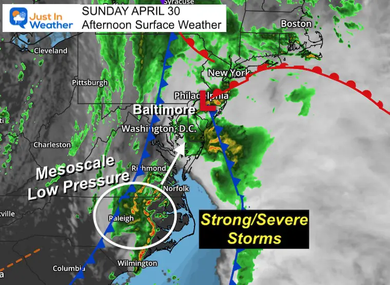
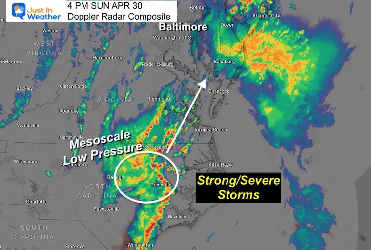
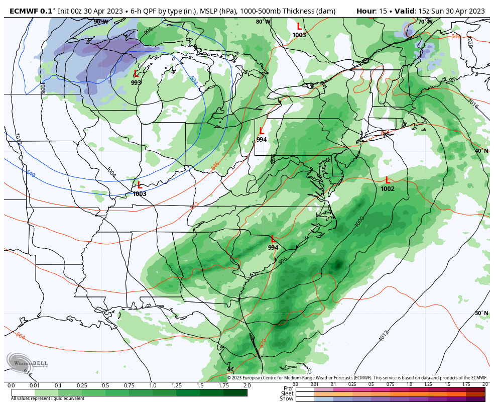
This weather system has more to go. After the Low Pressure that spread steady and heavy rain already today, there is another one forming to the south. This mesoscale Low is racing to the Northeast. While the core is located in North Carolina and the individual cells are going at 25 mph, the spread will reach Southern Maryland and Delmarva into this evening.
This will bring a cluster of heavy rain with lightning/thunder. This system has a history of warnings with local flash flooding, hail, and even tornadoes. So we must remain on the lookout through this evening. Addition rainfall could be as much as 1 to 3 inches along the path of repeating storm cells.
Afternoon Surface Weather
This potent meso-Low is intensifying quickly. This will be a concern for local flooding rain and wind damage as it swings though.
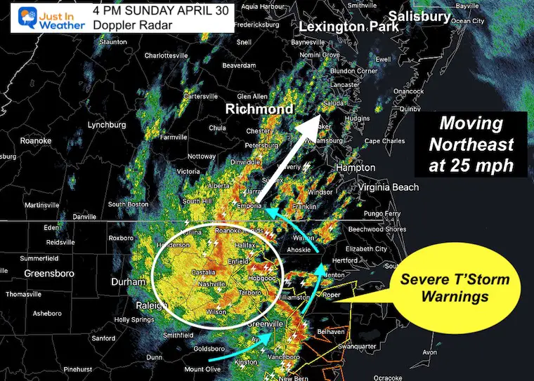
Doppler Radar at 4 PM
The main system is in North Carolina where widespread warnings have been issued on the east side of the circulation. This complex is expanding along the path to the Northeast. So storms will be erupting in Southern Maryland soon.
Additional rainfall could be 1 to 3 inches this evening.
Regional Radar at 4 PM
The cells are moving to the Northeast at 25 mph, but we can see the lines of heavy rain bands expanding along the path. So as the first heavy rain band is exiting Delaware the next is not far behind.
Live Radar and Lightning Widget
Compare to the simulation and key time frames below.
Radar Simulation
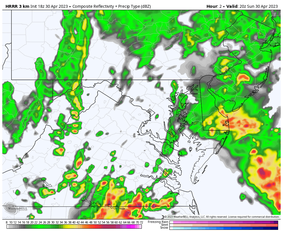
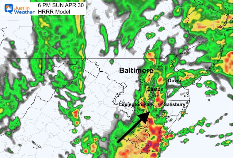
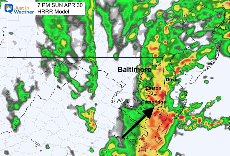
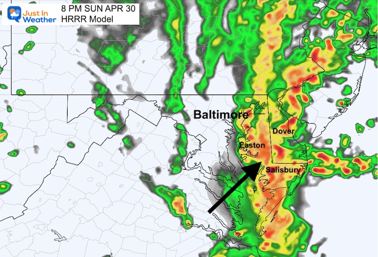
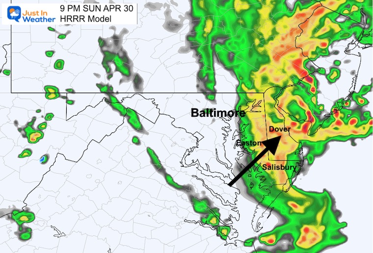
HRRR Model: 4 PM to Midnight
This has been the better performing model, so we are sticking with it.
Key Timeframes
Please note that there may be a buffer of an hour earlier or later than shown here.
6 PM
7 PM
8 PM
9 PM
Reminder From My Morning Report
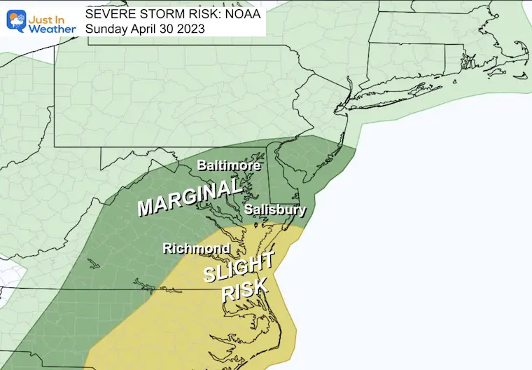
Severe Storm Risk
Most of Maryland is in the ‘Marginal’ or lowest level. This means that thunderstorms are possible, with a small chance for them to turn severe.
The SLIGHT RISK area in yellow has a higher chance for storms to produce damaging winds and large hail.
NOTE: I’ve seen recent events verify farther NORTH with the storms. ALSO – The line developing on the simulation below suggests that local flash flooding is still a possibility across Southern Maryland and around The Chesapeake Bay.
Rest Of The Forecast
Storm Animation: Sunday Through Wednesday
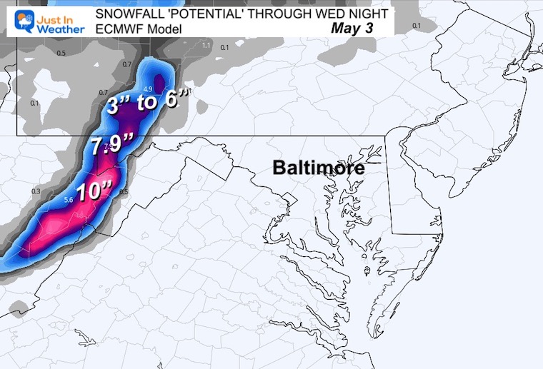
I backed up to this wider view to show the full circulation and orbit of weather systems around this cold upper level Low in the Great Lakes.
It will produce snow in the higher elevations, mainly ABOVE 2,000 Ft. Accumulation is possible, especially during the dark night hours across Garrett Co. MD and nearby West Virginia.
Yes, they have had snow in May before.
Snow Forecast
This is assuming a 10:1 ration and all the snow sticks… Most likely there will be melting and compression. We could safely assume totals may be half of what we see here.
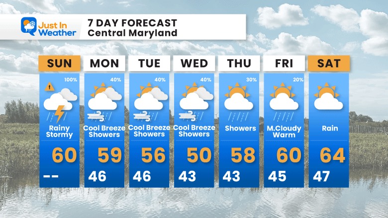
7 Day Forecast
The entire week will remain cool. While we see showers on each day through Friday, they will be scattered showers with the unsettled chilly pattern. Most showers will be in the afternoon, and decrease later in the week.
OTHER REPORTS:
NEW:

STEM Assemblies/In School Fields Trips Are Back
Click to see more and ‘Book’ a visit to your school

Please share your thoughts, best weather pics/videos, or just keep in touch via social media
RESTATING MY MESSAGE ABOUT DYSLEXIA
I am aware there are some spelling and grammar typos, and occasional other glitches. I take responsibility for my mistakes, and even the computer glitches I may miss. I have made a few public statements over the years, but if you are new here you may have missed it: I have dyslexia, and found out during my second year at Cornell University. It didn’t stop me from getting my meteorology degree, and being first to get the AMS CBM in the Baltimore/Washington region. One of my professors told me that I had made it that far without knowing, and to not let it be a crutch going forward. That was Mark Wysocki and he was absolutely correct! I do miss my mistakes in my own proofreading. The autocorrect spell check on my computer sometimes does an injustice to make it worse. I also can make mistakes in forecasting. No one is perfect predicting the future. All of the maps and information are accurate. The ‘wordy’ stuff can get sticky. There has been no editor that can check my work when I needed it and have it ready to send out in a newsworthy timeline. Barbara Werner is a member of the web team that helps me maintain this site. She has taken it upon herself to edit typos, when she is able. That could be AFTER you read this. I accept this and perhaps proves what you read is really from me… It’s part of my charm.
#FITF
Subscribe for eMail Alerts


