


May 12 Mothers Day Showers And Another Aurora Viewing Tonight May Be Better
Sunday May 12 Mother's Day Morning Report Today, we focus on the all-important Mother’s Day weather and the ongoing impact of the latest Solar Storm. We have been stuck in…
July 18 2022
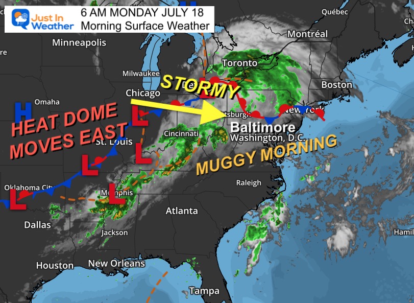
Monday Morning Update
This morning starts off muggy and this afternoon a slow moving front will work on the humidity to spark strong thunderstorms. NOAA has a slight risk for severe storms and I have two radar simulations below. We can anticipate another set up to produce more than models suggest.
The greatest risk today will be Flash Flooding and dangerous lightning. Some storms may produce damaging winds, but that will be more ‘spotty’ than the widespread event we saw last week.
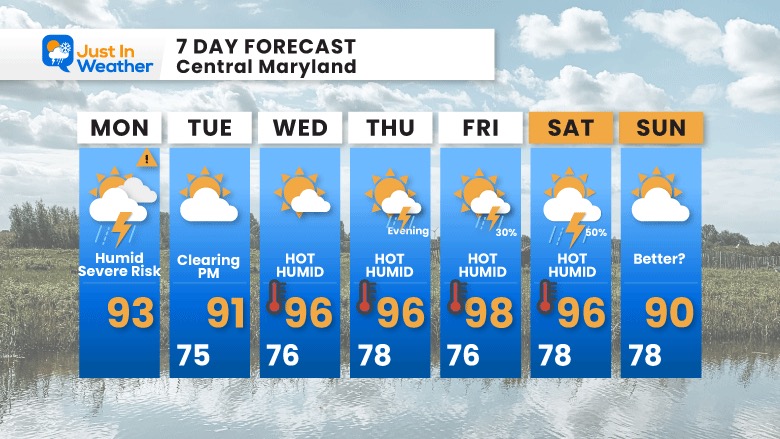
What follows will be our first true heat wave of the summer, but the high humidity might be the main issue.
It is Muggy and will be similar all this week.
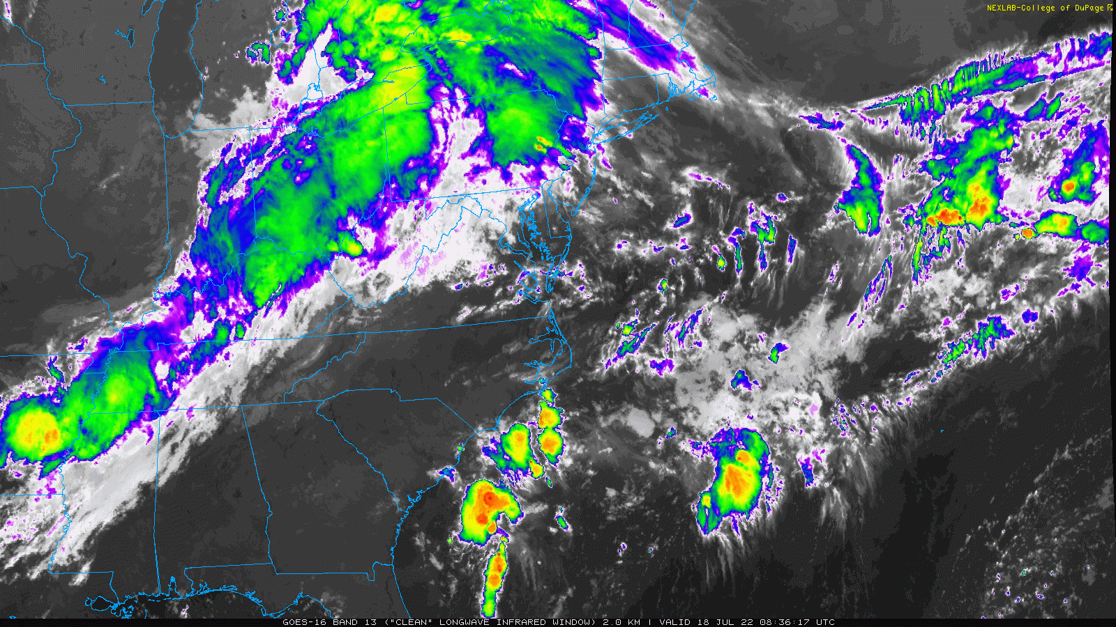
That line of clouds is our impulse. Timing this with the heat of the day is the program for today.
Main risk for Flash Flooding and Dangerous Lightning
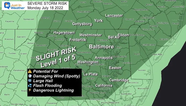
Watch: This will be issued when conditions support ‘potential’ for severe storms. Like a broad area for 6 PM.
Warning: This will be issued when a severe storm, flooding, or tornado is spotted. This will be tracked with towns in the path over specific time frame.
Reminder: This is a ‘suggestion’ not a promise. We have seen storms develop earlier than shown AND with more coverage. I will follow up with an update later this morning.
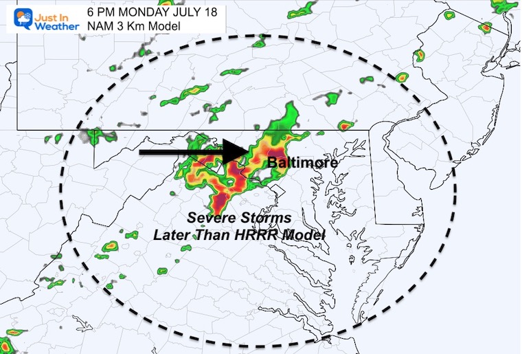
I would plan for the strongest storms any time AFTER 3 PM (earlier than models show below).
In the evening, the line may stall for a few hours, leading reacting storm cells over the same areas and flash flooding in parts of central Maryland.


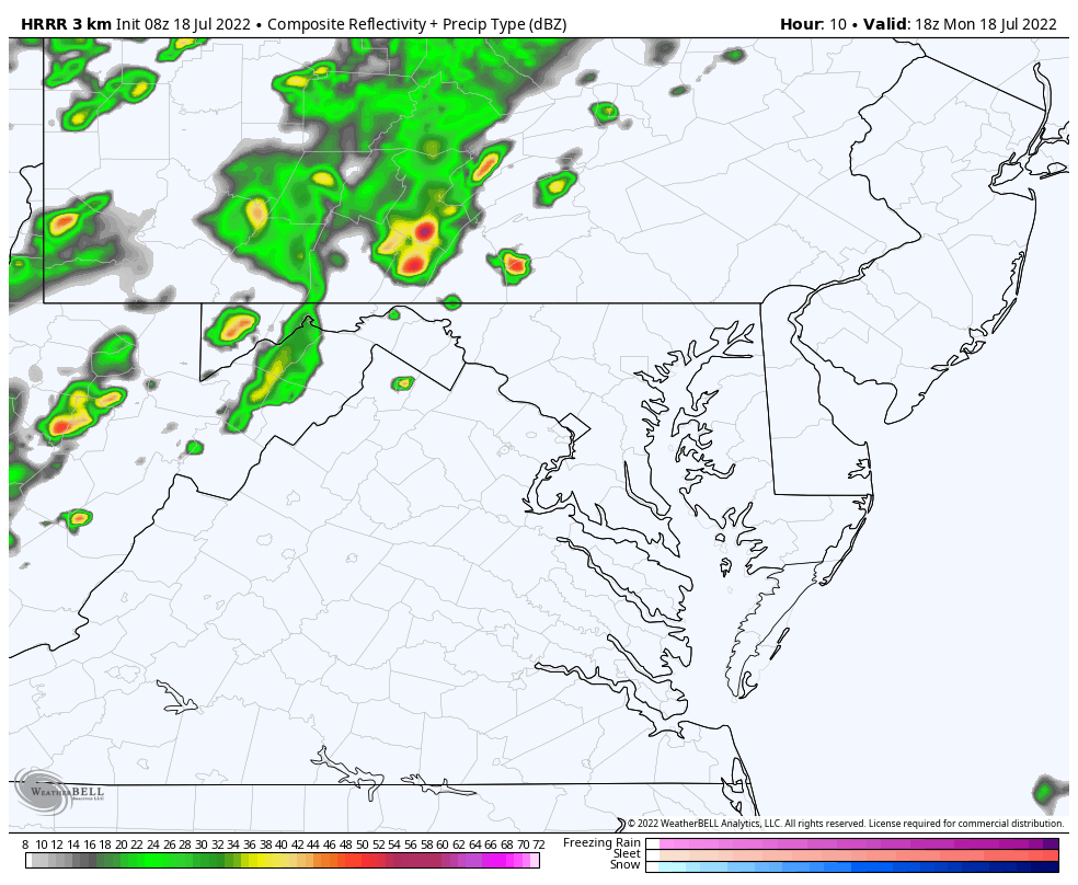
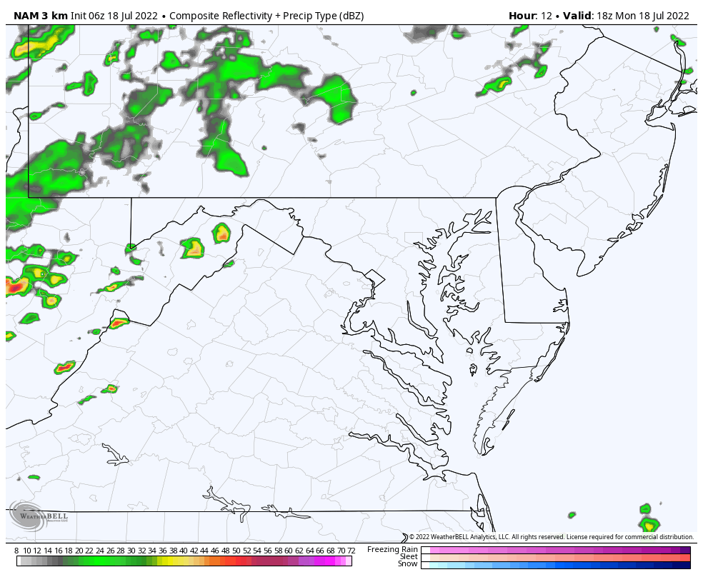
This is later than the HRRR Model but pushes farther south and east.
Here we see the leading cluster just west of Baltimore. It is likely to validate a little earlier than this.
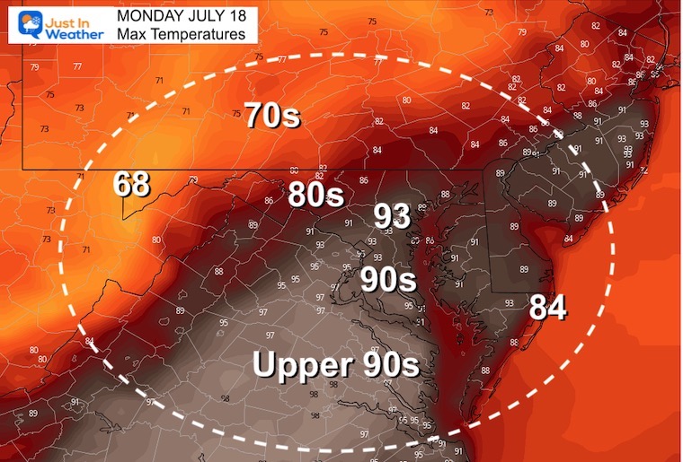
Normal Low in Baltimore: 67ºF
Record 57ºF in 2014
Normal High in Baltimore: 88ºF
Record 104ºF 2012
Clouds should be departing/clearing through the afternoon.
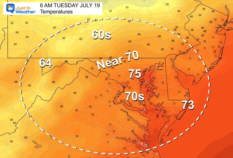
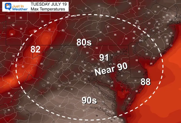
This will be our first true heat wave of the summer! Notice the morning LOW TEMPERATURES remain in the mid to upper 70s. That is a signal of how humid it will feel all week.
Storm Reports (preliminary) : Tuesday July 12
Was there a tornado? Here are my reports.
Still no formal statement from The National Weather Service
July 12 Severe Storm Radar Scans: Was There A Tornado Or Not?

NOAA 2022 Hurricane Forecast- Above Normal Again


NOAA Study: Reducing Air Pollution INCREASED Tropical Storms

Atlantic Tropical History: Maps of Origin Regions Every 10 Days


May 16 Large Hail Videos And Storm Tracking Map


*Disclaimer due to frequent questions:
I am aware there are some spelling and grammar typos. I have made a few public statements over the years, but if you are new here you may have missed it:
I have dyslexia, and found out at my second year at Cornell. I didn’t stop me from getting my meteorology degree, and being first to get the AMS CBM in the Baltimore/Washington region.
I do miss my mistakes in my own proofreading. The autocorrect spell check on my computer sometimes does an injustice to make it worse.
All of the maps and information are accurate. The ‘wordy’ stuff can get sticky.
There is no editor that can check my work when I need it and have it ready to send out in a newsworthy timeline.
I accept this and perhaps proves what you read is really from me…
It’s part of my charm.