The severe weather outbreak on Saturday July 2 crossed Maryland with a vengeance. It carried intense lightning, large hail, tree damage, and extremely heavy rain.
The Flash Flooding occurred in pockets, which is often the case. The result it often some getting too much while others claim they barely got a drop.
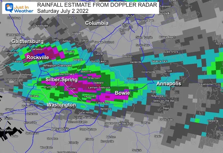
Top spots were in the top of the Washington Beltway were OVER 5” fell on a few locations in Montgomery and Prince George’s Counties in Maryland!
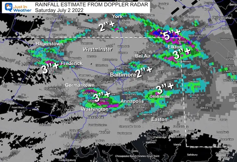
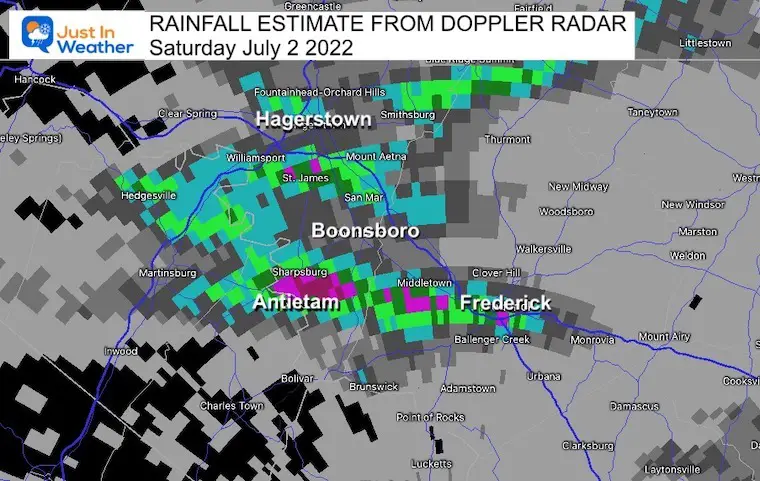
Here is a recap of the rainfall reports across Maryland and metro Washington DC from the National Weather Service. I have cross reference these with Doppler Radar (zoomed in) estimated rainfall.
Rainfall Reports From NWS Baltimore/Washington (LWX)
*********STORM TOTAL RAINFALL (AT LEAST 1.00 INCH)**********
LOCATION TOTAL TIME/DATE COMMENTS RAINFALL MEASURED (inches)
DISTRICT OF COLUMBIA
Washington 5 NW 3.41 800 AM 7/03 CoCoRaHS
Washington 3 NE 2.90 700 AM 7/03 CoCoRaHS
Catholic University 2.74 815 AM 7/03 URBANET
Dalecarlia Reservoir 2.25 800 AM 7/03 Co-Op Observer
National Arboretum 1.90 800 AM 7/03 Co-Op Observer
Takoma Park 1 SW 1.72 825 AM 7/03 AWS
Washington 1.70 748 AM 7/03 CWOP
Adams Morgan 1.67 825 AM 7/03 URBANET
WASHINGTON DC SUBURBS
MARYLAND
…Montgomery County…
Takoma Park 1 NNW 5.22 630 AM 7/03 CoCoRaHS
White Oak 4.04 205 AM 7/03 CWOP
Silver Spring 7 N 3.81 700 AM 7/03 CoCoRaHS
Aspen Hill 1 SW 3.67 844 AM 7/03 Trained Spotter
Silver Spring 3.65 815 AM 7/03 CWOP
Aspen Hill 1 E 3.55 805 AM 7/03 AWS
Norbeck 1 ESE 3.53 700 AM 7/03 CoCoRaHS
Colesville 2 W 3.21 700 AM 7/03 CoCoRaHS
Chevy Chase 3.17 823 AM 7/03 URBANET
Silver Spring 6 NNE 3.03 433 AM 7/03 CoCoRaHS
ROCKVILLE 2.96 817 AM 7/03 CWOP
Rockville 2 W 2.75 825 AM 7/03 AWS
Rockville 1 SE 2.47 700 AM 7/03 CoCoRaHS
Cabin John 2.31 818 AM 7/03 CWOP
Somerset 2.25 824 AM 7/03 AWS
Gaithersburg 2.23 818 AM 7/03 CWOP
Silver Spring 6 N 2.13 700 AM 7/03 CoCoRaHS
Rockville 1 NNW 1.86 825 AM 7/03 AWS
Fairland 1.85 824 AM 7/03 AWS
Silver Spring 2 NNE 1.59 800 AM 7/03 CoCoRaHS
Aspen Hill 2 SE 1.47 808 AM 7/03 CWOP
Potomac 1.39 145 AM 7/03 CWOP
OLNEY 1.38 806 AM 7/03 CWOP
Potomac 3 NE 1.26 700 AM 7/03 CoCoRaHS
Kensington 1.08 825 AM 7/03 URBANET
Garrett Park 1 WSW 1.04 825 AM 7/03 URBANET
…Prince Georges County…
Brentwood 5.95 800 AM 7/03 IFLOWS
Hyattsville 1 N 5.71 700 AM 7/03 CoCoRaHS
Langley Park 1 E 4.77 155 AM 7/03 IFLOWS
Bladensburg 1 NW 4.46 155 AM 7/03 IFLOWS
Beltsville 4.25 815 AM 7/03 CWOP
College Park 1 E 4.16 155 AM 7/03 IFLOWS
Beltsville 1 NNW 3.51 830 AM 7/03 CoCoRaHS
Greenbelt 1 W 3.00 825 AM 7/03 AWS
Glenn Dale 2 W 2.94 825 AM 7/03 AWS
Bladensburg 2.82 825 AM 7/03 URBANET
Bowie 2 NNE 2.77 800 AM 7/03 CoCoRaHS
Bowie 2.59 824 AM 7/03 AWS
Glenarden 1 SSW 2.53 755 AM 7/03 URBANET
Calverton 2.51 825 AM 7/03 AWS
New Carrollton 2 NE 2.39 300 AM 7/03 ALERT
Kettering 3 E 1.88 805 AM 7/03 ALERT
Beltsville 1 NE 1.84 800 AM 7/03 ALERT
New Carrollton 1 ESE 1.75 825 AM 7/03 AWS
Kenilworth 1.72 825 AM 7/03 URBANET
Laurel 1.69 745 AM 7/03 CWOP
Bowie 4 S 1.69 730 AM 7/03 CoCoRaHS
Seat Pleasant 1 E 1.62 825 AM 7/03 AWS
Bowie 3 SSE 1.38 825 AM 7/03 AWS
…Howard County…
Florence 3 S 4.30 800 AM 7/03 Co-Op Observer
Ellicott City 2 E 1.59 800 AM 7/03 ALERT
Ellicott City 2 S 1.28 800 AM 7/03 ALERT
…Anne Arundel County…
Pasadena 3 ESE 2.12 800 AM 7/03 CoCoRaHS
Arnold 1 SE 2.08 800 AM 7/03 Trained Spotter
Annapolis Naval 1.97 754 AM 7/03 ASOS
Crofton 1 SSE 1.79 700 AM 7/03 CoCoRaHS
Edgewater 1.61 815 AM 7/03 CWOP
Severna Park NW 1.51 730 AM 7/03 Trained Spotter
CROFTON 1.51 815 AM 7/03 CWOP
Severna Park 1.49 820 AM 7/03 CWOP
Riva 1.38 815 AM 7/03 CWOP
Pasadena 1.38 145 AM 7/03 CWOP
Annapolis 1.30 815 AM 7/03 CWOP
Davidsonville 1.01 816 AM 7/03 CWOP
Across the Bridge there was heavier rain *under the NWS PHL Office
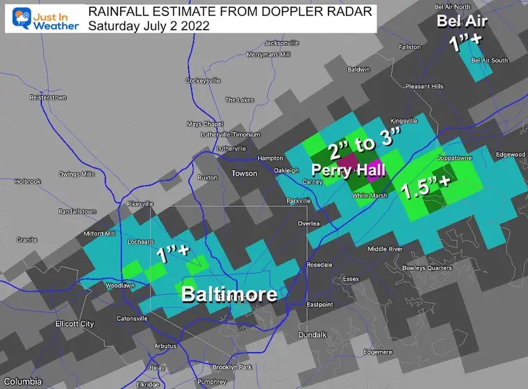
…Baltimore County…
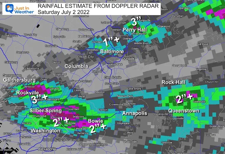
Woodlawn 1 SE 2.73 700 AM 7/03 UCOOP
Perry Hall 2.38 813 AM 7/03 CWOP
White Marsh 2 ESE 2.30 700 AM 7/03 CoCoRaHS
Catonsville 1.36 752 AM 7/03 CWOP
Carney 1.29 825 AM 7/03 URBANET
Middle River 1 WNW 1.10 825 AM 7/03 AWS
Catonsville 1 NNW 1.09 800 AM 7/03 CoCoRaHS
…Baltimore City…
Hamilton NE 1.25 600 AM 7/03 CoCoRaHS
..Harford County…
Edgewood 1.16 748 AM 7/03 CWOP
NORTHEASTERN MARYLAND
…Cecil County...
Elkton 7 NNW 1.70 800 AM 7/03 CoCoRaHS
Elkton 5 NW 1.61 712 AM 7/03 CoCoRaHS
Elkton 1.52 817 AM 7/03 CWOP
Note: Doppler Radar shows spots over 3” that did not have observation posts. This included between Chesapeake City and Cecilton. Also, north of Rising Sun and along the Pennsylvania side of the border.
The big winner was in Lancaster County near Little Britain where 5 to 6 inches of rain fell.

FRONT RANGE
…Frederick County…
Frederick 1 SW 1.19 810 AM 7/03 CoCoRaHS
..Washington County…
Hagerstown 2.15 815 AM 7/03 CWOP
Boonsboro 1.50 813 AM 7/03 CWOP
Smithsburg 1.31 816 AM 7/03 CWOP
Williamsport 3 ENE 1.25 600 AM 7/03 CoCoRaHS
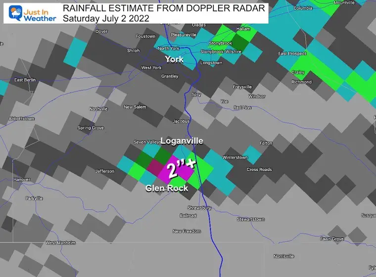
York County PA
One storm cell flared up around I-83 with the peak between Glen Rock and Loganville.
VIRGINIA
…Arlington County…
Arlington 1.30 814 AM 7/03 CWOP
…Loudoun County…
Leesburg 1.20 825 AM 7/03 AWS
WEST VIRGINIA
…Berkeley County…
Hedgesville 3 S 1.96 600 AM 7/03 IFLOWS
Martinsburg 3 SE 1.52 800 AM 7/03 CoCoRaHS
…Jefferson County…
Shepherdstown 3.37 815 AM 7/03 CWOP
Preliminary Storm Report Map
There were a lot of damage reports. Today is the day The National Weather Service will investigate damage to determine if there were any tornado touchdowns.
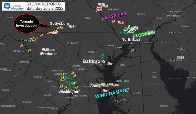
Gettysburg PA
This has gotten a lot of attention and may be top on the list to get explored today.
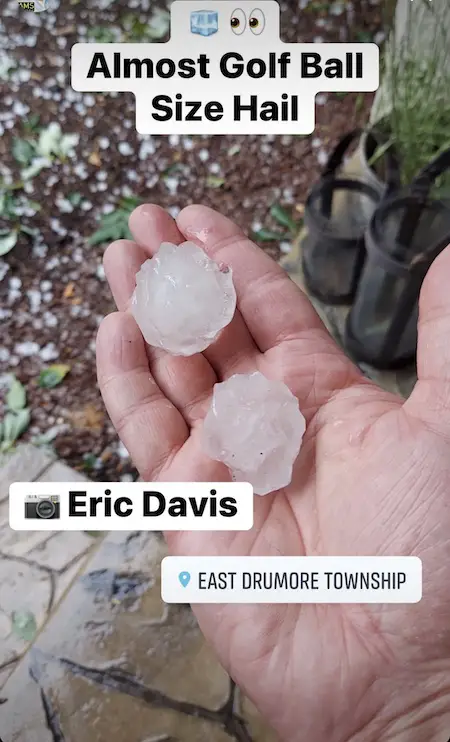
Large Hail was seen in this area up to the site of Golf Balls!
I do hope you were on my Facebook page to see this update Saturday evening when I realized what was about to transpire. I posted this at 7:30 PM
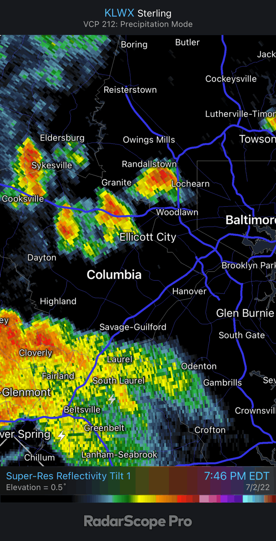
This radar loop from 7:45 PM to 8:15 PM showed the explosive development over Howard County to Baltimore City.
The Lightning Display of Baltimore City was only matched by Flash Flooding and Tornado Warnings even up to Cecil County.
Additional Lighting Photos
It Is Paddling Season

Book Your Kayak or Paddle Boat Adventure On The North Chesapeake Bay
Hurricane Season Forecast: June 1 Through November 30
NOAA 2022 Hurricane Forecast- Above Normal Again

Forecast From Colorado State University
Atlantic Hurricane Forecast

Related Posts
NOAA Study: Reducing Air Pollution INCREASED Tropical Storms

Atlantic Tropical History: Maps of Origin Regions Every 10 Days


Recent Storm Reports
May 22 Hail And Wind Damage

May 16 Large Hail Videos And Storm Tracking Map


Please share your thoughts, best weather pics/video, or just keep in touch via social media
*Disclaimer due to frequent questions:
I am aware there are some spelling and grammar typos. I have made a few public statements over the years, but if you are new here you may have missed it:
I have dyslexia, and found out at my second year at Cornell. I didn’t stop me from getting my meteorology degree, and being first to get the AMS CBM in the Baltimore/Washington region.
I do miss my mistakes in my own proofreading. The autocorrect spell check on my computer sometimes does an injustice to make it worse.
All of the maps and information are accurate. The ‘wordy’ stuff can get sticky.
There is no editor that can check my work when I need it and have it ready to send out in a newsworthy timeline.
I accept this and perhaps proves what you read is really from me…
It’s part of my charm.


