Conditions: Baltimore, Maryland, 04/24/2024 03:50:03 pm
Temperature

74°

Partly Cloudy

40°

Dew Point
Relative Humidity

29%

Feels Like

74°

Wind (WNW)

13mph

Air Pressure

29.91

Sun
Sun Rise

06:16 AM

Sun Set

07:53 PM

Day Length

13:37 Hours

Difference

2 min 19 sec gain

Moon
Moon Rise

08:56 PM

Moon Set

06:23 AM

Next: Last Quarter

May 01,2024

Moon Phase

Full Moon

Climate
Average Low

45°

68°

Average High
Record Low

32°


(2003)

93°


(1960)
Record High
Conditions

Severe Thunderstorm Watch Until 9 PM Plus Local Flooding

Maryland Weather
National Weather Service
Severe Weather
Warnings

July 2 2022

Saturday Afternoon Update

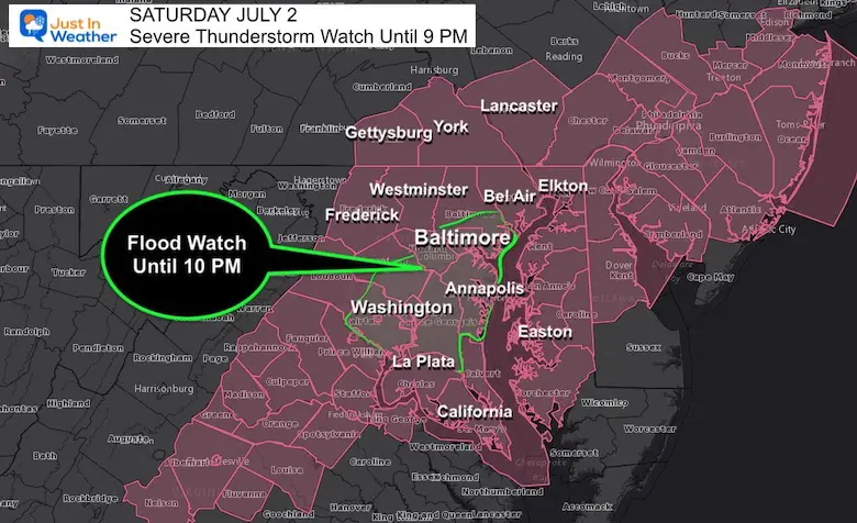
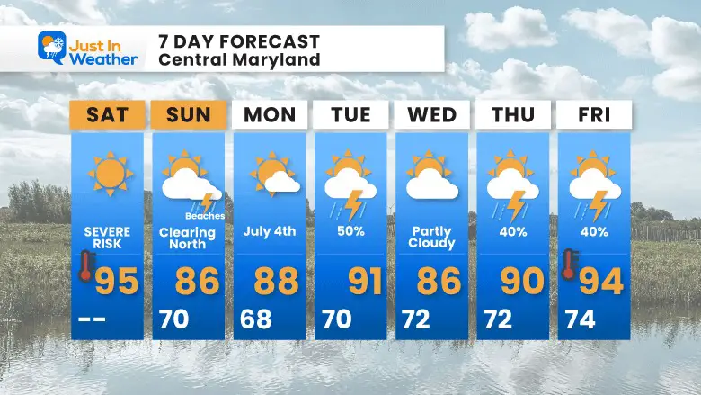
Here we go again, but this was expected. A Severe Thunderstorm Watch has been posted for most of our region until 9 PM. In addition to that a Flood Watch has been issued for Central Maryland until 10 PM. This is because some storms may produce 1 to 3 inches of rain and lead to Flash Flooding.

This does bring heightened attention to Ellicott City for flooding. I also want to draw attention to Northeastern Maryland, mainly Cecil County through Northern Delmarva. The region may be in the path for multiple strength severe storm cells through the afternoon and tonight.

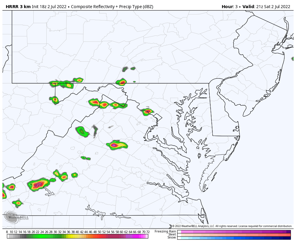
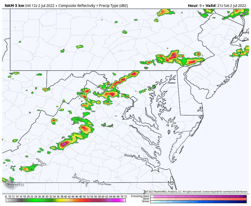
In this post you will see the latest Watch Area, Compare Two Model Radar Simulations (both animation and sliders), and Live Lightning and Radar Widget.

I continue to have low confidence in the short range guidance models. However, within this short time frame, there is a general idea of this:

  • 6 PM and 10 PM: Metro areas (Frederick, York, Westminster, Ellicott City, Baltimore, Bel Air) get most stormy.
  • After Midnight: The front stalls with storms redeveloping between Baltimore, Annapolis, and central Delmarva. 
  • Sunday Morning: Lingering showers, with more storms through the day around Ocean City. 


Alert Reminder:

Watch – (may happen) – This means potential for storms to turn severe or flooding is likely. This is usually issued first for a broad areas and over the course of 6 hours or longer.

Warning – (happening now) – This is when a storm is occurring with those conditions. A shorter time frame with more specific towns and counties will be named.


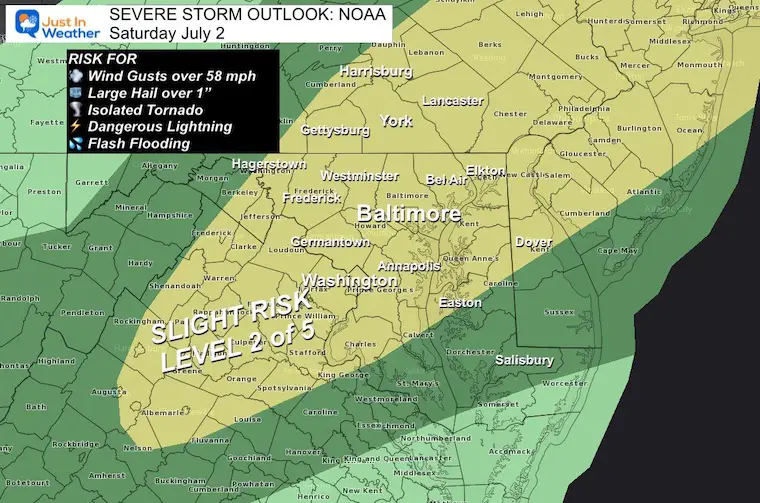
Storms may contain winds over 58 mph, hail over 1″ diameter, and isolated tornadoes.

They are more likely to have dangerous lightning and or flash flooding.


Severe Thunderstorm Watch

This was issued by the National Weather Service.


Counties Included are:

Maryland

ANNE ARUNDEL         BALTIMORE           CALVERT

CAROLINE             CARROLL             CECIL

CHARLES              DORCHESTER          FREDERICK

HARFORD              HOWARD              KENT

MONTGOMERY           PRINCE GEORGES      QUEEN ANNE`S

ST. MARYS            TALBOT


Pennsylvania 

ADAMS                BUCKS               CHESTER

DELAWARE             LANCASTER           MONTGOMERY

PHILADELPHIA         YORK


Virginia

ALEXANDRIA           CHARLOTTESVILLE     FAIRFAX

FALLS CHURCH         FREDERICKSBURG      MANASSAS

MANASSAS PARK


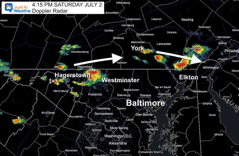
4:15 PM Doppler Radar Snapshot

Here was the radar view I saw as I came in from my training today.

The storms were firing up, what appeared to be earlier than model guidance.


Short Range Models

HRRR Model —> slider 5 PM to Midnight

july-2-weather-storm-radar-hrrr-pm-5
july-2-weather-storm-radar-hrrr-pm-6
july-2-weather-storm-radar-hrrr-pm-7
july-2-weather-storm-radar-hrrr-pm-8
july-2-weather-storm-radar-hrrr-pm-9
july-2-weather-storm-radar-hrrr-pm-10
july-2-weather-storm-radar-hrrr-pm-11
july-2-weather-storm-radar-hrrr-sunday-am-12
previous arrow
next arrow

Radar Animation Simulation 

5 PM to 4 AM

July-2-weather-radar-storm-saturday-hrrrr


NAM Model —> slider 5 PM to Midnight

july-2-weather-storm-radar-nam-pm-5
july-2-weather-storm-radar-nam-pm-6
july-2-weather-storm-radar-nam-pm-7
july-2-weather-storm-radar-nam-pm-8
july-2-weather-storm-radar-nam-pm-9
july-2-weather-storm-radar-nam-pm-10
july-2-weather-storm-radar-nam-pm-11
july-2-weather-storm-radar-nam-sunday-am-12
previous arrow
next arrow


Radar Animation Simulation 

5 PM to 8 AM


July-2-weather-radar-storm-saturday-nam


Live Radar and Lightning Widget


From Earlier Today

Severe Storm Outlook from NOAA

It Is Paddling Season


TEACHER SPECIAL Click Here

$20 Off 2 hour Rental

Book Your Kayak or Paddle Boat Adventure On The North Chesapeake Bay


7 Day Forecast

After storms that may turn severe on Saturday, it will be followed by a cooler Sunday. The July 4th- Monday should heat up again, but remain dry.

Another round of strong to severe storms is possible on Tuesday.


Hurricane Season Forecast: June 1 Through November 30

NOAA 2022 Hurricane Forecast- Above Normal Again


Forecast From Colorado State University

Atlantic Hurricane Forecast


Related Posts


NOAA Study: Reducing Air Pollution INCREASED Tropical Storms


Atlantic Tropical History: Maps of Origin Regions Every 10 Days

13_Tropical Storm Formation Sep11_20


Recent Storm Reports

May 22 Hail And Wind Damage

May 16 Large Hail Videos And Storm Tracking Map


Please share your thoughts, best weather pics/video, or just keep in touch via social media

Facebook: Justin Berk, Meteorologist

Twitter: @JustinWeather

Instagram: justinweather


*Disclaimer due to frequent questions:

I am aware there are some spelling and grammar typos. I have made a few public statements over the years, but if you are new here you may have missed it:

I have dyslexia, and found out at my second year at Cornell.  I didn’t stop me from getting my meteorology degree, and being first to get the AMS CBM in the Baltimore/Washington region. 

I do miss my mistakes in my own proofreading. The autocorrect spell check on my computer sometimes does an injustice to make it worse. 

All of the maps and information are accurate. The ‘wordy’ stuff can get sticky. 

There is no editor that can check my work when I need it and have it ready to send out in a newsworthy timeline. 

I accept this and perhaps proves what you read is really from me…

It’s part of my charm.