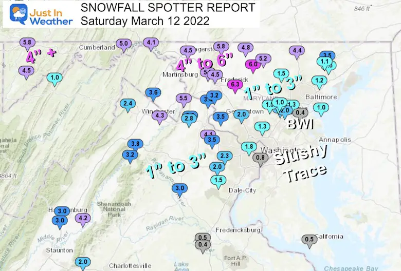
The following are maps and list of reports from snow spotters to the National Weather Service. There are gaps and perhaps numbers that don’t match what you had by you, but this the best we have at this time.
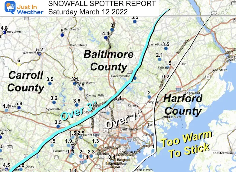
There was a big jump from a slushy trace along many water locations, Metro locations between 1 to 3 inches, then higher amounts farther inland. The big winners locally were where the Winter Storm Warning was expanded this morning. This is where over 4 inches of snow fell in Northern Baltimore County, Carroll, Frederick, and westward.
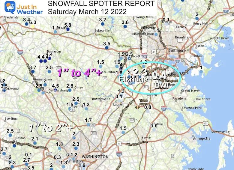
Elevation and proximity away from the water played a big role in snowfall. Here was can see just a little inland from the Bay and snowfall amounts jumped.
First the maps, then the list of individual reports…
Baltimore’s Official Report
Baltimore’s BWI reported a total precipitation of 0.69”.
But adding up the hourly reports with snow since 8:28 AM = 0.32”. Under normal condition that would have translated to 3 inches of snow. But due to melting, only 0.4” snow was reported at the airport. A lot of snow fell and melted on the warmer ground.
Compare that to Elkridge just a couple of miles away and the snow report was 2.3”. That has been the case much of this winter… making many wonder if BWI Airport is an artificially warmed location, or simply just luck of the geographical draw?
Just inland across much of Howard and Montgomery Counties there was a wide range of 1 to 4 inches of snowfall.
Central Maryland:
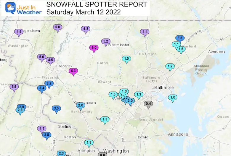
Closer Look At Metro Baltimore
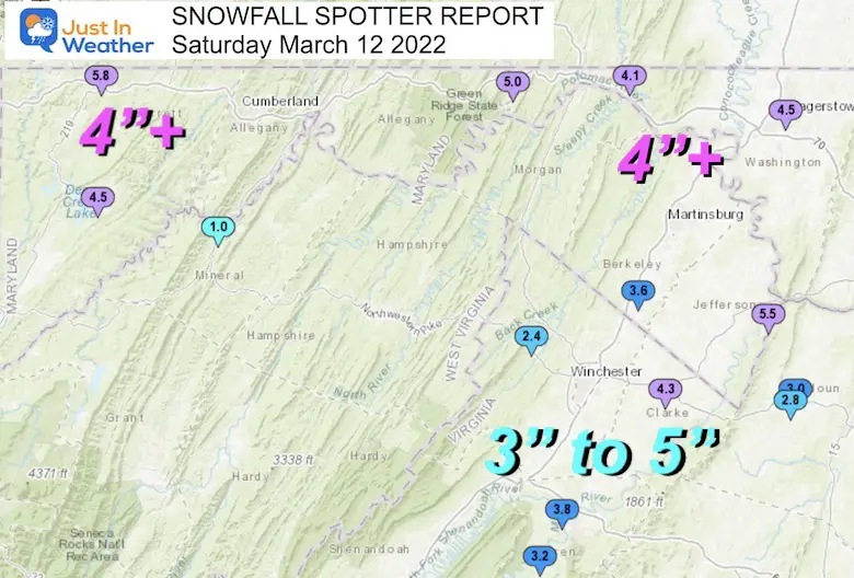
Western Maryland
Most of the mountainous region got over 4 inches. However there was a lower (expected) range around 1 inch or so, that included the Cumberland Valley.
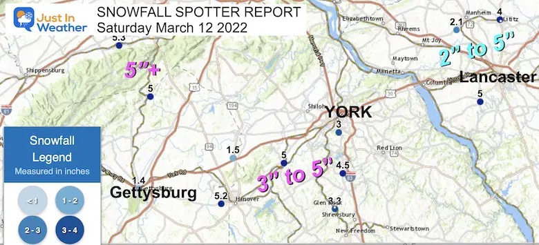
Southern Pennsylvania
An average of 3 to 5 inches in the region.
Snow Reports From NWS Baltimore/Washington
**********STORM TOTAL SNOWFALL (AT LEAST 0.1 INCH)**********
LOCATION TOTAL TIME/DATE COMMENTS
SNOWFALL MEASURED
(inches)
DISTRICT OF COLUMBIA
…District of Columbia…
National Zoo 1 WSW 2.3 435 PM 3/12 Trained Spotter
MARYLAND
…Allegany County…
Bellegrove 1 SSE 5.0 107 PM 3/12 Trained Spotter
Frostburg 4.0 434 PM 3/12 Trained Spotter
Frostburg 2 ENE 2.0 556 PM 3/12 Trained Spotter
…Anne Arundel County…
Odenton 1 WNW 0.8 316 PM 3/12 Trained Spotter
Crofton 1 SSE 0.6 303 PM 3/12 NWS Employee
Bwi Airport 0.4 100 PM 3/12 Airport
…Baltimore County…
Parkton 1 W 4.4 1235 PM 3/12 Trained Spotter
Randallstown 2 NW 3.6 407 PM 3/12 Trained Spotter
Reisterstown 1 ESE 3.5 440 PM 3/12 Trained Spotter
Glyndon 1 WSW 3.4 400 PM 3/12 Trained Spotter
Long Green 2 NW 3.0 500 PM 3/12 Trained Spotter
Bentley Springs 1 E 3.0 1200 PM 3/12 Trained Spotter
Perry Hall 1 NNE 2.0 500 PM 3/12 Trained Spotter
Glyndon 1 SW 2.0 505 PM 3/12 Trained Spotter
Catonsville 1 SSE 1.3 1230 PM 3/12 Trained Spotter
Edgemere ESE 1.0 250 PM 3/12 Trained Spotter
…Baltimore City…
Pimlico SE 1.1 300 PM 3/12 Trained Spotter
...Calvert County…
Prince Frederick 1 S 0.1 350 PM 3/12 Trained Spotter
…Carroll County…
New Windsor 1 ENE 6.0 230 PM 3/12 NWS Employee
Watersville 1 N 6.0 1125 AM 3/12 Trained Spotter
Westminster SE 5.2 225 PM 3/12 Trained Spotter
Manchester 1 SSW 5.0 400 PM 3/12 Trained Spotter
Taneytown NW 4.8 230 PM 3/12 Trained Spotter
Taneytown NE 4.2 1200 PM 3/12 Trained Spotter
Columbia 2 NNE 4.0 300 PM 3/12 Trained Spotter
Gamber 1 WNW 3.5 514 PM 3/12 CoCoRaHS
Eldersburg 1 SE 3.2 1130 AM 3/12 Trained Spotter
…Frederick County…
New Market N 6.3 230 PM 3/12 Trained Spotter
Thurmont 3 N 5.8 245 PM 3/12 NWS Employee
Myersville 2 SE 5.0 1230 PM 3/12 Trained Spotter
Bloomfield 2 WSW 4.5 1210 PM 3/12 NWS Employee
Point of Rocks 1 NE 3.4 230 PM 3/12 Trained Spotter
Buckeystown 3 SW 3.2 1231 PM 3/12 NWS Employee
Adamstown 1 ESE 2.8 1200 PM 3/12 NWS Employee
Ballenger Creek WSW 2.5 1100 AM 3/12 Trained Spotter
Jefferson NE 2.2 630 PM 3/12 Trained Spotter
…Garrett County…
Grantsville 7 WNW 7.7 330 PM 3/12 Trained Spotter
Grantsville 5 W 6.3 609 PM 3/12 Dept of Highways
Deer Park 6 NE 4.5 200 PM 3/12 Trained Spotter
…Harford County…
Forest Hill 1 NNW 3.5 255 PM 3/12 Trained Spotter
Norrisville 1 WSW 3.5 315 PM 3/12 CoCoRaHS
Forest Hill 3 SW 2.1 530 PM 3/12 Trained Spotter
Bel Air 2 W 1.5 128 PM 3/12 Trained Spotter
…Howard County…
Woodstock 2 SW 3.5 430 PM 3/12 Trained Spotter
Ellicott City 2.5 441 PM 3/12 Broadcast Media
Elkridge 2.3 629 PM 3/12 NWS Employee
Columbia 1 ENE 2.0 200 PM 3/12 Trained Spotter
Elkridge 2 W 2.0 310 PM 3/12 Trained Spotter
Columbia 2 N 1.9 345 PM 3/12 Trained Spotter
Columbia 1.5 400 PM 3/12 NWS Employee
Clarksville 2 N 1.5 100 PM 3/12 Trained Spotter
Savage 1 WSW 1.3 1200 PM 3/12 Trained Spotter
Elkridge 2 SW 1.1 1045 AM 3/12 Trained Spotter
Ellicott City 1 SW 1.0 120 PM 3/12 Trained Spotter
…Montgomery County…
Washington Grove 1 N 4.5 305 PM 3/12 Trained Spotter
Damascus 3 SSW 4.4 445 PM 3/12 Co-Op Observer
Damascus 1 SE 4.4 520 PM 3/12 Trained Spotter
Damascus 1 S 4.4 1205 PM 3/12 Trained Spotter
Clarksburg 1 SSE 3.7 1200 PM 3/12 Trained Spotter
Poolesville NE 3.5 145 PM 3/12 Trained Spotter
Olney 2.8 400 PM 3/12 NWS Employee
Laytonsville 2 WNW 2.5 615 PM 3/12 Trained Spotter
Gaithersburg 1 WNW 2.5 245 PM 3/12 CoCoRaHS
Norbeck 1 ESE 2.5 330 PM 3/12 Trained Spotter
Somerset 1 ENE 2.0 1130 AM 3/12 Trained Spotter
Montgomery Village 1 2.0 100 PM 3/12 Trained Spotter
Four Corners 1 ESE 1.7 1200 PM 3/12 Trained Spotter
Aspen Hill 1 SW 1.5 315 PM 3/12 Trained Spotter
Colesville 1.3 120 PM 3/12 Trained Spotter
…Prince Georges County…
Glenn Dale 2 WNW 1.5 500 PM 3/12 NWS Employee
…St. Marys County…
California 2 W 0.6 415 PM 3/12 Trained Spotter
Callaway 2 W 0.5 258 PM 3/12 Trained Spotter
California 3 W 0.4 500 PM 3/12 Trained Spotter
Hollywood 3 S 0.2 340 PM 3/12 Trained Spotter
…Washington County…
Sabillasville 2 NNW 6.5 642 PM 3/12 CoCoRaHS
Hagerstown 4.5 222 PM 3/12 Dept of Highways
Boonsboro 3 NNE 4.4 200 PM 3/12 Trained Spotter
Pecktonville 3 NNW 4.1 220 PM 3/12 NWS Employee
Hancock 1 ESE 3.5 300 PM 3/12 Trained Spotter
VIRGINIA
…Albemarle County…
Crozet 1 W 2.0 140 PM 3/12 Trained Spotter
…Arlington County…
Baileys Crossroads 1 1.3 1055 AM 3/12 Trained Spotter
Rosslyn 1 S 1.2 1200 PM 3/12 Trained Spotter
Rosslyn 1 WSW 0.9 530 PM 3/12 Trained Spotter
Reagan National Apt 0.8 100 PM 3/12 Airport
…Augusta County…
Fishersville 1 NE 3.8 1100 AM 3/12 Trained Spotter
…City of Fairfax…
Fairfax 1 ESE 3.5 1128 AM 3/12 Trained Spotter
…City of Falls Church…
Lake Barcroft 1 W 2.0 1140 AM 3/12 Trained Spotter
…City of Fredericksburg…
Dunavant 1 S 2.2 300 PM 3/12 Trained Spotter
…City of Manassas…
Manassas Park 1 SW 1.8 415 PM 3/12 Trained Spotter
…Clarke County…
Berryville 1 NNW 5.3 400 PM 3/12 Trained Spotter
…Culpeper County…
Culpeper 1 W 1.0 1106 AM 3/12 Trained Spotter
…Fairfax County…
Reston 1 SSW 3.0 1112 AM 3/12 Trained Spotter
Fairfax 1 N 2.7 305 PM 3/12 NWS Employee
Chantilly 3 N 2.7 247 PM 3/12 NWS Employee
Herndon 1 NNE 2.5 1120 AM 3/12 NWS Employee
Chantilly 2 ESE 2.3 100 PM 3/12 Trained Spotter
Centreville W 2.2 330 PM 3/12 Trained Spotter
Wolf Trap 1 ENE 2.1 500 PM 3/12 CoCoRaHS
Herndon 2 ENE 2.0 1200 PM 3/12 Trained Spotter
Chantilly 2 ENE 2.0 306 PM 3/12 Trained Spotter
Manassas Park 2 E 2.0 1240 PM 3/12 Trained Spotter
Langley 1 SE 1.8 100 PM 3/12 Trained Spotter
West Springfield 2 W 1.8 1144 AM 3/12 Trained Spotter
Franconia 1 SSW 0.9 1115 AM 3/12 Trained Spotter
…Fauquier County…
Opal 3.0 242 PM 3/12 NWS Employee
Opal 1 NW 2.0 1135 AM 3/12 Trained Spotter
Broken Hill 2 E 1.0 1145 AM 3/12 NWS Employee
…Frederick County…
Hayfield 1 N 2.4 133 PM 3/12 Trained Spotter
Stephens City 2 E 1.8 1050 AM 3/12 Trained Spotter
…Loudoun County…
Bloomery 3 ESE 5.5 545 PM 3/12 Trained Spotter
Ashburn 3 WSW 4.1 215 PM 3/12 NWS Employee
Arcola 3 S 3.7 315 PM 3/12 Trained Spotter
Dulles International 3.5 100 PM 3/12 Airport
Purcellville 2 NNE 3.0 201 PM 3/12 Trained Spotter
Hillsboro 3 NW 3.0 1118 AM 3/12 Trained Spotter
Purcellville 2.8 1218 PM 3/12 NWS Employee
Leesburg 2 WSW 2.3 300 PM 3/12 Trained Spotter
…Page County…
Kimball 2 SE 6.3 1140 AM 3/12 Park/Forest Srvc
Honeyville 1 ESE 2.8 348 PM 3/12 Trained Spotter
…Prince William County…
Woolsey 1 SW 3.6 335 PM 3/12 Trained Spotter
Manassas Park 1 NNW 2.5 530 PM 3/12 Trained Spotter
Dale City 1 W 2.4 345 PM 3/12 Trained Spotter
Independent Hill 3 N 2.1 332 PM 3/12 Trained Spotter
…Rockingham County…
Massanutten 1 SE 4.2 115 PM 3/12 Trained Spotter
Dale Enterprise 1 ES 3.0 200 PM 3/12 Trained Spotter
Bridgewater 2 E 3.0 1245 PM 3/12 Trained Spotter
…Spotsylvania County…
Spotsylvania 3 N 2.5 310 PM 3/12 Trained Spotter
Spotsylvania Courtho 0.4 1214 PM 3/12 Trained Spotter
…Stafford County…
Ramoth 1 W 1.2 430 PM 3/12 Trained Spotter
White Oak 3 SSE 0.7 430 PM 3/12 CoCoRaHS
…Warren County…
Riverton 1 WNW 3.8 130 PM 3/12 Trained Spotter
Karo 1 N 3.7 1100 AM 3/12 Trained Spotter
Linden 3 W 3.5 1131 AM 3/12 Trained Spotter
Karo 1 WSW 3.2 130 PM 3/12 Trained Spotter
WEST VIRGINIA
…Berkeley County…
Winebrenners Cross 4 4.5 1107 AM 3/12 Trained Spotter
Martinsburg 2 E 4.0 1100 AM 3/12 NWS Employee
Bunker Hill SE 3.6 1218 PM 3/12 Trained Spotter
…Jefferson County…
Millville 1 ESE 5.5 1242 PM 3/12 Trained Spotter
Bloomery 3 SSE 4.0 1200 PM 3/12 Trained Spotter
…Mineral County…
Keyser 1.0 211 PM 3/12 Trained Spotter
…Pendleton County…
Deer Run 2 WSW 3.0 427 PM 3/12 Trained Spotter
ALSO SEE
ALL FITF GEAR

FITF THUNDERSNOW


Winter Outlook Series:
My Call For Snowfall

Last Winter Recap: My Old Outlook And Your Grades Of My Storm Forecasts


Please share your thoughts, best weather pics/video, or just keep in touch via social media
*Disclaimer due to frequent questions:
I am aware there are some spelling and grammar typos. I have made a few public statements over the years, but if you are new here you may have missed it:
I have dyslexia, and found out at my second year at Cornell. I didn’t stop me from getting my meteorology degree, and being first to get the AMS CBM in the Baltimore/Washington region.
I do miss my mistakes in my own proofreading. The autocorrect spell check on my computer sometimes does an injustice to make it worse.
All of the maps and information are accurate. The ‘wordy’ stuff can get sticky.
There is no editor that can check my work when I need it and have it ready to send out in a newsworthy timeline.
I accept this and perhaps proves what you read is really from me…
It’s part of my charm.
#FITF


