Winter Storm Update: Snow Potential Maps From Models And NWS
March 11 2022
Friday Afternoon Update
I hope you are catching this report after seeing my either my storm post from last night or this morning. My focus here is on the potential snowfall as seen around the main computer model guidance and from the National Weather Service. I have new maps, and the link to see the NWS maps as they get updated.
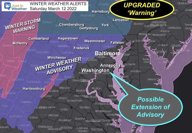
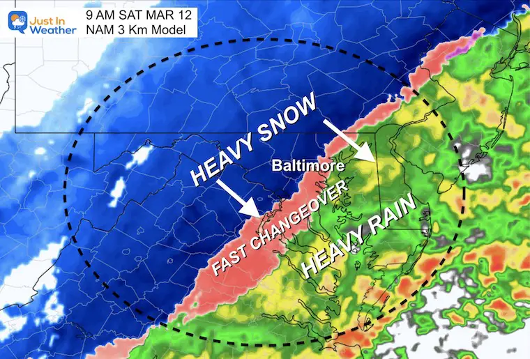
The main storm updates now are an expectation for a faster change over due to temps falling earlier. Also, Southern Pennsylvania has been upgraded to a Winter Storm Warning from a Watch. This was expected.
Before I make a new map, I want to see if any of central Maryland gets upgraded to a Warning or if the Advisory expands farther east and south. I think it might include Baltimore, Washington, and Annapolis, that is up to The National Weather Service.
Quick Reference:
- Winter Storm Warning (pink): Snow 4 to 8 inches
- Winter Weather Advisory (purple): Snow 2 to 4 inches
- Possible Extension Of Advisory: 1 to 3 inches
- If your area is NOT colored in, there may be less stickage, but you still get in on falling snow/wind/and icing potential Saturday evening.
What’s Making This Special?
Let’s disregard the wins and losses from earlier this season. Yes, we can consider that the ground is warm, and the sun angle is high now in mid March. What is working in the favor of winter will be:
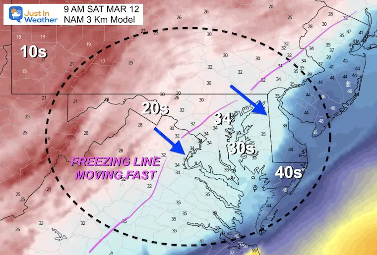
- Rapid Drop Of Temps to FREEZING between 8 AM and 10 AM for the metro areas… Not long after to Southern Maryland and Delmarva.
- Snow will continue to fall at a moderate to heavy pace for a few hours. 1″ per hour rate can overtake the warmer ground.
- Temps will drop into the 20s during the afternoon. A flash freeze on pavement is possible.
- By evening, most of the region will be in the 20s. So what was went should ice up before the wind has a chance to dry it out.
- Sunday morning will remain in the teens and 20s. Due to the Time Change, we lose an hour which means more activities may be affected if there is ice.
EXPLORE MORE:
Click here to see my Morning Report With Timeline Sliders
How Much Snow May Fall?
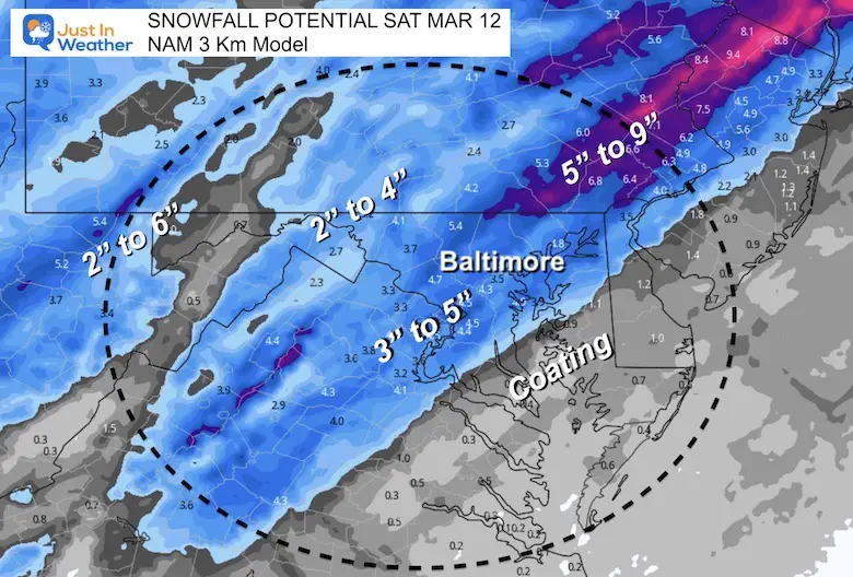
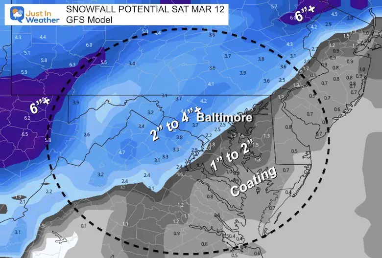
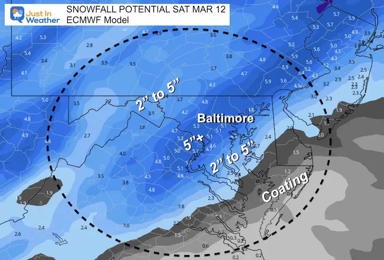
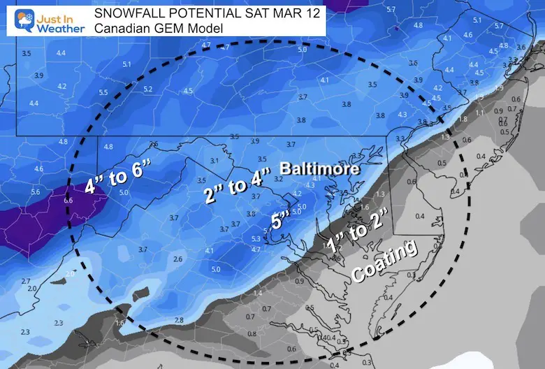
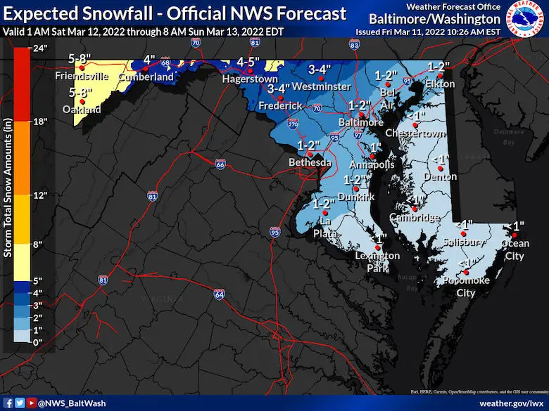
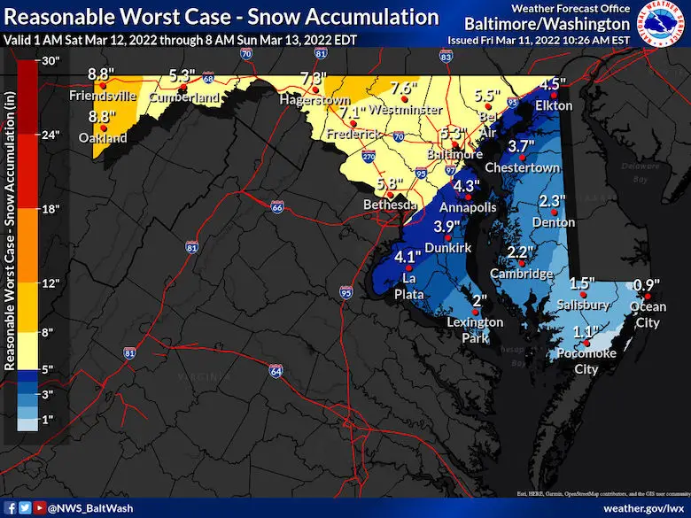
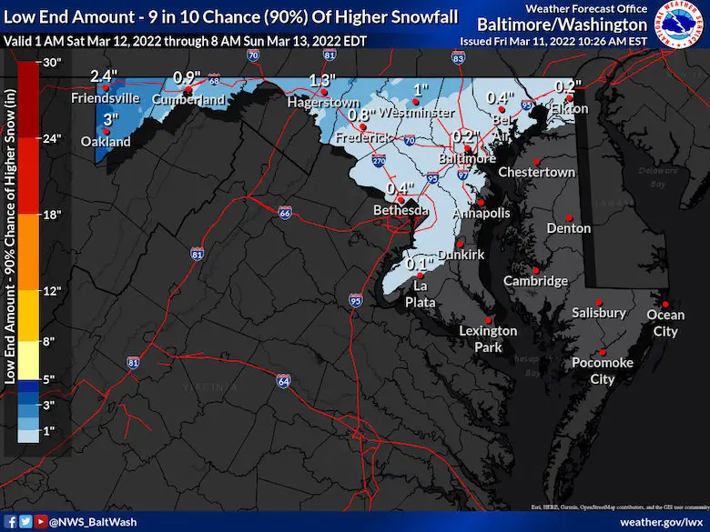
Here is a simply a look at four computer models and the National Weather Service maps for Maryland and Pennsylvania. These include the Exploited Snow, High End, and Low End potential.
These amounts are for what will fall, but we must consider that some will melt.
As for shoveling and plowing I would apply a general rule:
1/2 of these snow map totals for what may lay and stay on pavement to be pushed.
Computer Model Forecasts
NAM 3 Km
GFS Model (lowest snowfall for central MD)
Europea Model
Canadian GEM
National Weather Service Snow Maps
Maryland: Expected, High AND Low End
Click To See:
ALL maps Autoupdated On This Snow Map Page
Expected
High Potential
Lowest Potential
Pennsylvania : Expected, High AND Low End
Expected
Highest Potential

Lowest Potential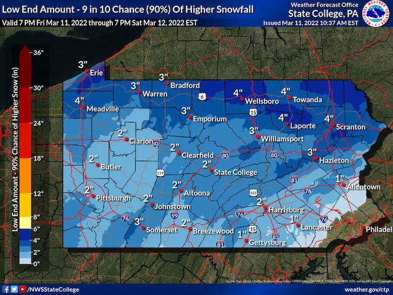
New Jersey
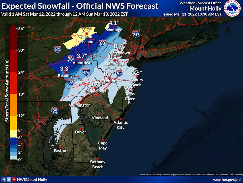
Delaware

I will follow up with any new Advisories and snow info later..
Faith in the Flakes.
Weather posts straight to your inbox
Sign up and be the first to know!
ALSO SEE
What is Faith in the Flakes: History of December 5th Snow
ALL FITF GEAR
FITF THUNDERSNOW
Winter Outlook Series:
Last Winter Recap: My Old Outlook And Your Grades Of My Storm Forecasts
Winter Weather Page – Lots of resources
Solar Cycle Increasing Sunspots Suggests More Snow
Comparing 4 Different Farmer’s Almanacs: Majority colder winter outlook than NOAA
NOAA Winter Outlook- But Read The Fine Print
Signals For Early Start To Winter In November
Winter Outlook Series: La Nina Double Dip
Nor’easters May Give Hint For Winter La Nina Pattern
Winter Folklore Checklist
Please share your thoughts, best weather pics/video, or just keep in touch via social media
Facebook: Justin Berk, Meteorologist
Twitter: @JustinWeather
Instagram: justinweather
*Disclaimer due to frequent questions:
I am aware there are some spelling and grammar typos. I have made a few public statements over the years, but if you are new here you may have missed it:
I have dyslexia, and found out at my second year at Cornell. I didn’t stop me from getting my meteorology degree, and being first to get the AMS CBM in the Baltimore/Washington region.
I do miss my mistakes in my own proofreading. The autocorrect spell check on my computer sometimes does an injustice to make it worse.
All of the maps and information are accurate. The ‘wordy’ stuff can get sticky.
There is no editor that can check my work when I need it and have it ready to send out in a newsworthy timeline.
I accept this and perhaps proves what you read is really from me…
It’s part of my charm.
#FITF


