March 8 2022
Tuesday Evening Update
Stop me if you hear this one before: We hit the 70s and now expecting snow. Oh yes, we did this two weeks ago. On Wed Feb 23, BWI hit 76ºF, the Thu Feb 24 a wet snow fell. But that only totaled a trace. The ground was too warm.
Do you see where I am going with this? I doubt there is going to be a local school delay. I’m sorry. But some places may have low visibility if and when the snow gets heavy.
Our current situation: we have a full day as a buffer between our two record high days in the upper 70s and the snow. Also, it looks like more snow will be likely just west and north of Baltimore. We will talk timeline and stickage below. But keep reading… The following event on Saturday will be larger and more widespread as polar influence does its thing.
Evening Set Up
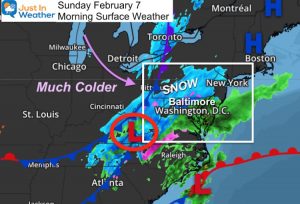
There is it… Low Pressure centered in Georgia will be moving up through Maryland tomorrow morning.
The cold air from the Northern Plains will catch up just in time… well, maybe a couple of hours after it begins.

Radar Simulation
I want to show the HRRR Model since it is the highest resolution and updates most often (hourly) to perform best in short range.
First the Animation then the hourly slider so you can pause.
Animation 2 AM to 11 AM
This shows the expansion of the snow in northern Maryland AFTER beginning as rain. Snow will be more widespread in the mountains and in Pennsylvania.
Heavy Rain will fall in Southern Maryland.
The snow development is forecast to begin around 7 or 8 AM
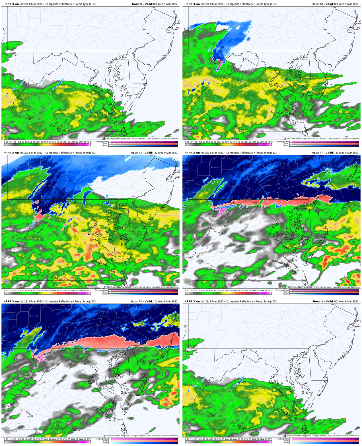
Hourly Timeline —> slider
Notice the snow should expand between 7 AM and 9 AM. This will be during the commute, however the roads should remain wet in metro areas.
Who Will See Snow?
- Yes: The typical colder zone west and north of Baltimore.
- Some Mixing: Baltimore Beltway I expect some mixing for an hour or two. Some slushy coating on grass, landscaping and car tops.
- By The Bay & Near Annapolis: Very little mixing to just all rain.
- Western Maryland: Plenty of snow! Stickage and Moderate Accumulation
- Near the PA Line: Snow for a few hours. Some coating the grass up to 1 inch.
- PA: North of I-76 a better chance for roads to get coated.
- I-81 North of Fort Indiantown Gap may have rough travel though noon. Same up towards the Poconos north of Allentown.
Temperatures
I picked this time when the influence of expanding snow should drop temps to their coldest.
Most of us remain above freezing.
The mountains above 2,000 Ft will drop below freezing and support stickage on their roads.

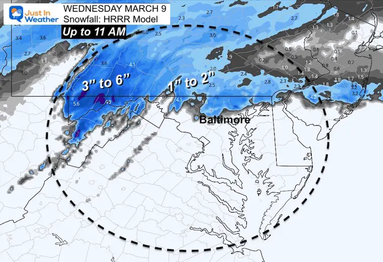
Total Snow Up To 11 AM
This is a reasonable scenario for what will FALL, but not necessarily what will lay, stay, and be measured.
There will be some melting. However where you see ‘blue’ is where them nay at least be a coating on the grass.
Western Maryland could get over 3 inches of new snow on the mountains. Here we see McHenry with 5.6″ possible for Wisp.
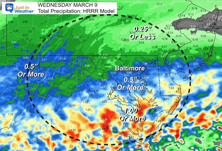
Precipitation Total Up To 11 AM
There will be heavy rain. About 1/2 inch around Baltimore, and over 1 inch in southern Maryland.
Jumping To The Weekend
Here’s the European Model scenario showing the Polar Front Phasing and showing us a new coastal Low helping to work off the cold and bring rain to snow line to the coast.
7 PM Friday to 7 PM Saturday

Closer Look Saturday
ECMWF Model
The European Model is bringing the snow line through central Maryland and across the Bay during the afternoon.
Yes, there will be moderate snow falling.
Yes, temperatures will be dropping through the 30s, and even below freezing before the day ends.
How much may stick? That will be the debate for the rest of the week.

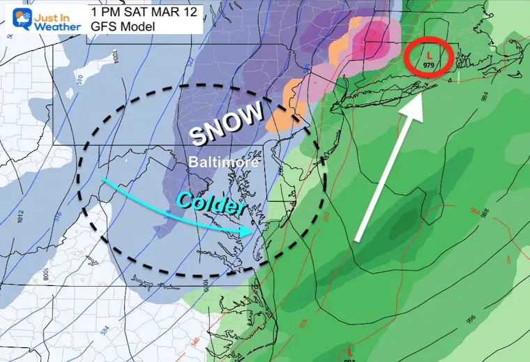
GFS Model
This shows a similar but weaker set up.
For the weather nuts that follow model update, this was the morning (12Z) forecast. The afternoon (18Z) model broke this up, but I do not trust off hour updates…
My Thoughts
I realize we have plenty of time to digest and fine tune our expectations.
If this was in January, it would be a big deal. To see this in March, it is newsworthy AND also could end up more nuisance than disruptive.
The March sun angle and warm ground will battle stickage. But we have had March snow events like the 1993 Superstorm to remind us that it is worth paying attention to for possibly worse. We have actually had two large snow events in March for the northern zones in the last 5 years. I expect the colder areas may very well have some possible travel impact.
So please consider your plans may get impacted, but don’t call them off yet. Stay tuned.
First we get through the event Wednesday as the appetizer.
Faith in the Flakes.
Weather posts straight to your inbox
Sign up and be the first to know!
ALSO SEE
What is Faith in the Flakes: History of December 5th Snow
ALL FITF GEAR
FITF THUNDERSNOW
Winter Outlook Series:
Last Winter Recap: My Old Outlook And Your Grades Of My Storm Forecasts
Winter Weather Page – Lots of resources
Solar Cycle Increasing Sunspots Suggests More Snow
Comparing 4 Different Farmer’s Almanacs: Majority colder winter outlook than NOAA
NOAA Winter Outlook- But Read The Fine Print
Signals For Early Start To Winter In November
Winter Outlook Series: La Nina Double Dip
Nor’easters May Give Hint For Winter La Nina Pattern
Winter Folklore Checklist
Please share your thoughts, best weather pics/video, or just keep in touch via social media
Facebook: Justin Berk, Meteorologist
Twitter: @JustinWeather
Instagram: justinweather
*Disclaimer due to frequent questions:
I am aware there are some spelling and grammar typos. I have made a few public statements over the years, but if you are new here you may have missed it:
I have dyslexia, and found out at my second year at Cornell. I didn’t stop me from getting my meteorology degree, and being first to get the AMS CBM in the Baltimore/Washington region.
I do miss my mistakes in my own proofreading. The autocorrect spell check on my computer sometimes does an injustice to make it worse.
All of the maps and information are accurate. The ‘wordy’ stuff can get sticky.
There is no editor that can check my work when I need it and have it ready to send out in a newsworthy timeline.
I accept this and perhaps proves what you read is really from me…
It’s part of my charm.
#FITF


