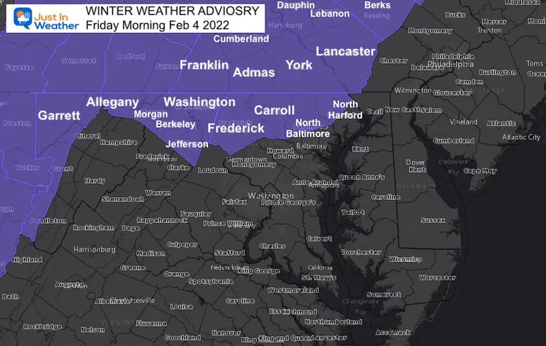
This is a follow up to my report last night that showed the most likely areas to be impacted by ice on Friday morning. The National Weather Service has issued a Winter Weather Advisory for counties in Maryland north and west of Baltimore through Southern Pennsylvania.
This includes the areas I noted as “Likely”, “A Good Chance”, and “On The Bubble” for impact on roads. Compare the maps below.
Winter Weather Advisory
FOR FRIDAY MORNING
This will start as a mild rain, then transition to freezing rain as surface temps cool, but the clouds remain warmer.It will take at least an hour or two below freezing in the dark hours before sunrise for roads to start icing up.
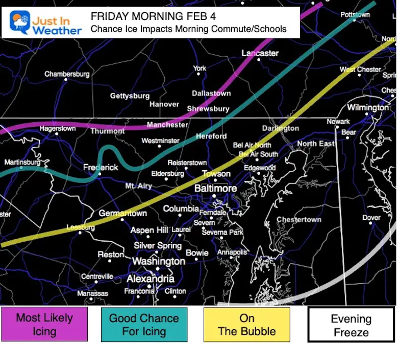
Where Ice Is Likely To Impact Friday Morning
Local View
This is NOT A Promise, but where I believe the ice will establish on the roads to lead to travel concerns.
Explanation
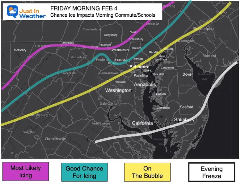
Most Likely Icing On Roads:
Maryland near the Pennsylvania line AND into southern PA to include much of York and perhaps into Lancaster Counties.
Good Chance For Icing:
This depends on the freezing line arriving close to 6 AM, allowing time for the wet roads to freeze.
Hagerstown, North of Frederick (the city tends to stay warmer for longer), Westminster, and Hereford Zone.
On The Bubble:
This area really depends on how far the freezing line can reach before sunrise and ice up the roads. If this NAM 3 Km is too slow and the GFS wins, then these areas are in play:
Germantown, Mt. Airy, Eldersburg, Towson, North Bel Air, Darlington.
Less Likely:
Immediate Baltimore, around the Bay and southward. This includes not an issue for Washington and Annapolis.
Wider View
Timing Is Key!
When an ice event starts with freezing rain or sleet, it is much different than a warm rain turning colder.In this case, we will have temps in the 40s and 50s with rain warming the ground, then turning colder.
That takes time to chill and allow pavement to catch up and ice over.
For any impact on the roads, I would suggest this:
The Freezing Line must arrive by around 6 AM. This allows about 2 hours until the sun angle is high enough in the sky (through the clouds) to help warm the pavement.
Places that drop below freezing that early, are more likely to have icing on the roads and impact travel for work and school.
Places that drop below 32ºF later, there may still be freezing rain, but more impact on car windows, signs, trees, and power lines.However the road would be more likely to stay wet.
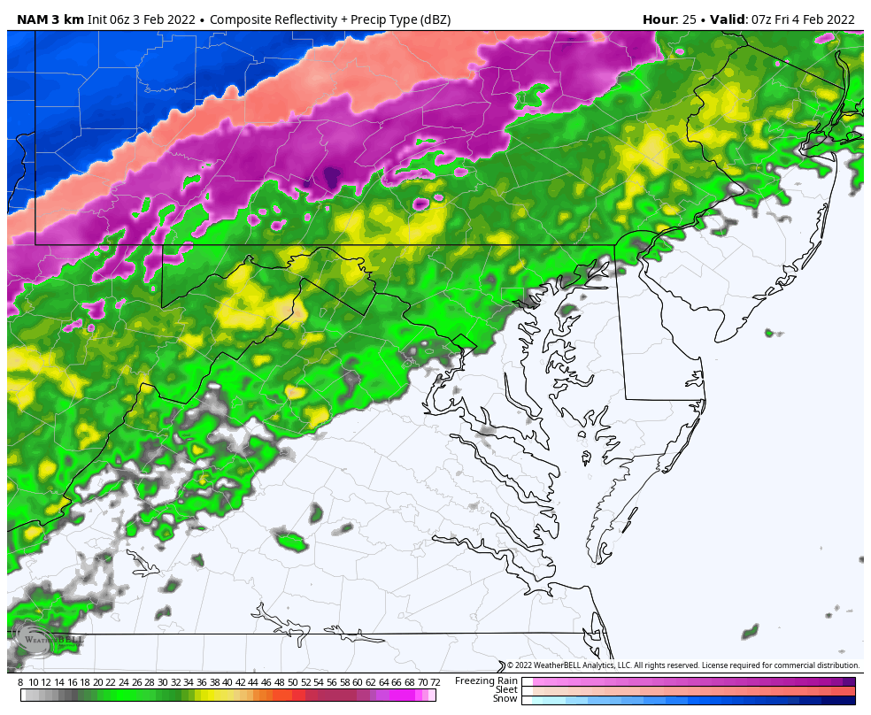
NEW Radar Simulation: NAM 3 Km
2 AM Friday to 6 PM Friday
Temperature Timeline —> slider
I’ve highlighted the local number forecast through the morning.
Recall, temps need to reach 32ºF or colder by 6 AM to have time for the ground to ice up before daylight battles to warm the ground.
I am aware there are some spelling and grammar typos. I have made a few public statements over the years, but if you are new here you may have missed it:
I have dyslexia, and found out at my second year at Cornell. I didn’t stop me from getting my meteorology degree, and being first to get the AMS CBM in the Baltimore/Washington region.
I do miss my mistakes in my own proofreading. The autocorrect spell check on my computer sometimes does an injustice to make it worse.
All of the maps and information are accurate. The ‘wordy’ stuff can get sticky.
There is no editor that can check my work when I need it and have it ready to send out in a newsworthy timeline.
I accept this and perhaps proves what you read is really from me…