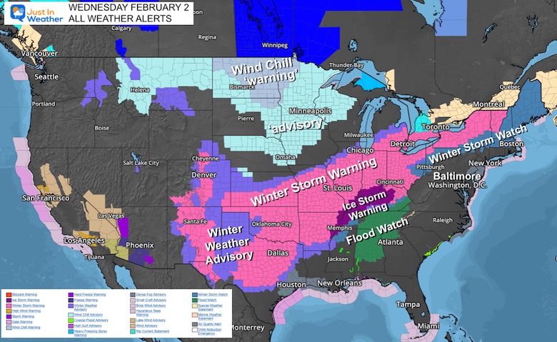
This is quite a storm crossing the central US today. In fact looking at all of the weather alerts, check out this spread: Winter Storm Warnings reach as far southwest as the West Texas border with Mexico, and as far northeast as the Vermont border with Canada!
To the north are widespread Wind Chill Warnings and Advisories. On the edge is a narrow Ice Storm, that is likely to expand as it pushes east. Will some of our region get in on it too?
There is high confidence that warming temps will bring us rain Thursday, then colder air will follow with an ice event. The questionable part of this is who will be affected by the icing Friday morning.
Places that do not get the icing in the morning, are still in play to ice up Friday evening as the sun goes down and this system departs allowing colder air to follow.
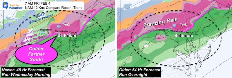
For starters, we have the NAM 12 Km and 3 Km BOTH trending faster and colder.This may sound accelerating, but it falls in line with the GFS and European Models. Basically metro Baltimore is still on the bubble, with inland areas west and north more likely to get icy around daybreak.
Model Comparisons at 7 AM Friday
NAM 12 Km
This model (newer on the left) brings the icing to the Baltimore Beltway. That is a drop south by about 20 to 30 miles from the prior run.
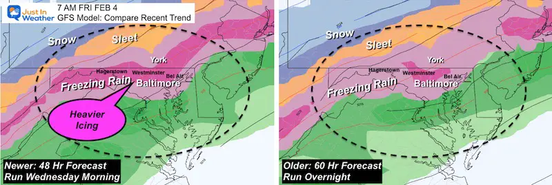
GFS Model
This has been most consistent about this ice event. The change here (newer on the left) is that darker pink shows heavier icing for the suburbs just north of Baltimore.
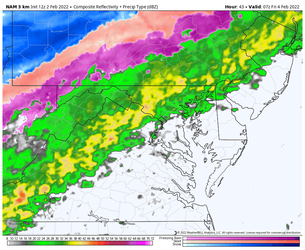
The largest adjustment has been the higher resolution NAM 3 Km Model. I will show that below along with slider timeline of temperatures.
Timing Is Key!
When an ice event starts with freezing rain or sleet, it is much different than a warm rain turning colder.In this case, we will have temps in the 40s and 50s with rain warming the ground, then turning colder.
That will take time to chill and allow pavement to catch up and ice over.
For any impact on the roads, I would suggest this:
The Freezing Line must arrive by around 6 AM. This allows about 2 hours until the sun angle is high enough in the sky (through the clouds) to help warm the pavement.
Places that drop below freezing that early, are more likely to have icing on the roads and impact travel for work and school.
Places that drop below 32ºF later, there may still be freezing rain, but more impact on car windows, signs, trees, and power lines.However the road would be more likely to stay wet.
In Depth Closer Look
I want to focus on the NAM 3 Km Model now for a few reasons.
This had the biggest adjustment trend colder
This high resolution model operates best within 48 hours of an event
This is one of the warmers solutions I have seen. Given that models tend to overplay arrival of cold air, I will put more attention on the slower arrival to plot the most likely places to ice over Friday morning.
Animation
2 AM Friday to 12 PM Friday
*Note, this model is one of the slowest to bring in the icing. But this is similar to the verified timing with our event two weeks ago.
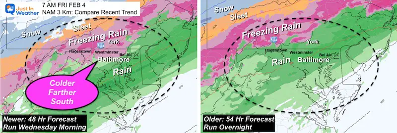
NAM 3 Km Model
Comparison
The abrupt change (even though still slower) is speeding up the cold air and icing.
Older model on the right was last night. It had rain at 7 AM still in York, PA.
Newer model plot of the left brings the icing (pink) through Westminster and close to the north side of the Baltimore Beltway and Bel Air. That is a jump south of the icing of more than 50 miles.
Temperature Timeline —> slider
I’ve highlighted the local number forecast through the morning.
Recall, temps need to reach 32ºF or colder by 6 AM to have time for the ground to ice up before daylight battles to warm the ground.
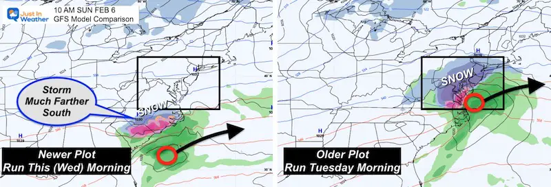
I gave a lot more respect to this model just one day ago, trying to keep up with a few wins last month. But it was alone with this storm.
In the 24 Hours that have followed, our chance for snow has been lost.
The snow is snow suppressed farther south, closer to what the European Model showed.
GFS Still Should Get Some Respect
While the second storm appears to be a non issue, the GFS model still was leading the way with the icing for us on Friday. It is still the colder of the models, which may suggest it needs additional calibration. However. I will give it the nod to catching this first.
Now we can just focus on this one event.In the next few reports I will do my best to highlight the areas that are most likely to get icing, and those that still are on the bubble worth watching.
Still plenty of winter ahead of us. I think we can all agree, snow is better than ice, so let’s root that on next time.
I am aware there are some spelling and grammar typos. I have made a few public statements over the years, but if you are new here you may have missed it:
I have dyslexia, and found out at my second year at Cornell. I didn’t stop me from getting my meteorology degree, and being first to get the AMS CBM in the Baltimore/Washington region.
I do miss my mistakes in my own proofreading. The autocorrect spell check on my computer sometimes does an injustice to make it worse.
All of the maps and information are accurate. The ‘wordy’ stuff can get sticky.
There is no editor that can check my work when I need it and have it ready to send out in a newsworthy timeline.
I accept this and perhaps proves what you read is really from me…