


Average Last Frost or Freeze Dates And Map For Maryland
There is a good reason why many gardeners suggest NOT to plan tomatoes until after Mother’s Day. Early surges of warm air in spring can be deceiving. Just because the…
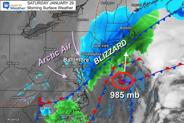
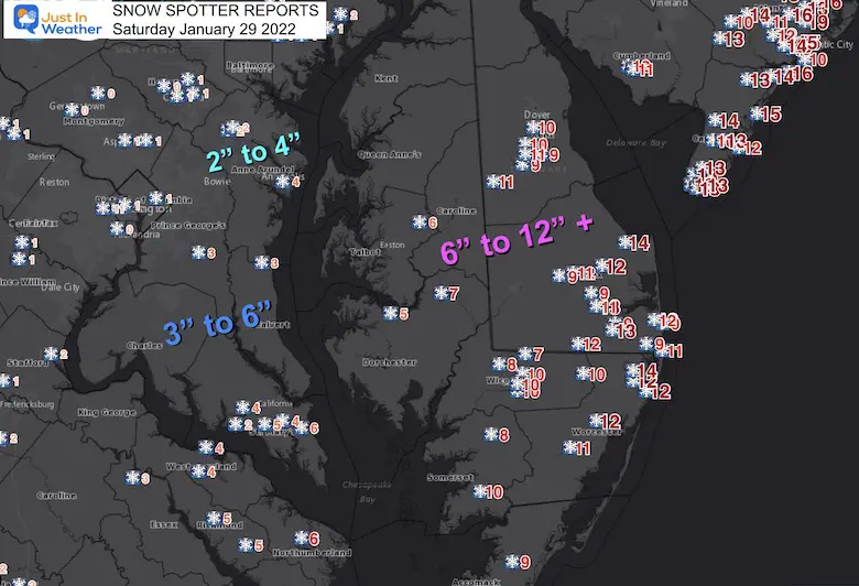
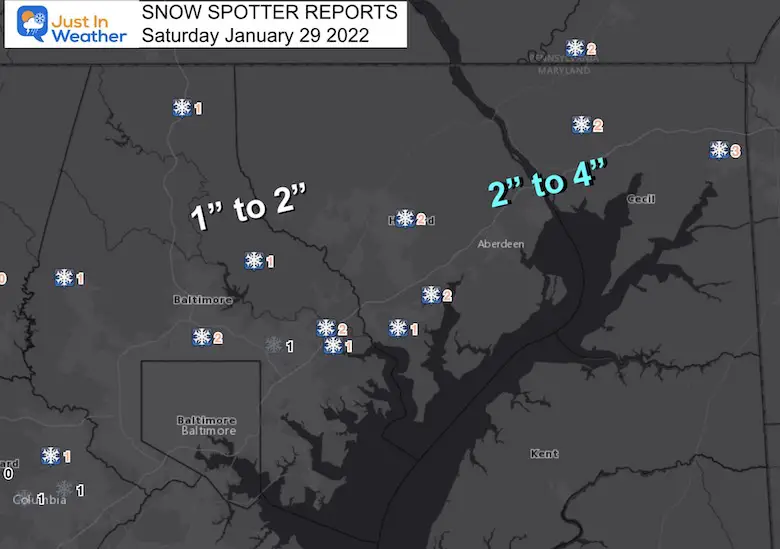
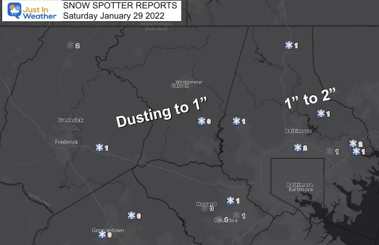
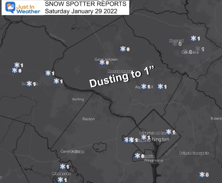
Saturday January 29 2022
There is nothing easy about any east coast storm for the Mid Atlantic. Throw in a true Blizzard and more snow expected for the beaches, it will leave many inland wanting more. It is nearly impossible to be perfect for everyone, but overall this storm worked out well. But I will highlight where I went wrong below.
BWI Official Snow Observation Confusion
However, they had a 2” snow depth, compared to a 0” snow depth yesterday.
Huh?
It turns out the snow measurement is to 0.1”, but snow depth is rounded to the Full Inch.
This weather map from Saturday morning tells the story of the sharp cutoff that was expected. There was a true split across the Chesapeake
Bay, but some of the western shore got in on the action. Please see the ‘Previous’ button at the top of this page if you would like to review all the reports and weather maps.
(Local maps and spotter lists are below the Grading Poll)
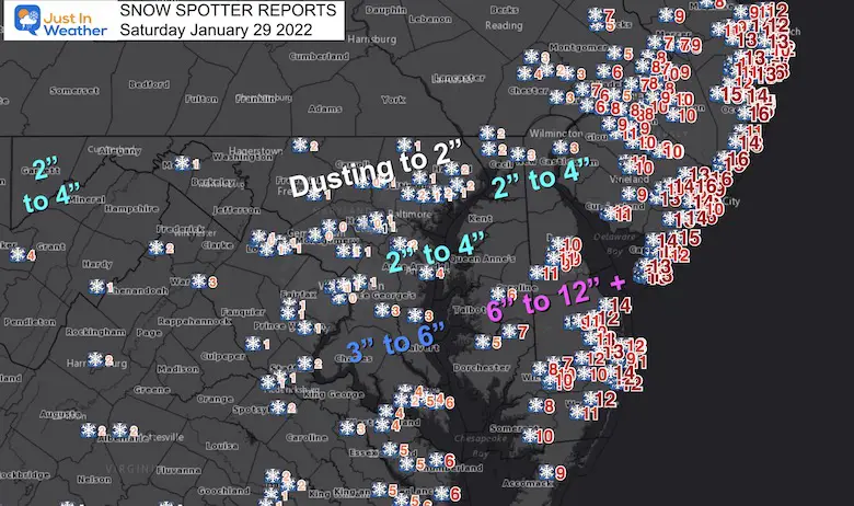
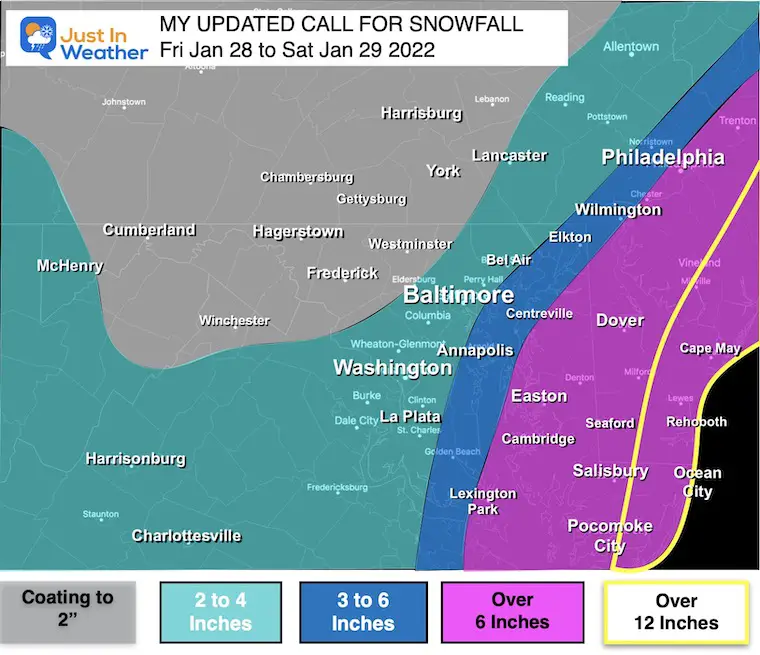
There was a lot more snow east, less west, and strong winds! My First Call For Snowfall may have worked out better for some than my Updated. I had to expand my snow expectation with the new data on Friday when Hurricane Hunters flight data showed the track closer to the coast. It was, but jut a little…
Very close to the actual results…
Improvement for higher totals east and south.
Too much added in parts of central Maryland.
(Also See: Top Snow Photos)
What Went Wrong?
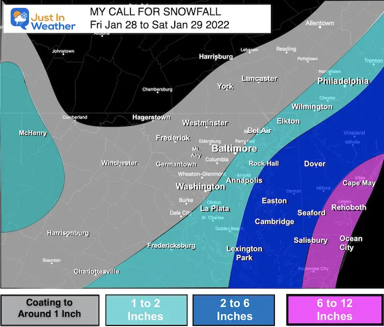
I started to track this storm last Monday, but downplayed the social hype. Even comparing the models, I was leaning towards the lower end of snow for central MD. It was when NOAA Hurricane Hunters flew in and get data showing the closer track to the coast, when I updated my snow map…
MY BIGGEST MISTAKE
I increased my 1” to 3” range up to 2” to 4” AND expanded it west of Baltimore and across metro Washington. I should have kept the first range.
The back edge of the snow was the hardest thing to predict. Any wobble of 20 to 30 miles would affect nearly 1 million people with more or less snow.
Lots of maps and spotter lists.
Please, first take part of my Poll To Grade My Forecast, or scroll the maps and list, then come back. I expect a wide range depending on your location in this event.
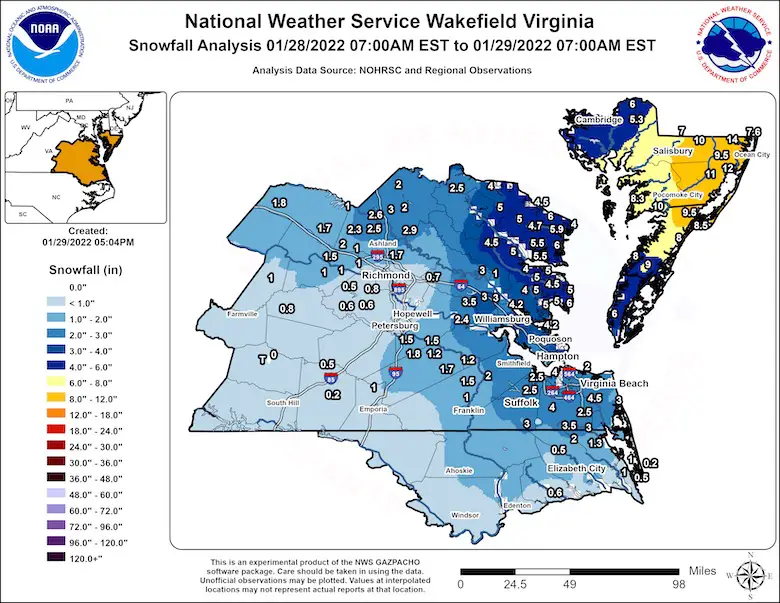
Big Winner! Delmarva and Southern Maryland
Annapolis did get 4″ of snow, with higher amounts to the south and east across the Bay spanning all of Delmarva.
From NWS AKQ
…Maryland…
…Dorchester County…
1 W Hurlock 6.0 in 0732 AM 01/29
2 ENE East New Market 5.5 in 0808 AM 01/29
Hurlock 1.9 SW 5.5 in 0800 AM 01/29
East New Market 1.9 SE 5.3 in 0400 AM 01/29
Cambridge 5.0 in 0921 AM 01/29
…Somerset County…
2 NNW Marion Station 10.0 in 0954 AM 01/29
Marion Station 1.7 S 8.3 in 0700 AM 01/29
…Wicomico County…
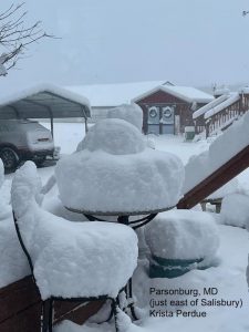
Parsonsburg 10.0 in 0700 AM 01/29
1 SSW Salisbury 10.0 in 1054 AM 01/29
Parsonsburg 1.6 WNW 9.5 in 0738 AM 01/29
1 NNE Salisbury 9.5 in 0920 AM 01/29
Delmar 7.0 in 0917 AM 01/29
…Worcester County…
1 NW Ocean Pines 14.0 in 0838 AM 01/29
Ocean Pines 0.9 SSW 12.5 in 0700 AM 01/29
Newark 12.0 in 1118 AM 01/29
1 S West Ocean City 12.0 in 0837 AM 01/29
Snow Hill 11.0 in 0836 AM 01/29
Berlin 9.5 in 0809 AM 01/29
Bishopville 3.1 E 7.6 in 0500 AM 01/29
…Maryland…
…Kent County…
Rock Hall 4.0 in 1200 PM 01/29 Trained Spotter
…Kent County…
5 SSE Sandtown 11.2 in 1230 PM 01/29 Public
Felton 9.0 in 0430 PM 01/29 Public
Dover 8.4 in 0200 PM 01/29 Mesonet
Woodside 8.1 in 0200 PM 01/29 Mesonet
Harrington 8.0 in 0200 PM 01/29 Mesonet
Smyrna 7.5 in 0220 PM 01/29 Trained Spotter
Frederica 7.1 in 0200 PM 01/29 Mesonet
West Dover 5.9 in 0200 PM 01/29 Mesonet
Smyrna 5.4 in 0200 PM 01/29 Mesonet
…New Castle County…
Bear 6.0 in 1141 AM 01/29 Trained Spotter
Odessa 5.2 in 1234 PM 01/29 Trained Spotter
2 SW Glendale 5.0 in 0240 PM 01/29 Trained Spotter
Hockessin 4.3 in 0115 PM 01/29 Trained Spotter
Blackbird 4.2 in 0200 PM 01/29 Mesonet
Talleyville 4.0 in 1215 PM 01/29 Public
Claymont 3.7 in 0200 PM 01/29 Mesonet
Port Penn 3.5 in 0200 PM 01/29 Mesonet
New Castle County Airport 3.4 in 0100 PM 01/29 ASOS
Talley 3.3 in 0200 PM 01/29 Mesonet
Glasgow 3.0 in 0200 PM 01/29 Mesonet
Newark 2.8 in 0200 PM 01/29 Mesonet
White Clay Creek 2.8 in 0200 PM 01/29 Mesonet
Greenville 2.7 in 0200 PM 01/29 Mesonet
New Castle 2.7 in 0200 PM 01/29 Mesonet
Newark 2.6 in 0148 PM 01/29 Trained Spotter
Prices Corner 2.5 in 0200 PM 01/29 Mesonet
Hockessin 2.2 in 0200 PM 01/29 Mesonet
…Sussex County…
3 W Lewes 14.2 in 0115 PM 01/29 Broadcast Media
2 WNW Bethany Beach 11.5 in 0400 PM 01/29 Public
Fenwick Island 11.4 in 0213 PM 01/29 Storm Chaser
Millsboro 11.1 in 0140 PM 01/29 Trained Spotter
Stockley 9.3 in 0200 PM 01/29 Mesonet
Dagsboro 9.1 in 0200 PM 01/29 Mesonet
Bethany Beach 9.0 in 0200 PM 01/29 Mesonet
3 WSW Georgetown 9.0 in 0129 PM 01/29 Trained Spotter
Ellendale 8.9 in 0200 PM 01/29 Mesonet
Lewes Nassau 7.5 in 0200 PM 01/29 Mesonet
Lewes University 6.5 in 0200 PM 01/29 Mesonet
Seaford 6.5 in 0200 PM 01/29 Mesonet
Bridgeville 5.9 in 0200 PM 01/29 Mesonet
Laurel 5.3 in 0200 PM 01/29 Mesonet
LOCATION TOTAL TIME/DATE COMMENTS
SNOWFALL MEASURED
(inches)
DISTRICT OF COLUMBIA
…District of Columbia…
National Zoo 1.1 1148 PM 1/28 Trained Spotter
National Arboretum 1.0 830 AM 1/29 Co-Op Observer
Washington 3 NE 0.9 700 AM 1/29 CoCoRaHS
National Zoo 1 WSW 0.5 320 AM 1/29 Trained Spotter
Dalecarlia Reservoir 0.1 800 AM 1/29 Co-Op Observer
MARYLAND
…Allegany County…
Frostburg 0.8 700 AM 1/29 Co-Op Observer
Cresaptown-Bel Air 1 0.3 700 AM 1/29 CoCoRaHS
Cumberland 0.2 700 AM 1/29 Co-Op Observer
…Anne Arundel County…
Birdsville WSW 3.8 515 AM 1/29 CoCoRaHS
Annapolis 1 SE 3.6 1001 AM 1/29 CoCoRaHS
Pasadena 3 ESE 3.5 800 AM 1/29 CoCoRaHS
Churchton ENE 3.5 700 AM 1/29 Trained Spotter
Riva 2 WNW 3.0 730 AM 1/29 Trained Spotter
Deale 1 SE 3.0 700 AM 1/29 CoCoRaHS
Crownsville 3 SSW 2.9 800 AM 1/29 Trained Spotter
Birdsville 2.8 1200 AM 1/29 NWS Employee
Crofton 1 SSE 2.4 740 AM 1/29 NWS Employee
Odenton 1 WNW 2.3 728 AM 1/29 Trained Spotter
Severn 2 SSW 2.0 831 AM 1/29 CoCoRaHS
Green Haven 1 ESE 2.0 810 AM 1/29 Trained Spotter
Crofton 2 NNE 2.0 800 AM 1/29 NWS Employee
Odenton 1 N 1.9 700 AM 1/29 CoCoRaHS
Chelsea Beach 1.6 100 AM 1/29 Trained Spotter
Bwi Airport 1.5 700 AM 1/29 Airport
Glen Burnie 1 WSW 1.4 445 AM 1/29 Trained Spotter
…Baltimore County…
Edgemere ESE 2.2 740 AM 1/29 Trained Spotter
Gunpowder 2 W 1.7 900 AM 1/29 Trained Spotter
Towson 1 SW 1.7 830 AM 1/29 CoCoRaHS
Upper Falls 2 SW 1.7 855 AM 1/29 Trained Spotter
White Marsh 2 ESE 1.4 700 AM 1/29 CoCoRaHS
White Marsh 2 E 1.3 900 AM 1/29 Trained Spotter
Bentley Springs 1 E 1.3 900 AM 1/29 Trained Spotter
Long Green 1 SW 1.3 700 AM 1/29 CoCoRaHS
Perry Hall 1 NNE 1.2 747 AM 1/29 Trained Spotter
Timonium NE 1.1 700 AM 1/29 CoCoRaHS
Pikesville 2 SW 1.0 600 AM 1/29 CoCoRaHS
Long Green 2 NW 1.0 940 AM 1/29 Trained Spotter
…Baltimore City…
Pimlico SE 1.0 610 AM 1/29 Trained Spotter
Hamilton NE 0.9 600 AM 1/29 CoCoRaHS
Mount Washington 1 N 0.8 800 AM 1/29 CoCoRaHS
…Calvert County…
Prince Frederick 1 S 5.0 600 AM 1/29 Trained Spotter
Dunkirk 3.2NNE 4.0 800 AM 1/29 CoCoRaHS
Tracys Landing 2 WSW 4.0 800 AM 1/29 Trained Spotter
Huntingtown SW 3.6 735 AM 1/29 Trained Spotter
Prince Frederick 1 W 3.6 800 AM 1/29 CoCoRaHS
Chesapeake Beach 4 S 3.0 800 AM 1/29 CoCoRaHS
Lusby ESE 3.0 205 AM 1/29 Trained Spotter
Dowell 2 NE 2.5 730 AM 1/29 Trained Spotter
…Carroll County…
Mount Airy SE 0.7 800 AM 1/29 CoCoRaHS
Eldersburg 1 SE 0.5 700 AM 1/29 Trained Spotter
Westminster 3 SSW 0.5 700 AM 1/29 CoCoRaHS
Taneytown 4 NE 0.5 800 AM 1/29 CoCoRaHS
Eldersburg 1 E 0.5 700 AM 1/29 CoCoRaHS
Gamber 1 WNW 0.4 816 AM 1/29 NWS Employee
Gamber 1 W 0.4 800 AM 1/29 CoCoRaHS
…Cecil County…
Elkton 2 W 2.8 530 AM 1/29 Dept of Highways
Elkton 5 NW 2.7 700 AM 1/29 CoCoRaHS
Elkton 1 NNW 2.5 900 AM 1/29 CoCoRaHS
Woodlawn 2 ENE 2.1 844 AM 1/29 Trained Spotter
…Charles County…
Bryantown 2 NE 3.2 715 AM 1/29 CoCoRaHS
Dentsville 1 SW 2.8 1130 PM 1/28 Trained Spotter
La Plata 6 SE 2.8 700 AM 1/29 CoCoRaHS
Waldorf 3 S 2.8 800 AM 1/29 CoCoRaHS
Waldorf 2 W 2.1 520 AM 1/29 Trained Spotter
Nanjemoy 5 S 1.7 700 AM 1/29 CoCoRaHS
…Frederick County…
Thurmont 3 N 1.9 700 AM 1/29 CoCoRaHS
Emmitsburg 2 SE 1.0 645 AM 1/29 Co-Op Observer
Adamstown 1 ESE 0.8 700 AM 1/29 NWS Employee
New Market 2 NW 0.5 930 AM 1/29 CoCoRaHS
…Garrett County…
Grantsville 5 W 3.0 800 AM 1/29 Dept of Highways
Frostburg 3 WNW 3.0 706 AM 1/29 Trained Spotter
Mc Henry 4 SW 2.0 600 AM 1/29 Co-Op Observer
…Harford County…
Abingdon 1 SE 1.5 900 AM 1/29 Trained Spotter
Bel Air 2 W 1.1 800 AM 1/29 Trained Spotter
Forest Hill 1 NNW 1.0 800 AM 1/29 Trained Spotter
Forest Hill 3 SW 1.0 755 AM 1/29 Trained Spotter
Magnolia 1.0 925 AM 1/29 Trained Spotter
Chrome Hill 2 SE 0.5 1216 AM 1/29 Trained Spotter
…Howard County…
Laurel 1 NNE 1.6 800 AM 1/29 CoCoRaHS
Savage 1 WSW 1.2 730 AM 1/29 Trained Spotter
Elkridge 1.2 742 AM 1/29 NWS Employee
North Laurel 2 ESE 1.2 730 AM 1/29 CoCoRaHS
Elkridge 2 W 1.2 645 AM 1/29 Trained Spotter
Columbia 2 N 0.8 700 AM 1/29 CoCoRaHS
Columbia 0.8 800 AM 1/29 NWS Employee
Marriottsville 3 S 0.8 700 AM 1/29 CoCoRaHS
Columbia 2 NE 0.6 900 AM 1/29 Trained Spotter
Sykesville 2 SSE 0.6 700 AM 1/29 CoCoRaHS
Ellicott City 0.5 1245 AM 1/29 Broadcast Media
Clarksville 2 N 0.4 1100 AM 1/29 Trained Spotter
…Montgomery County…
Colesville 2 W 1.1 700 AM 1/29 CoCoRaHS
Colesville 1.0 832 AM 1/29 Trained Spotter
Rossmoor 1 ESE 0.9 700 AM 1/29 CoCoRaHS
Silver Spring 6 NNE 0.9 430 AM 1/29 CoCoRaHS
Rockville 3 E 0.8 700 AM 1/29 CoCoRaHS
Norbeck 1 ESE 0.8 700 AM 1/29 CoCoRaHS
Aspen Hill 1 SW 0.7 915 AM 1/29 Trained Spotter
Bethesda 2 WNW 0.7 700 AM 1/29 CoCoRaHS
White Oak 1 N 0.7 700 AM 1/29 CoCoRaHS
Potomac 1 NNW 0.6 700 AM 1/29 CoCoRaHS
Damascus 3 SSW 0.6 700 AM 1/29 Co-Op Observer
Olney 1 ENE 0.6 630 AM 1/29 CoCoRaHS
Gaithersburg 3 NE 0.5 700 AM 1/29 CoCoRaHS
Poolesville SE 0.5 800 AM 1/29 CoCoRaHS
Montgomery Village 1 0.5 630 AM 1/29 CoCoRaHS
Damascus 1 S 0.5 703 AM 1/29 Trained Spotter
Takoma Park 1 NNW 0.5 700 AM 1/29 CoCoRaHS
Clarksburg 1 SSE 0.4 1200 AM 1/29 CoCoRaHS
Germantown 5 NNE 0.4 600 AM 1/29 CoCoRaHS
North Potomac 4 N 0.4 700 AM 1/29 CoCoRaHS
Laytonsville 2 WNW 0.3 900 AM 1/29 Trained Spotter
Potomac 3 NE 0.3 700 AM 1/29 CoCoRaHS
...Prince Georges County…
Brandywine 7 ESE 3.6 700 AM 1/29 CoCoRaHS
Marlton 1 WSW 3.0 900 AM 1/29 Trained Spotter
Bowie 4 S 2.5 700 AM 1/29 CoCoRaHS
Suitland 2 SE 1.5 700 AM 1/29 CoCoRaHS
Fort Washington 1 SS 1.0 700 AM 1/29 CoCoRaHS
…St. Marys County…
Ridge 1 N 5.5 700 AM 1/29 CoCoRaHS
Park Hall 1 NNE 5.5 930 AM 1/29 Trained Spotter
Ridge 1 ENE 5.5 700 AM 1/29 Trained Spotter
Callaway 2 W 5.1 833 AM 1/29 Trained Spotter
Leonardtown 1 NE 5.0 600 AM 1/29 CoCoRaHS
California 2 W 4.7 715 AM 1/29 Trained Spotter
Great Mills 4 S 4.1 700 AM 1/29 CoCoRaHS
Leonardtown SSE 4.0 904 AM 1/29 Trained Spotter
Hollywood 3 S 4.0 745 AM 1/29 Trained Spotter
Great Mills 1 NNE 4.0 906 AM 1/29 Trained Spotter
Mechanicsville 7 SE 3.7 700 AM 1/29 CoCoRaHS
California 3 W 3.5 800 AM 1/29 Trained Spotter
Compton 2 ESE 2.4 630 AM 1/29 Trained Spotter
Compton 3 SSE 2.0 830 AM 1/29 Trained Spotter
…Washington County…
Keedysville 2 SSE 1.0 700 AM 1/29 CoCoRaHS
Sharpsburg 5 S 1.0 700 AM 1/29 Co-Op Observer
Hancock 1 ESE 0.8 700 AM 1/29 CoCoRaHS
Boonsboro 3 NNE 0.8 1100 PM 1/28 Trained Spotter
Hagerstown 1 ENE 0.4 700 AM 1/29 CoCoRaHS
Hagerstown 4 NNW 0.4 700 AM 1/29 CoCoRaHS
Williamsport 3 ENE 0.3 600 AM 1/29 CoCoRaHS

Faith in the Flakes!


Last Winter Recap: My Old Outlook And Your Grades Of My Storm Forecasts


*Disclaimer due to frequent questions:
I am aware there are some spelling and grammar typos. I have made a few public statements over the years, but if you are new here you may have missed it:
I have dyslexia, and found out at my second year at Cornell. I didn’t stop me from getting my meteorology degree, and being first to get the AMS CBM in the Baltimore/Washington region.
I do miss my mistakes in my own proofreading. The autocorrect spell check on my computer sometimes does an injustice to make it worse.
All of the maps and information are accurate. The ‘wordy’ stuff can get sticky.
There is no editor that can check my work when I need it and have it ready to send out in a newsworthy timeline.
I accept this and perhaps proves what you read is really from me…
It’s part of my charm.
#FITF