Conditions: Baltimore, Maryland, 05/19/2024 08:40:03 pm
Temperature

71°

Mostly Sunny

60°

Dew Point
Relative Humidity

68%

Feels Like

71°

Wind (NW)

3mph

Air Pressure

29.96

Sun
Sun Rise

05:49 AM

Sun Set

08:17 PM

Day Length

14:28 Hours

Difference

1 min 38 sec gain

Moon
Moon Rise

04:40 PM

Moon Set

03:43 AM

Next: Full Moon

May 23,2024

Moon Phase

Waxing Gibbous

Climate
Average Low

53°

75°

Average High
Record Low

38°


(2009)

98°


(1962)
Record High
Conditions

Snowfall Timeline And Compare Totals From Models

Maryland Weather
Winter Weather
Forecast
Warnings

Thursday Mid Day Update 

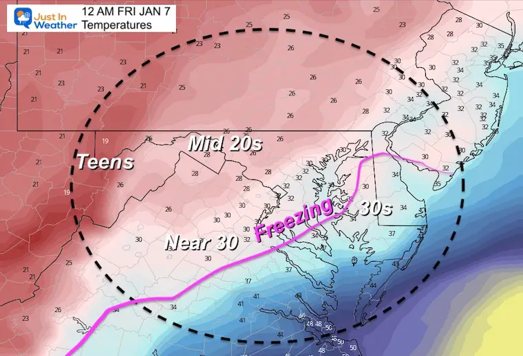
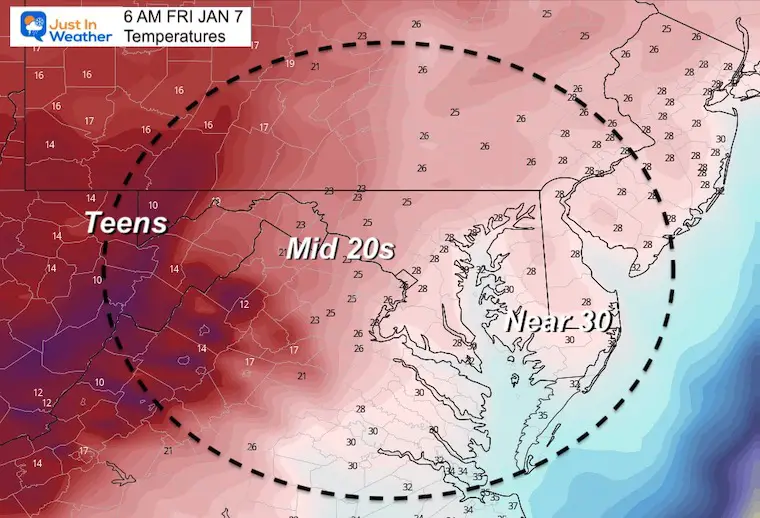
The storm is taking form now. There is a lot of moisture well north of the Low Pressure center. With the overnight timing AND cold temperatures, there is potential for this to overachieve.

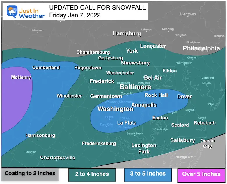
I know we are in the game of maps with snow totals, and it is easy to want to gravitate to the highest numbers.   I stand by my initial call on two things:

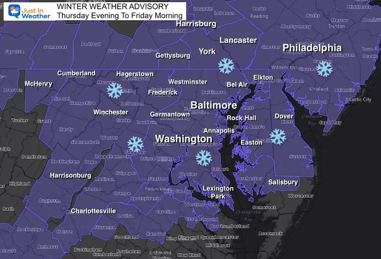
Timing will be overnight tonight and ending before sunrise. 

This will be a general 2 to 4 inch snow event.  

My first map was conservative, then increased a little this morning.  I will have a final call map later today to include the highest end I see possible. You can compare the range of potential on this NWS Snow Map page.

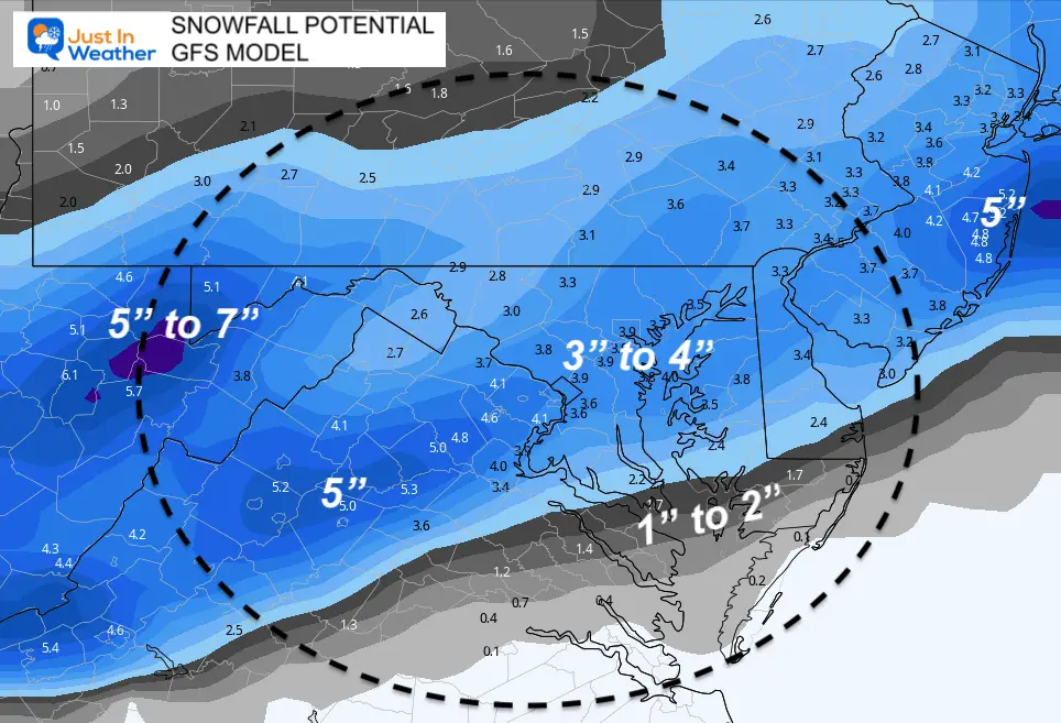
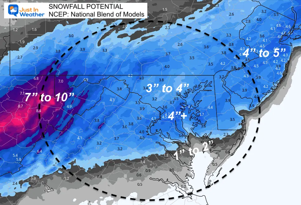
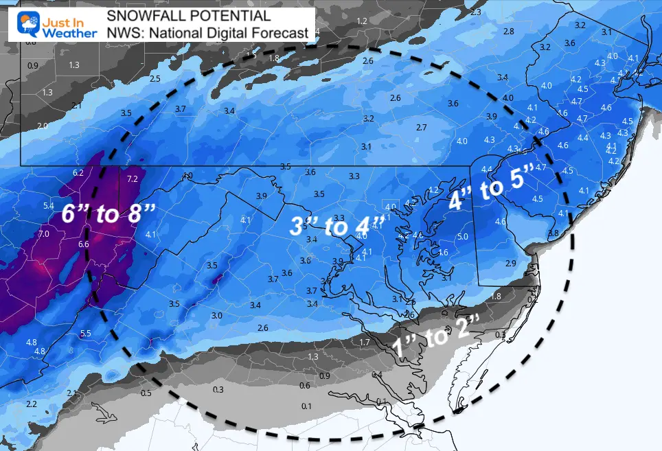
In this report I included a few model snow maps for you to compare.  

Set Up: Thursday Mid Day


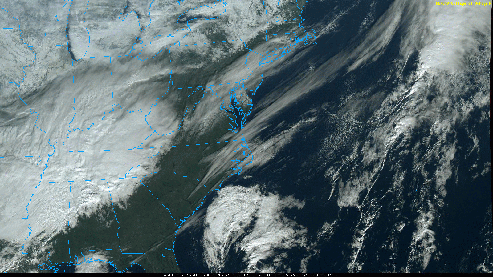
Satellite Loop (Visible)


January-6-weather-storm-satellite-thursday


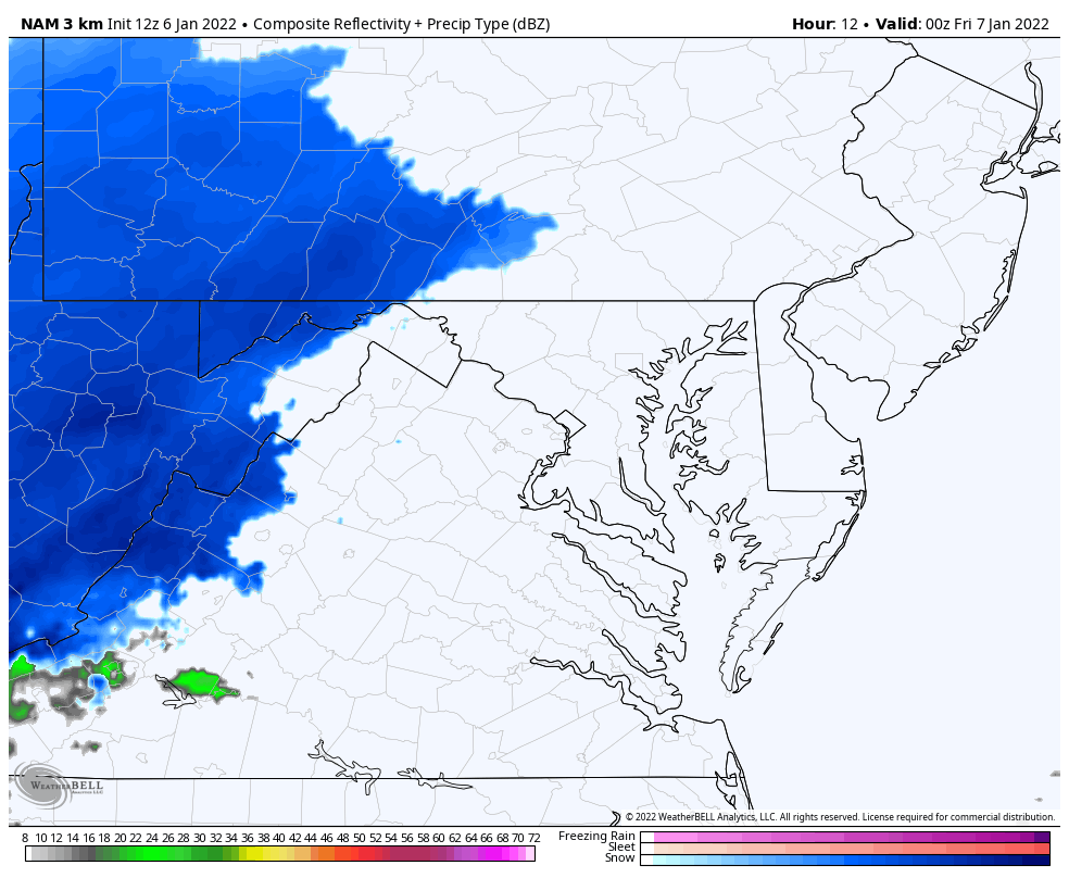
Radar Simulation —> slider

HRRR Model

  • This is the highest resolution and most frequently updates product.
  • Snow will begin late afternoon in the mountains. This will track along NW hills/ridges for a few hours into the evening.
  • Metro areas will get it by midnight, then ending before sunrise. 
  • Southern Maryland may begin with rain, then end with snow.


january-6-weather-snow-radar-simulation-hrrr-thursday-pm-5
january-6-weather-snow-radar-simulation-hrrr-thursday-pm-6
january-6-weather-snow-radar-simulation-hrrr-thursday-pm-7
january-6-weather-snow-radar-simulation-hrrr-thursday-pm-8
january-6-weather-snow-radar-simulation-hrrr-thursday-pm-9
january-6-weather-snow-radar-simulation-hrrr-thursday-pm-10
january-6-weather-snow-radar-simulation-hrrr-thursday-pm-11
january-6-weather-snow-radar-simulation-hrrr-friday-am-12
january-6-weather-snow-radar-simulation-hrrr-friday-am-1
january-6-weather-snow-radar-simulation-hrrr-friday-am-2
january-6-weather-snow-radar-simulation-hrrr-friday-am-3
january-6-weather-snow-radar-simulation-hrrr-friday-am-4
january-6-weather-snow-radar-simulation-hrrr-friday-am-5
previous arrow
next arrow


NAM 3 Km Model

This has shifted north, pushing the snow north. I am not sure I can completely buy the results here.

January-6-weather-snow-nam-pm


Expectations:

  • Evening Snow moves in from mountains to NW hills.
  • Metro Areas get snow just before midnight.
  • Heaviest snow after midnight.
  • Total snow for most about 6 hours…
  • Ending for most by sunrise Friday.
  • Generally 2 to 4 inches. Some spots may be higher.
  • Temperatures will be colder, so this snow will be more ‘fluffy’ with easy stickage.


Temperatures

Midnight: Cooling to the upper 20s when the snow begins.


Morning: Remaining in the mid to upper 20s


Snowfall Products: Model Compared 

There is some agreement, but still areas with a wide spread to contrast.


GFS Model


NCEP: National Blend of Models


NWS: National Digital Forecast


Winter Weather Advisory

Most of our region will experience impact snow tonight. 


My Call For Snowfall 

If there is a need to adjust this any further, I will post a final map later today.


Weather posts straight to your inbox

Sign up and be the first to know!


ALSO SEE


What is Faith in the Flakes: History of December 5th Snow


ALL FITF GEAR


FITF THUNDERSNOW


Winter Outlook Series:

My Call For Snowfall


Last Winter Recap: My Old Outlook And Your Grades Of My Storm Forecasts

Winter Weather Page – Lots of resources


Solar Cycle Increasing Sunspots Suggests More Snow


Comparing 4 Different Farmer’s Almanacs: Majority colder winter outlook than NOAA


NOAA Winter Outlook- But Read The Fine Print


Signals For Early Start To Winter In November


Winter Outlook Series: La Nina Double Dip


Nor’easters May Give Hint For Winter La Nina Pattern


Winter Folklore Checklist


Please share your thoughts, best weather pics/video, or just keep in touch via social media

Facebook: Justin Berk, Meteorologist

Twitter: @JustinWeather

Instagram: justinweather