Issued Sunday January 2- Early Afternoon
We are less than 24 hours of this snow event and it is been a race to catch up. I had light snow in our Monday forecast for a few days, but the evolution of the pattern has been abrupt. This does fit my suggestion in my Winter Outlook that we would get a storm when models are late to catch it, and it would seem like a surprise.
Well, I hope at least the two day lead time here has made the only surprise the abrupt change form 60s to snow.
Impact Consideration:
This will be on the Monday after a holiday and during the Covid Surge. I do not know what your local school or business has planned… But perhaps more flexibility to let this run its course and stay in a few extra hours/full day.
I do not know how flights will be affected. I have been surprised in the past with staying on time when I expected delays, or delays when I though it wasn’t too bad.
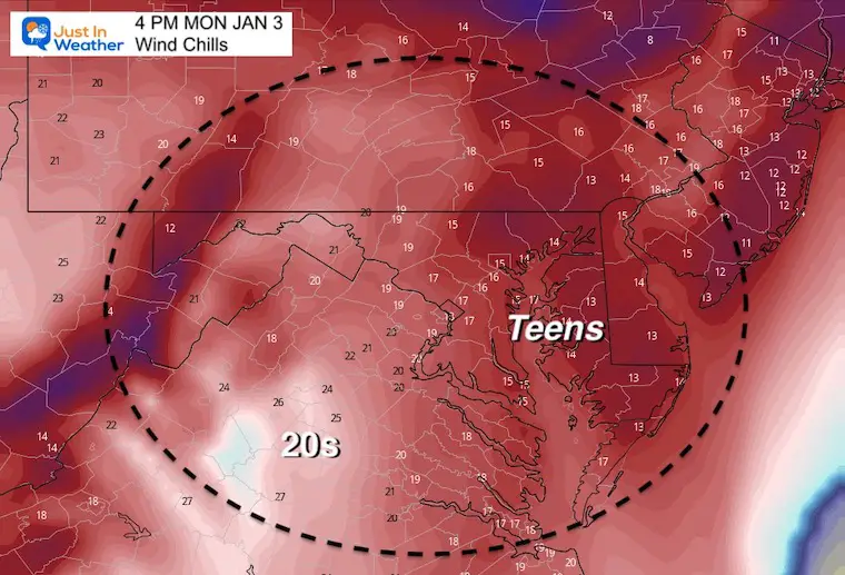
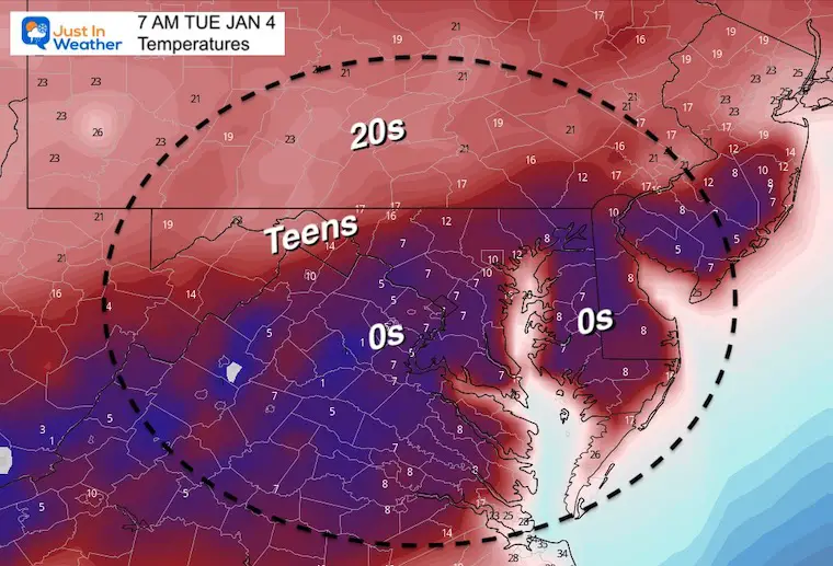
Below is my First Call Map, explanation, and the other important factor: Temperatures. It will turn very cold… So consider wind chills Monday, then single digit temps Tuesday morning.
I am following my own protocol to bring a First Call For Snowfall Map- showing the Low End Confident Range. The + is for the upside potential.
There is a MUCH HIGHER range on the modeling, but no matter how good it looks, I have trouble biting at that nugget yet. I will save any of that for my Final Call tonight.
Compare My Call to Models and NWS Maps. I like to share my thoughts, but I am human. It’s best to get a few perspectives and then you can adjust your expectations accordingly.
My First Call For Snowfall
I am going much lower than model forecast maps I’ve shown… Leaving upside potential at this time.
I had to play this conservative, however: Snowfall rates will exceed 1”/hour in the sweet spot zone. The dynamics support even higher snowfall rates, which can blow totals about of proportion.
My final call tonight will include my take on the full range of potential snowfall. That map may change a lot based on finalizing the timing and track.
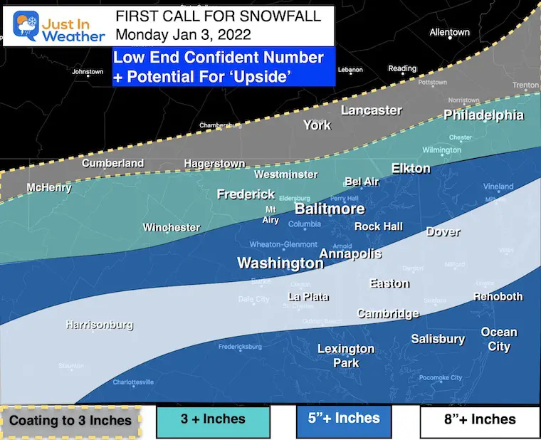
Zones:
Coating to 3”+
Cumberland- Hagerstown-York-Lancaster
This is the northern edge of the snow. Any shift of 20 miles could double or eliminate snow impact. Most of this will fall between 4 AM to 10 AM
3” +
McHenry to Frederick – Westmister – Elkton- Phildelphia
The northern edge of the steady snow. This also under the suspicion: Any shift of 20 miles could double or eliminate snow impact. Most of this will fall between 4 AM to 12 PM
5”+
There is potential for a large upside here…
Snowfall rates will reach or exceed 1″/Hr.
- Germantown-Mt. Airy- Columbia- Baltimore- Bel Air
- Heaviest will be during the morning commute. Ending early afternoon.
And
- Southern Maryland to Salisbury to Ocean City:
- May begin with rain then mix over. Heaviest snow will be mid day and afternoon. Temps will drop and support stickage.
8”+ Range
There is potential for a large upside here…
- There will be a Sweet Spot Stripe of the heaviest snow.
- Snowfall rates will exceed 1″/hour… That can blow snowfall totals out of proportion.
- This is likely to be across parts of central VA, Southern Maryland, and central Delmarva.
- This is where the faster change over to all snow will take place, while remaining close enough to the coastal storm for high impact.
- Heavy snow will be morning to mid afternoon.
Timing:
This will begin After Midnight
May start as rain in southern areas then turn to snow during the morning.
The concern is the falling temps, helping wet pavement turn icy under snowpack and when exposed after plowing.
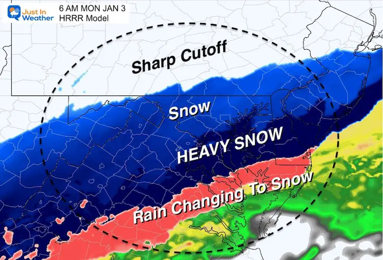
Click here to see the HRRR Model I showed in my last report. I will have an updated situation later today.
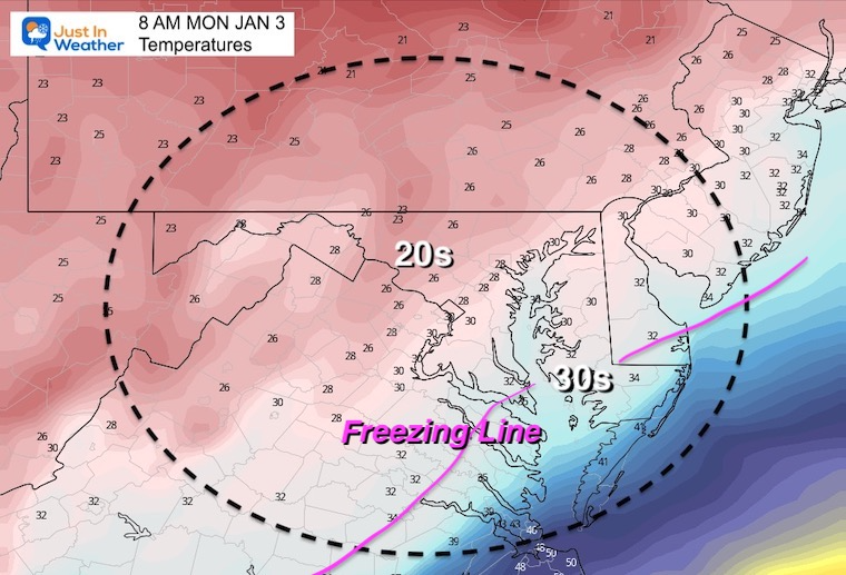
Temperature Forecast:
Based off of the GFS Model
Monday Morning
The Freezing Line will pushing across Southern Maryland to Lower Eastern Shore.
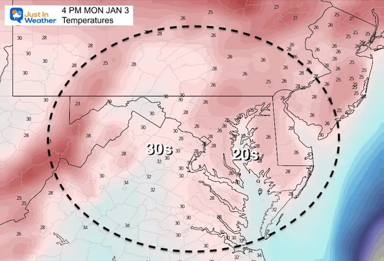
Monday Afternoon
Trending to stay in the 20s
Wind Chill
It will be blustery with this storm that will generate the snow, thanks to pulling in arctic air.
Tuesday Morning
This seems a bit excessive, but the GFS is trying to allow for clearing and fresh snowpack to support the intrusion of arctic air in the single digits.
Click to see my Morning Repot Comparing 4 Model Snow Maps
Next Up:
Winter Weather Alert Updates. I expect more will be adjusted by evening.
NWS Snow and Ice Forecasts
Official – High End – Low End – Onset Time – and Ice When needed
Click the map for the full package of maps
Save This Link: It will auto update as new maps are generated
NOAA Winter Weather Maps
Click the map for the full package of maps
Save This Link: It will auto update as new maps are generated
ALSO SEE
Winter Outlook Series:
My Call For Snowfall

Last Winter Recap: My Old Outlook And Your Grades Of My Storm Forecasts


Please share your thoughts, best weather pics/video, or just keep in touch via social media


