Friday October 29
The storm is not completely done. The bulk of the rain has moved through, but there will be some lingering showers overnight. More importantly, the focus remains on the high water in the Chesapeake Bay.
I wanted to share some flooding that has already occurred, and also the forecast through Saturday. This includes select locations for high water and High/Low Tides.
While the storm did underperform with wind gusts, it has lived up to flooding potential already. The high tide overnight is expected to produce the highest water levels, but the forecasts below are lowered a little from earlier.
Flooding View
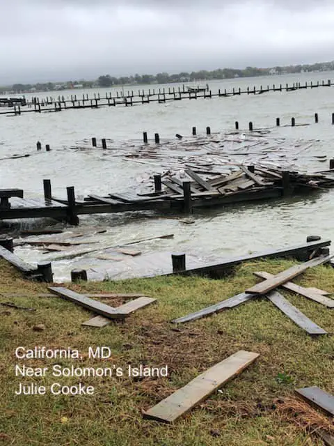
The high water on Friday was substantial. In Southern Maryland it destroyed these docks in California, by Solomons Island.
Storm View: Friday Evening
The wind and water flow has prevented waster from draining out of the Bay. The winds are lighter now, but will still keep water levels up through Saturday.
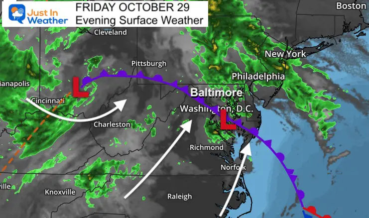
The Wind Advisory has been dropped, and it seems the gusts remained below potential for most of the region. The fast winds remained aloft, but did not completely reach the surface.
However, the wind flow has shifted to the South. That keeps the pressure on the Chesapeake Bay. The storm already did not allow the low tide to drain out, and we have at least one more complete tide cycle that will push higher water into already flooded areas.
Flood Advisories and Warnings
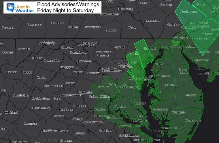
Central Maryland Flooding
Here is a collection of flood video and photos from the afternoon.
High Water Forecast: 11 PM Friday
Click to image to see the full animation
High Water Forecasts
Select Locations Shown here:
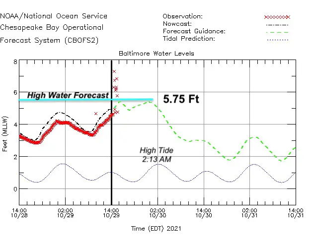
Baltimore: Water Levels Expected to reach 5.75 Ft above normal.
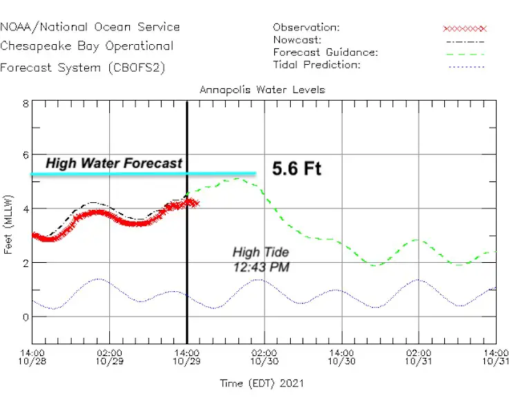
Annapolis: Water Levels Expected to reach 5.6 Ft above normal.
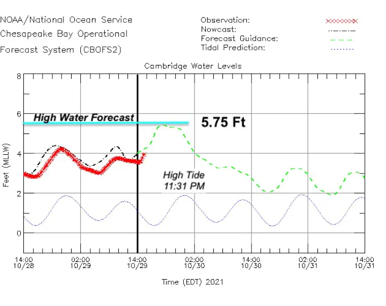
Cambridge: Water Levels Expected to reach 5.75 Ft above normal.
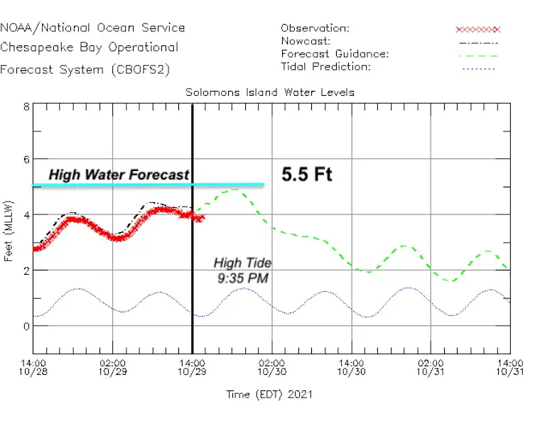
Solomons: Water Levels Expected to reach 5.75 Ft above normal.
Flooding in Southern Maryland
Oct 29, 2021 flooding and big wave action on Chesapeake Bay in southeastern St. Mary’s County, Md./ Tanner Creek. @TonyPannWBAL @NWS_BaltWash @ReedTimmerAccu @dcsplicer @DCstorms @MChasercon @JimCantore @iCyclone @JustinWeather @MetzStormMedia pic.twitter.com/kYA7wBo36n
— Tim Grooms (@tim_grooms) October 29, 2021
You can search for many other spot forecasts here:
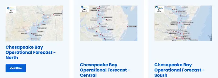
Operational Bay Forecasts
Click to see water forecast levels, winds, and tides for dozens of locations
High Tide and Low Tide Tables
West Side Chesapeake Bay
Havre de Grace
Saturday
- High 5:26 AM
- Low 1:03 PM
- High 5:59 PM
Bowley Bar, Middle River
Saturday
- High 3:04 AM
- Low 10:19 AM
- High 3:37 PM
- Low 9:27 PM
Baltimore, Fort McHenry
Saturday
- High 2:13 AM
- Low 9:36 AM
- High 2:46 PM
- Low 8:44 PM
Annapolis, US Naval Academy
Saturday
- High 12:43 AM
- Low 7:52 AM
- High 1:16 PM
- Low 7:00 PM
Chesapeake Beach
Friday
High 11:26 PM
Saturday
- Low 6:31 AM
- High 11:59 AM
- Low 5:39 PM
Solomons Island, Patuxent River
Friday
- High 9:35 PM
Saturday
- Low 4:50 AM
- High 10:08 AM
- Low 3:58 PM
- High 10:29 PM
East Side Chesapeake Bay
Charlestown, Northeast River
Saturday
- High 6:05 AM
- Low 1:39 PM
- High 6:38 PM
Metapeake, Kent Island
Saturday
- High 12:43 AM
- Low 7:47 AM
- High 1:16 PM
- Low 6:55 PM
Choptank River – Cambridge
Friday
- High 11:31 PM
Saturday
- Low 7:08 AM
- High 12:04 PM
- Low 6:16 PM
Wicomico Rivier, Salisbury
Friday
- High 10:35 PM
Saturday
- Low 5:11 AM
- High 11:14 AM
- Low 5:20 PM
- High 11:35 PM
Atlantic Coast
Ocean City Fishing Pier
Saturday
- High 3:14 AM
- Low 9:14 AM
- High 3:42 PM
- Low 10:06 PM
Search For More Tide Charts
Weather posts straight to your inbox
Sign up and be the first to know!
Also See The Winter Outlook Series:
NOAA Winter Outlook- But Read The Fine Print
Signals For Early Start To Winter In November
Winter Outlook Series: La Nina Double Dip
Nor’easters May Give Hint For Winter La Nina Pattern
Faith in the Flakes Gear
SNOWSTIX – Available Now
Please share your thoughts, best weather pics/video, or just keep in touch via social media
Facebook: Justin Berk, Meteorologist
Twitter: @JustinWeather
Instagram: justinweather


