Conditions: Baltimore, Maryland, 04/25/2024 04:20:03 am
Temperature

53°

Mostly Cloudy

44°

Dew Point
Relative Humidity

71%

Feels Like

53°

Wind (NNE)

7mph

Air Pressure

30.17

Sun
Sun Rise

06:14 AM

Sun Set

07:54 PM

Day Length

13:40 Hours

Difference

2 min 18 sec gain

Moon
Moon Rise

10:02 PM

Moon Set

06:52 AM

Next: Last Quarter

May 01,2024

Moon Phase

Waning Gibbous

Climate
Average Low

46°

68°

Average High
Record Low

30°


(1956)

94°


(1960)
Record High
Conditions

October 29 Storm Day: High Winds And Major Coastal Flooding

Flooding
Severe Weather
Forecast
Warnings

Friday  October 29

Today is our storm day! Rain has already moved in, and a lull has been expected, before the main event mid day through evening. 

This report has a look at the Advisories for wind and coastal flooding, radar simulation and new wind forecasts below.

Schools have closed in anticipation of a combination of these factors. It will be worst this afternoon!

Traffic Problems: 

  • Storm drains clogged with leaves and wet leaves on road.
  • Wind restrictions on bridges likely.
  • Trees and power lines may get knocked down.
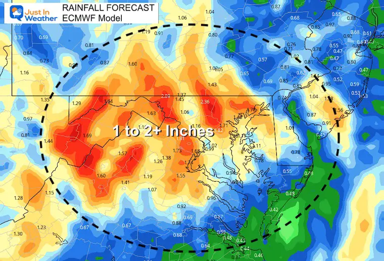
  • There will also be a total of 1 to 2+ inches of rainfall, which could lead to local inland flooding. 
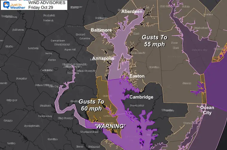
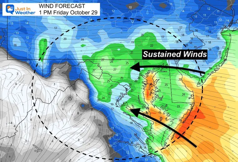
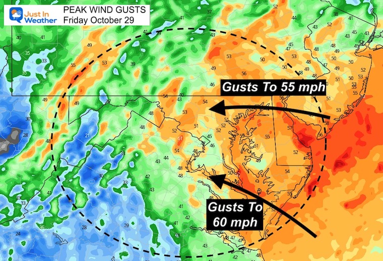
  • Winds will also be gusting mid day and this afternoon between 50 and 60 mph.


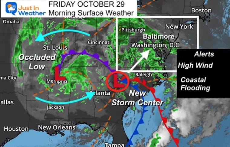
Morning Surface Weather

The original storm has occluded. This new Low is what we will get today. That large circulate is responsible for the strong winds from the East-Southeast.

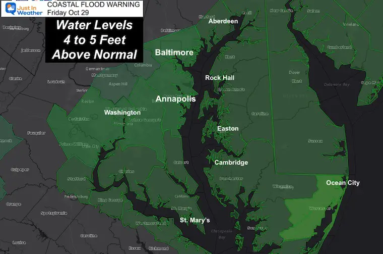
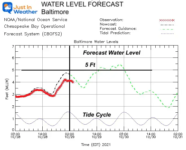
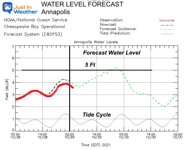
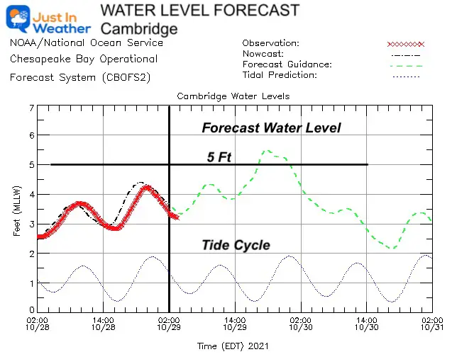
Major flooding is expected along the coastal areas of the Chesapeake Bay and some rivers. I have a spotlight on water level forecasts below for Baltimore, Annapolis, and Cambridge.


Worst Flooding in 10 to 20 years:

I have seen that it was NWS that made the mention of Hurricane Isabel. That storm raised a lot of anxiety. This is not the same as that once Cat 5 hurricane, but the flooding may be comparable ‘in some areas’, but not all. 


UPDATE AT 10:30 AM

 Click to see the NEW TIMELINE SIMULATION


Radar Simulation —> slider

Severe Storm Outlook

The risk for storms to turn severe is marginal, but the wind speeds may mimic severe storm limits (58 mph).


october-29-weather-storm-radar-rain-AM-8
october-29-weather-storm-radar-rain-AM-10
october-29-weather-storm-radar-rain-PM-12
october-29-weather-storm-radar-rain-PM-1
october-29-weather-storm-radar-rain-PM-2
october-29-weather-storm-radar-rain-PM-3
october-29-weather-storm-radar-rain-PM-4
october-29-weather-storm-radar-rain-PM-5
october-29-weather-storm-radar-rain-PM-6
october-29-weather-storm-radar-rain-PM-7
october-29-weather-storm-radar-rain-PM-8
october-29-weather-storm-radar-rain-PM-9
october-29-weather-storm-radar-rain-PM-10
october-29-weather-storm-radar-rain-PM-11
previous arrow
next arrow

Coastal Flood Advisory


Water Level Spotlights

Next few High Tides may bring water more than 5 Feet ABOVE NORMAL


Baltimore


Annapolis 


Cambridge

 Also high water on the Lower Eastern Shore.


Wind Warnings


Additional Resources

Boating and Bay page you will see

Water Forecast Animations

This includes currents, water levels, wind, water temps, and salinity. Click this image to control the maps.


chesapeak-bay-water-forecast-maps


Click here for: Maryland Tide Tables


Wind Forecast 

Animation 8 AM to 10 PM

October-29-weather-wind-forecast-friday-morning


Sustained Winds- Mid Day


Peak Wind Gusts – Full Storm


Rain Forecast


Weather Almanac: Climate Data

TODAY October 29

Normal Low in Baltimore:  42ºF

Record 26ºF in 2001


Normal High in Baltimore: 63ºF

Record 82º F 1946


What to wear Today?

Rain Jacket: Chilly with heavy rain and strong winds at times. 


Temperatures


7 Day Forecast

Lingering effects from the storm over the weekend. 

Next week, turning MUCH COOLER!


Weather posts straight to your inbox

Sign up and be the first to know!


Also See The Winter Outlook Series:

Winter Folklore Checklist


NOAA Winter Outlook- But Read The Fine Print


Signals For Early Start To Winter In November


Winter Outlook Series: La Nina Double Dip


Nor’easters May Give Hint For Winter La Nina Pattern


Faith in the Flakes Gear


SNOWSTIX – Available Now


Please share your thoughts, best weather pics/video, or just keep in touch via social media

Facebook: Justin Berk, Meteorologist

Twitter: @JustinWeather

Instagram: justinweather