Conditions: Baltimore, Maryland, 03/29/2024 05:00:04 am
Temperature

40°

Clear

24°

Dew Point
Relative Humidity

53%

Feels Like

35°

Wind (W)

7mph

Air Pressure

29.92

Sun
Sun Rise

06:54 AM

Sun Set

07:27 PM

Day Length

12:33 Hours

Difference

2 min 34 sec gain

Moon
Moon Rise

07:00 PM

Moon Set

08:49 AM

Next: Last Quarter

Apr 01,2024

Moon Phase

Waning Gibbous

Climate
Average Low

37°

58°

Average High
Record Low

18°


(1923)

90°


(1945)
Record High
Conditions

Radar Tracking Storms Monday Afternoon

Severe Weather
Forecast

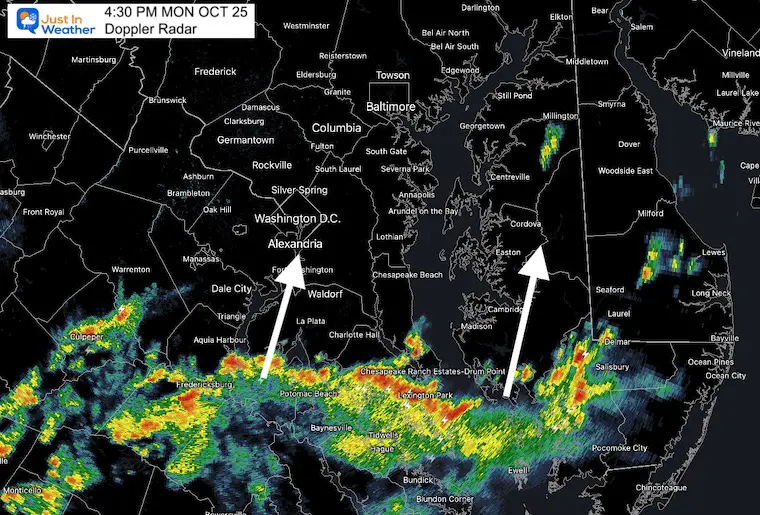
At 4:30 PM, Doppler Radar looked much more robust than even the simulation I showed earlier.

Watch this line of storms from the south get close to Annapolis and Rt. 50 around 6 PM.

This means southern Maryland, Washington, Kent Island, Cambridge and Easton get it before dark.

Then metro Baltimore will get in on this, and the line arriving from the west through midnight.

Note: Central Maryland has already reached a record High Temperature this afternoon at BWI. This is helping to fuel the intensity of the storms on the way…

See the Live radar and Lightning widget and Forecast Simulation is at the bottom of this quick post.


Radar Animation

2:30 PM to 4:30 PM

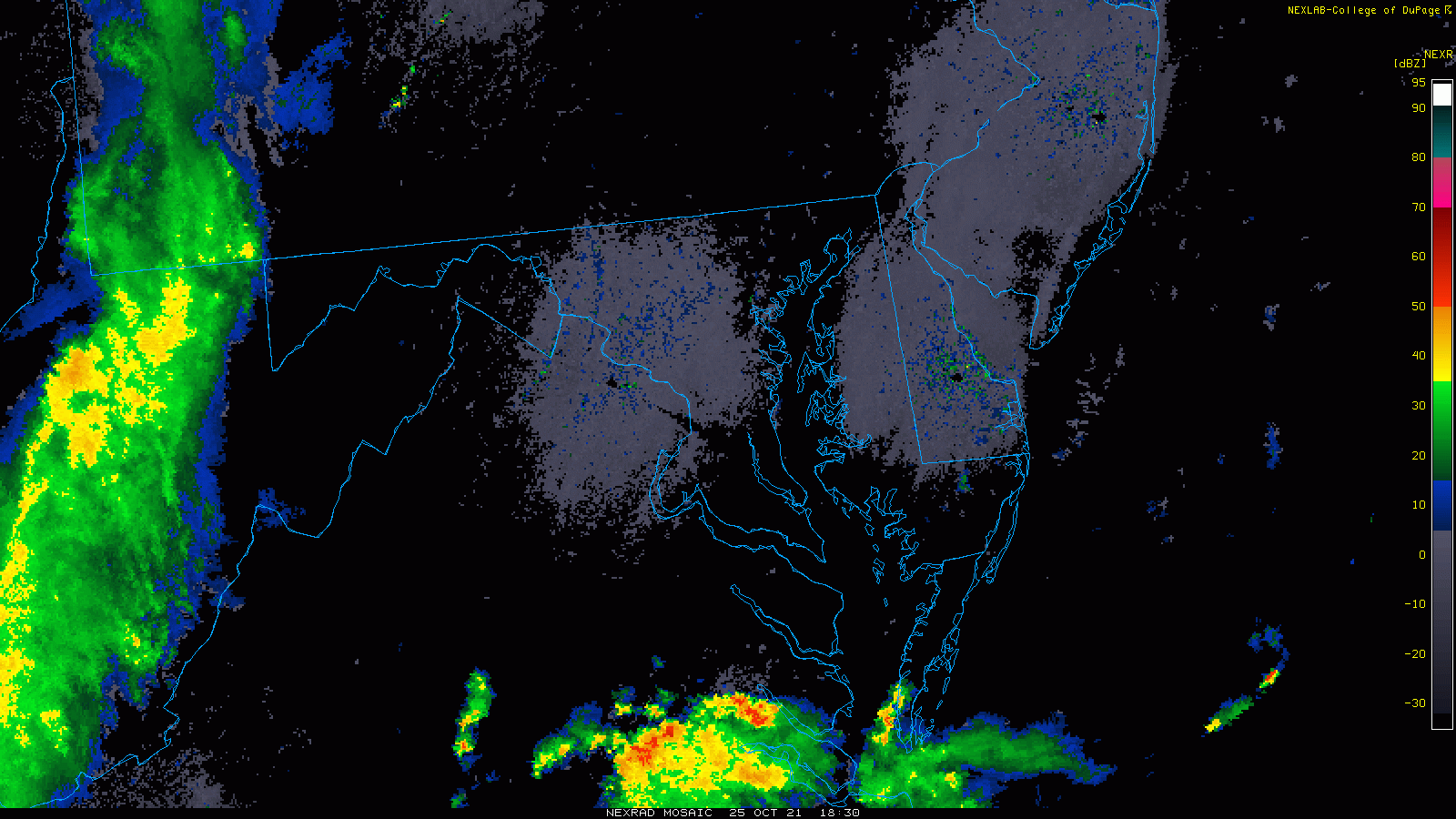
Here we can see a better view of the two lines about to clash over our region. 

The strong storm line moving north into southern Maryland

And

The line ahead of the cold front arriving from the west. 


October-25-weather-radar-storm-monday-afternoon


Reminder about alerts should any be issued.

  • Watch means it might happen.
  • Warning means it is happening and being tracked.
  • Regional Alerts can be found on the Home Page


Water Vapor Satellite Loop

2:30 PM to 4:30 PM

The large circulation with the upper Low swirling in Indiana is the driving force. 


October-25-weather-satellite-storm-monday-afternoon


Live Radar and Lightning Widget


Compare to…

Simulation Radar —-> slider

We will watch for scattered showers forming in the southern Bay to move north. That would enhance the eruption of storms this evening.

If that does not develop, then the activity will be less robust than shown here.

october-25-weather-storm-radar-monday-PM-4
october-25-weather-storm-radar-monday-PM-5
october-25-weather-storm-radar-monday-PM-6
october-25-weather-storm-radar-monday-PM-7
october-25-weather-storm-radar-monday-PM-8
october-25-weather-storm-radar-monday-PM-9
october-25-weather-storm-radar-monday-PM-10
october-25-weather-storm-radar-monday-PM-11
october-25-weather-storm-radar-tuesday-AM-12
october-25-weather-storm-radar-tuesday-AM-1
october-25-weather-storm-radar-tuesday-AM-2
previous arrow
next arrow


Email Updates

Please make sure you sign up for my newsletter.


Weather posts straight to your inbox

Sign up and be the first to know!


Also See:

NOAA Winter Outlook- But Read The Fine Print

Signals For Early Start To Winter In November

Winter Outlook Series: La Nina Double Dip

Nor’easters May Give Hint For Winter La Nina Pattern


Faith in the Flakes Gear


SNOWSTIX – Available Now


Please share your thoughts, best weather pics/video, or just keep in touch via social media

Facebook: Justin Berk, Meteorologist

Twitter: @JustinWeather

Instagram: justin