Saturday May Bring Severe Storms Then Last Winter Push Next Week
March 17 2022
Evening Report
Before I get into this, I want to make myself clear to you. I am self aware. I do have a small obsession with snow, but after my trip to Florida last weekend I am done with winter. So what I show you is not hope or hype for a storm. It is simply letting you know that while temps will warm again to the 70s, as soon as Friday, there may be a round of severe storms this weekend and one more attempt at winter later next week.
The Polar Vortex has once again entered the conversation, but it started with Dr. Judah Cohen. I’ll show you. That does not mean another snowstorm, but maybe hold off on changing your wardrobe over a little longer.
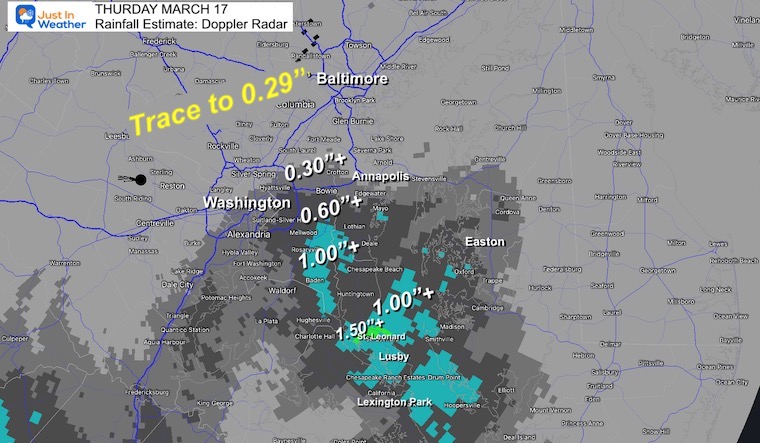
Thursday Rain Total
A quick summary of the rain today, which was heavy for some and underwhelming for many. The ‘soggy’ forecast applied to less than half of our region. Here is a look at the Doppler Radar Rainfall Estimate. More rain fell around Rt. 50 and southward.
Friday Morning FOG:
Just a note that there may be some thick morning fog. Especially if you had rain Thursday afternoon or evening.
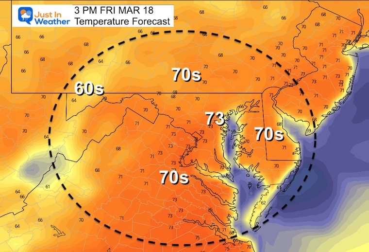
Friday High Temperatures
Back to the 70s. It will be a nice day and feel like spring, but don’t be fooled.
Saturday:
Things Get Interesting
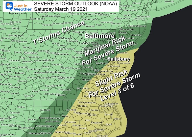
NOAA Outlook
For now the risk for severe storms is Marginal to Slight. That’s Level 2 and 3 out of 6.
The greatest risk is shown on the Lower Eastern Shore, but I think we may have to keep central Maryland in mind as well.
There will be showers in the morning, but we should watch the time frame between 4 PM and 8 PM.
5 PM Snapshots
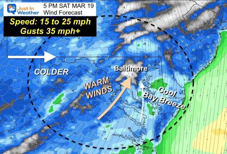
Wind Forecast
Wind will be noticeable and influential. The steady winds will 15 to 25 mph. But gusts will be 35 to 40 mph.
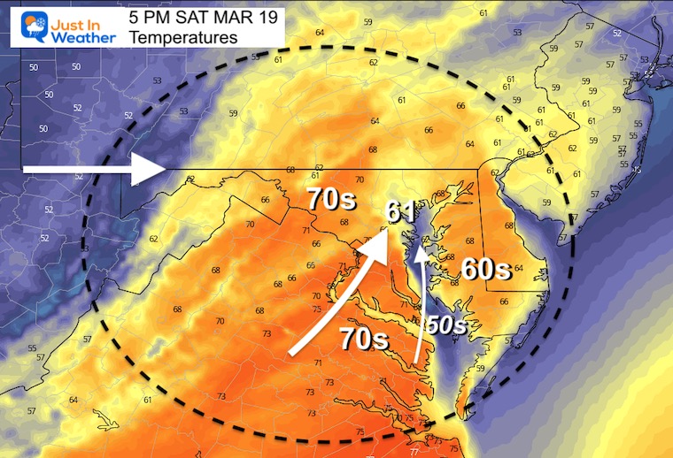
Saturday Afternoon Temperatures
While there will be inland 70s, the fetch across the Chesapeake Bay will enhance the cooling 60s.
To the west will be the next cold air mass. This will create a lot of turbulence in the atmosphere to maximize storm potential.
Severe Weather Parameters
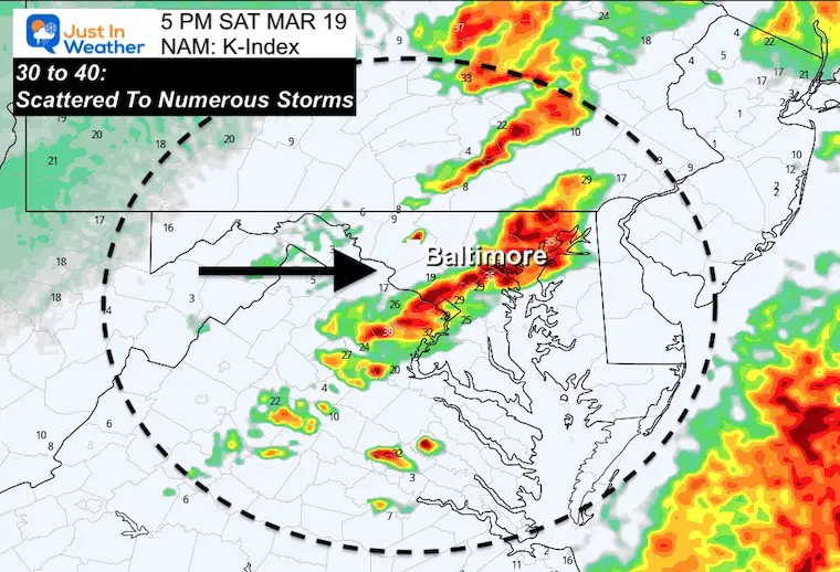
k-Index
This is a measure of storm potential. With the measurement OVER 30, there is an expectation for scattered to widespread storms.
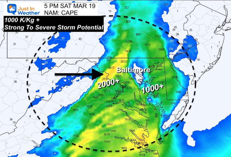
CAPE
This stands for Convective Available Potential Energy and is measure in Joules per kilogram (for the science geeks)
- Over 1000 J/Kg and we have a chance for strong storms to turn severe.
- Over 2000 J/Kg and the likelihood of Severe Storms increases.
The low level cold air support medium to large hail.
Radar Snapshot
This is a guide and not perfect. This product has underperformed with big events. So I will track this and look for the line and surrounding activity to fill in a bit more as we get closer.
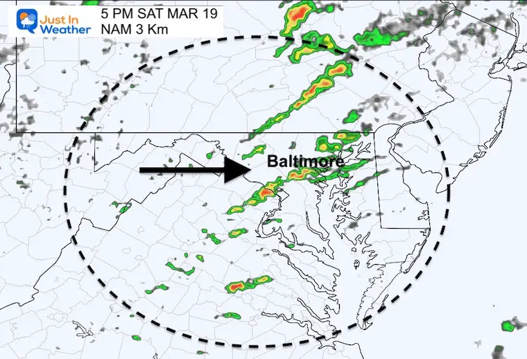
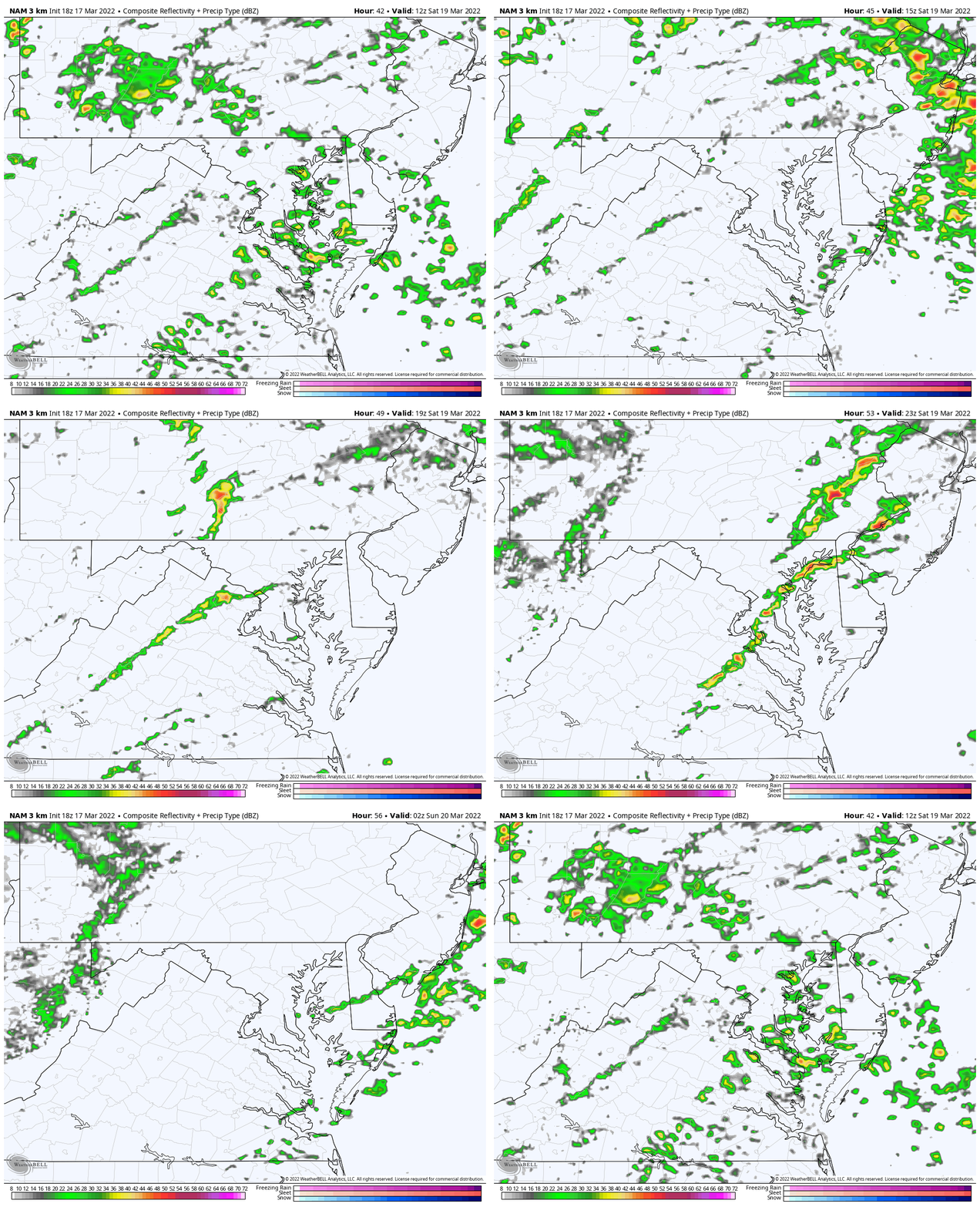
Radar Simulation
Saturday 6 AM to 10 PM
There will be morning showers then a break before the storm line. The day may depend on breaks of sun and how far the warm air surges in.
But Wait…. Winter is TRYING to still show up.
Before I show you the Jet Stream, let’s toss it to Dr. Judah Cohen… Who has been on a tear with polar Vortex talk this week.
“If it looks like a duck, swims like a duck and quacks like a duck, it is probably a duck.” Yesterday’s ECMWF forecast resembled a reflective event (aka stretched #polarvortex) & today’s GFS confirmed it with all the trimmings. Details in the blog: https://t.co/Gg8N2KHLUk pic.twitter.com/SXPOXsZaE2
— Judah Cohen (@judah47) March 16, 2022
Note: He is based in Boston, but he is showing snow for western Maryland and near the MD/PA line.
If you like me in the Northeast, looking to score one more hit of white powder in the backyard or to ski, the week of vernal equinox could be our best bet based on GFS & Canadian #snow forecasts, as Ol’ Man #Winter inevitably cedes to the more youthful & eternally hopeful Spring pic.twitter.com/eoHnFooHkE
— Judah Cohen (@judah47) March 17, 2022
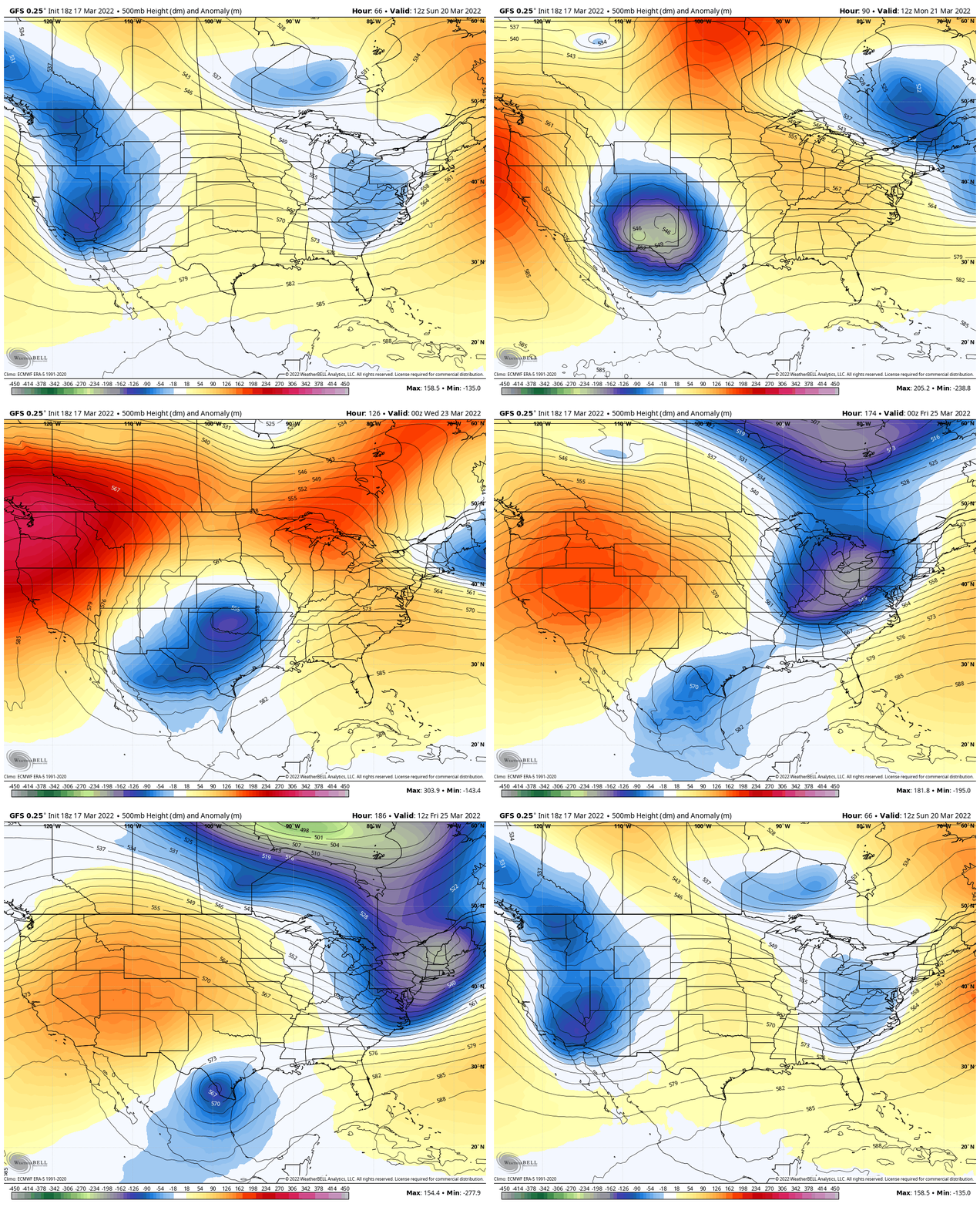
Jet Stream Animation:
Sunday March 20 to Friday March 25
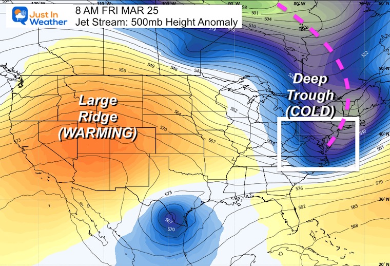
Snapshot: Friday March 25
We will get into colder air at the end of next week. That will come with a storm, but I am not trussing the surface plots of any models this early in the game… But keep your guard up. Also note that IF snow make a return to the discussion recall the trouble with stickage in metro areas last weekend.
I’ll see you Friday morning for the full forecast…
Weather posts straight to your inbox
Sign up and be the first to know!
ALSO SEE
What is Faith in the Flakes: History of December 5th Snow
ALL FITF GEAR
FITF THUNDERSNOW
Winter Outlook Series:
Last Winter Recap: My Old Outlook And Your Grades Of My Storm Forecasts
Winter Weather Page – Lots of resources
Solar Cycle Increasing Sunspots Suggests More Snow
Comparing 4 Different Farmer’s Almanacs: Majority colder winter outlook than NOAA
NOAA Winter Outlook- But Read The Fine Print
Signals For Early Start To Winter In November
Winter Outlook Series: La Nina Double Dip
Nor’easters May Give Hint For Winter La Nina Pattern
Winter Folklore Checklist
Please share your thoughts, best weather pics/video, or just keep in touch via social media
Facebook: Justin Berk, Meteorologist
Twitter: @JustinWeather
Instagram: justinweather
*Disclaimer due to frequent questions:
I am aware there are some spelling and grammar typos. I have made a few public statements over the years, but if you are new here you may have missed it:
I have dyslexia, and found out at my second year at Cornell. I didn’t stop me from getting my meteorology degree, and being first to get the AMS CBM in the Baltimore/Washington region.
I do miss my mistakes in my own proofreading. The autocorrect spell check on my computer sometimes does an injustice to make it worse.
All of the maps and information are accurate. The ‘wordy’ stuff can get sticky.
There is no editor that can check my work when I need it and have it ready to send out in a newsworthy timeline.
I accept this and perhaps proves what you read is really from me…
It’s part of my charm.
#FITF


