Snow has arrived earlier and already producing a coating to 2 inches in northern and western areas.This has led to the belief that higher totals will result, prompting a Winter Storm Warning in southern PA.
Heavy snow in the high western mountains has been desperately needed and they may overachieve at ski areas as well.
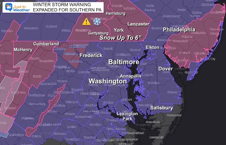
Winter Storm Warning: Expanded to Southern PA
Expanded to include Southern PA: Adams, York, Lancaster, and metro Harrisburg include.
In Maryland: Washington County has been added.
Snow up to 6 inches.
The simulations I shared all day showed the delay of snow arriving for the cities and central Maryland until later, but I understand it can seem like it might not happen. However, many schools have already been delayed, so I imagine the concern I have been hearing is just that people want to be able to watch it snow before they go to sleep.
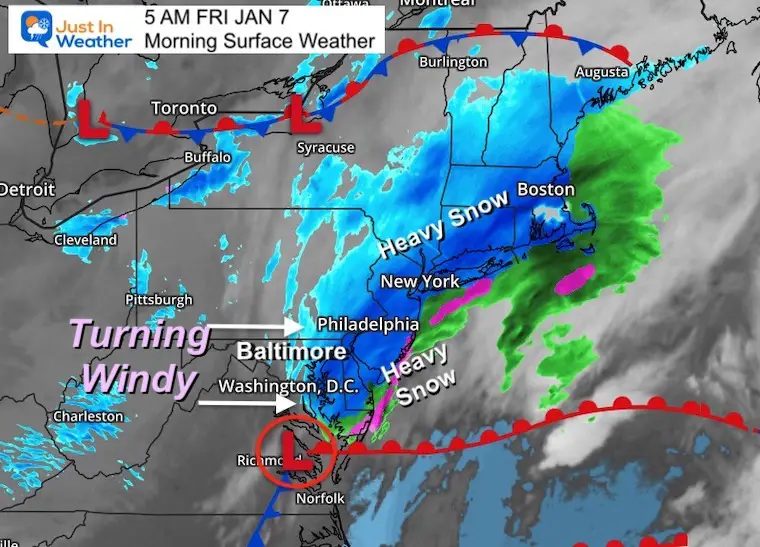
That dry bubble will collapse, and it looks like it may be happening sooner than the HRRR model suggested.
When the snow breaks through, it will come down at rates of 1 to 2 inches per hour a times. So the accumulation will happen in a hurry.
I’ve included a new timeline below.
10 PM Thursday:
Mesoscale Analysis
looks like the energy transfer to the developing coastal Low may be happening closer to the coast. This would result in a stronger burst of snow in that burst zone I highlighted.
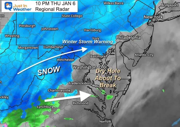
Radar Snapshot
Snow has persisted to the north all evening.
To the south, an intrusion of moisture- mixed with rain. That was expected for Southern Maryland.
More coverage here compared to the first forecast image below.
This first image is the ‘forecast’ for 10 PM from a two hours ago.
Initialization: Underplaying what has been observed above.
That is optimistic news if you are anxiously waiting the snow hole to break.
This model may be off by an hour or two with when that will happen. It should be snowing in metro areas ‘around midnight’, on target with the expectations all day. Faith in the Flakes
january-6-snow-radar-update-hrrr-thursday-pm-10
january-6-snow-radar-update-hrrr-friday-am-12
january-6-snow-radar-update-hrrr-thursday-pm-11
january-6-snow-radar-update-hrrr-friday-am-1
january-6-snow-radar-update-hrrr-friday-am-2
january-6-snow-radar-update-hrrr-friday-am-3
january-6-snow-radar-update-hrrr-friday-am-4
january-6-snow-radar-update-hrrr-friday-am-5
january-6-snow-radar-update-hrrr-friday-am-6
january-6-snow-radar-update-hrrr-friday-am-7
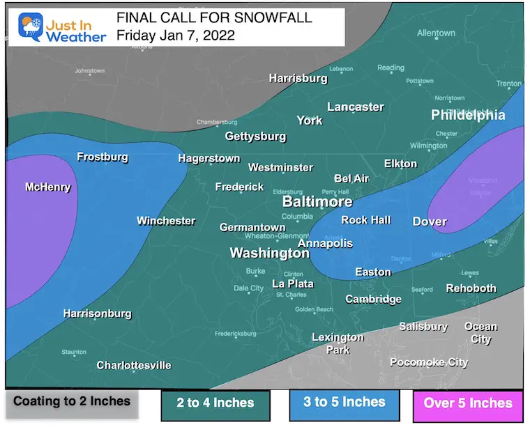
COMPARE My Final Call Map to Model Snow Plots
My Final Call For Snowfall
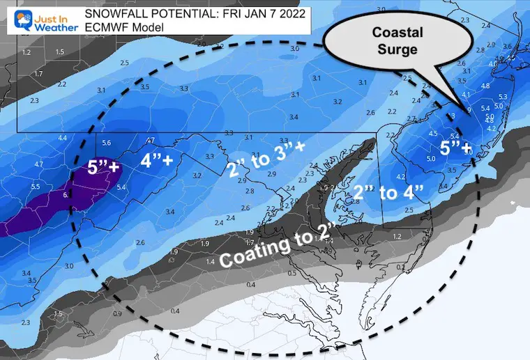
I made a slight adjustment to the higher snow zone.. This still accounts for the influence of the coastal Low. I’ve included Annapolis and central Delmarva based off Atmospheric Memory.
I’ve shaved the southern zones due to track and location of warmer air.
Model Snow Forecast Maps
European Model
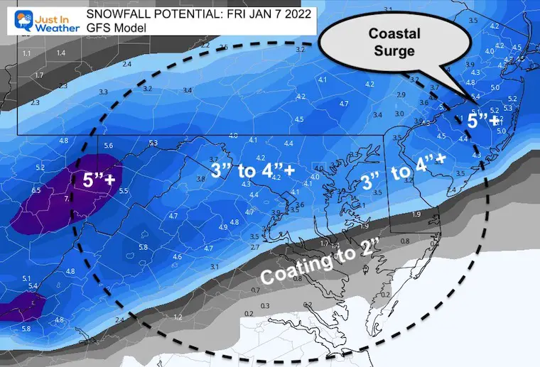
GFS Model
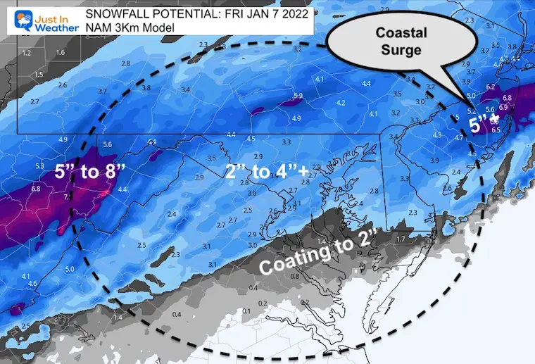
NAM 3 Km
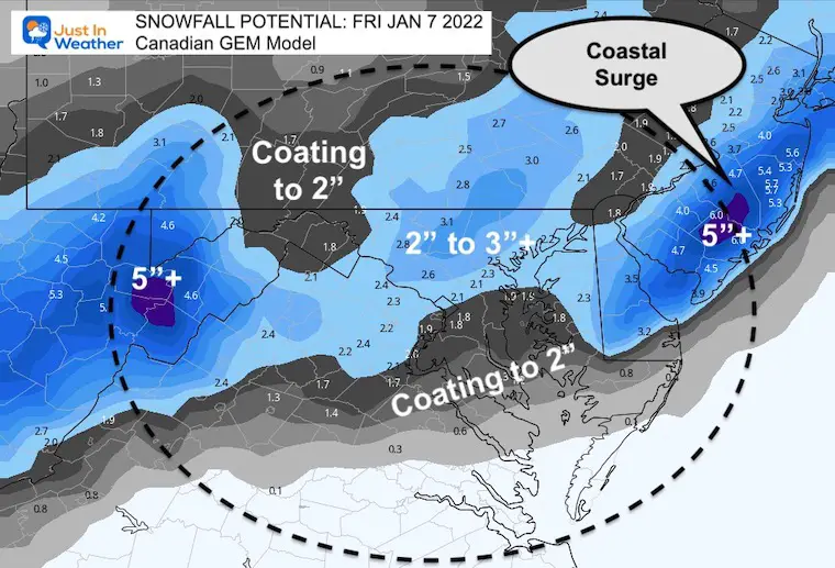
Canadian GEM
See Regional NWS Snow Maps
Click To Explore the latest ‘Official’ plus Low and High End potential snowfall.
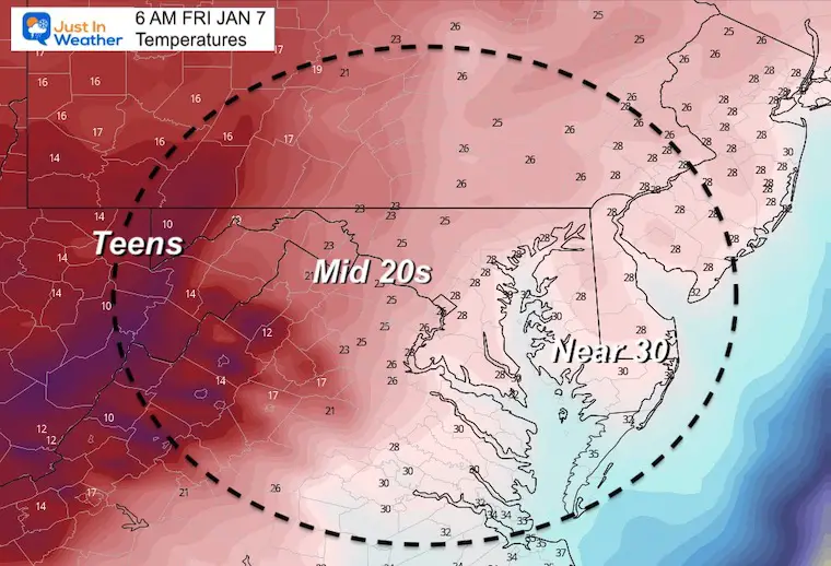
Morning Temperatures
Reminder that it will get colder with the snowfall and remain in the upper 20s for most into the morning. Snow stickage will be widespread.