Monday Night Update February 12
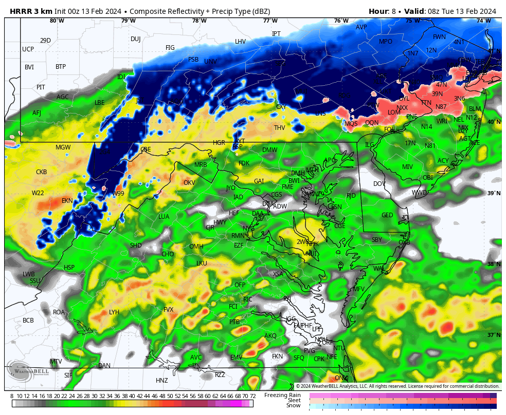
The storm moving in overnight will be rapidly developing as it crosses our region. With this intensification, it will generate its own cold air, pulling it down to the surface as heavy rain changes to a burst of snow.
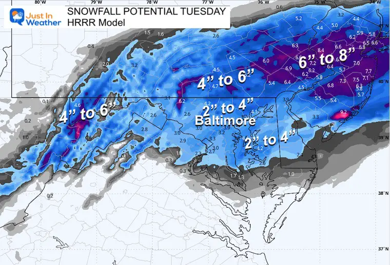
The snowfall rates may be 1 inch per hour or more, however, it will be battling the warm ground for stickage.
I wanted to share the high-resolution HRRR Model simulation for a good suggestion on the timing. The amount of snow that may lay, stay, and accumulate will be a challenge. The wet snow will melt on warmer ground. After the heavy rate overtakes the melting for stickage, the compression of the heavy snow AND some additional melting will make for a slushy mess that will measure less than what actually falls.
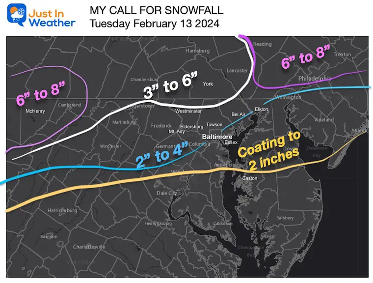
Below is my estimated call with the latest model and NWS snow maps.
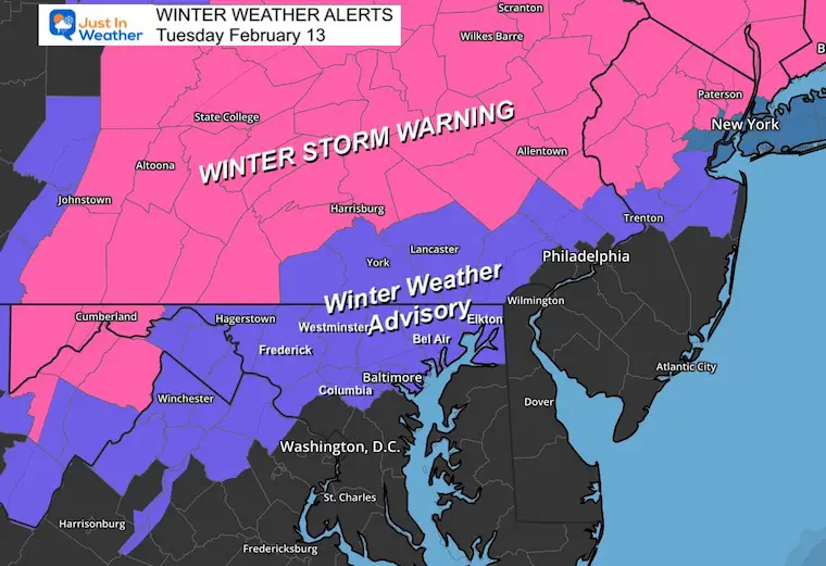
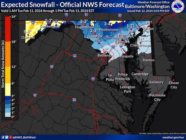
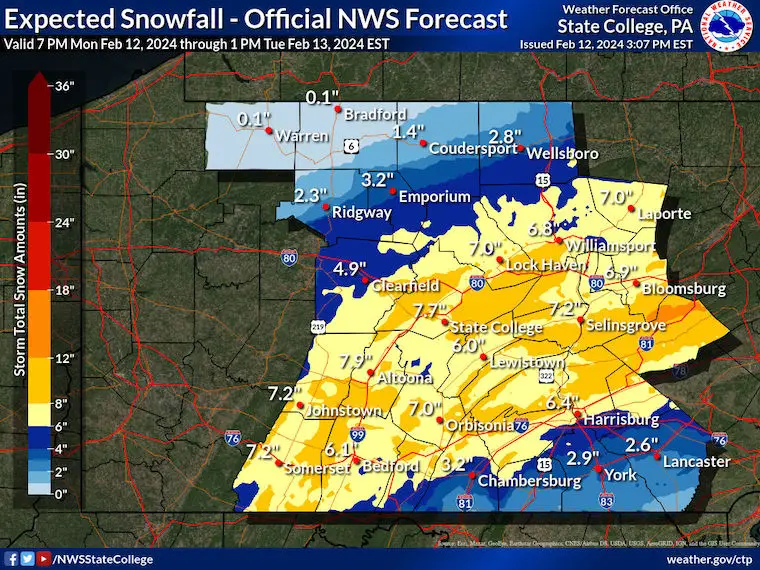
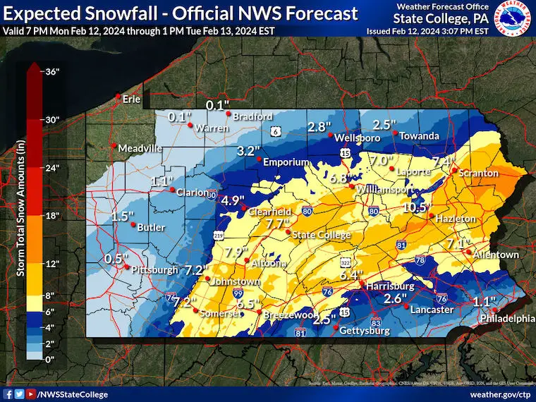
Winter Weather Advisory/Winter Storm Warning
Snow maps below.
The Winter Weather Advisory: Snow 1 to 3 inches
- Central Maryland, including the colder areas from Hagerstown, Frederick, Westminster, and the Hereford Zone
- Metro areas around Baltimore, Columbia, Bel Air, and Elkton along I-95
- Southern Pennsylvania from Gettysburg, York, and Lancaster
Winter Storm Warning: Snow 4 to 8 inches
- Maryland: Cumberland to Garrett County
- Pennsylvania around Harrisburg and NORTH!
- Also, a heads up if traveling to metro New York
Radar Simulation
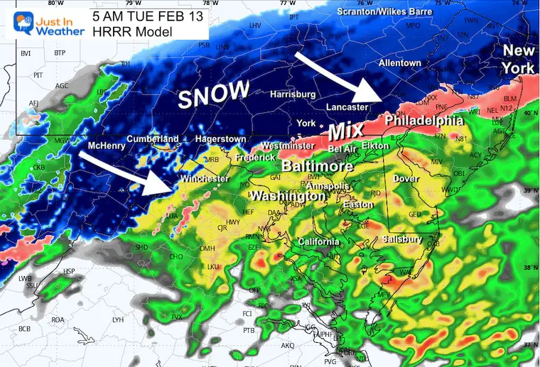
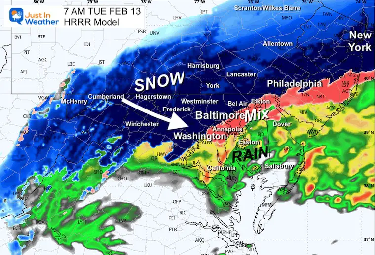
HRRR Model 3 AM to 1 PM
Snapshots
5 AM
7 AM
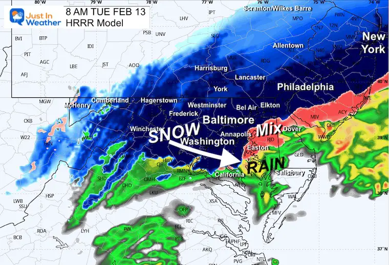
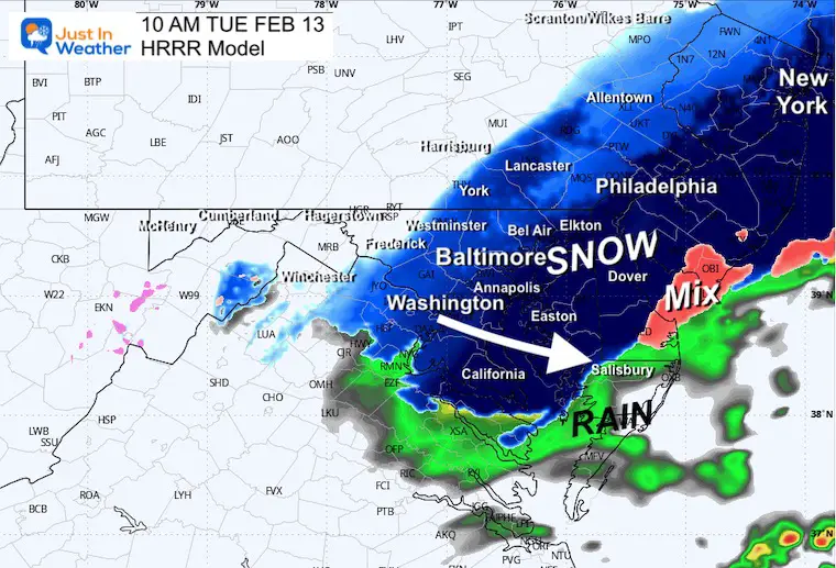
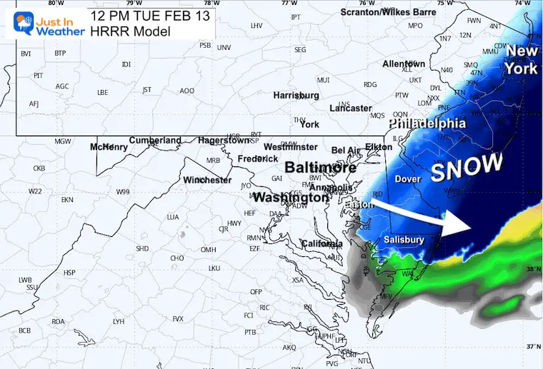
Temperatures
8 AM
10 AM
12 PM
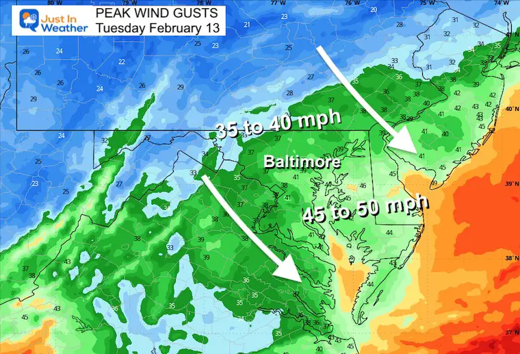
Note: It Will Turn WINDY As Well
The strengthening storm will pull in strong winds during the morning. Gusts may range from 40 mph inland to 50 mph near the coast.
HRRR Snow Total Suggestion
My Call For Snowfall
Other Snowfall Maps
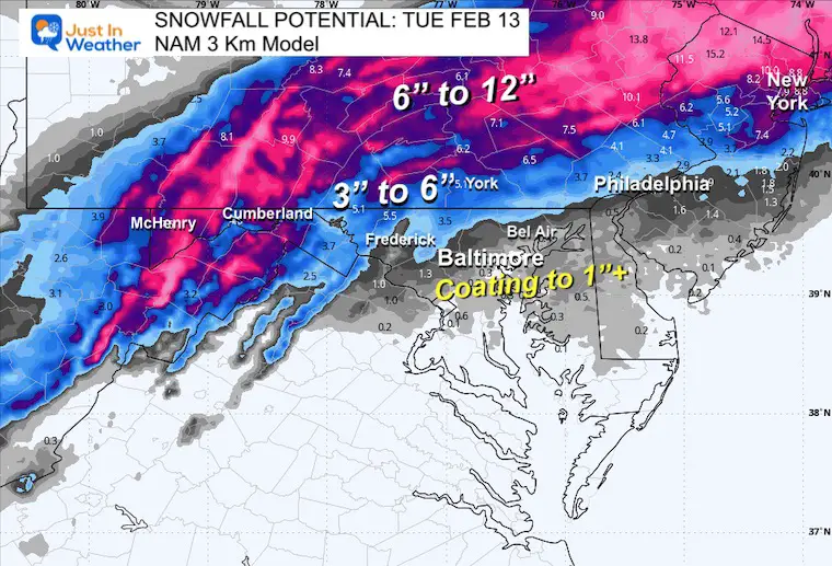
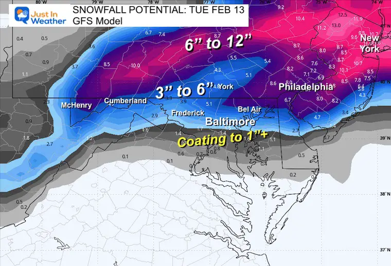
Computer Model Guidance
NAM 3 Km
GFS Model
National Weather Service
Maryland
Pennsylvania
Central State
Full State
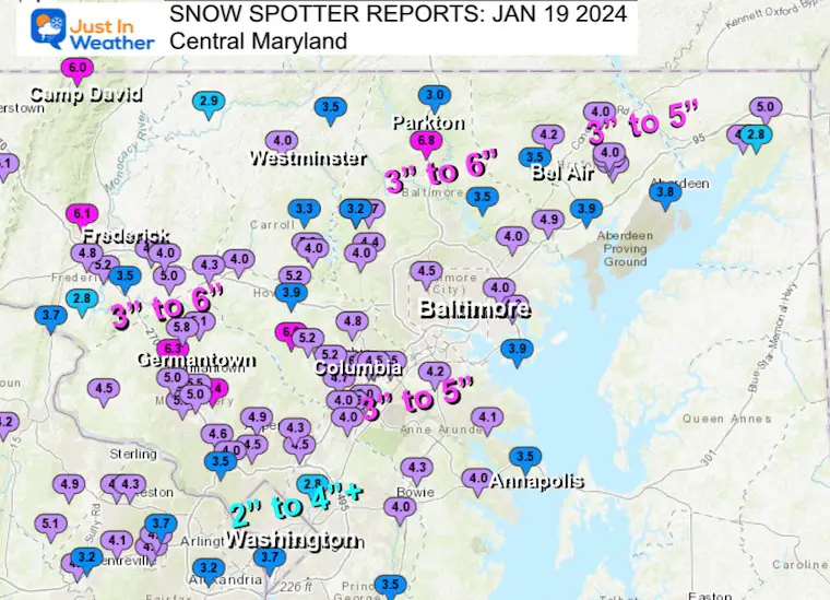
Recent Snow Reports
January 19 Recap
Click here for the maps and full report
Jan 16 Snow Report
Click here or the map to see: The Snow Report Ending Jan 16

Subscribe for eMail Alerts
Explore More
Maryland Snow Climate History And Other Winter Pages

STEM Assemblies/In School Fields Trips Are Back
Click to see more and ‘Book’ a visit to your school
RECENT Winter Outlook Reports:

Faith in the Flakes Gear

El Niño Winter Updates

Computer Models Support East Coast Storm Track

El Niño Advisory
The latest NOAA report is confident in a Very Strong event. Possibly HISTORIC! This refers to the temperatures in the Pacific, with impacts on the US Winter Storm Track.

Winter Weather Folklore: Top 20 and more signals from nature for snow.
NOAA’s Winter Outlook 2024
Winter Outlook 2024 From Two Farmers Almanacs Return to Cold and Snow
Please share your thoughts and best weather pics/videos, or just keep in touch via social media
RESTATING MY MESSAGE ABOUT DYSLEXIA
I am aware there are some spelling and grammar typos and occasional other glitches. I take responsibility for my mistakes and even the computer glitches I may miss. I have made a few public statements over the years, but if you are new here, you may have missed it: I have dyslexia and found out during my second year at Cornell University. It didn’t stop me from getting my meteorology degree and being the first to get the AMS CBM in the Baltimore/Washington region. One of my professors told me that I had made it that far without knowing and to not let it be a crutch going forward. That was Mark Wysocki, and he was absolutely correct! I do miss my mistakes in my own proofreading. The autocorrect spell check on my computer sometimes does an injustice to make it worse. I also can make mistakes in forecasting. No one is perfect at predicting the future. All of the maps and information are accurate. The ‘wordy’ stuff can get sticky. There has been no editor who can check my work when I need it and have it ready to send out in a newsworthy timeline. Barbara Werner is a member of the web team that helps me maintain this site. She has taken it upon herself to edit typos when she is available. That could be AFTER you read this. I accept this and perhaps proves what you read is really from me… It’s part of my charm. #FITF


