


January 16 A Chance For Light Snow This Weekend In Different Parts Of Our Region Each Day
Friday January 16 There is a lot to talk about this morning in all directions. The deep freeze has reached Florida, with parts of it in the 20s and snow…
January 26 2024
Friday Morning Update
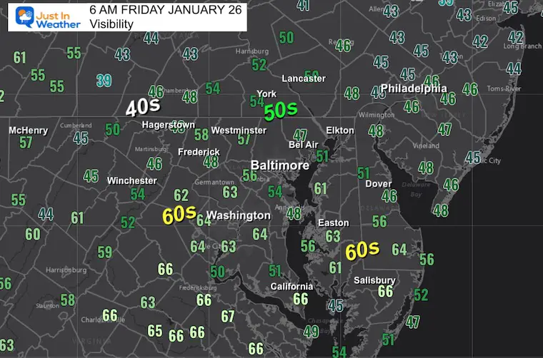
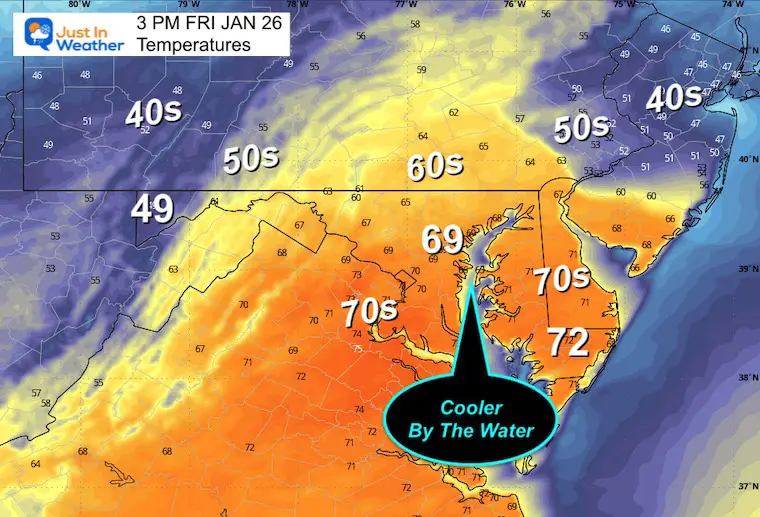
Very thick fog has prompted advisories this morning. This is the leading edge of warm air that will flow in today. WE can expect some breaks of sun and a surge to the mid 60s or even some 70s.
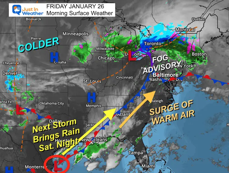
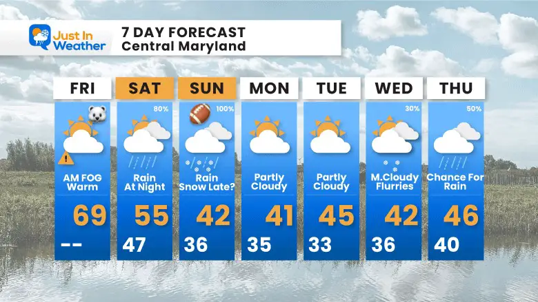
Cooler air will return tonight to set the stage for the next event: Moderate to heavy rain Saturday night into Sunday. The AFC Championship does look wet and cool in the 40s… And wet snow may arrive in Baltimore by the end of the game.
In Case You Missed This…
An incredible optical illusion of the Chesapeake Bay Bridge on Thursday. The fog made it appear as if the bridge was sinking into the water.
Visibility UNDER 1 mile. As the warmer air moves in, the fog and advisories may get eroded away from south to north.
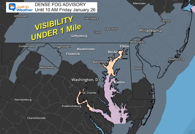
Under 1 mile visibility near Annapolis to Baltimore and north. The clearing or improved visibility is noticeable to the south.
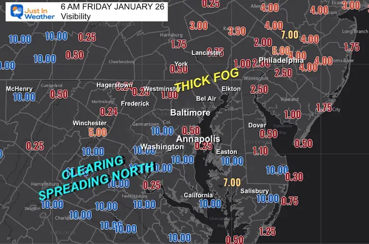
Check out the 60s to the south, where the visibility has improved.
The current storm pattern is pushing very warm air into our region. The thick fog is on the leading edge… Once that clears out, we may get a partly sunny sky that will surge the temps this afternoon.
The next wave of Low Pressure will send moderate to heavy rain our way by Saturday night into Sunday.
Inland areas will reach the mid-60s to near 70ºF! It will be cooler by the water.
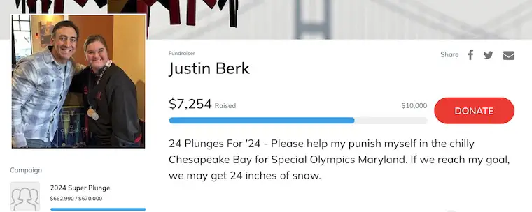
Thanks for so much support; I have pushed ABOVE 70% of my goal!
Here is my WHY I posted on Facebook last night
This Friday, I will be doing 24 plunges in 24 hours at Sandy Point Park.
I hope you will consider supporting my efforts to reach this lofty goal!
This is my new friend Daniele, A Special Olympics Athlete and my inspiration!
Click the image to donate. Every little bit counts.
Sunrise at 7:19 AM
Sunset at 5:20 PM
Normal Low in Baltimore: 25ºF
Record 2ºF in 1961
Normal High in Baltimore: 43ºF
Record 79ºF 1950
SEASONAL SNOW at BWI
9.1 inches
Click here for the maps and full report
Click here or the map to see: The Snow Report Ending Jan 16

It will be cooler with rain arriving at night.
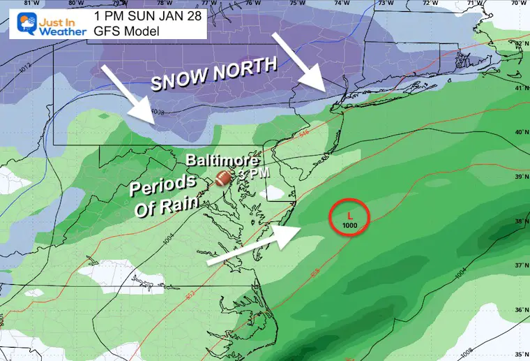
This GFS Model is showing the developing rain Saturday night, then periods or waves of rain on Sunday. This model continues to bring in colder air and maybe snow. At this time, it looks faster, and that changeover could occur by Sunday night and end before Monday morning.
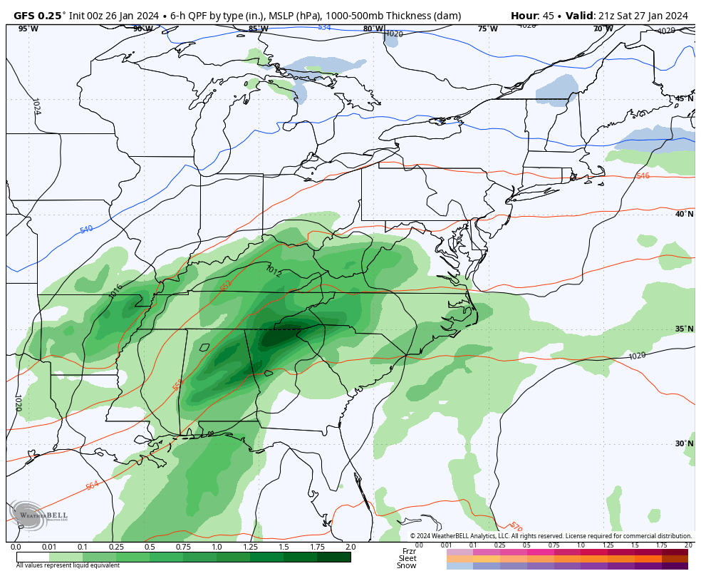
Baltimore will have periods of rain.
Temps will be cooling in the 40s…
The speed of this system now looks like that mix to wet snow may arrive by evening or overnight. Temps will remain above freezing for the city. Some slushy accumulation is possible inland.
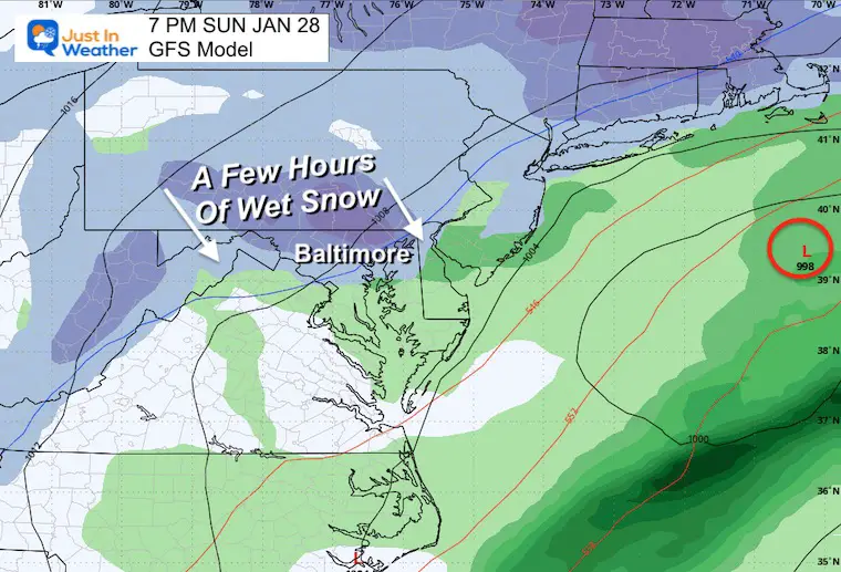
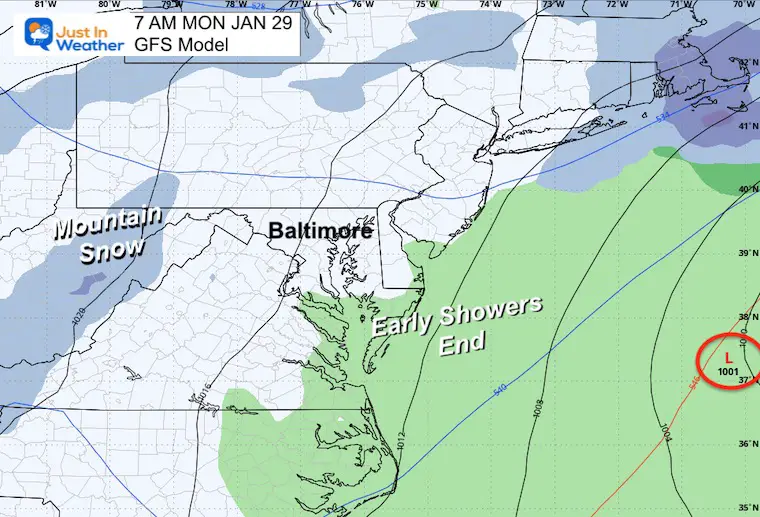
This system is following the trend to move out faster! It should be ending by this time at the beach, with snow showers in the mountains.
Maryland Special Olympic Super-Plunge begins at 10 AM. By the water, it will be colder, but inland areas have a chance to reach the 60s to near 70ºF.
Sunday: Periods of rain, including the AFC Championship Game. It may end with a few hours of snow at night… Especially inland.
Next Week: Cooler but not cold!!
Sign up and be the first to know!

Click to see more and ‘Book’ a visit to your school


Computer Models Support East Coast Storm Track

The latest NOAA report is confident in a Very Strong event. Possibly HISTORIC! This refers to the temperatures in the Pacific, with impacts on the US Winter Storm Track.

Winter Weather Folklore: Top 20 and more signals from nature for snow.
Winter Outlook 2024 From Two Farmers Almanacs Return to Cold and Snow
I am aware there are some spelling and grammar typos and occasional other glitches. I take responsibility for my mistakes and even the computer glitches I may miss. I have made a few public statements over the years, but if you are new here, you may have missed it: I have dyslexia and found out during my second year at Cornell University. It didn’t stop me from getting my meteorology degree and being the first to get the AMS CBM in the Baltimore/Washington region. One of my professors told me that I had made it that far without knowing and to not let it be a crutch going forward. That was Mark Wysocki, and he was absolutely correct! I do miss my mistakes in my own proofreading. The autocorrect spell check on my computer sometimes does an injustice to make it worse. I also can make mistakes in forecasting. No one is perfect at predicting the future. All of the maps and information are accurate. The ‘wordy’ stuff can get sticky. There has been no editor who can check my work when I need it and have it ready to send out in a newsworthy timeline. Barbara Werner is a member of the web team that helps me maintain this site. She has taken it upon herself to edit typos when she is available. That could be AFTER you read this. I accept this and perhaps proves what you read is really from me… It’s part of my charm. #FITF