


May 2 One More Hot Day Then The Cool Down And Rain For The Weekend
Thursday May 2 Morning Report This is one of those days where we get a little surprise. The old air mass is holding strong and will allow one more hot…
Tuesday January 16 2024
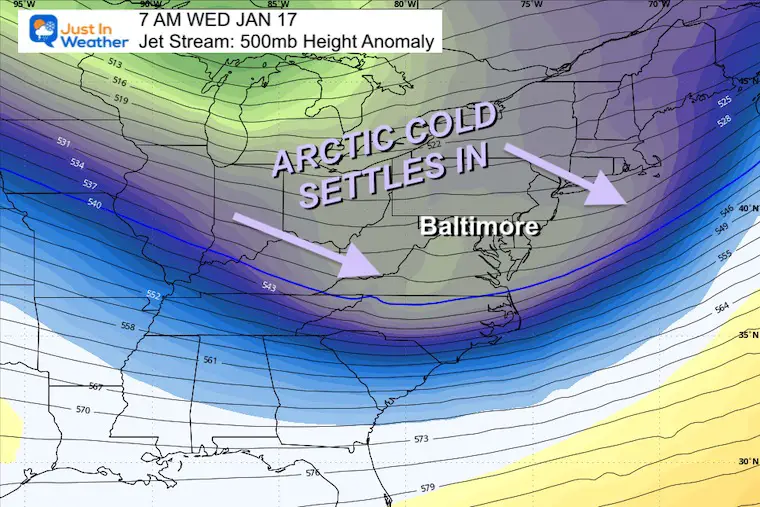
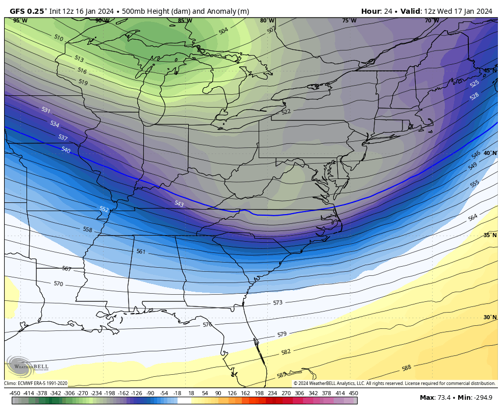
With the recent record snow in Baltimore and ending the snow drought for the region, we have set the stage for the arctic air to settle in without obstruction. Wednesday will end up in the deep freeze and help some reservoirs and northern Chesapeake Bay start to develop ice.
Looking out the next few days, we see another weather system work with the cold air to bring anther round of snow.
The trend is your friend! That is a motto that I have seen for decades and falls in line with my Atmospheric Memory Theory. I can not promise an exact repeat, but a similar set up for snow may develop early on Thursday and last into Friday with impact.
Considering that we will spend the week below freezing and with fresh snow pack, the ground will be primed for maximum stickage.
Let’s take a look:
Click here or the map to see: The Snow Report Ending Jan 16

High Pressure in Tennessee will bring the arctic air to the east coast. With Northwest winds and plenty of fresh snowpack, it will arrive unobstructed.
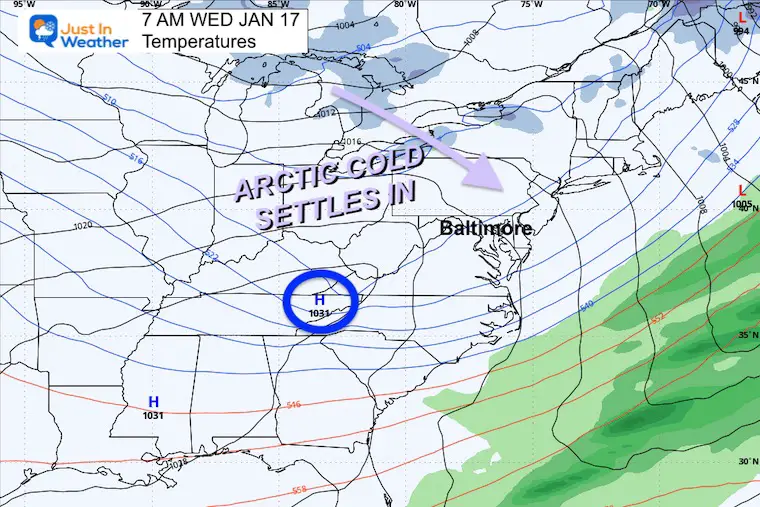
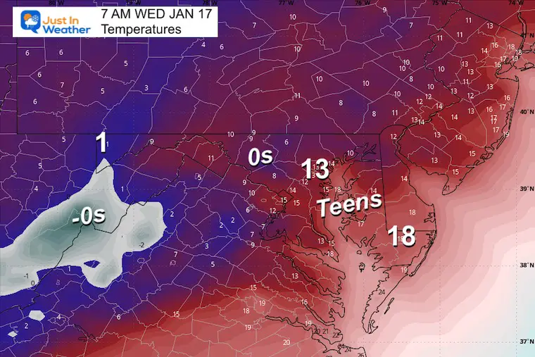
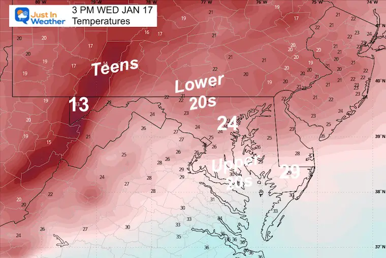
Forecast temperatures expected on the thermometers…. Not the wind chill.
DEEP FREEZE: Max temps will remain in the middle to lower 20s in central Maryland.
The push of arctic air will get another reinforcement at the end of the week. This shortwave in the jet stream will try to develop Low Pressure and another round of snow.
The core of the next arctic air mass will arrive after another round of snow. This may actually be colder Saturday morning.
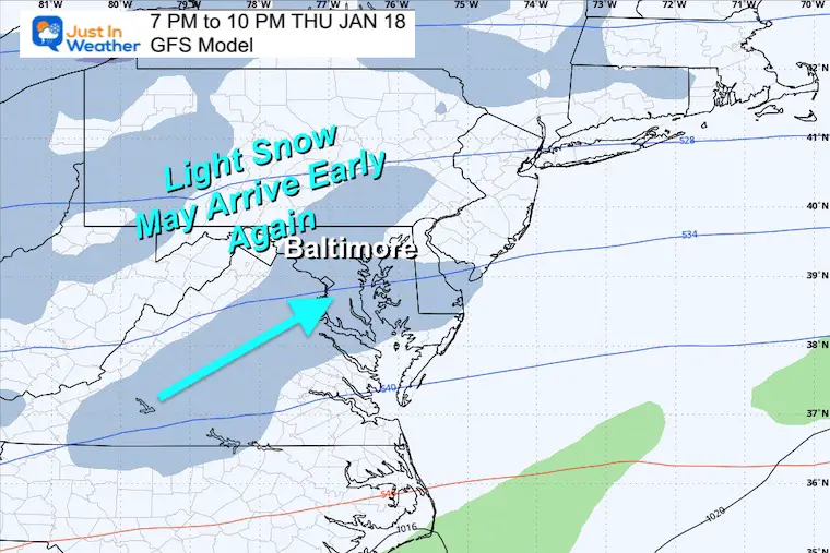
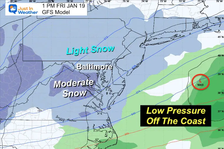
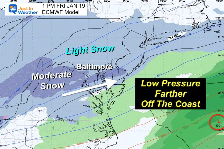
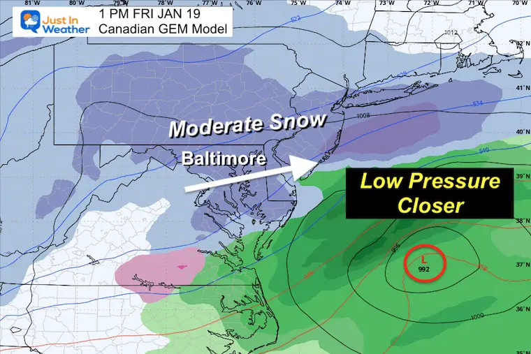
When I mentioned a repeat… This is not the same streak of winds aloft, but there is energy that may translate to an earlier band of light snow Thursday … similar to what we saw Monday.
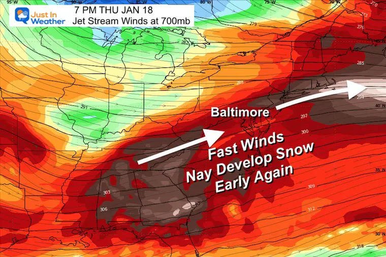
The upper level winds might translate to light snow developing a day ahead of the main Surface event.
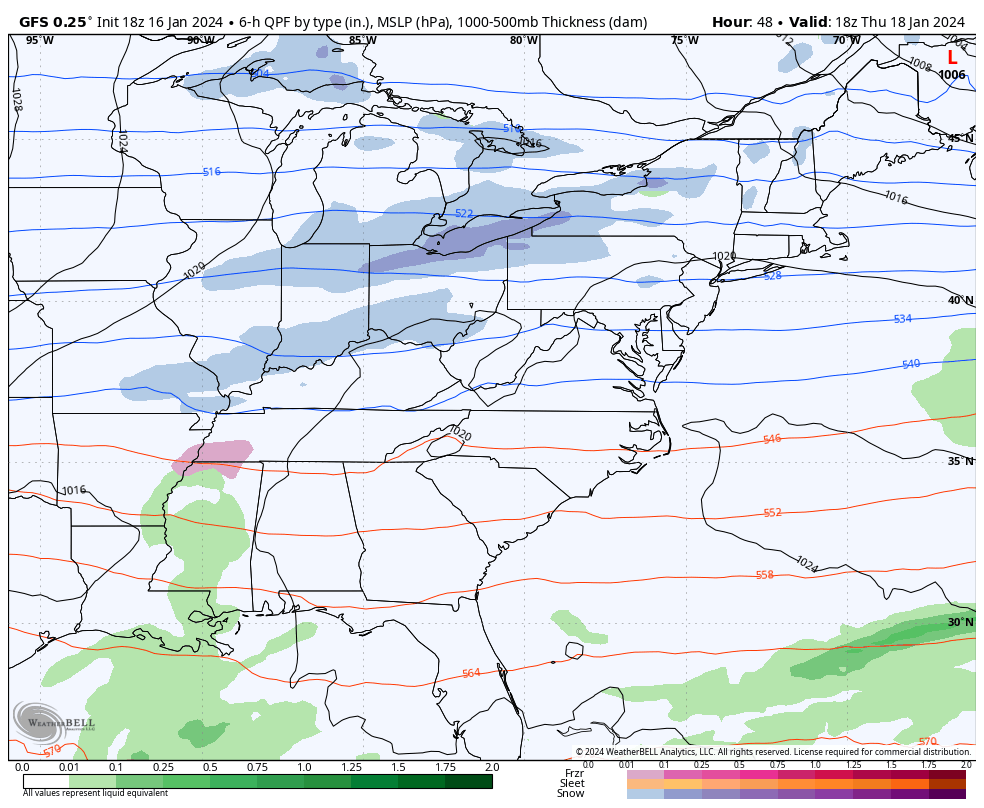
This is similar to the last set up, and as we will see below there are different results among the three main models.
The energy is not lined up currently.
However, I have seen a trend for systems to speed up and pull back the surface Low to the west. IF the happens this time, there is a chance for the next few model runs to look more impressive for Friday snow.
I will not promise that, but will be looking for that trend. The Canadian GEM model is leading the way with that logic now. See below.
Stand By For Any Trend In My Next Report.
Thanks to Sue Steinbrook for sharing this beauty.


Computer Models Support East Coast Storm Track

The latest NOAA report is confident in a Very Strong event. Possibly HISTORIC! This refers to the temperatures in the Pacific, with impacts on the US Winter Storm Track.

Winter Weather Folklore: Top 20 and more signals from nature for snow.
Winter Outlook 2024 From Two Farmers Almanacs Return to Cold and Snow


Click to see more and ‘Book’ a visit to your school

I am aware there are some spelling and grammar typos and occasional other glitches. I take responsibility for my mistakes and even the computer glitches I may miss. I have made a few public statements over the years, but if you are new here, you may have missed it: I have dyslexia and found out during my second year at Cornell University. It didn’t stop me from getting my meteorology degree and being the first to get the AMS CBM in the Baltimore/Washington region. One of my professors told me that I had made it that far without knowing and to not let it be a crutch going forward. That was Mark Wysocki, and he was absolutely correct! I do miss my mistakes in my own proofreading. The autocorrect spell check on my computer sometimes does an injustice to make it worse. I also can make mistakes in forecasting. No one is perfect at predicting the future. All of the maps and information are accurate. The ‘wordy’ stuff can get sticky. There has been no editor who can check my work when I need it and have it ready to send out in a newsworthy timeline. Barbara Werner is a member of the web team that helps me maintain this site. She has taken it upon herself to edit typos when she is available. That could be AFTER you read this. I accept this and perhaps proves what you read is really from me… It’s part of my charm.
#FITF