


Soggy Saturday Update: Rain Timeline Through Preakness In Baltimore
Friday, May 17, 2024 As we approach another weekend, we have yet another weather system bringing us rain. This will make 16 of 20 weekends this year with some wet…
October 4, 2023
Wednesday Morning Update
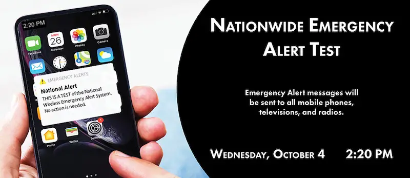
While our weather pattern is on repeat with some morning fog and sunny afternoons, there are changes on the way. Perhaps the best part of this warm afternoon may send more people outside when FEMA and the FCC perform their National Emergency Alert Test.
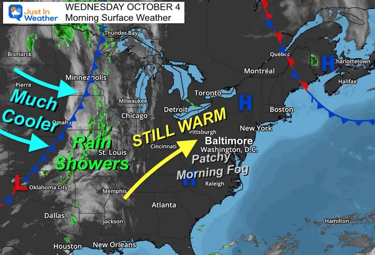
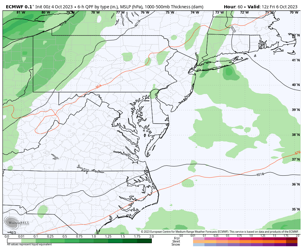
The next weather system will bring us rain showers on Friday and more likely periods of rain on Saturday.
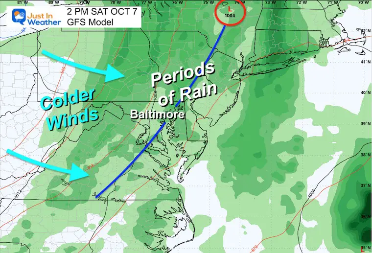
This has added a higher alert in Baltimore for the Orioles first home playoff game. There are still some details not set yet such as their opponent and the time of the game. So we can’t dig too deep into the weeds yet. If you have other outdoor plans you should consider periods of rain, which will usher in colder winds to end the weekend.
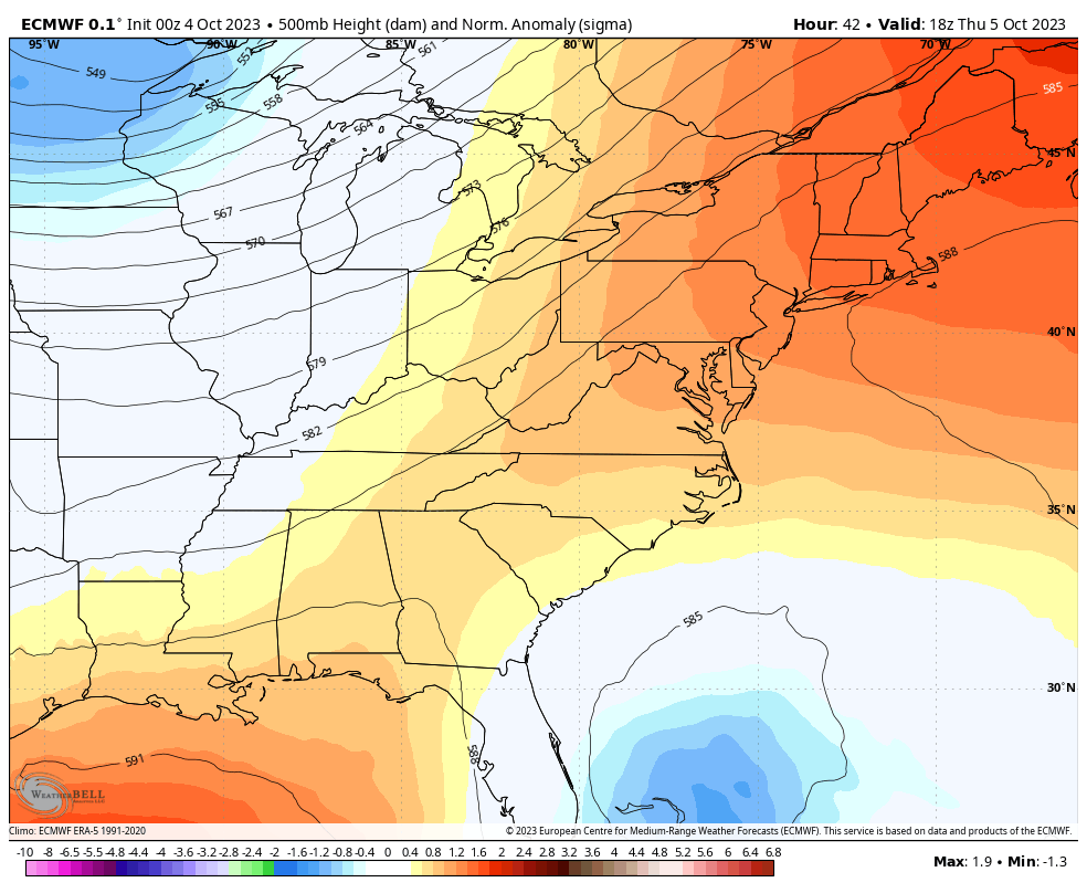
High Pressure is still in control. The cold front that will bring in our change is getting closer. This will help stream in more clouds starting tomorrow.
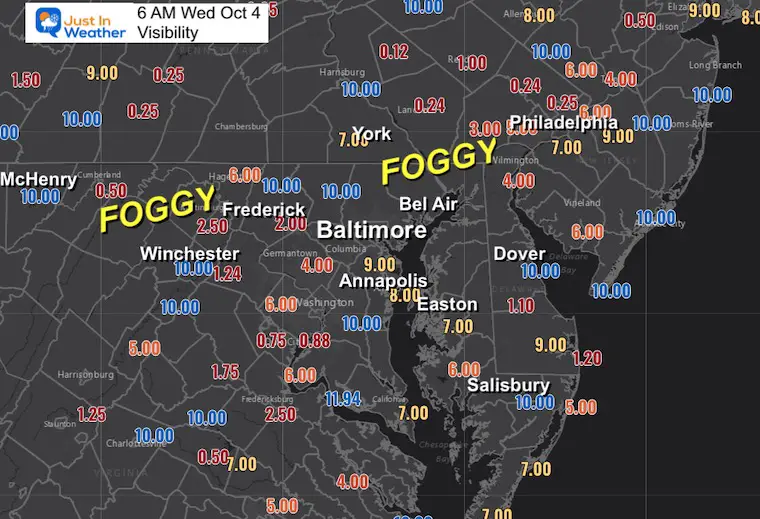
This gives an idea of where the fog has been developing and is more likely to impact traffic.
Once again the fog is pronounced around Frederick.
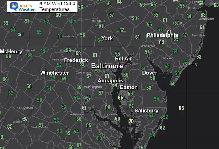
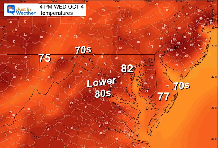
This does have a summer feel to the air and in comparison may be similar to the high temperatures we will see to end the weekend.
This afternoon starting at 2:20 PM, there will be a test of the Emergency Alert System on mobile devices, TVs, and Radio.
If you are in a public place, this may ping everyone’s phone at once.
If you turn yours off, you should get the alert when you turn it back on.
Much like yesterday, many areas will reach into the lower 80s.
Sunrise at 7:05 AM
Sunset at 6:45 PM
Normal Low in Baltimore: 51ºF
Record 31ºF in 1974
Normal High in Baltimore: 73ºF
Record 92ºF 1954
If your area is prone to morning fog (by the bay, a reservoir, or valley) you may see some to start the day. Then the sun will dominate and warm the afternoon up quickly

The cold front will help ignite scattered showers on Friday, and periods of rain are likely on Saturday.
The Orioles’ first home playoff game is scheduled for Saturday but is not set yet as they are waiting for the winner of the first series. So looking for the more likely timing of the rain may be an exercise in futility for two reasons:
I am seeing a difference across models as to whether the rain is more likely in the morning or evening. This is subject to change as we get closer. It depends on the speed of the cold front.
When we get a firm time for the game, we can focus on that.
If you have a camping trip or other outdoor event, plan for periods of rain and colder winds.
Jet Stream Animation: Thursday to Next Monday
The approaching trough is easy to spot here as it digs deep across the Eastern US. This is what will bring us the true Fall Feel by Sunday.
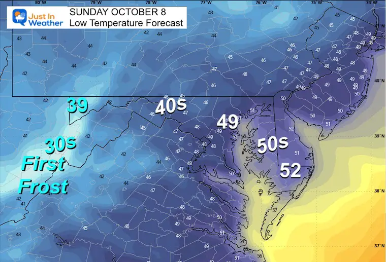
The core of the colder air will be in place by this time.
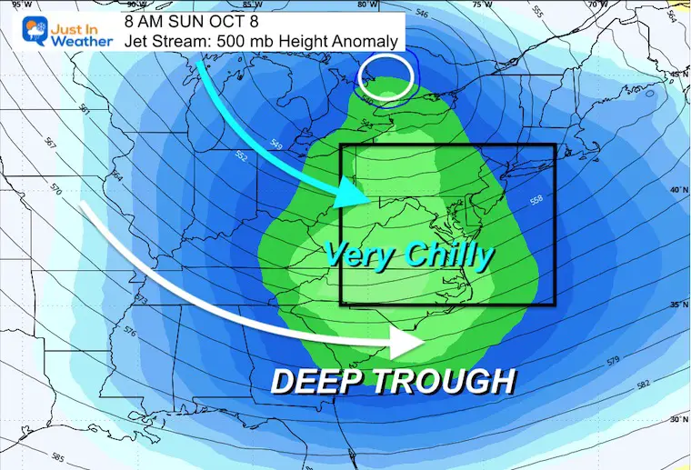
Colder temperatures will settle in, but to be fair and moderate the realistic approach is most of us inland will settle in the 40s. There will be 30s in the higher inland mountains where the first frost of the season is likely to occur.
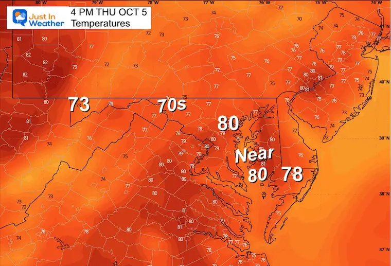
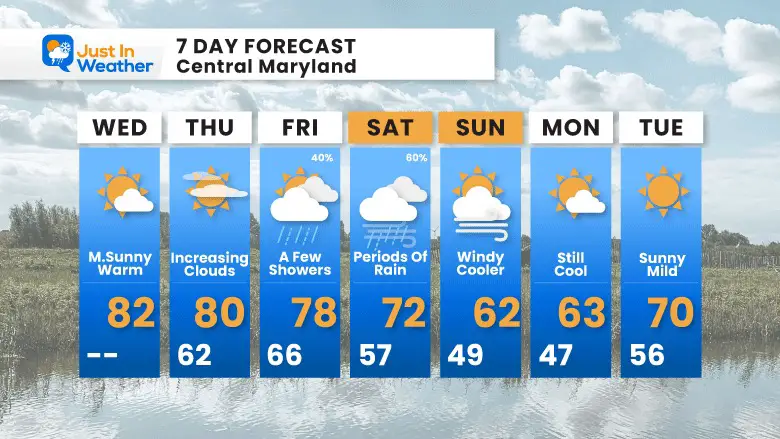
Still feeling like summer this afternoon, then we look for increasing clouds on Thursday.
Friday brings in some showers, with a better chance of rain on Saturday. This will come with a chilly wind and the colder air settles in on Sunday and Monday.

I am aware there are some spelling and grammar typos and occasional other glitches. I take responsibility for my mistakes and even the computer glitches I may miss. I have made a few public statements over the years, but if you are new here, you may have missed it: I have dyslexia and found out during my second year at Cornell University. It didn’t stop me from getting my meteorology degree and being the first to get the AMS CBM in the Baltimore/Washington region. One of my professors told me that I had made it that far without knowing and to not let it be a crutch going forward. That was Mark Wysocki, and he was absolutely correct! I do miss my mistakes in my own proofreading. The autocorrect spell check on my computer sometimes does an injustice to make it worse. I also can make mistakes in forecasting. No one is perfect at predicting the future. All of the maps and information are accurate. The ‘wordy’ stuff can get sticky. There has been no editor who can check my work when I need it and have it ready to send out in a newsworthy timeline. Barbara Werner is a member of the web team that helps me maintain this site. She has taken it upon herself to edit typos when she is available. That could be AFTER you read this. I accept this and perhaps proves what you read is really from me… It’s part of my charm.
#FITF