September 14, 2023
Thursday Morning Update
The winds have shifted and it will be noticeable today if you have not felt it yet. Cooler air and lower humidity brings a taste of autumn to end the week with an air mass that is helping to keep Hurricane Lee well off our coast.
We will track the storm and impact for our region. It still will work with the new air mass to increase the cooler winds and high waves off the coast. That is about all we will get from it. The storm is more of a New England Concern.
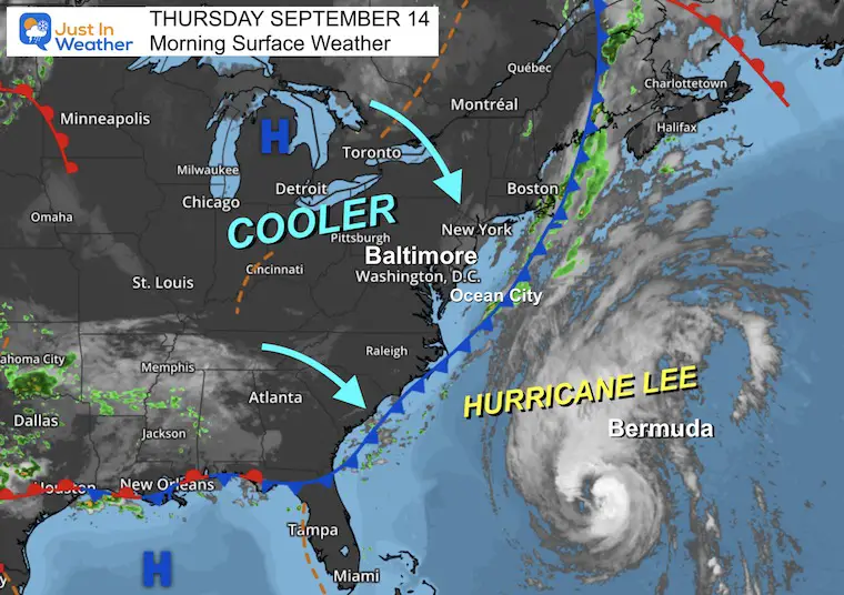
Morning Surface Weather
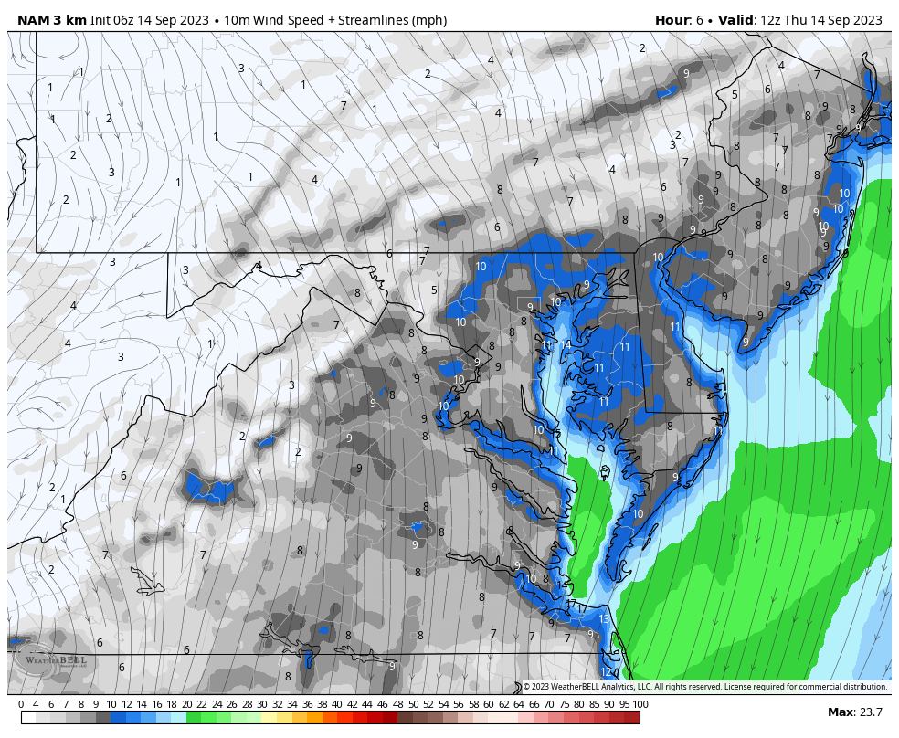
The cold front is off the coast as a cooler air mass expands into our region. It will be breezy and feel a little like Fall for a few days.
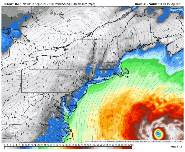
Hurricane Lee is showing up on our surface map, well off the coast. This is affecting Bermuda today and will impact New England this weekend.
The local impact will be minimal. A closer look at that below.
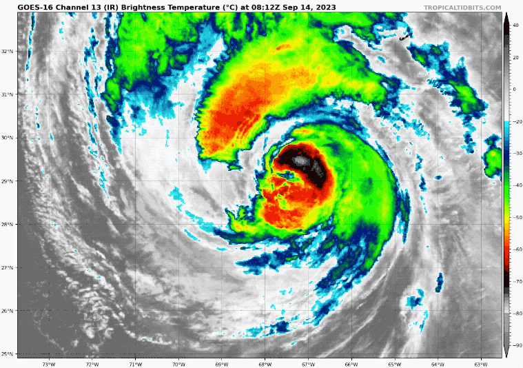
Hurricane Lee Satellite Loop
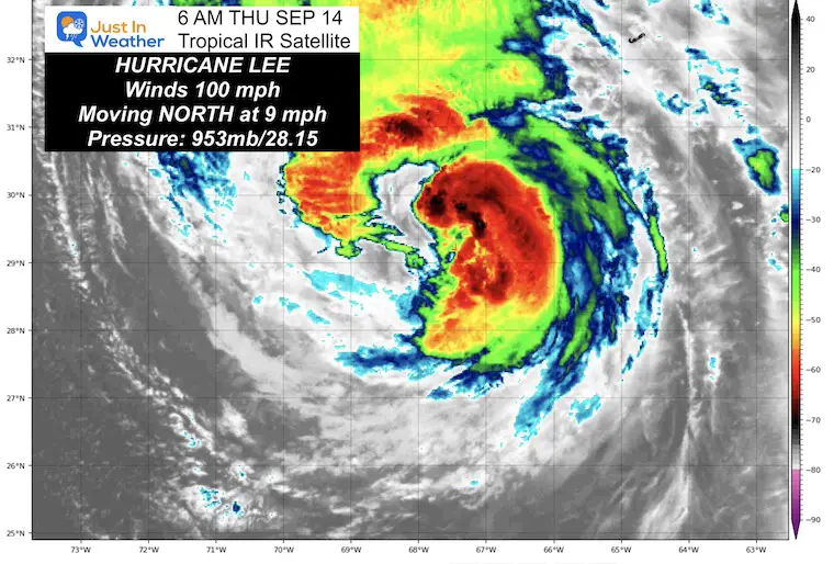
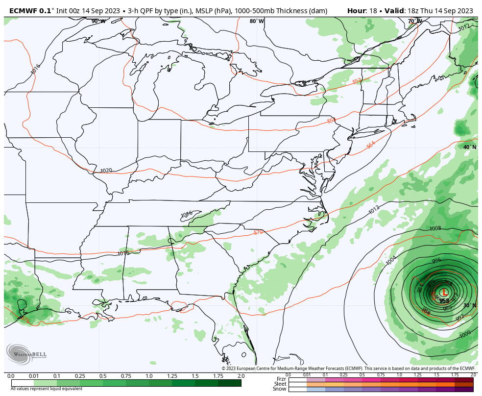
Holding at Category 2, Hurricane Lee has winds of 100 mph. This is now showing signs of spreading out as it moves north, which will be followed by weakening.
- Hurricane Force Winds reach 105 miles from the center.
- Tropical Storm Force Winds reach 290 miles from the center.
National Hurricane Center Advisory
5 AM Update
- LOCATION…29.1N 68.1W
- ABOUT 295 MI…475 KM SW OF BERMUDA
- ABOUT 840 MI…1355 KM S OF NANTUCKET MASSACHUSETTS
- MAXIMUM SUSTAINED WINDS…100 MPH…155 KM/H
- PRESENT MOVEMENT…N OR 350 DEGREES AT 9 MPH…15 KM/H
- MINIMUM CENTRAL PRESSURE…953 MB…28.15 INCHES
SUMMARY OF WATCHES AND WARNINGS IN EFFECT:
A Hurricane Watch is in effect for…
- Stonington, Maine to the U.S./Canada border
- New Brunswick from the U.S./Canada border to Point Lepreau, including Grand Manan Island
- Nova Scotia from Digby to Medway Harbour
A Tropical Storm Warning is in effect for…
A Tropical Storm Watch is in effect for…
- Watch Hill, Rhode Island to Stonington, Maine
- Block Island
- Martha’s Vineyard
- Nantucket
- New Brunswick from north of Point Lepreau to Fort Lawrence
- Nova Scotia west coast from north of Digby to Fort Lawrence
- Nova Scotia southeast coast from north of Medway Harbour to
- Porter’s Lake
A Storm Surge Watch is in effect for…
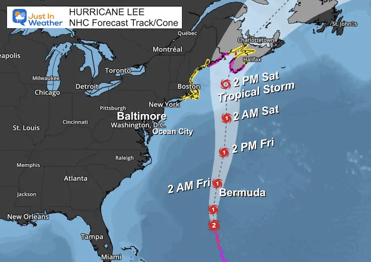
Forecast Track From The National Hurricane Center
This has shifted back to the east a little. It is also important to note that Lee is likely to be down to Tropical Storm intensity when it reaches the Gulf of Maine. Landfall may be overnight Saturday into Sunday between the Maine and Canadian Border.
Wind Forecast
Friday Noon to Saturday Night
Local Weather
Wind Today
8 AM to Midnight
Increasing wind flow during the day FROM THE NORTH, then calming this evening.
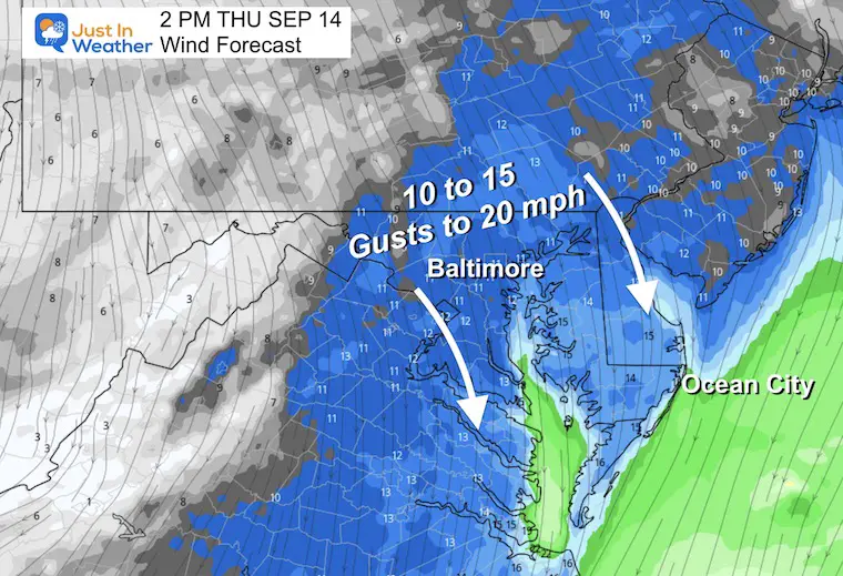
The concern for flooding on the local water may be confined to the coastal beaches. This wind direction helps move the water OUT OF THE BAY.
Small Craft Advisory is in effect for boaters on the Bay.
Snapshot at Noon
The winds FROM the north between 10 to 15 mph. Gusts up to 20 mph. This will help keep temps in the 70s for most of our region
.
Temperature Forecast
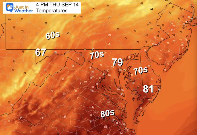
Most of the region will stay in the 70s today. Cooler 60s in the mountains while near 80 in far southern Maryland and Southeast VA.
CLIMATE DATA: Baltimore
TODAY September 14
Sunrise at 6:47 AM
Sunset at 7:17 PM
Normal Low in Baltimore: 60ºF
Record 42ºF in 1975
Normal High in Baltimore: 81ºF
Record 94ºF 1931
Subscribe for eMail Alerts
Temperature Forecast
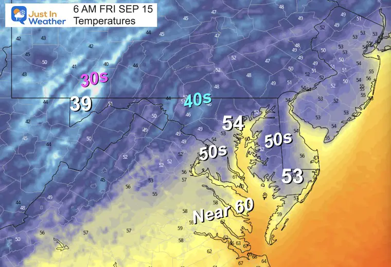
Friday Morning
This looks like an Autumn Map!
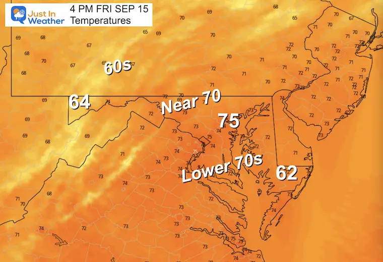
Friday Afternoon
Starting to get into cooler air.
Looking Ahead
Thursday Morning to Sunday Night
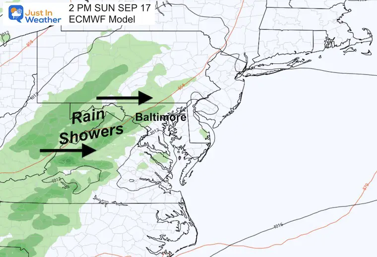
Watching Lee roll north into New England and MISSING THE MID-ATLANTIC.
The next system will be a reinforcing cold front on Sunday. This will bring in a chance of rain showers… Not connected to the hurricane.
Snapshot Sunday
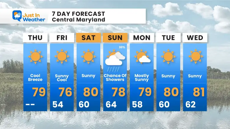
7 Day Forecast
Feeling Like Fall for a few days. The chilly mornings will modify this weekend.
EXPLORE MORE
EARLIER IN AUGUST: Maryland Trek 10 For These Kids
I will have a follow-up and recap on our amazing week shortly.

Subscribe for eMail Alerts

Please share your thoughts and best weather pics/videos, or just keep in touch via social media
RESTATING MY MESSAGE ABOUT DYSLEXIA
I am aware there are some spelling and grammar typos and occasional other glitches. I take responsibility for my mistakes and even the computer glitches I may miss. I have made a few public statements over the years, but if you are new here, you may have missed it: I have dyslexia and found out during my second year at Cornell University. It didn’t stop me from getting my meteorology degree and being the first to get the AMS CBM in the Baltimore/Washington region. One of my professors told me that I had made it that far without knowing and to not let it be a crutch going forward. That was Mark Wysocki, and he was absolutely correct! I do miss my mistakes in my own proofreading. The autocorrect spell check on my computer sometimes does an injustice to make it worse. I also can make mistakes in forecasting. No one is perfect at predicting the future. All of the maps and information are accurate. The ‘wordy’ stuff can get sticky. There has been no editor who can check my work when I need it and have it ready to send out in a newsworthy timeline. Barbara Werner is a member of the web team that helps me maintain this site. She has taken it upon herself to edit typos when she is available. That could be AFTER you read this. I accept this and perhaps proves what you read is really from me… It’s part of my charm.
#FITF


