


July 12 Very Humid With Scattered Thunderstorms Later And More Storms Tomorrow
Saturday, July 12, 2025 Morning Report This may sound familiar: We remain in the ambiguous humid air mass. There is thick fog this morning, and the sun will dominate the…
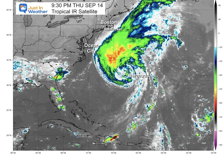
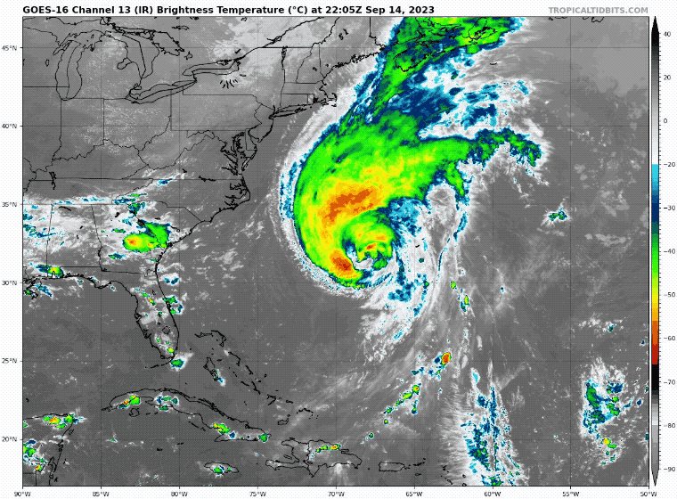
September 14 Thursday Night Update
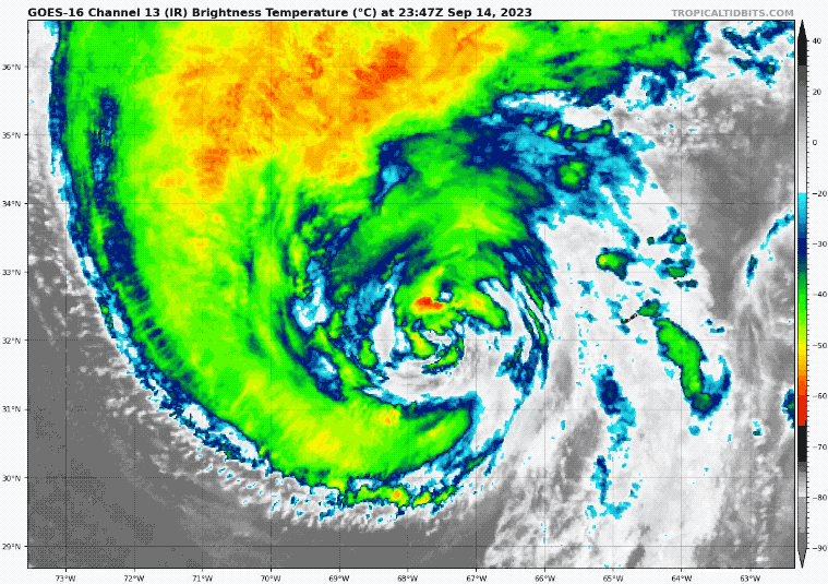
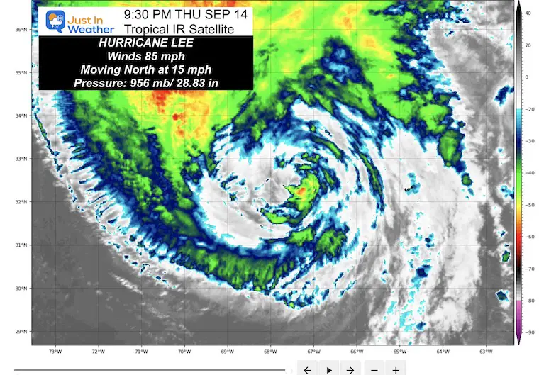
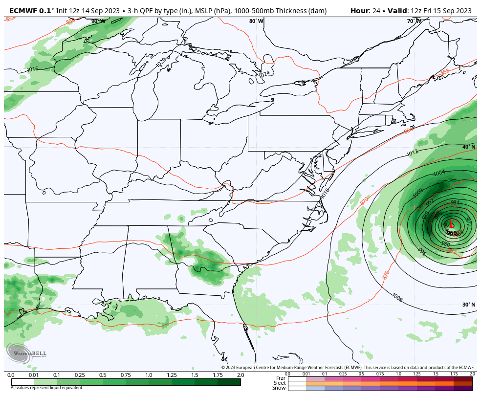
Hurricane Lee has weakened to a Category 1 storm with winds of 85 mph. This continues to behave as expected as it passes to the West of Bermuda. It is also becoming a very large storm. Winds reach 345 miles from the center!
This is still far offshore and the impact on the Mid-Atlantic will be on Friday, mainly with some wind and high waves.
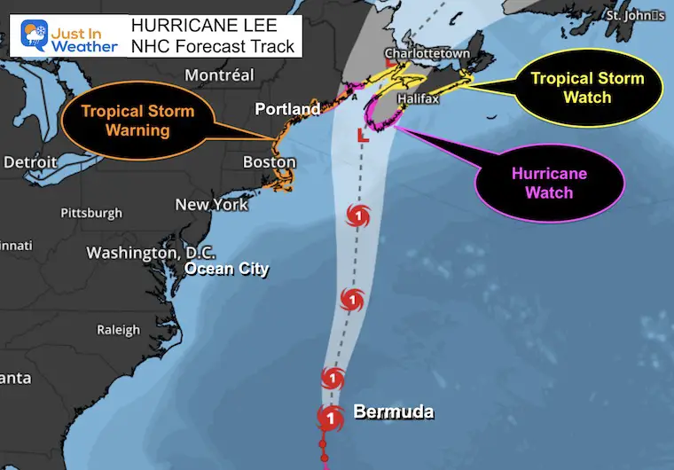
The track still has this making landfall Saturday night between Maine and Nova Scotia. My friend and former TV News Producer David McHugh is from there. The Bay of Fundy has some of the largest tidal swings in the world. I’ve seen it firsthand at Bar Harbor, Maine. David has shared some relative info I posted below.
A Tropical Storm Warning is in place for Eastern New England. There is a Hurricane Watch for parts of Nova Scotia, but this is likely to be downgraded by the time it makes landfall.
The Fall Air Mass we have on the East Coast now is what has helped to block Lee and spread it out.
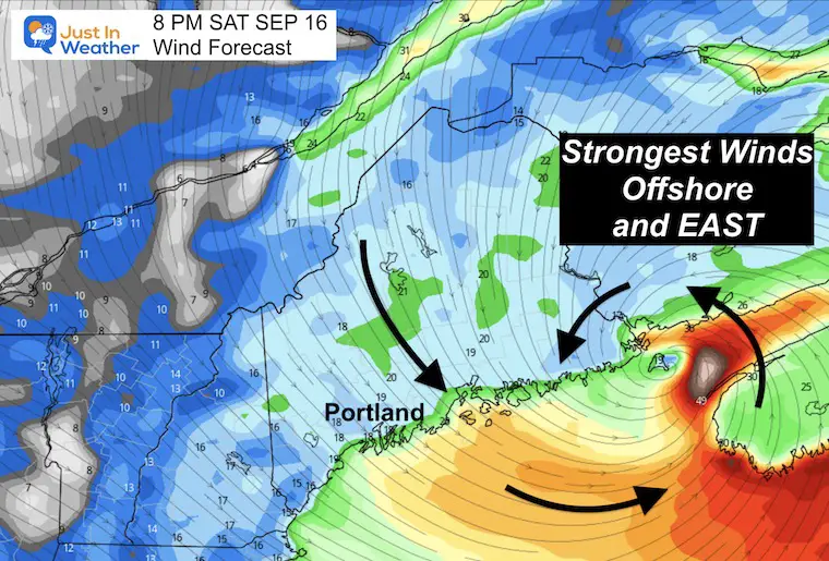
The flow of air will be FROM THE NORTH, which will help the chill in the air. Steady winds will be 10 to 20 mph with higher gusts.
With this direction, there should not be a flooding risk on the Bay, but water in the southern Chesapeake may be higher than normal.
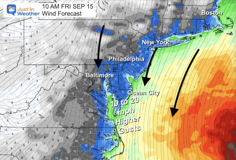
Wind gusts will be over 20 mph, even inland.
We may have wind restrictions on the bridges.

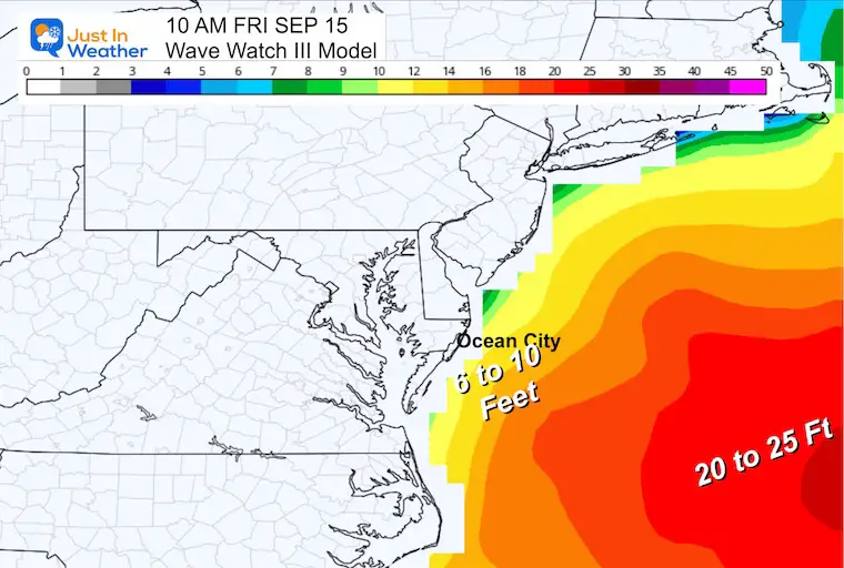
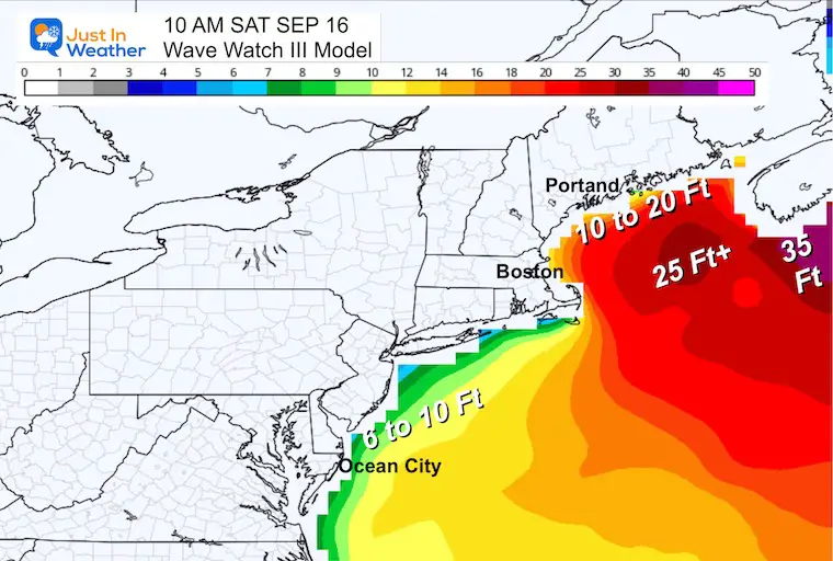
With the storm a little farther east, the wave forecast has lowered a little to 6 to 10 Feet.
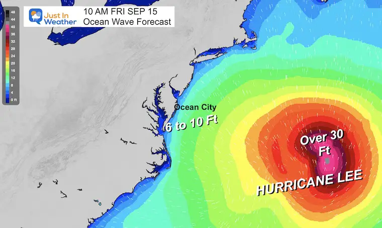
Agreement here with the wave forecast of 6 to 10 Feet.
As we discussed in earlier reports, a northward-moving tropical system will get weaker AND expand out farther:
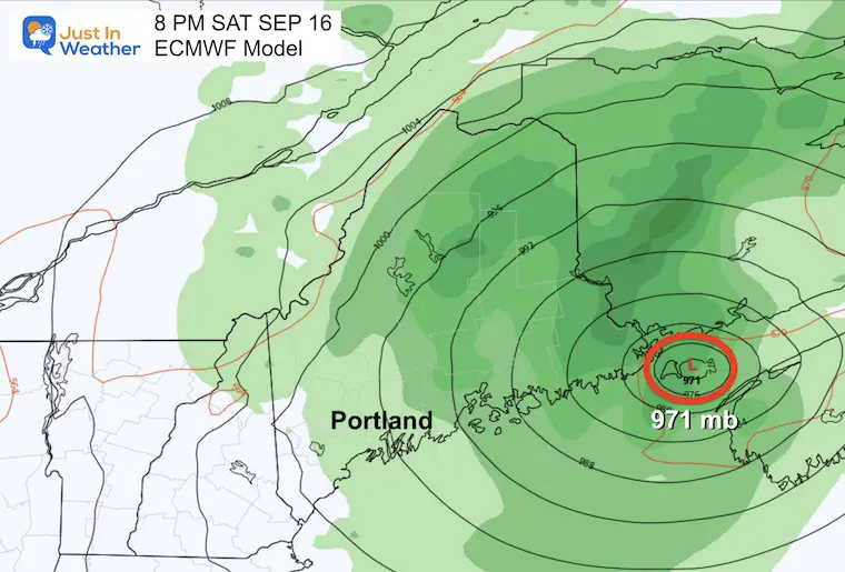
This shows the path and category strength as a Category 1 as it passes EAST of Boston. The possible landfall may be between the US and Canadian border and it could be down to a Tropical Storm at that time. It is important to note that the STRONGER SIDE is to the East of the center, so Nova Scotia will bear the brunt worse than Maine.
A Hurricane Watch is in effect for…
A Tropical Storm Warning is in effect for…
A Tropical Storm Watch is in effect for…
After once being a Category 5 Hurricane, Lee may make landfall on Saturday night. This might be down to a Tropical Storm when it reaches Canada’s Nova Scotia and rolls up the Bay of Fundy.
The circulation around the center of Lee will bring stronger winds to the East side in Canada. A North wind from the land will average 20 mph or higher in Maine, with faster winds over the ocean.
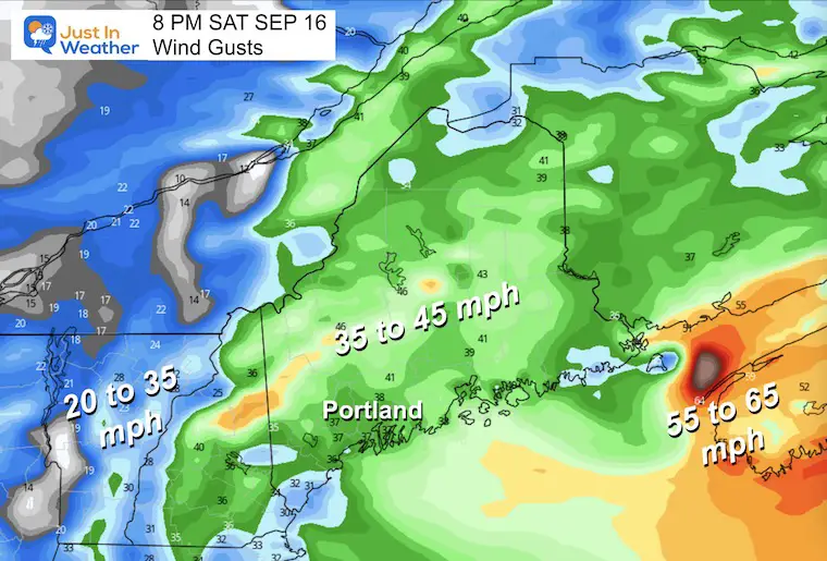
These are the peak winds that may reach 45 mph, especially on the north-facing mountain tops.
The Gulf of Maine will get waves between 10 and 20 Ft, with the larger waves to the east of the center of Lee in Nova Scotia.
Farther down the coast, 6 to 10-foot waves may still be sloshing from Nantucket to Ocean City.
From Dave McHugh: Tidal Swings in the Bay of Fundy (between Maine and Nova Scotia Canada) can be 25 ft on a normal day, up to 50 Ft farther up the Bay. If this arrives at High Tide, the water back up can be devastating.
I will have a follow-up and recap on our amazing week shortly.

Sign up and be the first to know!

I am aware there are some spelling and grammar typos and occasional other glitches. I take responsibility for my mistakes and even the computer glitches I may miss. I have made a few public statements over the years, but if you are new here, you may have missed it: I have dyslexia and found out during my second year at Cornell University. It didn’t stop me from getting my meteorology degree and being the first to get the AMS CBM in the Baltimore/Washington region. One of my professors told me that I had made it that far without knowing and to not let it be a crutch going forward. That was Mark Wysocki, and he was absolutely correct! I do miss my mistakes in my own proofreading. The autocorrect spell check on my computer sometimes does an injustice to make it worse. I also can make mistakes in forecasting. No one is perfect at predicting the future. All of the maps and information are accurate. The ‘wordy’ stuff can get sticky. There has been no editor who can check my work when I need it and have it ready to send out in a newsworthy timeline. Barbara Werner is a member of the web team that helps me maintain this site. She has taken it upon herself to edit typos when she is available. That could be AFTER you read this. I accept this and perhaps proves what you read is really from me… It’s part of my charm.
#FITF