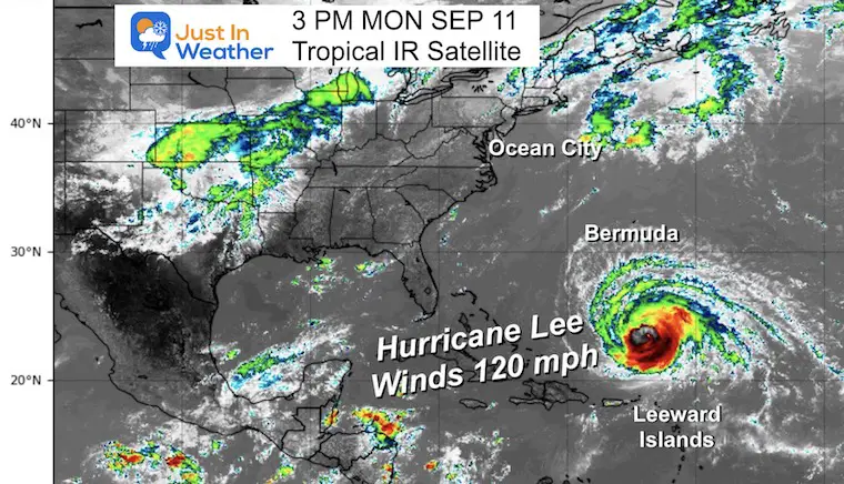
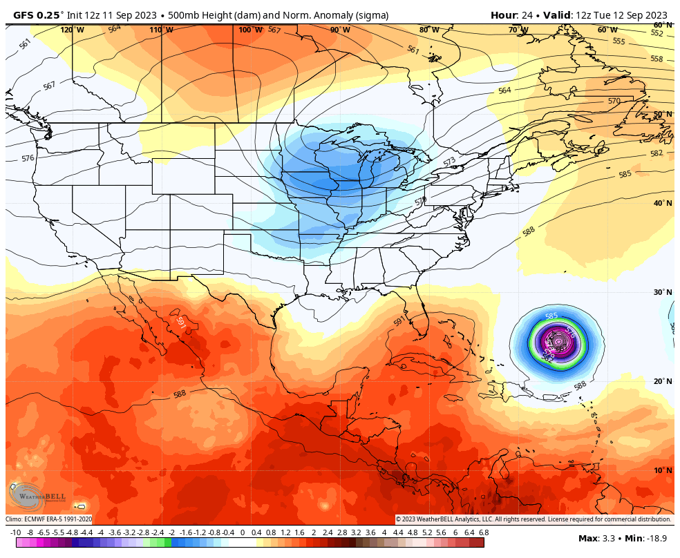
September 11, Monday Afternoon Update
The wild mood swings of Hurricane Lee ramped it up to Category 5 in record time, then knocked it down to Category 2 almost as quickly. Since then, the storm has moved away from wind shear and has restrengthened to Category 3. Winds are currently at 120 mph.
The storm missed the Leeward Islands and is now 600 miles south of Bermuda.
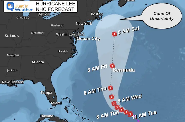
The risk to our Mid-Atlantic region of the US coast is only for rip currents and coastal flooding. The concern now is the adjusted forecast track this weekend which is very close to New England. We will compare the models below.
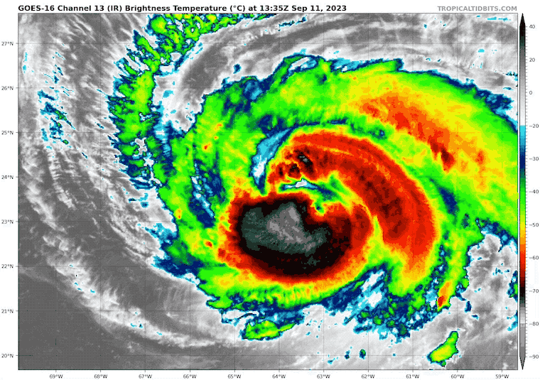
Hurricane Lee Satellite Loop
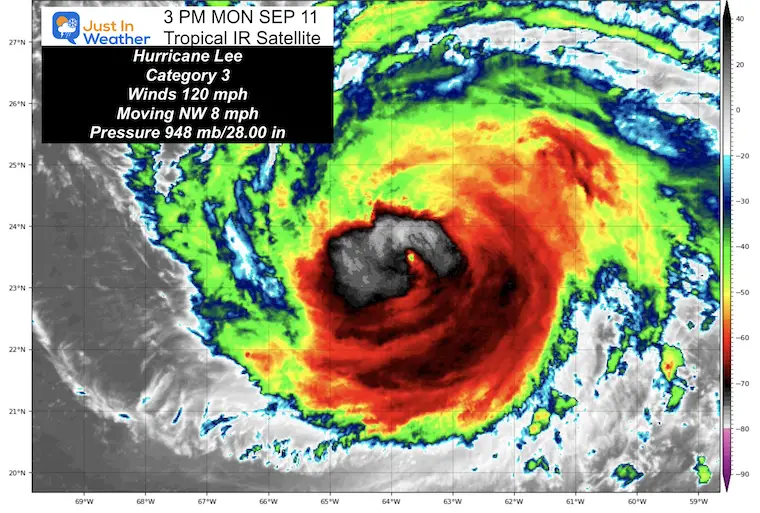
We now are looking at a Category 3 Hurricane with winds of 120 mph.
- Hurricane Force Winds reach 75 miles from the center.
- Tropical Storm Force Winds reach 185 miles from the center.
11 AM update From The National Hurricane Center
- LOCATION…23.5N 63.5W
- ABOUT 365 MI…590 KM N OF THE NORTHERN LEEWARD ISLANDS
- ABOUT 615 MI…985 KM S OF BERMUDA
- MAXIMUM SUSTAINED WINDS…120 MPH…195 KM/H
- PRESENT MOVEMENT…NW OR 310 DEGREES AT 8 MPH…13 KM/H
- MINIMUM CENTRAL PRESSURE…948 MB…28.00 INCHES
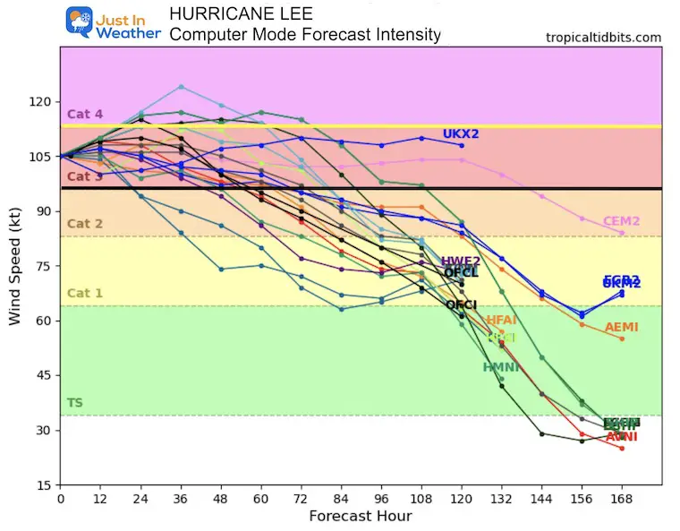
Computer Model Forecast Intensity
The expectation is that it will briefly ramp up to a Category 4, then down again as Hurricane Lee travels over cooler water.
Forecast Tracks: National Hurricane Center
Traveling North, this is going to cross cooler water, some stirred up by prior tracks of Franklin and Idalia.
It will be down to a Category 1 when passing west of Bermuda and racing north close to eastern New England this weekend.
Note: The wide Cone Of Uncertainty.
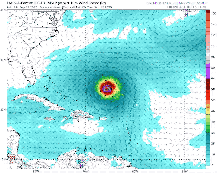
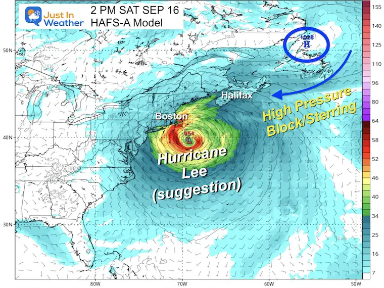
HAFS-A Model Forecast
Tuesday Morning To Saturday Afternoon
This is the 126 Hour Forecast showing it heading to a location south of Cape Cod.
2 PM Saturday Snapshot
This is the end point of this model plot. It is 5 days away and at the edge of marginal reliability. High Pressure in Eastern Canada is expected to reach a position that may steer Lee closer to the New England coast.
The timing of this weather system AND the forward moment of Lee are the wild cards to see how they truly will interact.
I will explore beyond this but with a very cautious perspective.
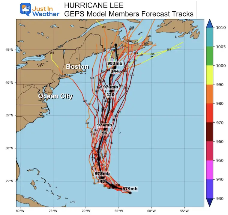
Longer Range Guidance GEPS Member Spread
This model is still suggesting a trend into Nova Scotia, Canada.
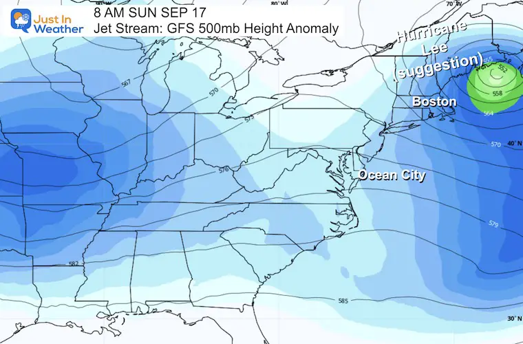
Forecast Animation: Jet Stream GFS Model
Tuesday Morning To Sunday Morning
The adjustment with this storm is in relation to two factors:
The forward speed of Hurricane Lee has slowed down, so it will arrive later.
The cool pattern/trough we expect to protect is here in the Mid Atlantic…. It will then pass by and allow Lee to sneak in after… getting pushed even closer to the coast.
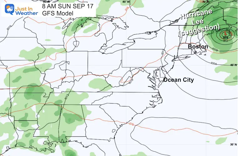
8 AM Sunday Snapshot
The GFS is suggesting the core of Lee will be just to the Southeast of Bangor, Maine. Still not making landfall but dangerously close.
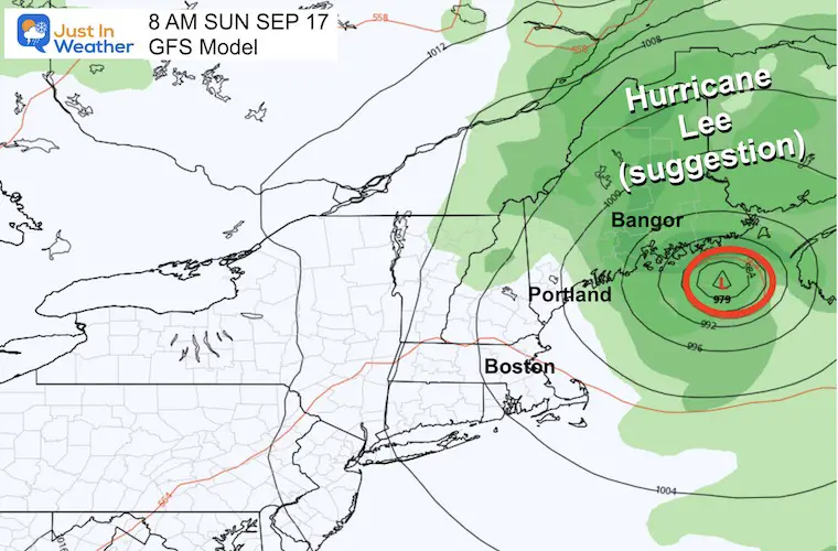
8 AM Sunday Snapshot: Surface Weather
This may help give a perspective of the decaying storm and tight rainfall impact.
8 AM Close Up: New England
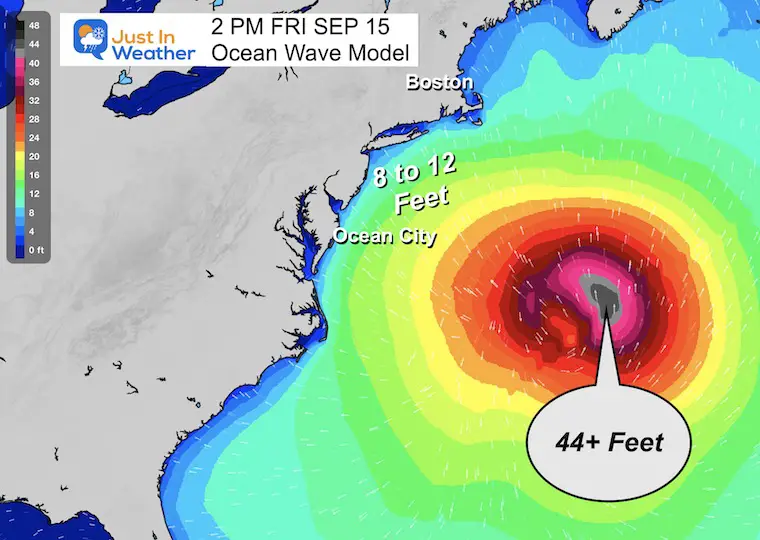
Wave Model Forecast
Friday Afternoon
This may be the closest pass to the Mid-Atlantic. Hurricane Lee should be down to a Category 1 at this time and at least 500 miles or more off the coast.
Peak waves maybe 8 to 12 Feet high, and there could be some concern about tidal flooding.
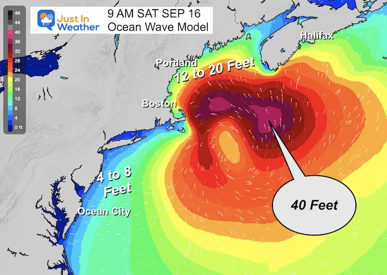
Saturday Morning
This is the question about New England. This model is playing off the GFS Global Guidance. So, the location puts this close to Cape Cod.
The Gulf of Maine may have 12 to 20-foot waves.
The Mid-Atlantic waves may still be 8 to 12 Feet high and behave like a strong Nor’easter.
Atmospheric Memory: This is projected to reach the same region that both Major Hurricane Franklin AND Hurricane Idalia also traversed. This will be something to watch through the Fall and into Winter for any further weather patterns that may result.
EXPLORE MORE
EARLIER IN AUGUST: Maryland Trek 10 For These Kids
I will have a follow-up and recap on our amazing week shortly.

Subscribe for eMail Alerts

Please share your thoughts and best weather pics/videos, or just keep in touch via social media
RESTATING MY MESSAGE ABOUT DYSLEXIA
I am aware there are some spelling and grammar typos and occasional other glitches. I take responsibility for my mistakes and even the computer glitches I may miss. I have made a few public statements over the years, but if you are new here, you may have missed it: I have dyslexia and found out during my second year at Cornell University. It didn’t stop me from getting my meteorology degree and being the first to get the AMS CBM in the Baltimore/Washington region. One of my professors told me that I had made it that far without knowing and to not let it be a crutch going forward. That was Mark Wysocki, and he was absolutely correct! I do miss my mistakes in my own proofreading. The autocorrect spell check on my computer sometimes does an injustice to make it worse. I also can make mistakes in forecasting. No one is perfect at predicting the future. All of the maps and information are accurate. The ‘wordy’ stuff can get sticky. There has been no editor who can check my work when I need it and have it ready to send out in a newsworthy timeline. Barbara Werner is a member of the web team that helps me maintain this site. She has taken it upon herself to edit typos when she is available. That could be AFTER you read this. I accept this and perhaps proves what you read is really from me… It’s part of my charm.
#FITF


