


May 7 Warming Up With Only Isolated Showers And Thunderstorms
Tuesday, May 7 Morning Report We are entering a period of warming with less rain for a few days. We will still see some isolated showers and thunderstorms pop up…
September 5, 2023
Tuesday Morning Update
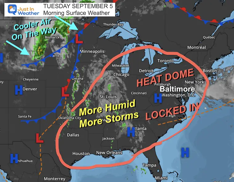
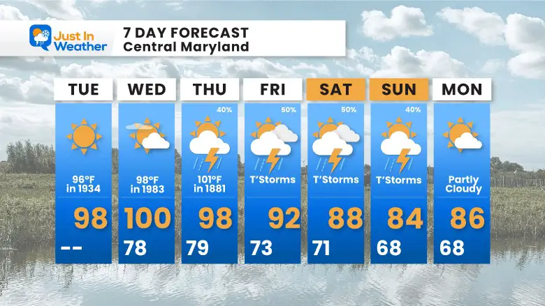
The unofficial end of summer has passed but it still feels like we’re in the thick of it! We continue our record heat wave, but today is different with many returning to school and work. It will challenge the air conditioning for sure! There are at least 2 more days that could set new records.
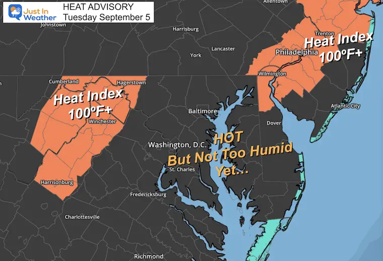
Some Heat Advisories are showing up, where slightly higher humidity will push Heat index values to 100ºF or higher.
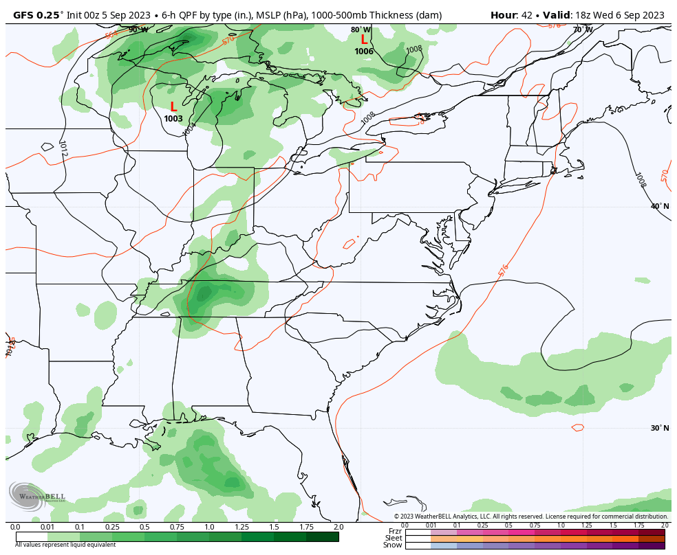
This pattern will break with showers and thunderstorms expanding by Thursday and Friday.
Another record high was broken for Baltimore yesterday. We have a chance to tie or break new records through Wednesday. That would make 4 days in a row, matching a record September heat wave in 1970.
(Sun) Sept 3 = 97ºF in 1898 – Broken with 1 minute at 98ºF
(Mon) Sept 4 = 96ºF in 2019+; BROKEN with 99ºF
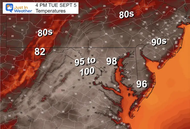
(Tue) Sept 5 = 96ºF in 1954
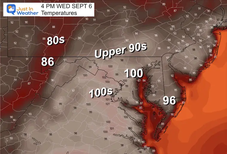
(Wed) Sept 6 = 98ºF in 1983
——Expected Cooling This Week——
(Thu) Sept 7 = 101ºF in 1881 *Hottest September day for Baltimore
(Fri) Sept 8 = 100ºF in 1939
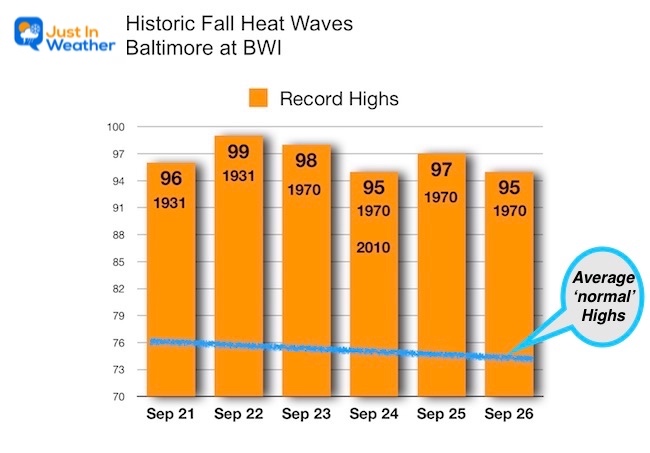
Before the sensationalism you may hear this week, a long-duration record heat wave has happened before.
Here are the late September records for Baltimore. In 1931, there were two records for the 21st and 22nd, which were the 3rd records for that year/month.
1970: September 23 to 26 had 4 days with record highs. The 24th was tied in 2010 and may be the one that shows up on some apps/news reports.
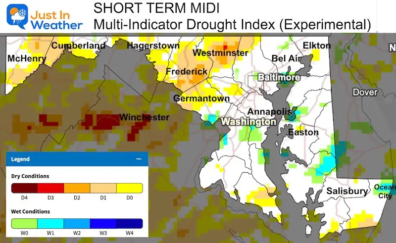
High Pressure remains in control, but with the high heat, we do have relatively low humidity. That is why we have not seen any heat advisories in place.
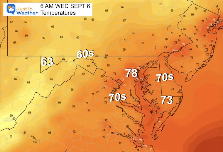
We do see the influence of upper level winds carrying clouds at higher levels from the North. This may limit the early day heating, but expect the sun to return this afternoon.
The alerts have been issued for the mountains and around metro Philadelphia where slightly higher humidity will push Heat Index values over 100ºF. While temps will be in the upper 90s, the humidity has remained lower in central areas…. Like the ‘dry heat’ famed for desert areas.
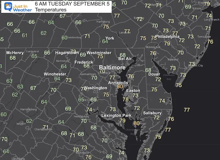
Here comes the heat! The record high in Baltimore was 96ºF in 1954. We are likely to break that at BWI today.
Sunrise at 6:39 AM
Sunset at 7:31 PM
Normal Low in Baltimore: 62ºF
Record 47ºF in 1997
Normal High in Baltimore: 83ºF
Record 96ºF 1954
Click the image to see the full report, including Maryland, Pennsylvania, Virginia, and West Virginia.
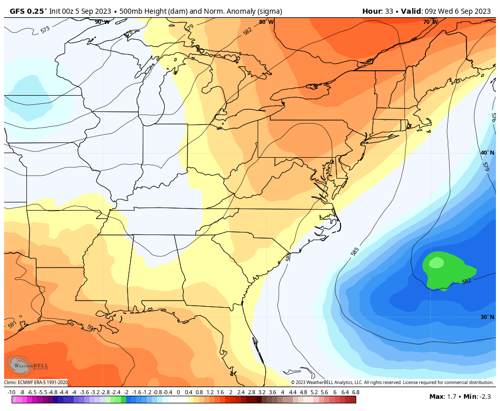
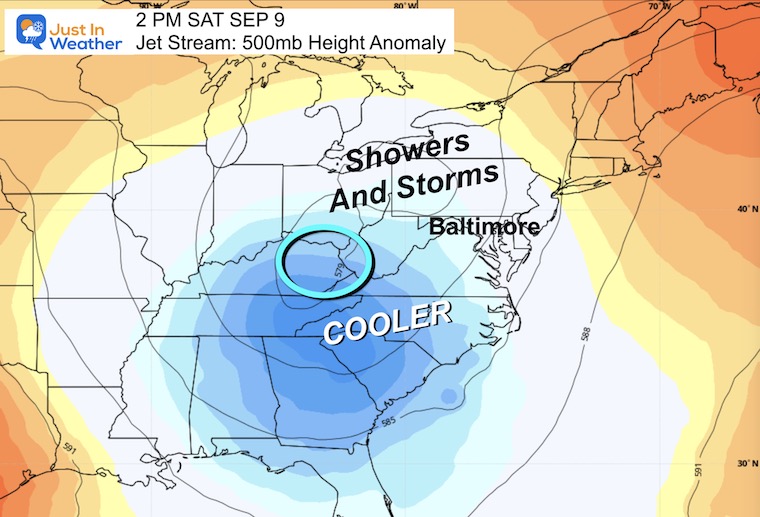
We will gradually see the breakdown of the High Pressure and dry air. Showers will show up in the mountains first on Wednesday, then closer to metro areas Thursday afternoon.
Then we will have a higher chance for thunderstorms on Friday and Saturday as cooler, more seasonable air returns.
We have a chance to tie or break a record high through tomorrow. That would make 4 days in a row and match the 1970 record heat wave stretch.
Temps will back down with more clouds and rain beginning on Thursday. Note that strong or severe storms may be possible to take this energy out of the air.
I will have a follow-up and recap on our amazing week shortly.


I am aware there are some spelling and grammar typos and occasional other glitches. I take responsibility for my mistakes and even the computer glitches I may miss. I have made a few public statements over the years, but if you are new here, you may have missed it: I have dyslexia and found out during my second year at Cornell University. It didn’t stop me from getting my meteorology degree and being the first to get the AMS CBM in the Baltimore/Washington region. One of my professors told me that I had made it that far without knowing and to not let it be a crutch going forward. That was Mark Wysocki, and he was absolutely correct! I do miss my mistakes in my own proofreading. The autocorrect spell check on my computer sometimes does an injustice to make it worse. I also can make mistakes in forecasting. No one is perfect at predicting the future. All of the maps and information are accurate. The ‘wordy’ stuff can get sticky. There has been no editor who can check my work when I need it and have it ready to send out in a newsworthy timeline. Barbara Werner is a member of the web team that helps me maintain this site. She has taken it upon herself to edit typos when she is available. That could be AFTER you read this. I accept this and perhaps proves what you read is really from me… It’s part of my charm.
#FITF