April 29, 2023
Saturday Morning Update
The first storm overachieved and our pattern is following this theme I set up: Overcorrecting! Baltimore was one of many locations that received a daily record rainfall on Friday. While cloudy and cool today, we get a break before the next round of rain on Sunday. What will follow will be a persistent chilly pattern with more storms. This includes very chilly air and mountain snow on Tuesday.
Record Rain Denting The Drought
Baltimore’s BWI received 1.82 inches of rain, a new record for the date April 28.
This more than doubled the rainfall for the month… and is now above normal for April. Still below on the year.
- April = +0.62 inches
- Since March 1 = -1.90 inches
- Since January 1 = -4.02 inches
Outdoor Notes:
If your kids play sports or you have other plans, the ground is soggy! How wet will be site specific depending on local drainage. So I can’t tell if you will ‘play’, but be prepared for some possible hindrance or work needed on some fields.
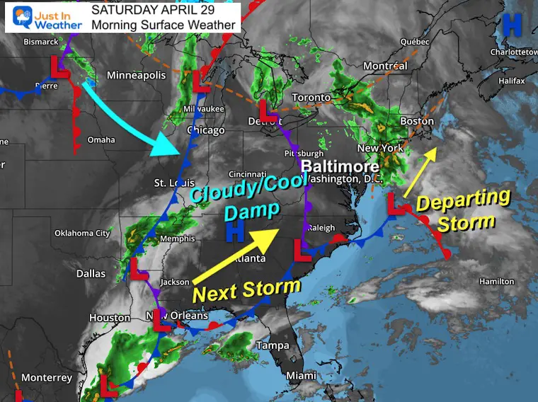
Morning Surface Weather
The first storm is departing and the good news is that the radar looks mostly dry. We cannot rule out leftover drizzle or even showers this morning into northeastern Maryland (Harford/Cecil/Kent Counties).
While mostly cloudy, some breaks of sun are possible this afternoon between weather systems.
The next storm is organizing near the Gulf Coast and will head northeast up the coast for us on Sunday.
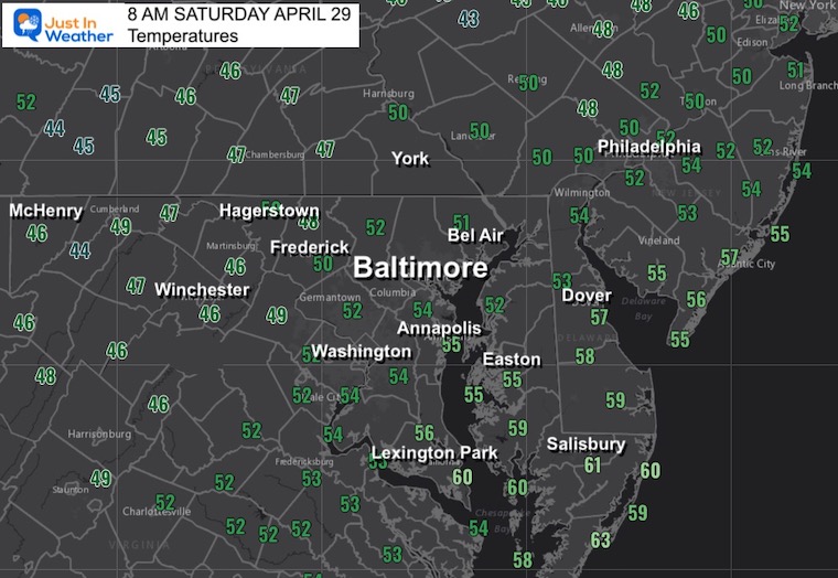
Morning Temperatures
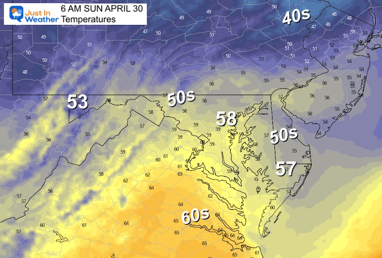
A chilly and damp start to the day.
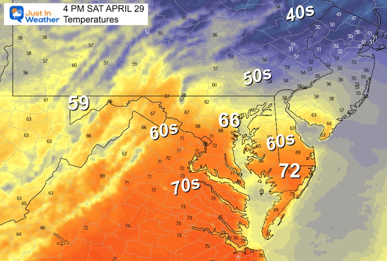
Afternoon Temperatures
A boost back to the 60s will depend on sunny breaks. Most of the morning will be cloudy with pockets of drizzle or fog. The clouds will try to lift and break up this afternoon.
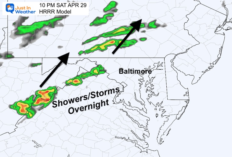
Evening Snapshot
Some bands of rain or thunderstorms will try to develop in the mountains this evening. They will expand overnight.
Subscribe for eMail Alerts
CLIMATE DATA
TODAY April 29
Normal Low in Baltimore: 48ºF
Record 32ºF in 2022 – Record Set Last Year
Normal High in Baltimore: 71ºF
Record 90ºF 1957
REPORTS:
NEW:

Sunday Morning Temperatures
Another chilly start, with temperatures remaining nearly steady in central Maryland all day.
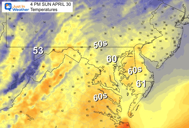
Afternoon Temperatures
Temps will be steady or falling slightly through the lower 50s with the rain. These numbers will be 15 to 20 degrees BELOW AVERAGE and more like early March.
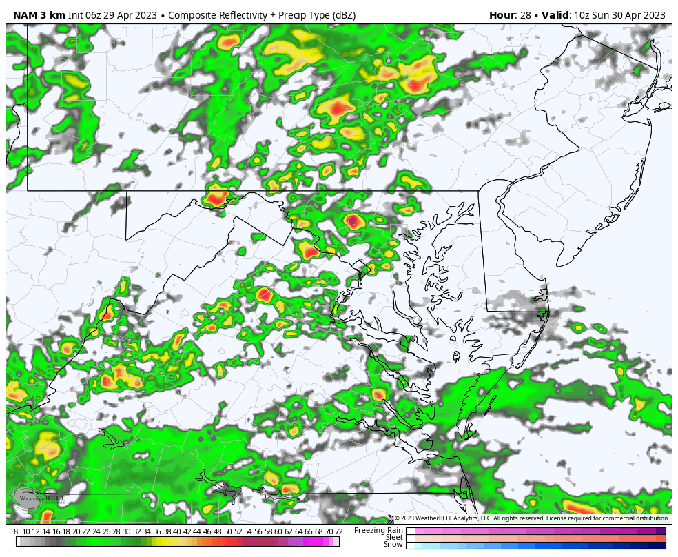
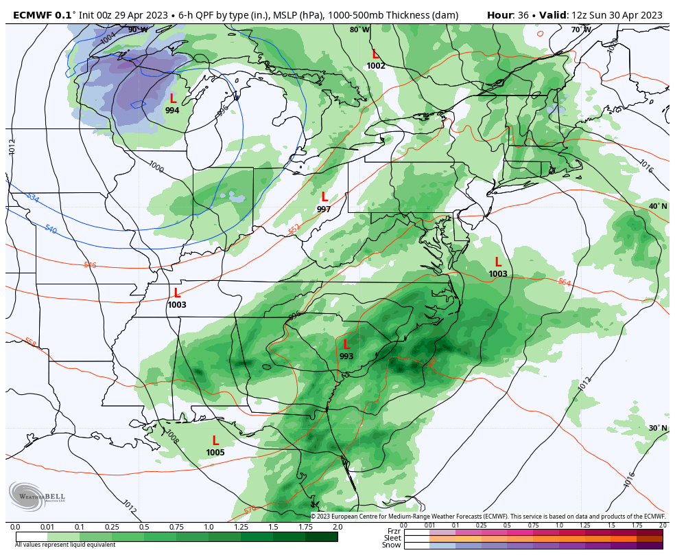
Sunday Radar Simulation
6 AM to 10 PM
Rain will be with us in the morning and last throughout the day. It may become spotty, which will also include some thunderstorm cells.
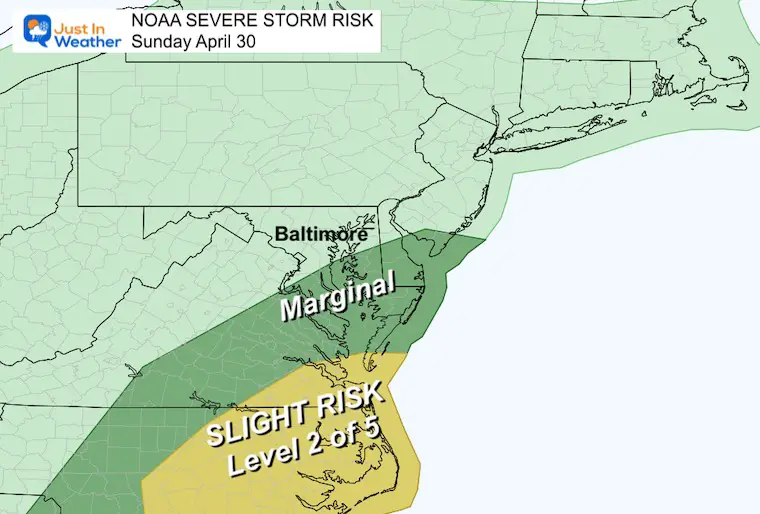
Sunday Storm Risk
NOAA Outlook
I should point out that we have a trend for these zones to shift north on the day of …
For now: Southern Maryland and Delmarva are painted in the ‘Marginal’ Risk. This means there may be thunderstorms and one or two could reach severe limits with wind/hail damage
The Slight Risk means there is a better chance for Southeast Virginia to eastern North Carolina.
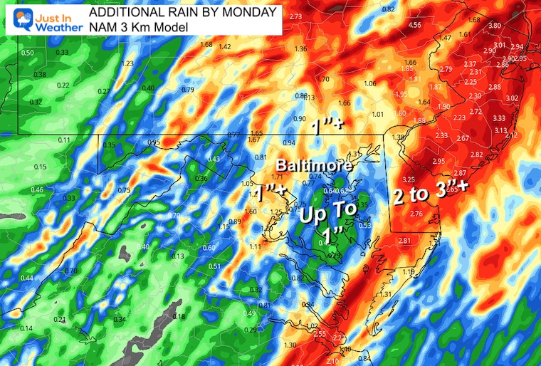
Additional Rain Forecast
With Low Pressure forecast to ride along the I-95 corridor, the heavier rain is more likely to the East and also West in the Mountains.
Many will see more than 1 inch of rain. Some places could exceed over 2 more inches, but around the Chesapeake Bay under 1 inch is expected.
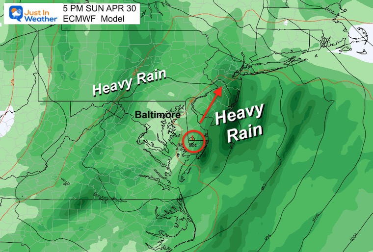
Snapshot Sunday Late Afternoon
Periods of rain will be with us through the day. Low Pressure is likely to pass through Maryland later in the day.
Forecast Animation Saturday To Tuesday
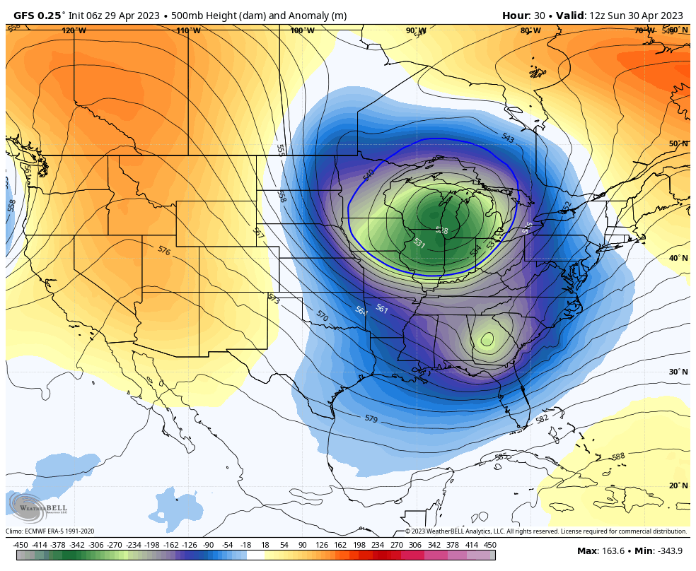
The Sunday storm is rotating around a larger Upper Level Low in the Great Lakes. The net result will swing that storm through, then follow with unsettled weather and showers into mid-week. This also includes snow in the mountains.
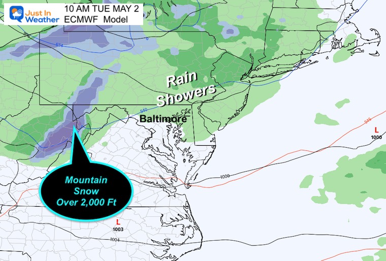
Tuesday
The following weather system will tap into that core of colder air. The net result will bring us more rain AND higher elevation snow. This may produce some accumulation for Garrett County Maryland and the high ridge in West Virginia.
Jet Stream Snapshot Wednesday
The core of the cold air with the upper air pattern will reach the east coast.
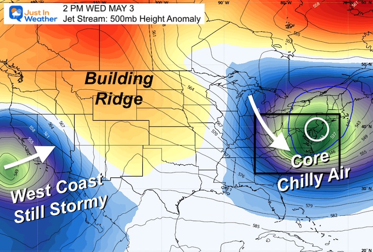
Jet Stream Sun Apr 30 to Sun May 7
If this was winter, we would be talking about snow. But in May the reinforcement of cooler air will come with unsettled rain showers and perhaps another storm.
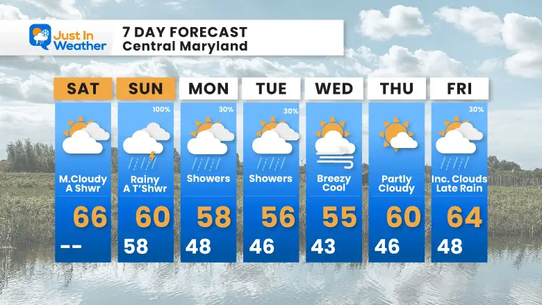
7 Day Forecast
This outlook would be more appropriate for mid to late March rather than early May. The cool pattern will have our afternoon temperatures 10 to 15 degrees cooler than average. It looks like mid week showers, then another storm possible for yet another weekend just out of reach.
STEM Assemblies/In School Fields Trips Are Back
Click to see more and ‘Book’ a visit to your school

Please share your thoughts, best weather pics/videos, or just keep in touch via social media
RESTATING MY MESSAGE ABOUT DYSLEXIA
I am aware there are some spelling and grammar typos, and occasional other glitches. I take responsibility for my mistakes, and even the computer glitches I may miss. I have made a few public statements over the years, but if you are new here you may have missed it: I have dyslexia, and found out during my second year at Cornell University. It didn’t stop me from getting my meteorology degree, and being first to get the AMS CBM in the Baltimore/Washington region. One of my professors told me that I had made it that far without knowing, and to not let it be a crutch going forward. That was Mark Wysocki and he was absolutely correct! I do miss my mistakes in my own proofreading. The autocorrect spell check on my computer sometimes does an injustice to make it worse. I also can make mistakes in forecasting. No one is perfect predicting the future. All of the maps and information are accurate. The ‘wordy’ stuff can get sticky. There has been no editor that can check my work when I needed it and have it ready to send out in a newsworthy timeline. Barbara Werner is a member of the web team that helps me maintain this site. She has taken it upon herself to edit typos, when she is able. That could be AFTER you read this. I accept this and perhaps proves what you read is really from me… It’s part of my charm.
#FITF
Subscribe for eMail Alerts


