


May 17 Clouding Up Ahead Of A Soggy Preakness Saturday Then We Warm Up
Friday May 17 Morning Report Today may end up mild, but it will bring an increase in clouds ahead of our next storm. If you are heading to the mountains,…
April 29, 2023
Saturday Afternoon Update
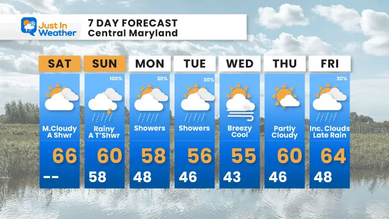
The second in our planned double weekend of storms is set to be here by the time we wake up on Sunday morning. This has a little more complication to it, as there will be a warm sector and a track for potential thunderstorms. It will impact our southern and eastern areas with more rain and perhaps severe storms as well.
The chilly air that follows will be cold enough for accumulating snow in the high mountains of western Maryland and West Virginia while bringing chilly rain showers for central areas mid week.
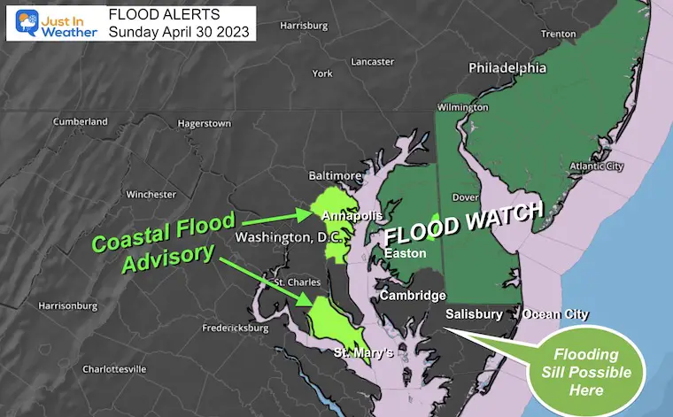
With the expectation, NOAA has posted a Slight Risk for severe storms AND a Flood Watch. I will start with those maps, then get to the forecast simulations.
Please note that while Southern Maryland is not in the ‘Watch’ they may be added later given the models I am seeing. The discretion is up to the local NWS office out of Wakefield, VA.
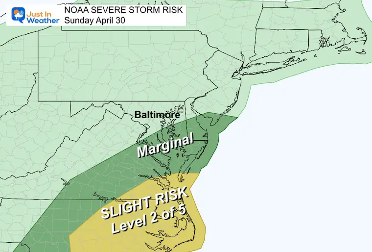
The Slight Risk area is farther south, with a possibility of a few storms turning severe. The Marginal Area may have thunderstorms with perhaps an isolated one or two producing strong enough winds or hail.
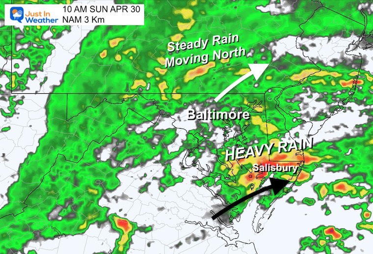
The rain will be returning by morning. There will be an initial surge, then the actual Low Pressure arrives later in the afternoon and evening.
A morning rain may break to showers, then thunderstorms that have the chance to turn severe… This is more likely in Southern Maryland, Lower Delmarva, and Southeast Virginia.
Rain will be with us before sunrise. While the initial rain may push north with a lull in central Maryland, the first heavy rain band will surge across The Lower Eastern Shore.
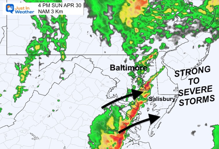
A line of strong to severe storms may form along and east of the front, where temps may reach close to 70ºF.
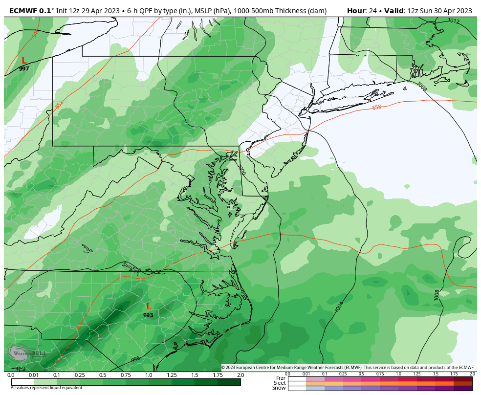
The ECMWF Model continues to plot the Low Pressure riding close to the Chesapeake Bay.
Heaviest rain will be in the mountains AND on Delmarva with a few rounds of thunderstorms that may turn strong to severe.
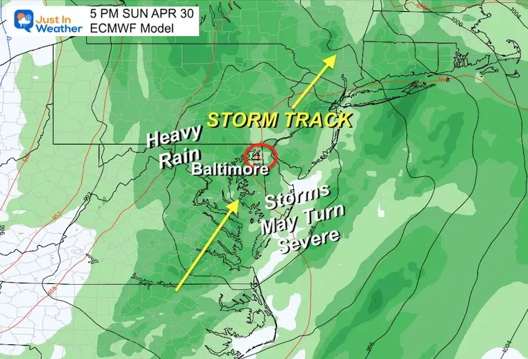
Steady rain in the morning then showers and thunderstorms in the afternoon. We may have to watch for one or two intense lines and potential severe elements.
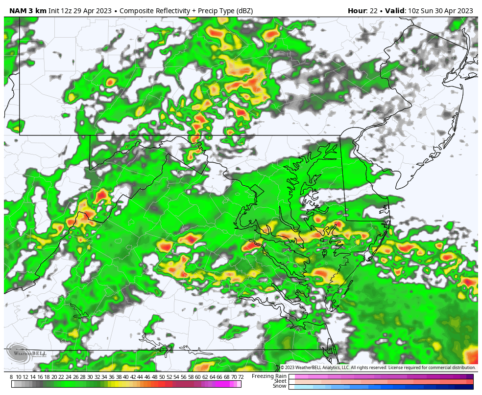
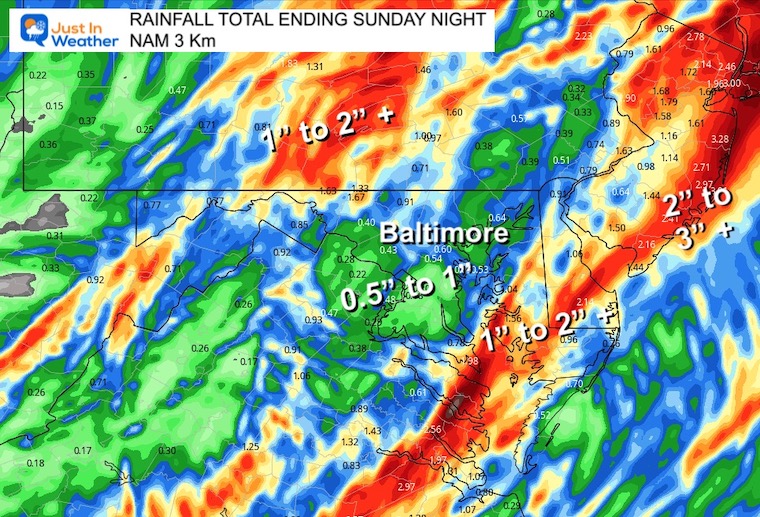
This is the Sunday rain total through midnight from the NAM 3 Km Model. This matches the simulation shown above and highlights the multiple heavy rain bands and possible strong to severe thunderstorms for Southern Maryland and the Eastern Shore.
The other pocket of heavier rain west of Baltimore is the enhancement from the uplift along the mountains.
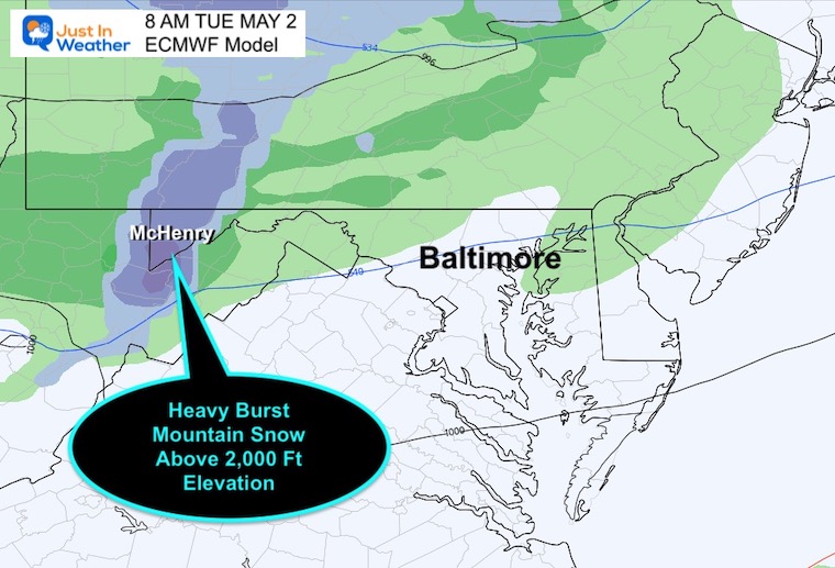
In a true winter pattern fashion, The Great Lakes will open up with the next disturbance Tuesday into Wednesday. While we may see some rain showers again, the high mountains may be in store for a rare May snow. This is more likely above 2,000 Ft elevation which includes Garrett County, MD and parts of West Virginia to Western PA.
I chose this setting to show the storm progress and what will follow. The upper level Low in winter-style will pivot out of the Great Lakes and bring more showers and chill to the air for a few days. This will include snow for the mountains of Western Maryland and West Virginia Monday night through Wednesday.
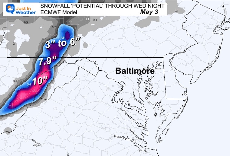
Spring snow favored higher elevations above 2,000 Ft. This does include Garrett County in Maryland. The higher up AND ALSO timing overnight will determine the ability for stickage and how much accumulation.
This is assuming a 10:1 ration and all the snow sticks… Most likely there will be melting and compression. We could safely assume totals may be half of what we see here.
The core of the cold air with the upper air pattern will reach the east coast.
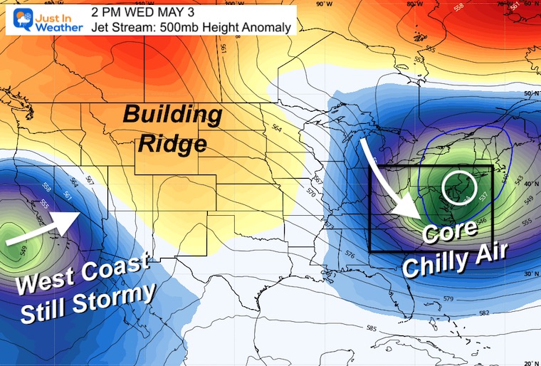
If this was winter, we would be talking about snow. But in May the reinforcement of cooler air will come with unsettled rain showers and perhaps another storm.
This outlook would be more appropriate for mid to late March rather than early May. The cool pattern will have our afternoon temperatures 10 to 15 degrees cooler than average. It looks like mid week showers, then another storm possible for yet another weekend just out of reach.
Click to see more and ‘Book’ a visit to your school

I am aware there are some spelling and grammar typos, and occasional other glitches. I take responsibility for my mistakes, and even the computer glitches I may miss. I have made a few public statements over the years, but if you are new here you may have missed it: I have dyslexia, and found out during my second year at Cornell University. It didn’t stop me from getting my meteorology degree, and being first to get the AMS CBM in the Baltimore/Washington region. One of my professors told me that I had made it that far without knowing, and to not let it be a crutch going forward. That was Mark Wysocki and he was absolutely correct! I do miss my mistakes in my own proofreading. The autocorrect spell check on my computer sometimes does an injustice to make it worse. I also can make mistakes in forecasting. No one is perfect predicting the future. All of the maps and information are accurate. The ‘wordy’ stuff can get sticky. There has been no editor that can check my work when I needed it and have it ready to send out in a newsworthy timeline. Barbara Werner is a member of the web team that helps me maintain this site. She has taken it upon herself to edit typos, when she is able. That could be AFTER you read this. I accept this and perhaps proves what you read is really from me… It’s part of my charm.
#FITF
