


May 17 Clouding Up Ahead Of A Soggy Preakness Saturday Then We Warm Up
Friday May 17 Morning Report Today may end up mild, but it will bring an increase in clouds ahead of our next storm. If you are heading to the mountains,…
April 27, 2023
Thursday Evening Update
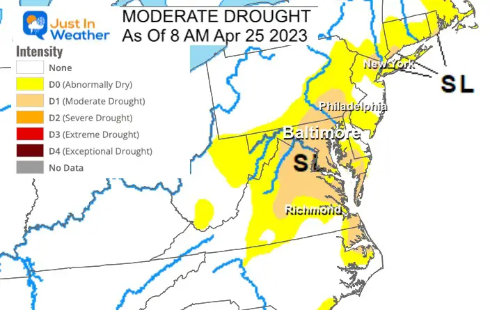
I think the best way to describe this new weather pattern is an overcorrection. After one of the warmest winters with the lowest snow, we are also lacking in total precipitation. Combine that with two record high temperatures this month and net result as we roll deep into the growing season has been a building drought.
The best way to end a drought is a steady long duration rain. We do not want it all at once, but may get it all, twice. Both Friday and Sunday.
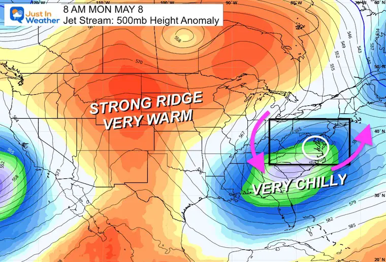
The other counterbalance to the heat will come with a persistent chilly pattern for the next 10 days. Temperatures may run 15 to 20 degrees below average. It will bring even more storms and perhaps an accumulating snow for the high mountains of western Maryland and West Virginia next week.
As of this week, Maryland (for example in the middle of my coverage region) has been identified with a Moderate Drought. Using the Baltimore weather station as reference, here are the rainfall deficits:
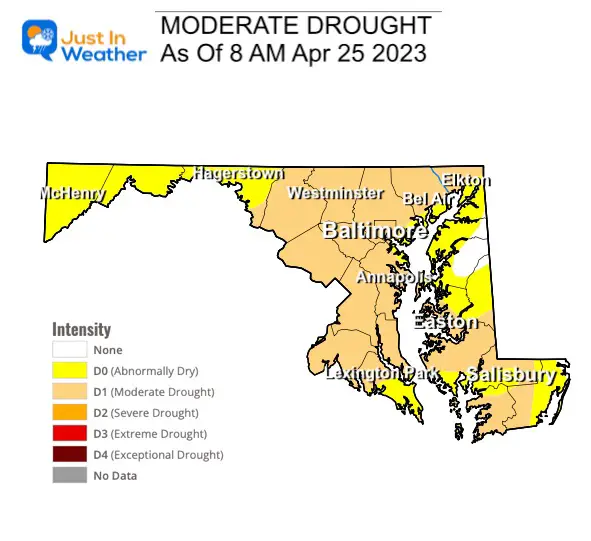
Note: The deficit since January is more important to river levels and the water table. However, the deficit since March 1 is more prominent affecting crops. This 3 inch range is within reach of recovery this weekend.
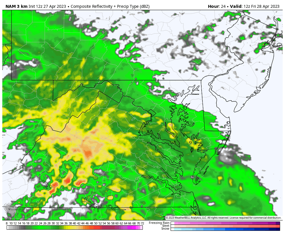
One thing I’ve seen consistently is that weather systems appear to speed up, or the modeling is too slow and plays catch up. At this point, it looks like rain will be overspreading into central Maryland around sunrise, then last all day.
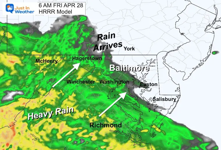
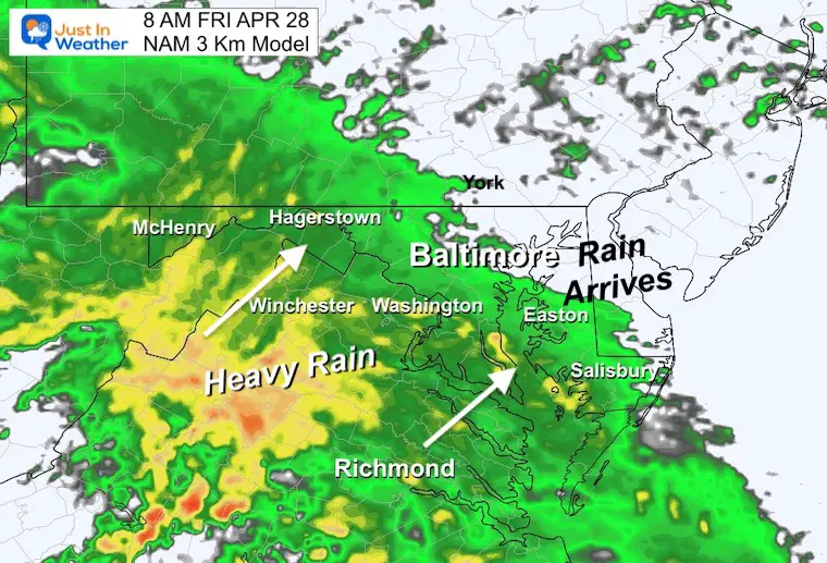
Steady rain moves in for most of us throughout the day. Pockets of heavier rain will move in from the south.
While there is a tendency for storms to arrive and depart earlier than shown here, it’s safe to call this a wet day and evening. The rain will end overnight….
A wide range of 1 to 2+ inches of rain. Close to an inch for Southern PA. Less is expected on Delmarva and slightly more over the mountains.
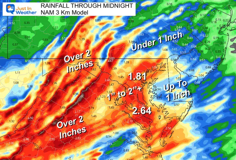
The stronger East Wind will range from 20 to 30 mph. This will help the slosh the water to the Western Shore. So in addition to rainfall, the tides will be running extra high near Annapolis and Bowley’s Quarters in Baltimore County.
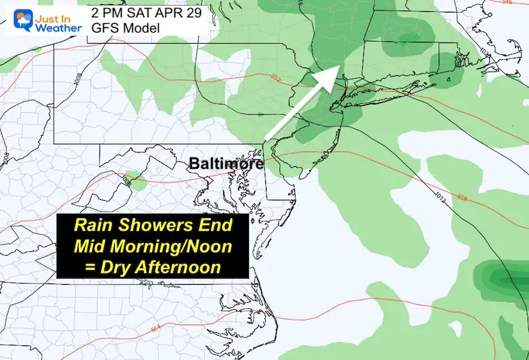
At this point, I would suggest the morning will be damp as the rain will be tapering off to showers and ending. My boy has baseball practice and we are just working around the expectation of a soggy field even when the rain stops.
If you have afternoon plans, most of the region should be dry. That is the time to get out.
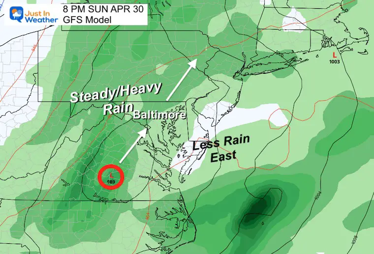
The rain will be returning by morning, then become steadier in the afternoon and evening. I made this snapshot for 8 PM to show the location of the Low Pressure as it will track west of I-95 and pass through our region overnight.
Friday Morning to Monday Morning – GFS Model
Here we can see the sequence of both events.
Note the dry time will be Saturday mid day to evening.
Sunday: The steady rain in the afternoon will continue overnight which is when it will be heaviest. This should move out and be gone by Monday morning.
By Monday morning, it is possible that a large portion of The Mid Atlantic could get over 2 inches of rain. On the high end, some spots could push beyond 4 inches.
Please do NOT take this map at face value. The higher pockets of rain will depend on the individual cells and is subject to change that the models can’t lock in on now.
This is a guide for the region. I would lean on a general 1 to 3 inches of total rain, with some higher spots.
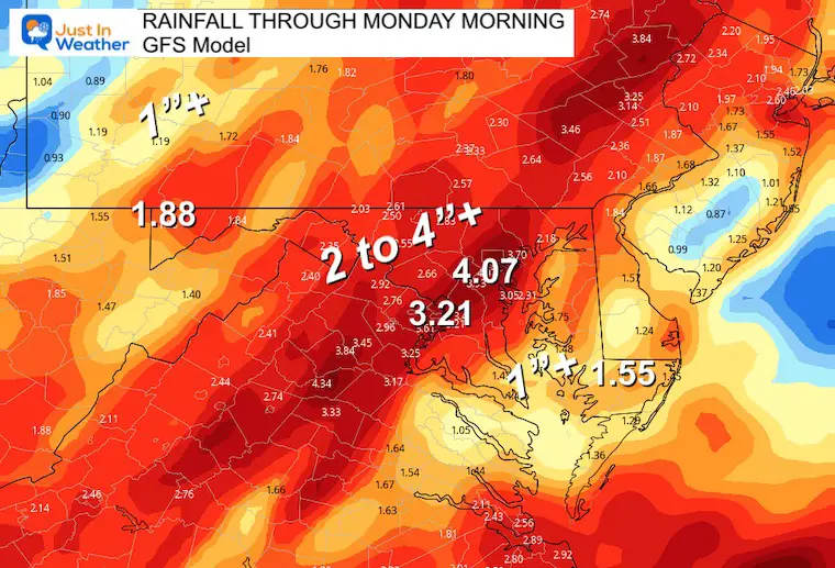
A chance to put a dent into the drought from Virginia to New York.
In a true winter pattern fashion, The Great Lakes will open up with the next disturbance on Tuesday into Wednesday. While we may see some rain showers again, the high mountains may be in store for a rare May snow. This is more likely above 2,000 Ft elevation which includes Garrett County, MD and parts of West Virginia to Western PA.
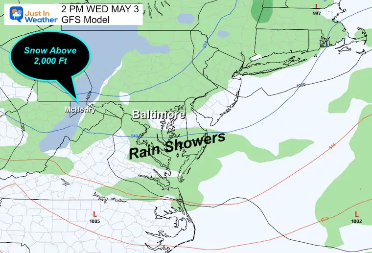
If this was winter we would certainly be talking about multiple snow events. But in May we will just get a deep chill and perhaps another frosty morning inland.
In fact, the set up seen below, if it verifies, could bring a coastal storm next week followed by a dangerous frost to parts of the Southeast US.
If only we had this in winter… Simply the cold getting reinforced.
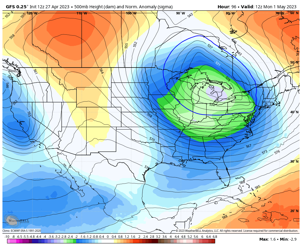
This is a long range outlook, so take it with a grain of salt. But if this is close to verifying, then there could be another weekend coastal storm followed by abnormal cold with danger for frost in the interior section of the Southeast US.

Click to see more and ‘Book’ a visit to your school

I am aware there are some spelling and grammar typos, and occasional other glitches. I take responsibility for my mistakes, and even the computer glitches I may miss. I have made a few public statements over the years, but if you are new here you may have missed it: I have dyslexia, and found out during my second year at Cornell University. It didn’t stop me from getting my meteorology degree, and being first to get the AMS CBM in the Baltimore/Washington region. One of my professors told me that I had made it that far without knowing, and to not let it be a crutch going forward. That was Mark Wysocki and he was absolutely correct! I do miss my mistakes in my own proofreading. The autocorrect spell check on my computer sometimes does an injustice to make it worse. I also can make mistakes in forecasting. No one is perfect predicting the future. All of the maps and information are accurate. The ‘wordy’ stuff can get sticky. There has been no editor that can check my work when I needed it and have it ready to send out in a newsworthy timeline. Barbara Werner is a member of the web team that helps me maintain this site. She has taken it upon herself to edit typos, when she is able. That could be AFTER you read this. I accept this and perhaps proves what you read is really from me… It’s part of my charm.
#FITF