


July 12 Very Humid With Scattered Thunderstorms Later And More Storms Tomorrow
Saturday, July 12, 2025 Morning Report This may sound familiar: We remain in the ambiguous humid air mass. There is thick fog this morning, and the sun will dominate the…
March 12 2023
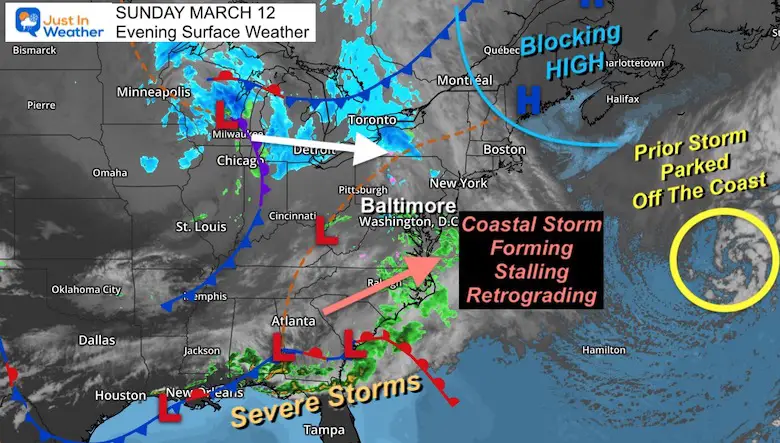
Sunday Evening Update
The largest winter storm of the season for the east coast is about to develop. It is fascinating that this is on the 30th Anniversary of the Superstorm of 1993, but much more complicated. There is a parking lot in the northern Atlantic Ocean that will help this storm organize and get stuck. In fact, the double-barrel Low may do something rare that could push it back west and south.
This storm has the potential to BUST a lot of forecasts across the Northeast. Please note, that could go either lower or higher on the snowfall.
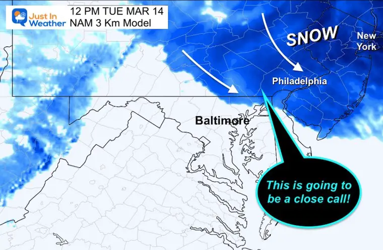
This is NOT a promise, but a concern that our region will be on the edge and could still have some impact. Tuesday may bring the back edge of the storm into metro Philadelphia, and on the maps below we see that Maryland may want to keep watching between northern Baltimore, Harford, and Cecil Counties.
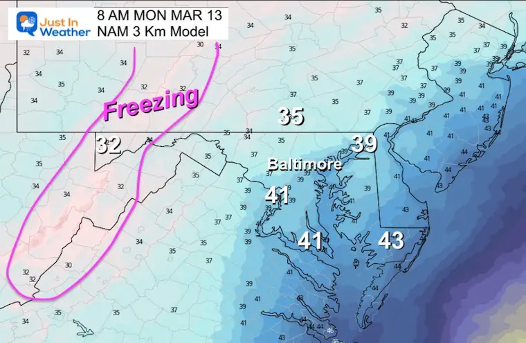
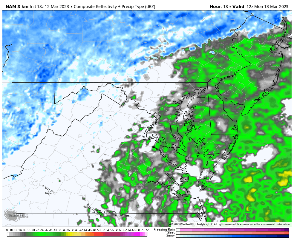
The light snow and rain mix we have seen today is part of the formation of a new coastal Low.
Atlantic Ocean Traffic Jam
Great Lakes
Southeast US
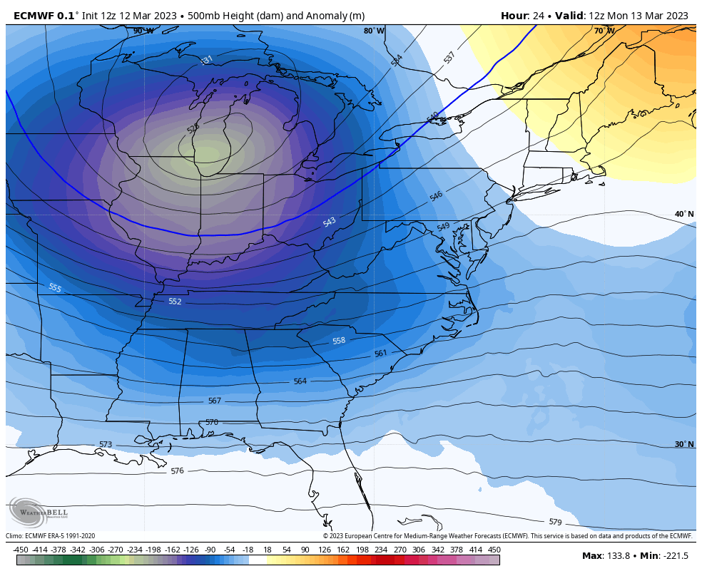
Upper Level Energy will be digging a Deep Trough (blue) across the Eastern US. The center (green) appears to possibly close off from the Jet Stream, which is why it may stall or retrograde the Low near Boston.
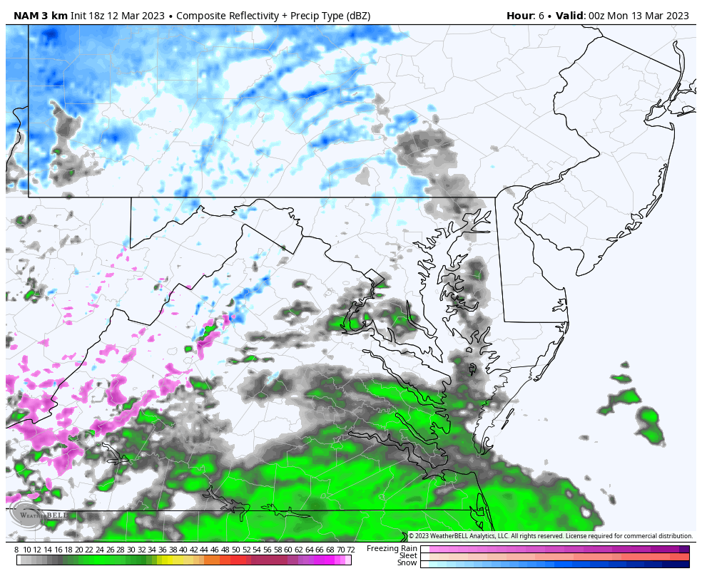
Radar Simulation
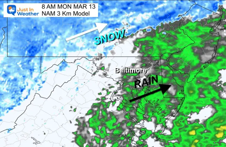
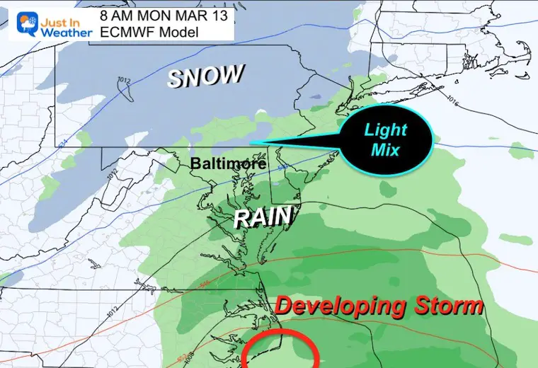
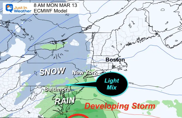
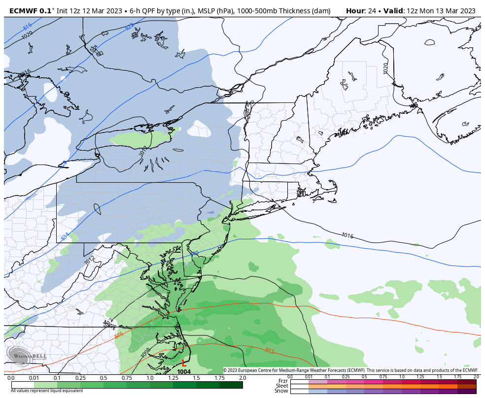
Light precipitation develops overnight to morning. There will be split on the edge of the light snow to the north and steady rain to the south.
The freezing temperatures will be confined to the mountains. So even if there is a mix of snow and rain on the north side, there will not be any impact on the roads.
Low Pressure will be forming along the North Carolina Coast.
Rain may be steady and heavy in southern Maryland closer to the storm center.
Again: If there is a mix in the local northern suburbs, it will fall in temps above freezing.
I just wanted to shift the view to this perspective. Now we can see the development of this complicated storm better.
Low Pressure: Watch the wide turn in the Atlantic, then pull back near Boston. This is in response to the Upper Level closed Low and deep trough.
This storm nearly stalling or retrograding Further back to the West is the big BUST potential.
That 974 mb Low is equivalent to a Category 1 Hurricane. It will be a true wind machine and heavy snow maker.
Steady, heavy snow is likely between Boston and New York, with blizzard conditions!
The back edge of the snow may try to pull back to Northeastern Maryland. Under normal circumstances we do not expect to get much snow from ‘backlash’ precipitation. This is not a favored region for it. However, a retrograding Low is a different story. So any more push west could bring a big change for a lot of people.
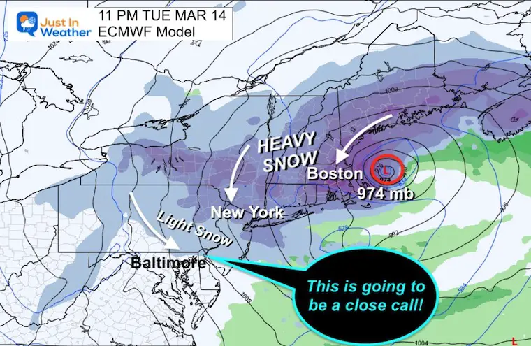
Yes, at first glance it looks like this storm may be a miss for our region. Then watch that band of snow attempt to drop south/southwest.
If this verifies, it could bring some snow to Maryland’s northern Baltimore, Harford, and Cecil Counties. In Pennsylvania we could see York, Lancaster, to Philadelphia in the discussion.
I am only showing the ECMWF Model, but there is a wide range of solutions.
The retrograde on Tuesday will make or break the snow totals for this event. It could sit and stall, it may end up farther west to bring more into the snow zone.
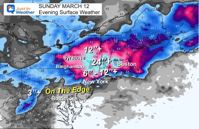
Some areas will get over 2 feet of snow from this storm, but the edges are the worry. We are on the edge and currently that DOES NOT include all of Maryland. However, it is worth keeping a close eye on any developments that could bring us more into the fold.
Sign up and be the first to know!
My REALISTIC Expectations for the COLD OUTLOOK
Winter History: Low Snow And Late Starts
See my research based on Baltimore data since 1883.

I am aware there are some spelling and grammar typos, and occasional other glitches. I take responsibility for my mistakes, and even the computer glitches I may miss.
I have made a few public statements over the years, but if you are new here you may have missed it:
I have dyslexia, and found out during my second year at Cornell University. It didn’t stop me from getting my meteorology degree, and being first to get the AMS CBM in the Baltimore/Washington region. One of my professors told me that I had made it that far without knowing, and to not let it be a crutch going forward. That was Mark Wysocki and he was absolutely correct!
I do miss my mistakes in my own proofreading. The autocorrect spell check on my computer sometimes does an injustice to make it worse. I also can make mistakes in forecasting. No one is perfect predicting the future.
All of the maps and information are accurate. The ‘wordy’ stuff can get sticky.
There has been no editor that can check my work when I needed it and have it ready to send out in a newsworthy timeline. Barbara Werner is a member of the web team that helps me maintain this site. She has taken it upon herself to edit typos, when she is able. That could be AFTER you read this.
I accept this and perhaps proves what you read is really from me…
It’s part of my charm.
#FITF
Click to see more and ‘Book’ a visit to your school

I see many factors to support colder influence with multiple systems. Early and later in winter. Check it out. https://justinweather.com/2022/11/22/winter-outlook-2023-for-snow-not-typical-la-nina-plus-polar-vortex-disruption/
Winter Outlook 2023 Early Look At Snow From Two Farmers Almanacs
https://justinweather.com/2022/09/09/winter-outlook-2023-la-nina-triple-dip-expectations/
If you want a snowy winter, this is what you might want to look for in the rest of the tropical season. https://justinweather.com/2022/08/31/record-august-for-no-named-tropical-storms-closer-look-at-snow-following/
https://justinweather.com/2022/10/25/winter-weather-outlook-from-the-wooly-bear-caterpillar/

