


May 9 Cooler With Rain And Severe Storm Risk Tonight South
Thursday May 9 Morning Report Today is the first day of the year with sunrise before 6 AM in Baltimore, but we won’t see it. After a high temperature of…
February 6, 2023
Monday Evening Update
My fellow winter lovers are hurting as we enter prime time and no snow in sight. Or is there? I took the morning off to go snowboarding at Roundtop in York County, PA. Despite the uncooperative weather, the conditions with ‘made’ snow were pretty good. This may have scratched my itch for a day, but I am still on the search to figure this season out.
I was going to take the evening off, but after seeing snow show up on the European Model for this weekend, I wanted to dig a little deeper. After going down the rabbit hole, I’ve come back with a few things to share with you. They include another attempt at the Polar Vortex later this month, and the end of La Niña may flip to a robust El Niño by this summer.
Most of the terrain was open, and it’s good packed powder.
The initial storm track is once again to the Great Lakes, which is why we expect to pump in the 60s and rain. There is another system that will try to follow with air that is just cold enough on Saturday.
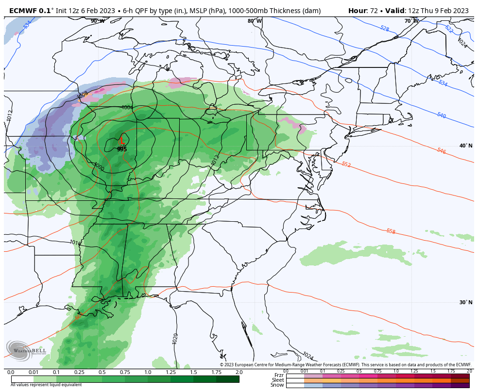
The thing that gets me here is that there has been some form of a winter event showing up for more than 3 days. There is a signal, even if the modeling is having trouble with it.
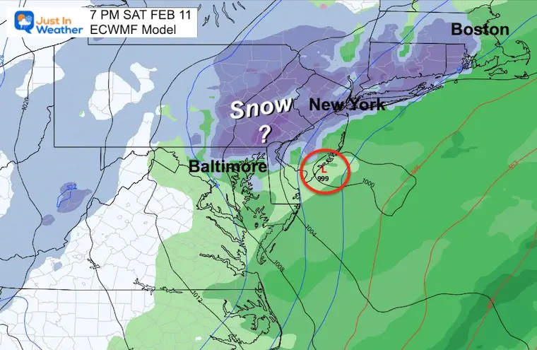
Here we see a developing surface Low pulling in colder air for perhaps our inland areas to get snow.
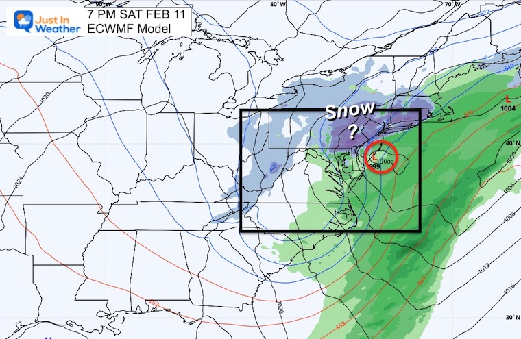
This helps to show the evolution of rain to snow.
From this perspective, it may be a marginal event. I would not hold my breath, but I have plans, and you may as well. I just ask you to keep an open mind as I expect this will continue to evolve. More likely inland and north, less likely south.
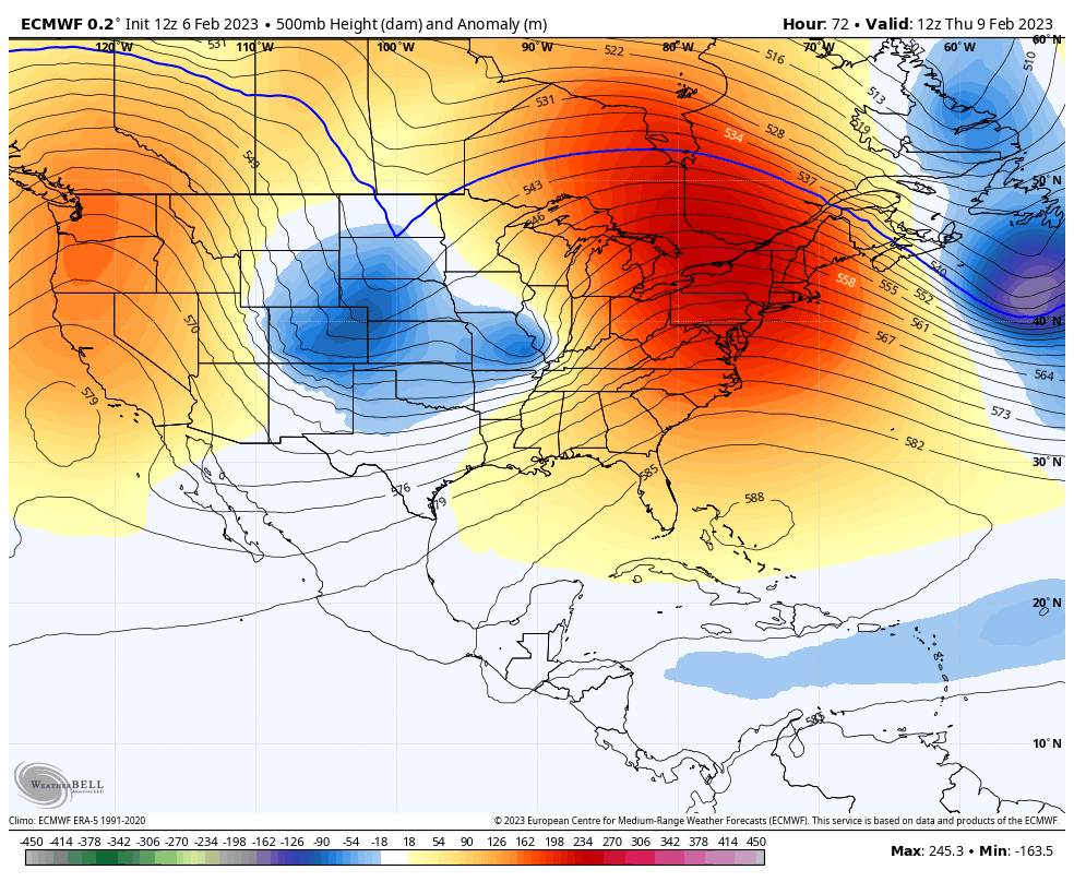
The upper-level support shows a deep trough along the East Coast. This is not the most favorable, but it has been trending that way. The chilly air aloft is what will help drive that event and pull down ‘just cold enough’ air.
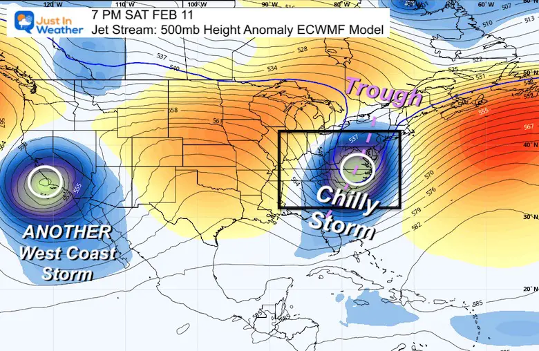
This is a fast-moving pattern, so if we get this hit, it will be another one to two day impact. One ridge (orange) will be replaced by yet another one next week.
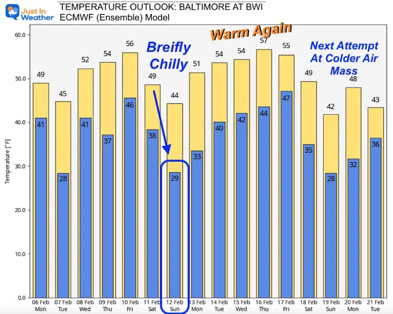
This is the same ECMWF Model with the ensemble product showing that next weekend does NOT look cold enough for snow.
This is one of those confusing setups where it looks like highs in the 40s, which is not cold enough for snow. Your app may be showing rain as well.
Please keep in mind that this is for Baltimore at BWI, and the snow plot shown above may be just north.
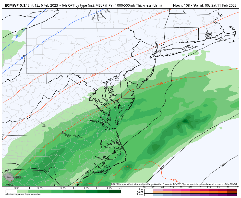
ALSO: The forecast above shows rain in the morning, possibly changing to snow in the evening. The high temperature could be early in the day.
I’ve highlighted the Sunday morning Low of 29ºF.
Farther Out: We warm up again, and it looks like the end of March.
I am sure you are getting tired of hearing about this. That record low wind chill on Mount Washington this past weekend was a direct result of that circulation.
There are upper-level signals showing that it will try again.
This is marked by stratospheric warming. That is in the high level of the atmosphere where the Chinese Balloon was floating (but unrelated, I hope).
Here is a statement from a different source so you don’t just hear it from me:
Models are at it again with another stratospheric warming effort next week. Prior event under-performed expectations, but this one is aiming somewhat stronger and could impact North American patterns by early spring, pending verification. pic.twitter.com/0IugxZYeOD
— Commodity Wx Group (@commoditywx) February 6, 2023
This shows the end of February but indicates that the pattern may get a stronger hold leading into March. While that is technically meteorological spring, we can get a back-loaded winter.
Does this sound familiar? I included the idea in my Winter Outlook, then wrote about La Nina ending in this report in December.
La Niña Likely To End During This Winter Increasing Late Season Snow Odds
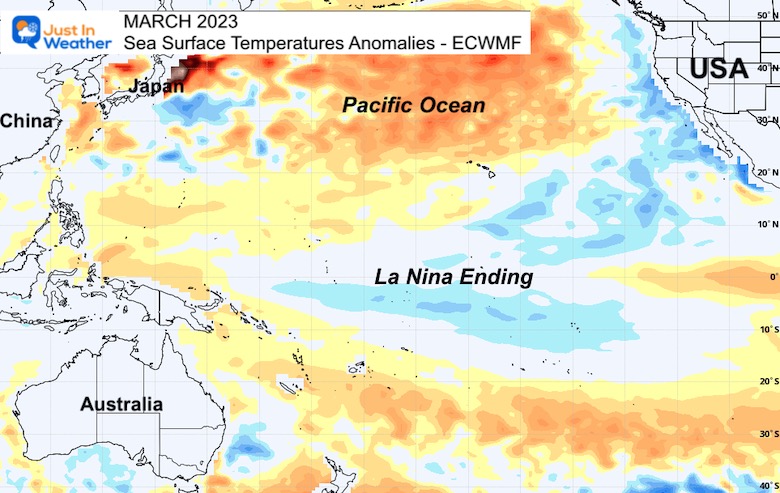
The La Niña is when the tropical Pacific Ocean sea surface temperatures are cooler than average. That is where we are now, but rapidly trending to neutral, then warming.
Still below average, but modifying.
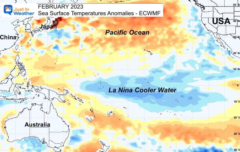
Trending to neutral which would bring La Niña to an end.
The majority of models (19 out of 23) in the IRI ENSO prediction plume predict SSTs to transition from the level of a La Niña to ENSO-neutral state during Feb-Apr, 2023.
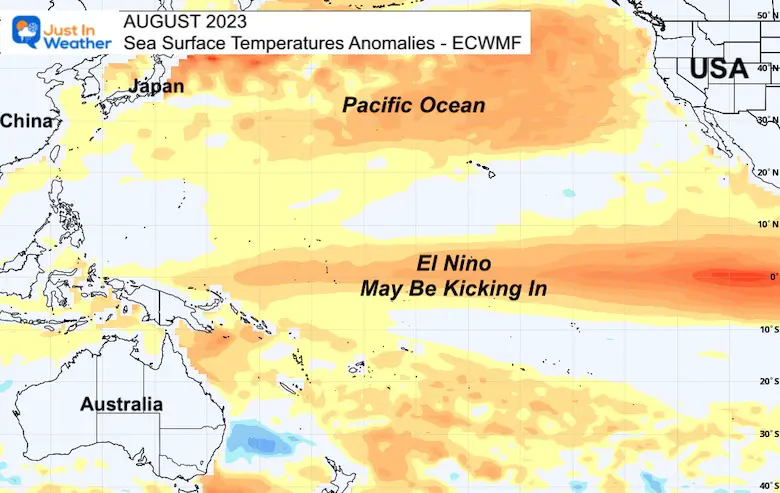
Notice the rapid warming through spring and summer. This suggests a flip to El Niño conditions.
If this warming forecast verifies, the flip to El Niño will have larger implications for the tropics. Often that means lower than average hurricane activity in the Atlantic. That would be welcome news for our part of the world.
I have been firm for many months about my lack of confidence in long-range model plots. This continues to prove true. The global patterns, however, are more reliable farther out in time.
I understand the mention of The Polar Vortex conjures up expectations of The Day After Tomorrow. While we have had a few episodes, they have been brief visits.
Winter has been baffling by simply NOT being able to hold. That has not been the case for other parts of the country; we have just been on the mild side.
We can blame La Niña for being a prominent force. As it wanes, we can expect any impulse of colder air to have a better chance to be sustaining. This may also mean that we end up with a cooler start to spring. That does seem to be a rather frequent occurrence for us in the Mid-Atlantic.
Faith in the Flakes
Latest Measurable Snow In Baltimore
The 2nd place year was 1914 (109 years ago). To give you some hope, or Faith in the Flakes, I would like to expand on that winter.
Mid Winter Record Warmth
72ºF on January 30, 1914 – Record High
Imagine that those people thought that winter?
Well, they broke their snow drought on February 6th, 1914, then made up for lost time!
11.4” Snow fell in February
11.6” Snow fell in March.
That season ended with 23 inches, which was above an average winter.
Winter History: Low Snow And Late Starts
See my research based on Baltimore data since 1883.

Click to see more and ‘Book’ a visit to your school

I see many factors to support colder influence with multiple systems. Early and later in winter. Check it out.
Atmospheric Memory Suggests Active Winter Storm Pattern Outlook
Winter Outlook 2023 From NOAA Very Different Than Farmers Almanacs
Winter Outlook 2023 Early Look At Snow From Two Farmers Almanacs
https://justinweather.com/2022/09/09/winter-outlook-2023-la-nina-triple-dip-expectations/
If you want a snowy winter, this is what you might want to look for in the rest of the tropical season.
Record August For No Named Tropical Storms: Closer Look At Snow Following
Winter Weather Folklore Top 20 And More Outlook Signals From Nature For Cold And Snow

