


Severe Thunderstorm Watch and Flood Watch Tuesday
Tuesday Afternoon Update July 1 2024 The atmosphere is juicy! Dew points are high in the mid to upper 70s, which means there is the potential for heavy rainfall and…
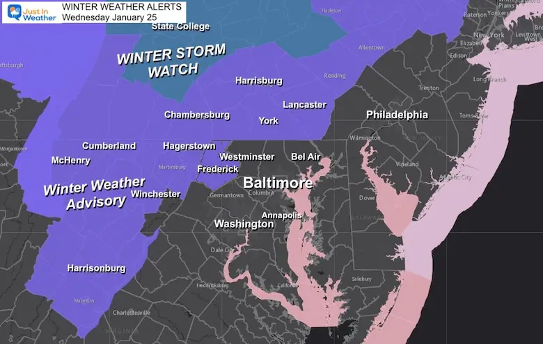
January 24, 2023
Tuesday Night Update
Stop me if you heard this before: Timing Is Key! That has been the best way for me to describe this winter weather event for our areas given the arrival in the morning. Simply put: If this arrived earlier in the morning, temperatures would be cool enough to support snow and some stickage. That would lock in the cold air longer (a few more hours), then change to rain.
With the arrival after 9 or 10 AM, that allows those places to warm just enough to remain wet.
If you have read my weather reports since this summer, I have often mentioned that storms have arrived an hour or two earlier than the models suggestion. I am still in that ‘early’ camp, but it may not be early enough for much in Central Maryland. However the mountains of Frederick County will catch the edge. I will still be up early on Wednesday to track along the way.
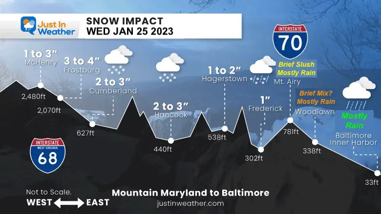
Please see my Snow Profile Map and weather forecast plots below.
Please bear with me as I want to explain this to you.
Personally, I have been working on this all day, and have an obligation to my clients who plow roads and make school decisions. I also have a large area that I cover, so when I mention snow and you don’t get it, there are areas in my forecast region that will (this time). We also have Taco Tuesday in my house, so I lost some work time to cooking and clean up.
I hope these graphics help.
There may be a brief THUMP of snow between Frederick, Mt. Airy, and Westminster for an hour or two. When that arrives, temps will be close to freezing, but trying to warm up. That is why I wrote ‘Brief Slush’.
Click here for the full report
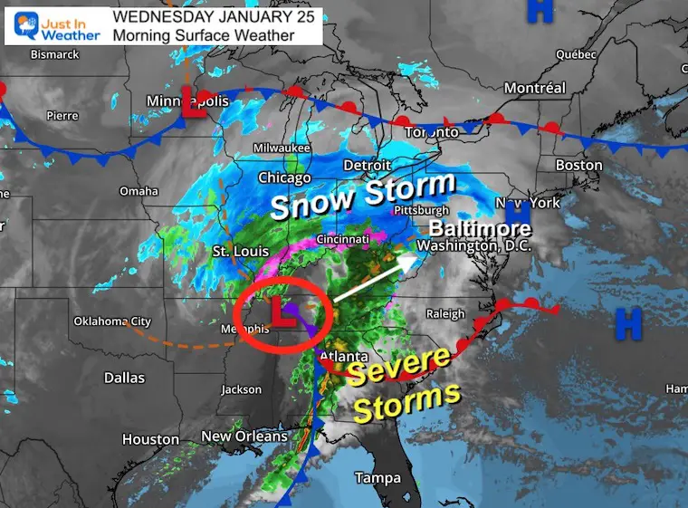
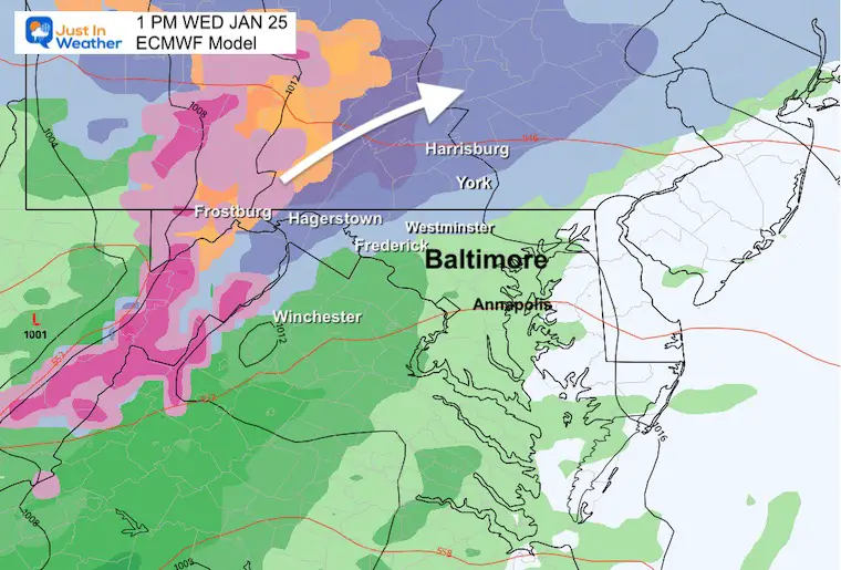
This is a pattern change even with the inland storm track. I get the frustration from many that the result is still the same… A cold rain for the cites.
The initial early snow will ride up the mountains and expand across central PA before sunrise, that will allow that region to hold the cold longer.
This is an important factor to highlight why the timing of the arrival is so pivotal.
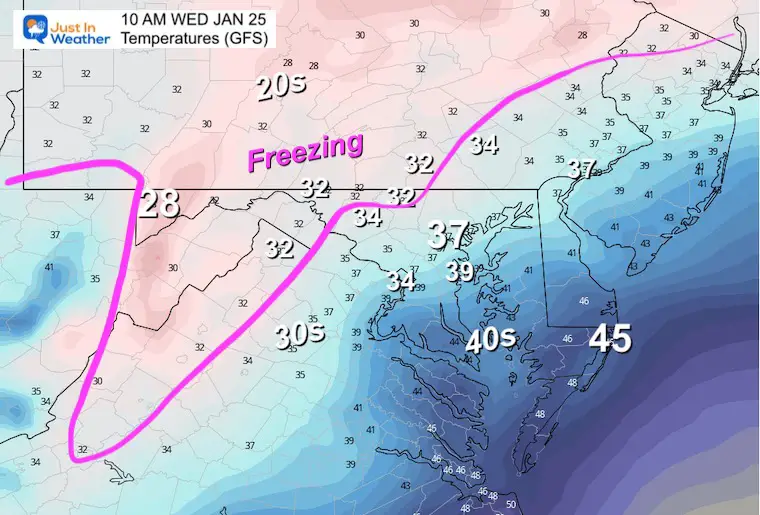
At sunrise, there will many locations at or below freezing (32ºF). The snow needs to arrive within 2 hours of sunrise to tap into this, before any warming can take place.
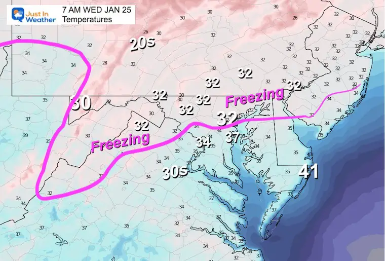
This is the realistic forecast for the modifying air. Notice the bump above freezing. There will be a possible thump of snow in areas just above 32ºF, but which may lead to a hour or two of slush… But later in the morning, the ground temps will battle hard to keep the pavement wet.
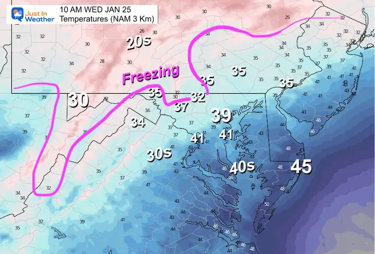
If we follow the ‘slow theory’, then we can suggest snow reaches Frederick and may expand to Westminster and York close to, or before 10 AM.
Those northern areas that get the early snow, may hold the snow into the afternoon while temps do bump above freezing. So after the ‘thump’, there could be a coating that will gradually melt.
This lines up very closely to my ‘Most Likely’ Impact map.

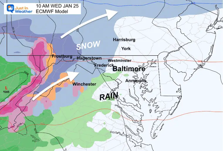
I think the arrival will be between 8 and 10 AM into Frederick County, MD. These model plots may still be an hour or two slow.
This shows that leading edge into Frederick.
The leading edge across the Catoctin Ridge, with steady snow along I-81 to Hagerstown and Winchester.
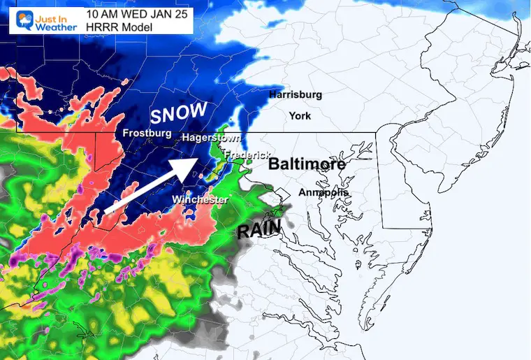
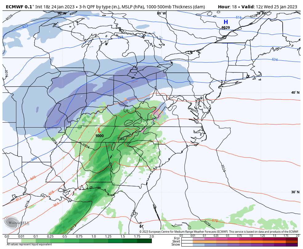
This model is a little thin with the leading precipitation. I believe this output is under performing.
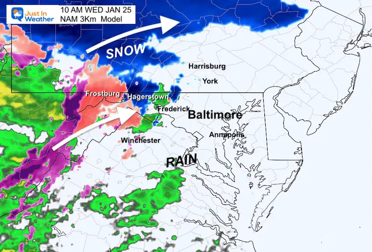
This model is aggressive with the heavier precipitation. There will be heavy rain in the afternoon and it is possible for some thunder and lightning at night.
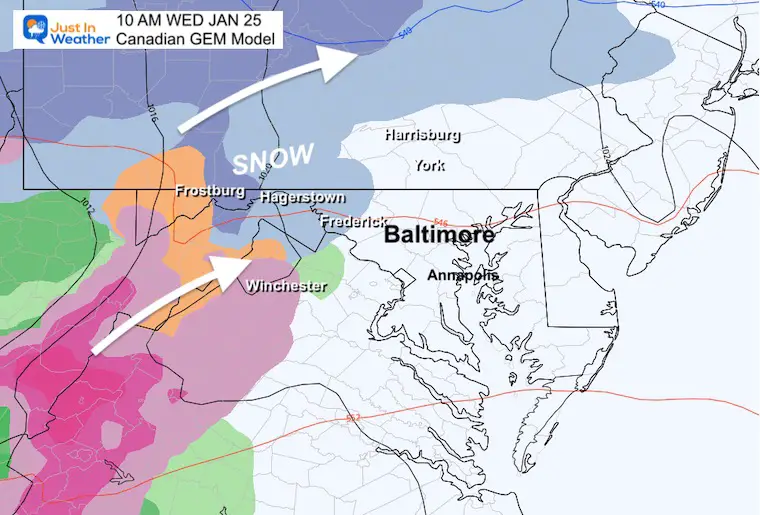
This is the model that continues to be faster with the storm and more robust with the snow.
While I showed this had a win with the timing this afternoon, I must concede this solution is the outlier and too aggressive. I am showing it to you for ‘what could have been’ but likely not to happen.
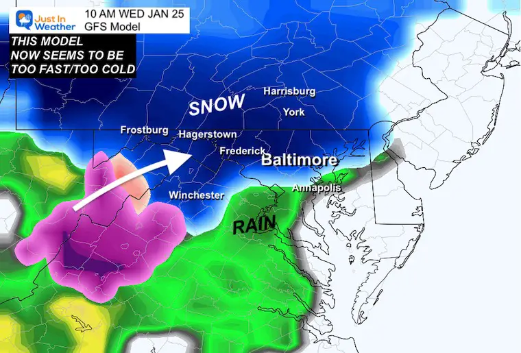
The earlier snow would have allowed the temperatures to remain cold into the afternoon. This was what snow lovers wanted.
TIMING! One or two hours faster could make a big difference. This will arrive after sunrise and perhaps at the end or after the morning commute for central Maryland.
We may get a THUMP of snow with temps above freezing, and that could coat the ground.
If you get that burst, it will warm up and change to rain during the afternoon.
So for schools in central Maryland and southern PA, you might get in on time, see the snow, then have it be just wet when it is time to leave.
If you are traveling west on the Interstates, you may have a snow burst around Mt. Airy between 9 AM and 11 AM with a brief coating. The travel might be more of an impact near and west of Frederick. Especially up the mountains and westward. Timing between 6 AM and 9 AM is when this will begin to affect the roads.
There is plenty of winter ahead. Time is running low, but we are not done yet. FITF
Winter History: Low Snow And Late Starts
See my research based on Baltimore data since 1883.


Click to see more and ‘Book’ a visit to your school

I see many factors to support colder influence with multiple systems. Early and later in winter. Check it out.
Winter Outlook 2023 For Snow Not Typical La Niña Plus Polar Vortex Disruption
Winter Outlook 2023 From NOAA Very Different Than Farmers Almanacs
https://justinweather.com/2022/09/09/winter-outlook-2023-la-nina-triple-dip-expectations/
If you want a snowy winter, this is what you might want to look for in the rest of the tropical season. (You might be seeing a lot of commercial snow removal people out this Winter).
Record August For No Named Tropical Storms: Closer Look At Snow Following
Winter Weather Folklore Top 20 And More Outlook Signals From Nature For Cold And Snow
