


May 2 One More Hot Day Then The Cool Down And Rain For The Weekend
Thursday May 2 Morning Report This is one of those days where we get a little surprise. The old air mass is holding strong and will allow one more hot…
November 29 2022
Tuesday Night Update
Another storm in this cycle will pass through the region on Wednesday. If you haven’t noticed, we seem to be on the cycle of 3 days AND getting that rain to arrive in the morning. We also have these systems followed by strong winds!
This one has the history of severe weather on Tuesday afternoon in the Southern US. It will be followed by an air mass with enough cold and dense air that it will help to push wind gusts close to 50 mph. As of the time of this post, the only “Advisory” in the region is in Maryland from Frostburg to Garrett County and all Skyline Drive in Virginia. Considering the data I will show below, this is worth paying close attention to for possibly expanding on Wednesday.
This may be updated on Wednesday
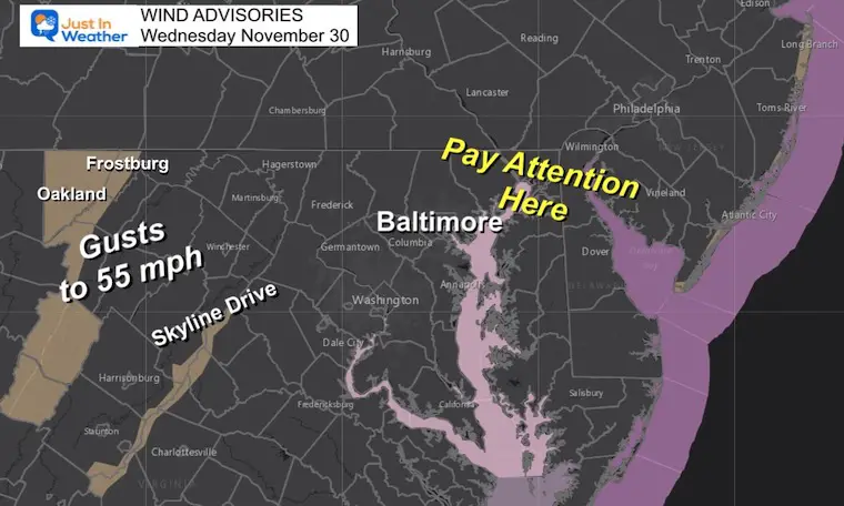
If you have put up outside decorations already, you may want to secure them. If you drive a truck or high profile vehicle over area bridges, there my be restrictions put in place as well, so check ahead.
Here is a brief look at the timing and what to expect during the day Wednesday. I will have my full daily report posted at my normal time around 6:30 AM.
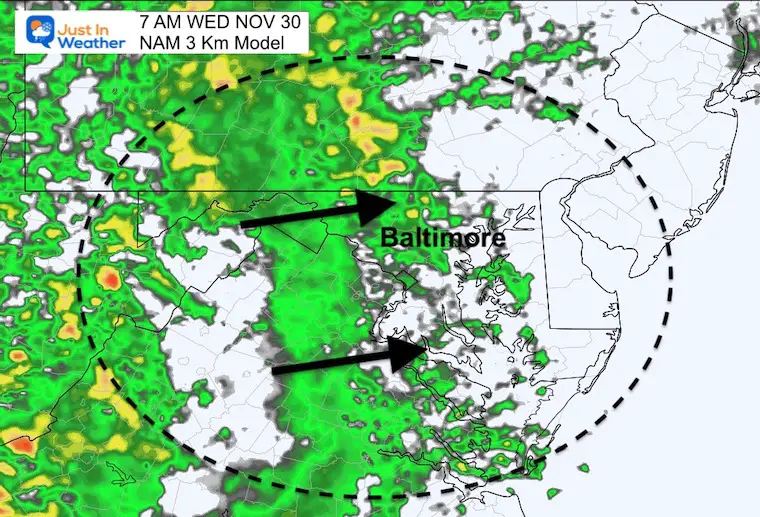
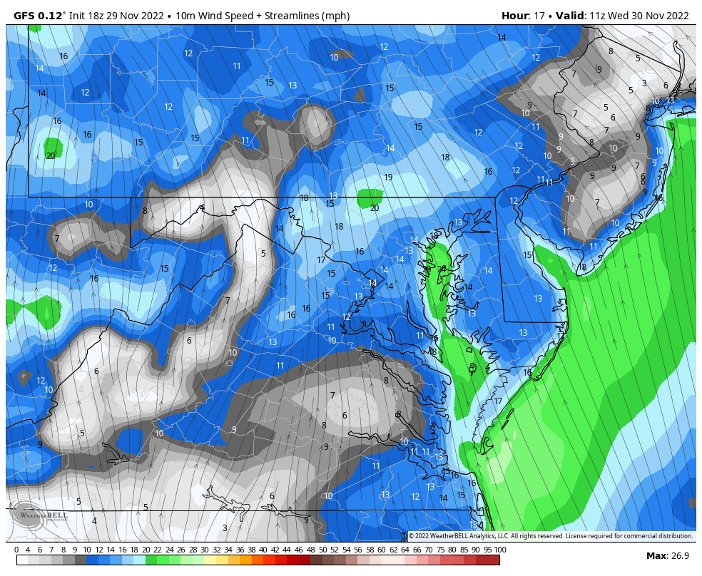
The GFS Model at 7 AM shows the cold front bringing the leading edge of rain into metro areas for the commute.
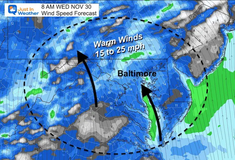
The day will start with warm winds bringing in the rain, with the cold winds worth watching in the Ohio Valley.
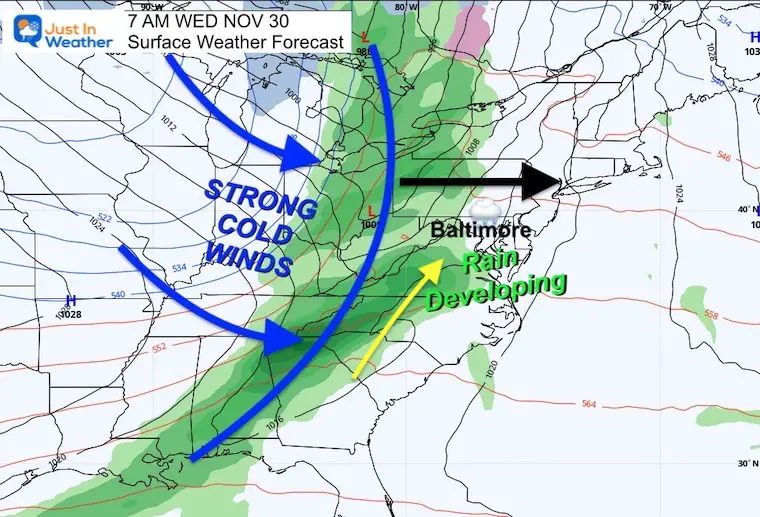
These will be from the south and already breezy (10 to 20 mph). That will feed in the moisture but also bring mild temperatures.
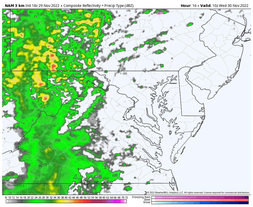
Note the 7 AM time stamp, but we continue to monitor weather events possibly arriving an hour or so early. Plan for a wet commute.
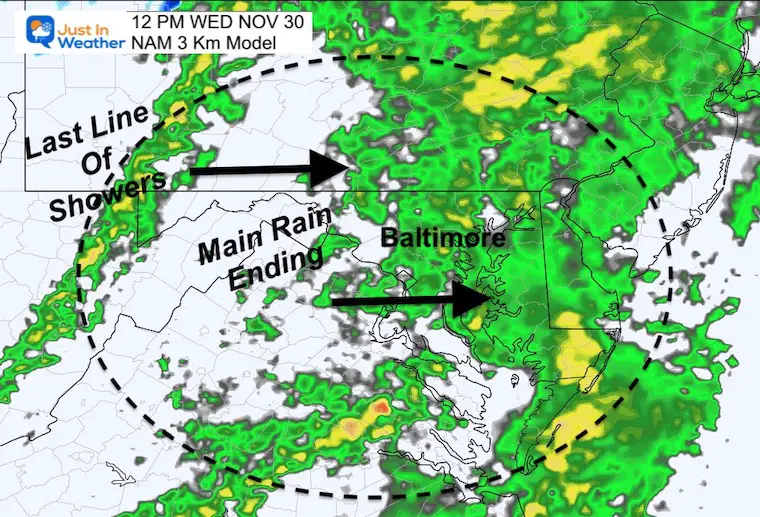
Note the 12 PM time stamp with the bulk of steady rain near Baltimore and across Delmarva to metro Philadelphia.
This breaks up in the western suburbs and that will expand east early in the afternoon.
One last line of rain is the actual cold front, reaching western Maryland.
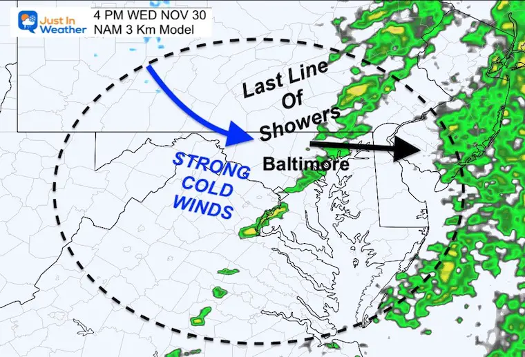
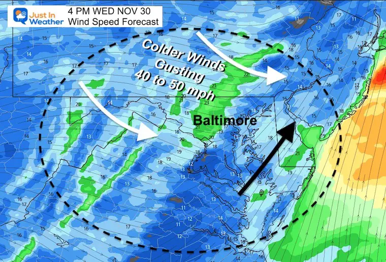
Note the 4 PM time stamp with that last line moving through metro Baltimore/Central Maryland.
This is when the strongest winds and temperature drop will occur.
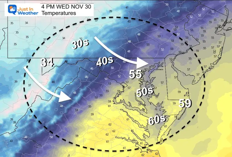
Also at 4 PM, we can see the temps in the mid 50s to near 60ºF just ahead of that rain line.
On the other side, the wind shift and quick drop into the 40s. The 30s will reach the higher mountains above 2,000 Ft.
At 4 PM: With the line of rain and just behind it, the Winds will be steady over 20 mph as they swing to the Northwest.
6 AM to 8 PM
Wind will increase all morning and peak with the FROPA (frontal passage) in the afternoon. That wind shift will be the most noticeable event and could lead to some tree branches getting knocked down as well.
These are the forecast steady wind speed numbers. Brief gusts will be higher as noted below.
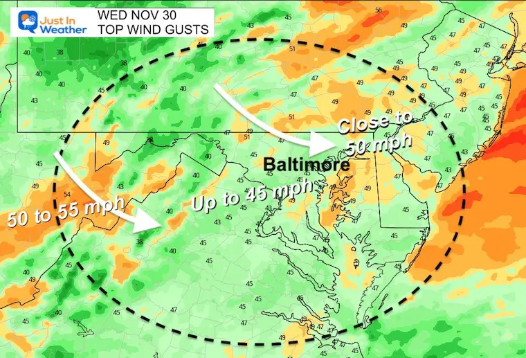
The forecast winds for much of the area is to gust over 40 mph. There will be spots in the 45 to 50 mph range.
It is because of this expectation that there may be minor wind damage, lost holiday decorations, and some bridges may enforce restrictions for larger vehicles.
While I expect Fropa to be the most significant part of the day. There can be some mini damage leading up to it from late morning through mid afternoon.
Subscribe to my Newsletter
How The Winter Weather Pattern May Develop In Early December
Record Snow Cover Across The Northern Hemisphere
I see many factors to support colder influence with multiple systems. Early and later in winter. Check it out.
Winter Outlook 2023 For Snow Not Typical La Niña Plus Polar Vortex Disruption

Atmospheric Memory Suggests Active Winter Storm Pattern Outlook
Winter Outlook 2023 From NOAA Very Different Than Farmers Almanacs
Winter Outlook 2023 Early Look At Snow From Two Farmers Almanacs
If you want a snowy winter, this is what you might want to look for in the rest of the tropical season. (You might be seeing a lot of commercial snow removal people out this Winter).
Record August For No Named Tropical Storms: Closer Look At Snow Following
Winter Weather Folklore Top 20 And More Outlook Signals From Nature For Cold And Snow


Click to see more and ‘Book’ a visit to your school
