


May 4 Chilly And Wet Weekend: Live Radar
Saturday May 4 Morning Report May the 4th Be With You! There is a definite change in the Force we all will notice this morning. A band of rain has…
Wednesday Evening September 28
Hurricane Ian made landfall today and continues to track through Florida on a destructive path to the Atlantic Ocean tomorrow. Yes, it looks like there will be a return to the water then a second landfall up the coast as it curves North.
The purpose of this post is a brief update on the Hurricane, forecast across Florida to a second landfall on South Carolina, then the forecast through this weekend here in the Mid Atlantic. We have been debating the arrival of the rain in Maryland and possible impact into early next week. We are still in for some heavy rain. Let’s take a look.
The eye of Ian is tracking inland across Florida. As of Thursday evening, 1.9 million customers in Florida have lost power. There will be more!

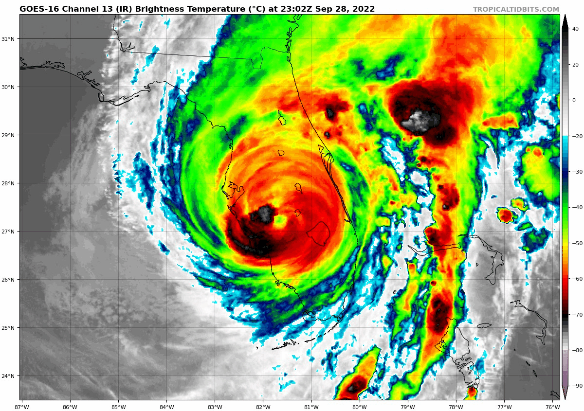
See The Landfall: Click for the radar loop and two fascinating vides of opposite Storm Surges
Hurricane Ian Made Landfall On Captiva Florida: Doppler Radar And Amazing Surge Video
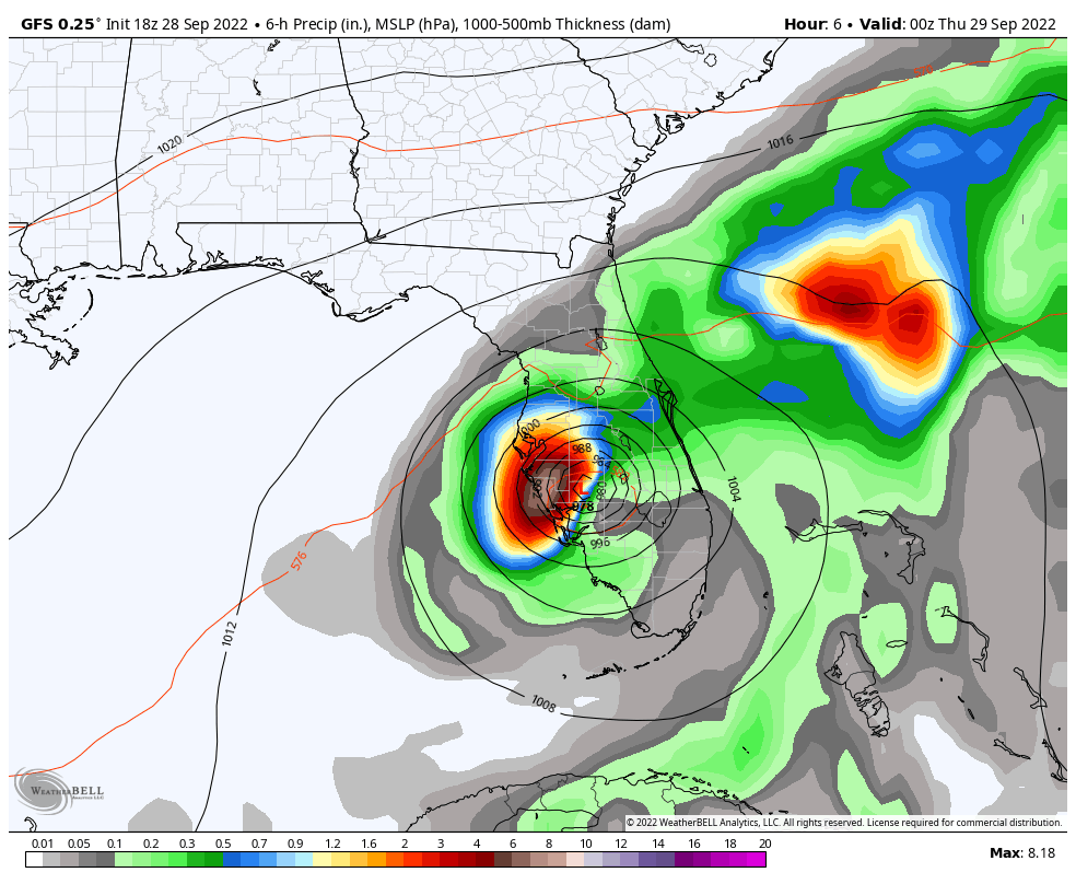
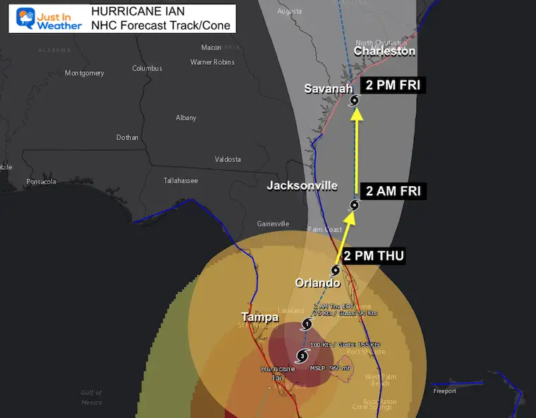
Hurricane Ian will gradually weaken overnight as it passes to the south and east of Orlando. It should reach the Atlantic coast near Daytona later on Thursday, then curve along the coast to make a second US landfall between Savannah and Charleston.
Hurricane Ian will gradually weaken overnight as it passes to the south and east of Orlando. It should reach the Atlantic coast near Daytona later on Tuesday, then curve along the coast to make a second US landfall between Savannah and Charleston.
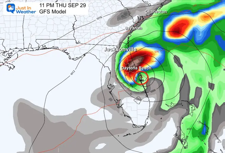
This is slower than the NHC Track, but I wanted to highlight a few elements.
This plot is up for debate… The center of Ian should reemerge over the Atlantic between Cape Canaveral and Daytona Beach. Here we see it along the coast at 11 PM, while the National Hurricane Center is calling for a faster track and it reaching the water during the afternoon.
The center of Ian will be East of Jacksonville, FL. A strong Easterly wind on the coast will create additional problems. This is why a storm surge up the St. Johns River is expected.
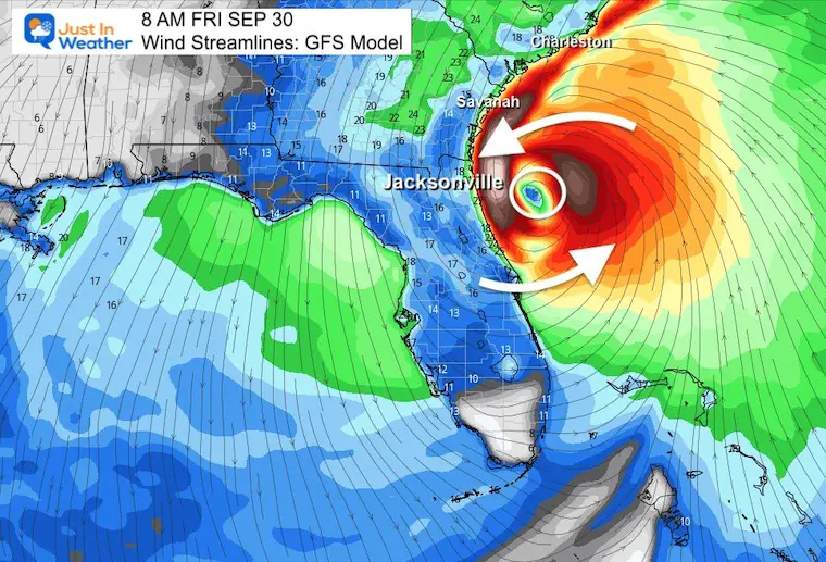
Landfall or already inland between Savannah, GA and Charleston, SC.

This is when we need to expand the view to see how this large system will expand into the Mid Atlantic.
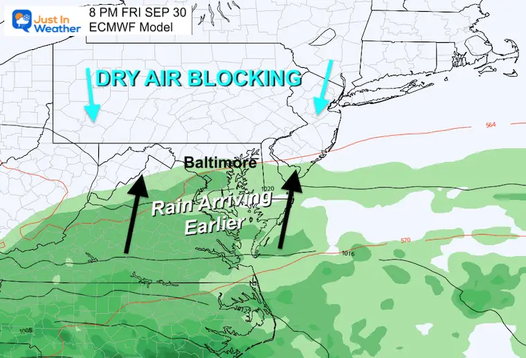
High Pressure in New York and New England will still block the rain, but it looks like that may be allowed to track in faster and farther north. It may be the start of a soggy day and weekend.
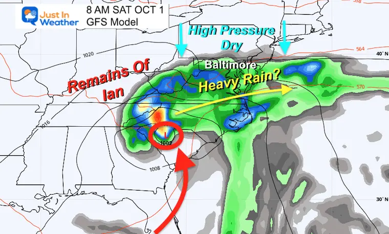
The Atlantic Tropical Cyclone Model Guidance shows this possibly looping around and then tracking to the coast south of Baltimore.
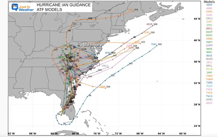
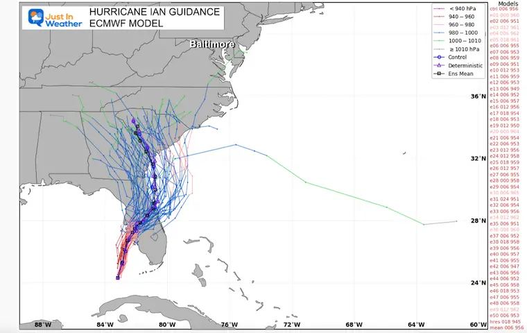
We are going to pick up the European Model to track this rain through the weekend and into next week.
Ian will lose tropical characteristics, but the remnant Low is important to keep tracking for possible redevelopment.
With Hurricane Ian making progress to the Atlantic and picking up more moisture, it looks like rain will get into Maryland earlier.
That Blocking High now appears to lose its grip as the weekend begins. The concert in Ocean City will be damp in addition to a chilly wind off the water.
Much of our region will be on the edge of rain from Ian. Despite the tropical source, it will be chilly!
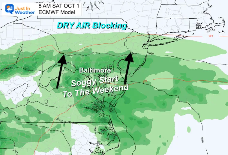
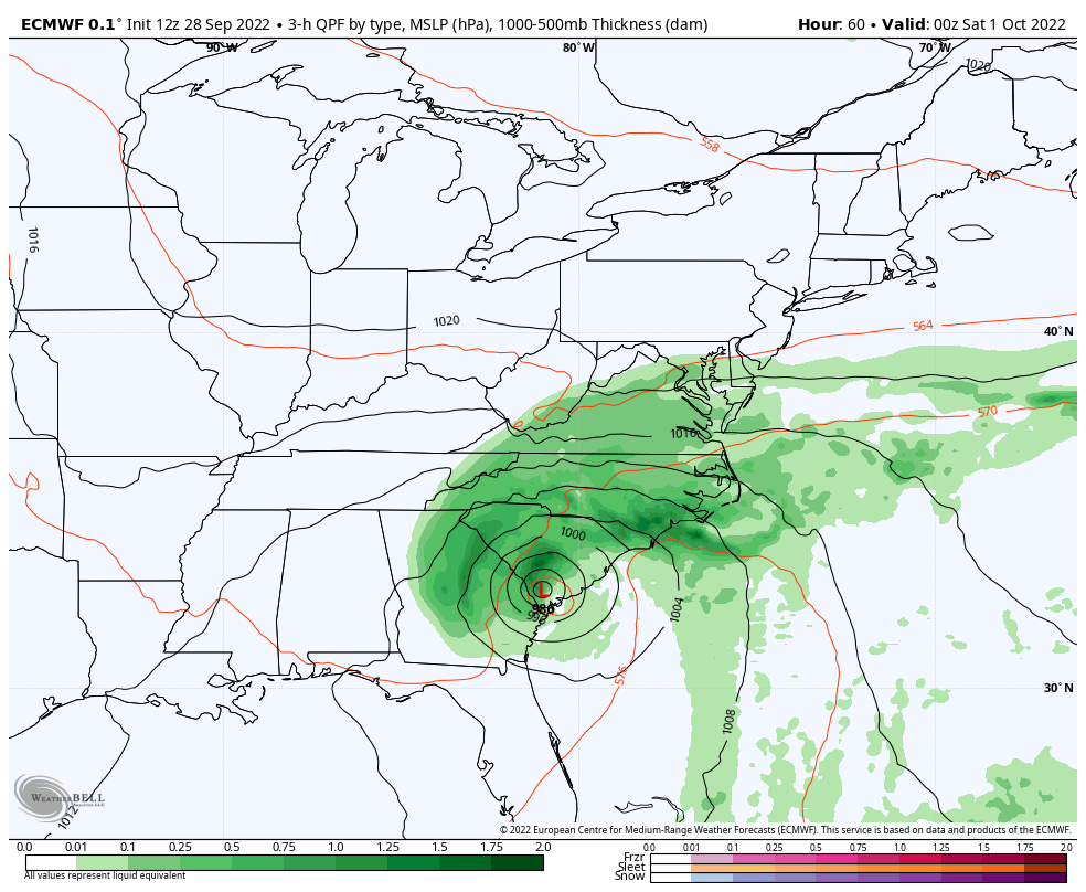
The rain will arrive late Friday and Saturday into Maryland. The primary Low may get stuck in the Ohio Valley while the initial moisture moves to and off the coast.
This Low has a chance to redevelop as it moves to the coast. A second burst of rain will try to form Sunday into Tuesday.
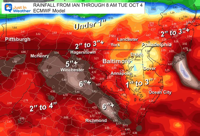
This is a summary of rain over four days: A few inches or more could still lead to flooding.
Hurricane Ian May Help Cooler Pattern Change: Monitor For Atmospheric Memory This Winter
If you want a snowy winter, this is what you might want to look for in the rest of the tropical season.
Record August For No Named Tropical Storms: Closer Look At Snow Following
NOAA 2022 Hurricane Forecast- Above Normal Again

NOAA Study: Reducing Air Pollution INCREASED Tropical Storms

Atlantic Tropical History: Maps of Origin Regions Every 10 Days


Click to see more and ‘Book’ a visit to your school
