


July 18 Flood Watch In The Mountains Then Storms Expand Back This Weekend
Friday, July 18 2025 Morning Report There is some relief in sight, but I remain cautious. For the short term, today remains muggy, while the focus of strong storms and…
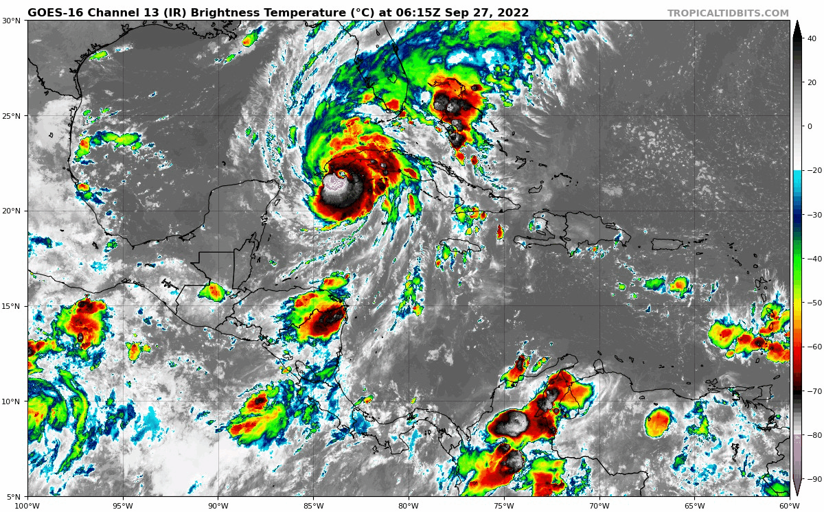
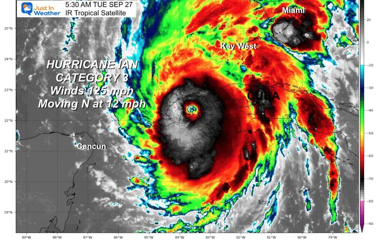
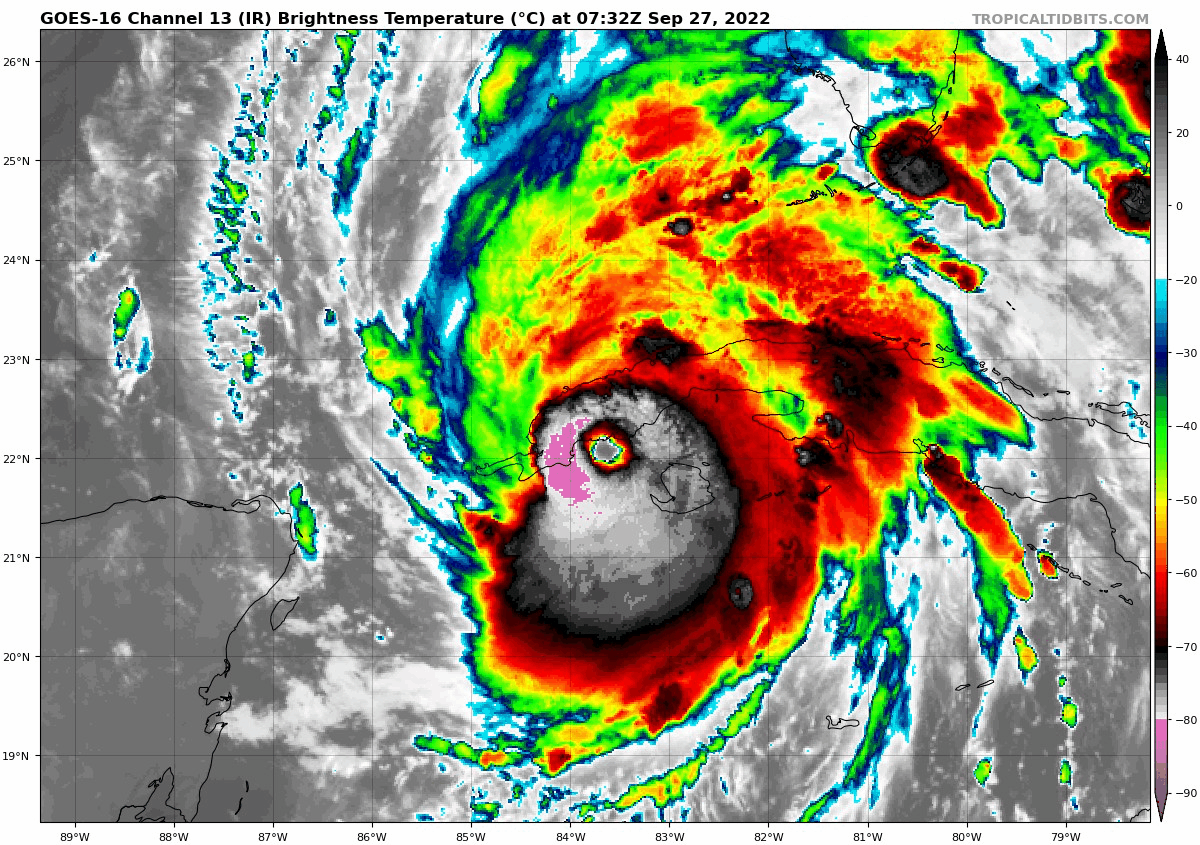
Tuesday Morning September 27 2022
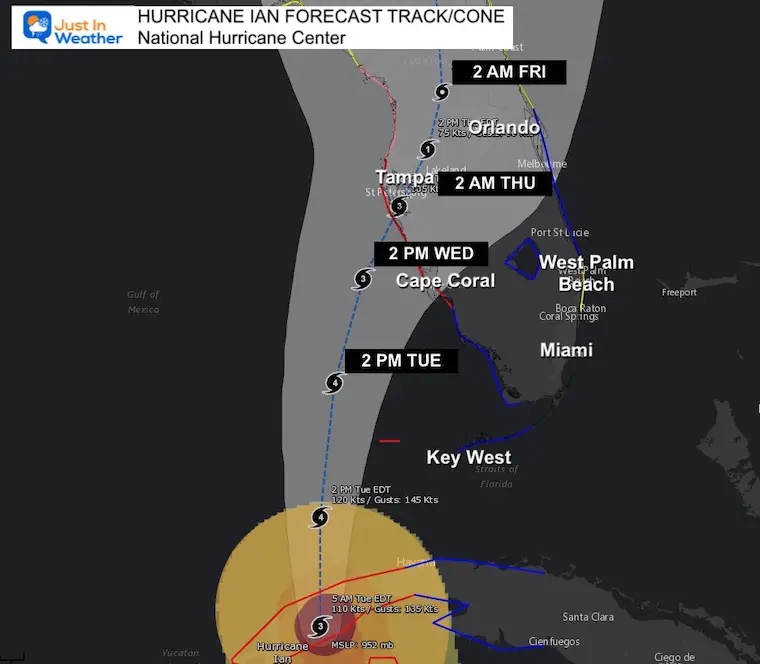
Hurricane Ian has reached Category 3 as of Tuesday morning, making this a major hurricane. The track has changed a little again and now could make landfall SOUTH of Tampa! That is why mandatory evacuation orders were put in for areas around Tampa. Governor DeSantis and FEMA encouraged people to move 20 miles inland due to flooding.
Damage and destruction will come from storm surge flooding, heavy rain flooding, widespread winds (not all hurricane intensity), and isolated tornadoes.
Rainfall forecast totals have dramatically increased as a result of the timing, slow down or stalling, and intensity.
Here are the latest details:
Click here to see how heavy rain may spread north this weekend. I will have a full update in the 7 AM hour.
The eye wall structure is much better organized.
This has CHANGED – AGAIN! Now the turn puts it SOUTH OF TAMPA…
There is still a WIDE CONE OF UNCERTAINTY! That means this may not track along that center line, but anywhere in that light gray shading.
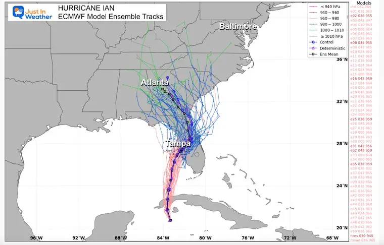
European ECMWF Model
This tracks the eye inland south of Tampa, then curves NW to Atlanta.
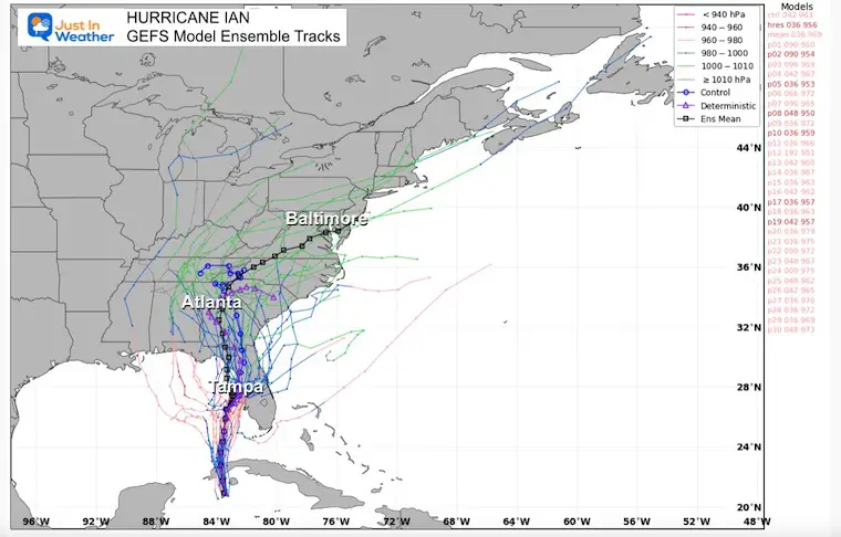
This tracks the eye just offshore from Tampa and along the west coast of Florida. The remnant Low crosses Maryland by the end of the weekend.
The Hurricane Warning has been extended southward along the west coast of Florida to Bonita Beach.
A Tropical Storm Warning has been issued for the Middle Florida Keys from the Channel 5 Bridge westward to the Seven Mile Bridge.
A Tropical Storm Warning has been issued for the west coast of Florida from the Anclote River northward to the Suwannee River.
A Tropical Storm Warning has been issued along the east coast of Florida from Jupiter Inlet to the Volusia/Brevard County Line, including Lake Okeechobee.
A Tropical Storm Watch has been issued for southeast coast of Florida from Deerfield Beach northward to Jupiter Inlet.
SUMMARY OF WATCHES AND WARNINGS IN EFFECT:
A Hurricane Warning is in effect for…
* Cuban provinces of Isla de Juventud, Pinar del Rio, and Artemisa
* Bonita Beach to the Anclote River, including Tampa Bay
* Dry Tortugas
A Storm Surge Warning is in effect for…
* Anclote River southward to Flamingo
* Tampa Bay
A Tropical Storm Warning is in effect for…
* Cuban provinces of La Habana, Mayabeque, and Matanzas
* Lower Florida Keys from Seven Mile Bridge westward to Key West
* Flamingo to Bonita Beach
* Suwannee River to the Anclote River
* Volusia/Brevard County Line south to Jupiter Inlet
* Lake Okeechobee
A Storm Surge Watch is in effect for…
* Florida Keys from the Card Sound Bridge westward to Key West
* Dry Tortugas
* Florida Bay
* Aucilla River to Anclote River
* Altamaha Sound to Flagler/Volusia County Line
* Saint Johns River
A Hurricane Watch is in effect for…
* North of Anclote River to the Suwannee River
A Tropical Storm Watch is in effect for…
* North of the Suwannee River to Indian Pass
* Altamaha Sound to Volusia/Brevard County line
* Deerfield Beach to Jupiter Inlet
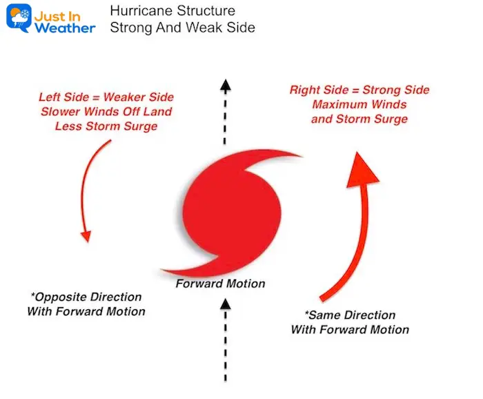
With respect to forward motions, the RIGHT (East in this case) has the winds and water moving with the forward direction. This will bring the maximum impact to Florida. The LEFT (West in this case) side has the wind and water flow opposing the forward motion, thus contradicting itself and resulting in weaker impact. This will be over the open Gulf.
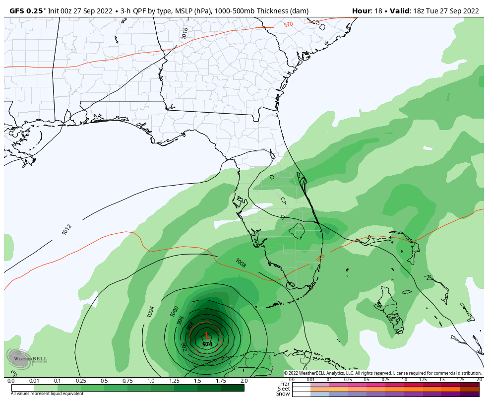
Forecast Animation: GFS Model 2 PM Tue to 2 PM Sat
My concern here is the adjustment back south with landfall. Two days ago, this was shifting west and north. The latest model guidance shows landfall SOUTH OF TAMPA.
The GFS Model still shows a near stalling most of Thursday. That would be devastating for western Florida and also dramatically increase the rainfall.
FLOODING
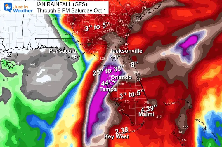
Rainfall Forecast
The totals have increased A LOT with the adjustment and track/stalling. Today we need to watch for any slight adjustment in speed and track.
Yes, that is a 44 INCH Rainfall forecast for Tampa! Plus 25 to 35 inches on their north side, possibly including inland to Orlando.
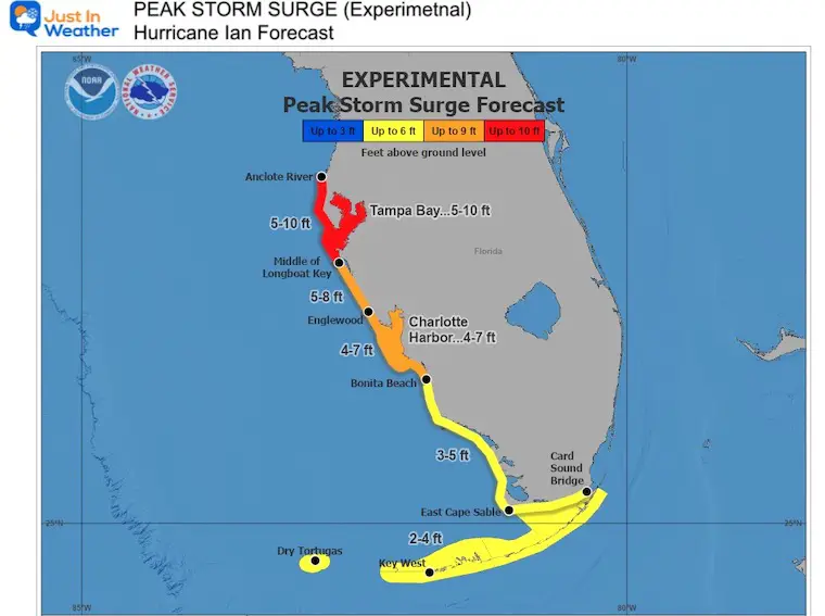
Storm Surge Forecast (a new map will be issued today to reflect higher numbers)
Storm surge could raise water levels by as much as 9 to 14 feet above normal tide levels along the coast of western Cuba in areas of onshore winds in the hurricane warning area early today.
National Hurricane Center Forecast Notes:
RAINFALL:
Ian is expected to produce the following rainfall through Thursday night:
* Western Cuba: 6 to 12 inches, with local maxima up to 16 inches. These rains may produce flash flooding and mudslides in areas of higher terrain over western Cuba.
* Florida Keys and South Florida: 4 to 6 inches, with local maxima up to 8 inches
* Central West Florida: 12 to 16 inches, with local maxima up to 24 inches.
* Northeast Florida and the remainder of the Central Florida Peninsula: 5 to 10 inches, with local amounts up to 12 inches.
Heavy rainfall is expected to affect the Southeast Friday and Saturday.
Widespread considerable flash and urban flooding are expected mid-to-late week across central and northern Florida, southern Georgia, and coastal South Carolina, with significant, prolonged river flooding expected across central to northern Florida. Flash and urban flooding are also expected with rainfall across southern Florida through mid week. Limited flash and river flooding is expected over portions of the Southeast into the Mid-Atlantic mid-to-late week.
If you want a snowy winter, this is what you might want to look for in the rest of the tropical season.
Rainbow Ice Cave In Mt. Rainier A Very Rare Find: Photos And Video
Sign up and be the first to know!
NOAA 2022 Hurricane Forecast- Above Normal Again

NOAA Study: Reducing Air Pollution INCREASED Tropical Storms

Atlantic Tropical History: Maps of Origin Regions Every 10 Days


Click to see more and ‘Book’ a visit to your school
