


May 3 Cooler Today Then More Rain Expected This Weekend
Friday May 3 Morning Report Another record high of 90ºF was reached yesterday at BWI. This tied the mark set in 2018. Today, a cooler wind will bring us closer…
Tuesday September 27 2022
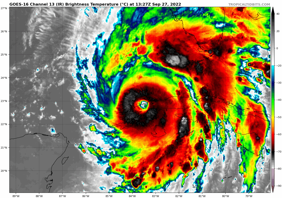
The eye of Hurricane Ian has emerged back over the water north of Cuba and is showing two interesting things. First, at 11 AM we can see a well-defined, also known as a healthy eye wall structure. This means it is ripe for continued strengthening. We can see the eye on the live radar widget below.
Secondly, the movement seems to have shifted a little East (right) of due North. This subtle change may play a role with the impact on Florida and the path farther north up the Eastern US. I know I had been saying we have noticed storms trend west of the forecast track. This did and has come back east. Landfall more likely SOUTH of TAMPA now.
If this east trend continues it may end up on the Atlantic side of Florida over the weekend.
The pressure is up and the winds are down a little, as was expected after the trip through Cuba. This is forecast to quickly become a Category 4 storm today. It is easy to believe that looking at this:
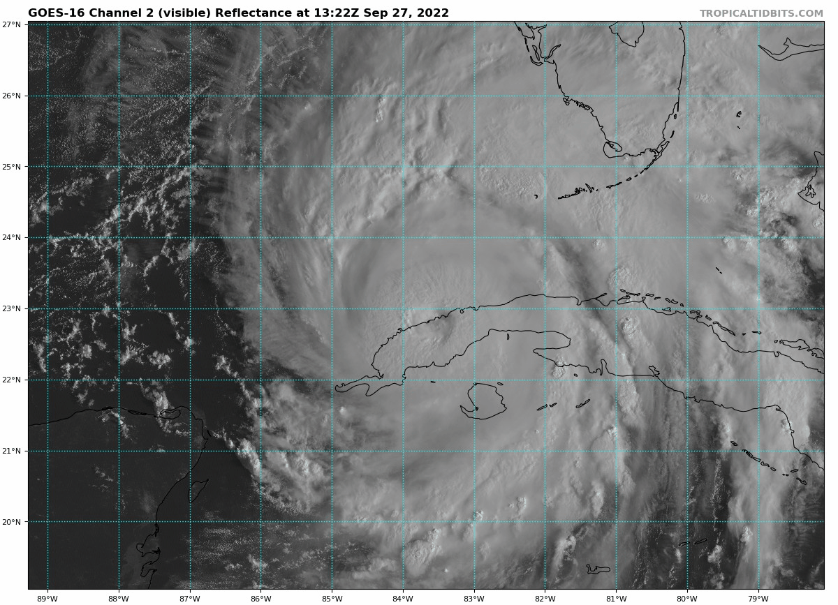
Visible Satellite Loop 9:22 AM to 10:57 AM
This shows the eye wall back over the water north of Cuba.
Among the other points that need to be addressed:
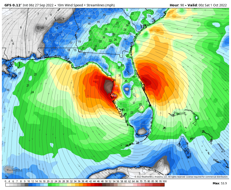
Size of the impact region…. For 100 miles of coastline under a Hurricane Warning, about 30 miles closest to the eye wall will see the true full force!
The hurricane force winds are confined closest to the center around the eye wall. As of this 11 AM report, that is 35 miles wide. Tropical Storm force winds (39 to 73 mph) reach father out. This will play a role in the wind damage but also the high water being pushed up ahead of the storm. The Peak Storm Surge will be in that eye wall region to the right of the eye at landfall.
The last few frames shows a wobbling eye wall becoming more symmetrical. That is a signal of organization and intensification potential.
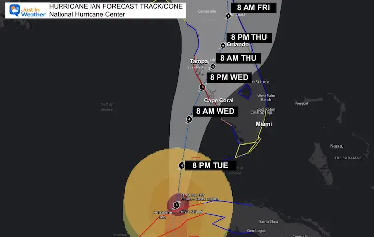
This shows landfall Wednesday evening and nearly stalling all day Thursday, then ending up near Orlando Friday Night.
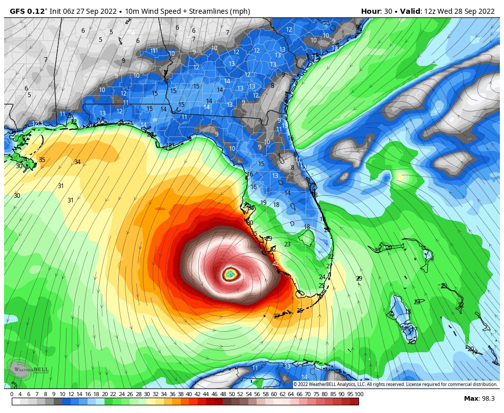
There is support for this to get close to the Atlantic ocean or emerge over the water to restrengthen.
Notice the shift across Florida. This changes the timing and location farther north…
We may have a delay in the rain arrival in the Mid Atlantic this weekend and need to reevaluate the impact beyond that.
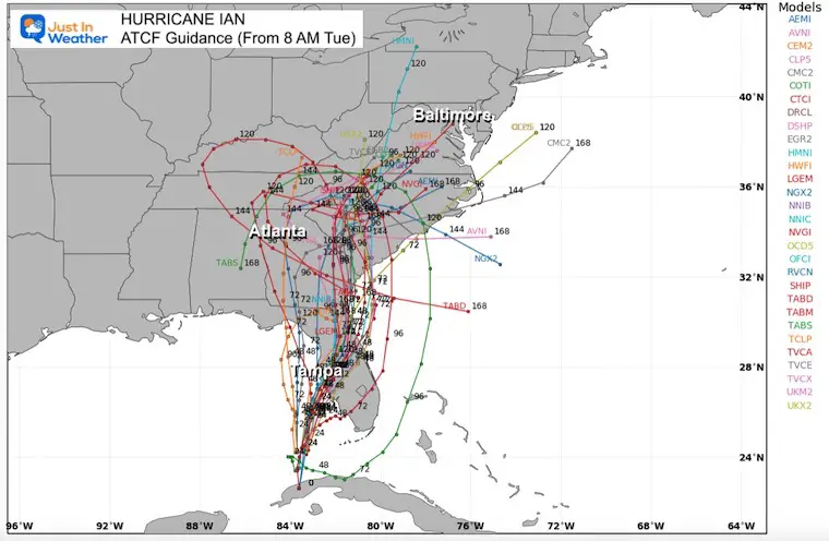
This has CHANGED – AGAIN! Now the turn puts it SOUTH OF TAMPA…
Approaching the Atlantic coast is open for for discussion, and could lead to storm surge up the East Coast.
The Hurricane Warning has been extended southward along the west coast of Florida to Bonita Beach
A Tropical Storm Warning has been issued for the Middle Florida Keys from the Channel 5 Bridge westward to the Seven Mile Bridge.
A Tropical Storm Warning has been issued for the west coast of Florida from the Anclote River northward to the Suwannee River.
A Tropical Storm Warning has been issued along the east coast of Florida from Jupiter Inlet to the Volusia/Brevard County Line including Lake Okeechobee.
A Tropical Storm Watch has been issued for southeast coast of Florida from Deerfield Beach northward to Jupiter Inlet.
SUMMARY OF WATCHES AND WARNINGS IN EFFECT:
A Hurricane Warning is in effect for…
* Cuban provinces of Isla de Juventud, Pinar del Rio, and Artemisa
* Bonita Beach to Anclote River, including Tampa Bay
* Dry Tortugas
A Storm Surge Warning is in effect for…
* Suwanee River southward to Flamingo
* Tampa Bay
* Dry Tortugas
* Marineland to the mouth of the St. Mary’s River
* St. Johns River
A Tropical Storm Warning is in effect for…
* Cuban provinces of La Habana, Mayabeque, and Matanzas
* Suwannee River to the Anclote River
* Flamingo to Bonita Beach
* Lower and Middle Florida Keys
* Boca Raton to Altamaha Sound
* Lake Okeechobee
A Storm Surge Watch is in effect for…
* Florida Keys from the Card Sound Bridge westward to Key West
* Florida Bay
* Aucilla River to Suwanee River
* Mouth of St. Mary’s River to South Santee River
* South of Marineland to the Volusia/Flagler county line
A Hurricane Watch is in effect for…
* North of Anclote River to Suwannee River
* South of Bonita Beach to Chokoloskee
A Tropical Storm Watch is in effect for…
* North of Suwannee River to Indian Pass
* North of Altamaha Sound to South Santee River
* South of Boca Raton to east of Flamingo
* Upper Florida Keys
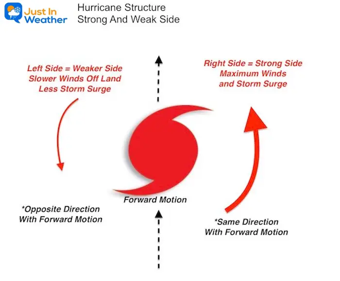
With respect to forward motions, the RIGHT (East in this case) has the winds and water moving with the forward direction. This will bring the maximum impact to Florida. The LEFT (West in this case) side has the wind and water flow opposing the forward motion, thus contradicting itself and resulting in weaker impact.
If this makes the turn then we would see the south side being the strongest with weaker off shore flow to the north. That could be helpful for Tampa if the track holds.
Ian is expected to produce the following rainfall through Thursday night:
* Western Cuba: 6 to 12 inches, with isolated totals up to 16 inches. These rains may produce flash flooding and mudslides in areas of higher terrain over western Cuba.
* Florida Keys and South Florida: 4 to 6 inches, with isolated totals up to 8 inches.
* Central West Florida: 12 to 16 inches, with isolated totals up to 24 inches.
* Northeast Florida and the remainder of the Central Florida Peninsula: 5 to 10 inches, with isolated totals up to 12 inches.
* Heavy rainfall is expected to affect the southeastern United States Friday and Saturday.
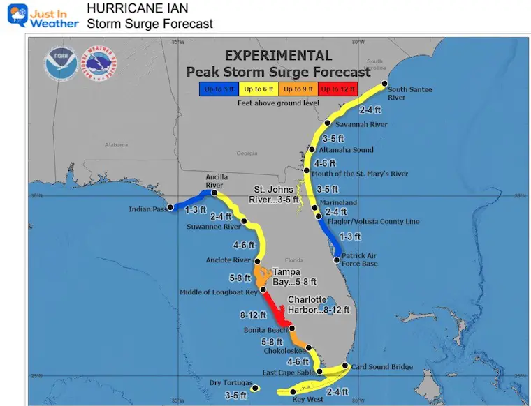
The combination of storm surge and the tide will cause normally dry areas near the coast to be flooded by rising waters moving inland from the shoreline. The wa er could reach the following heights above ground somewhere in the indicated areas if the peak surge occurs at the time of high tide…
* Middle of Longboat Key to Bonita Beach, including Charlotte Harbor…8-12 ft
* Bonita Beach to Chokoloskee…5-8 ft
* Anclote River to Middle of Longboat Key, including Tampa Bay…5-8 ft
* Suwannee River to Anclote River…4-6 ft
* Mouth of the St. Mary’s River to Altamaha Sound…4-6 ft
* Chokoloskee to East Cape Sable…4-6 ft
* Dry Tortugas…3-5 ft
* Marineland to Mouth of the St. Mary’s River, including St. Johns River…3-5 ft
* Altamaha Sound to Savannah River…3-5 ft
* St. Johns River south of Julington…2-4 ft
* Savannah River to South Santee River…2-4 ft
* Flagler/Volusia County Line to Marineland…2-4 ft
* East Cape Sable to Card Sound Bridge…2-4 ft
* Aucilla River to Suwannee River…2-4 ft
* Patrick Air Force Base to Flagler/Volusia County Line…1-3 ft
* Indian Pass to Aucilla River…1-3 ft
Hurricane Ian May Help Cooler Pattern Change: Monitor For Atmospheric Memory This Winter
If you want a snowy winter, this is what you might want to look for in the rest of the tropical season.
Record August For No Named Tropical Storms: Closer Look At Snow Following
NOAA 2022 Hurricane Forecast- Above Normal Again

NOAA Study: Reducing Air Pollution INCREASED Tropical Storms

Atlantic Tropical History: Maps of Origin Regions Every 10 Days


Click to see more and ‘Book’ a visit to your school
