


Average Last Frost or Freeze Dates And Map For Maryland
There is a good reason why many gardeners suggest NOT to plan tomatoes until after Mother’s Day. Early surges of warm air in spring can be deceiving. Just because the…
Wednesday, September 7, 2022
Afternoon Update
After a full month with no named storms, less than a week into September has produced 2 hurricanes in the Atlantic. If you missed my prior report, we have been tracking and expecting this. The other thing that has been expected in this rare pattern is a major hurricane. We are likely to have that this week.
The other two years on record with no named tropical storms in August were 1961 and 1997. Both of those years had a tropical storm form either on the 2nd or 3rd of September, which later became a Major Hurricane. That is a Category 3 with winds of 111 mph or higher.
Here we are with Danielle who formed on the 2nd, and Earl which formed on the 3rd of this month. Both are now hurricanes but heading in different directions. Literally and physically. Below is a look at the forecast maps and LIVE WEATHER WIDGET for Bermuda.
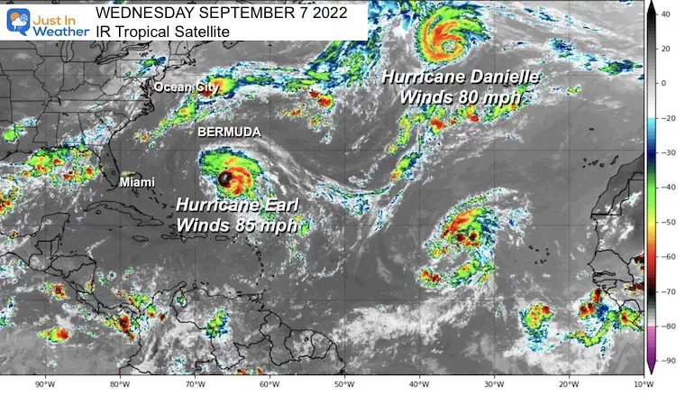
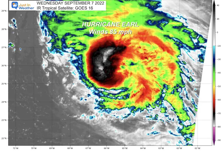
I want to start with Earl since it is the one expected to become a stronger storm AND pass close to Bermuda. A Tropical Storm Warning is in place for the island, but could expand to a Hurricane Watch depending on small adjustments to the track.
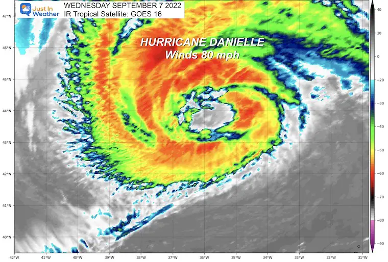
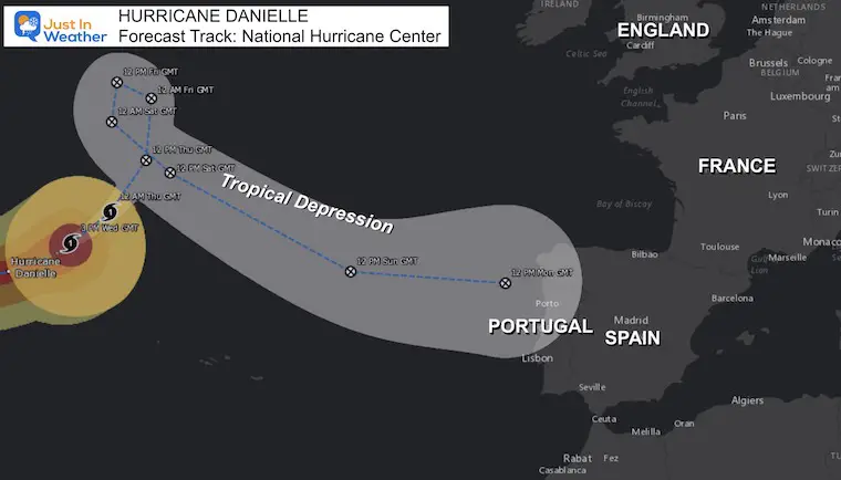
Below we can look at Hurricane Danielle, which should lose intensity as it heads towards Europe. Portugal to be more precise.
The dark red and white shading shows deep convection. These are tall cloud tops that should wrap around the center circulation and lead to rapid development over the next 24 hours.
Hurricane Force Winds extend 40 MILES FROM THE CENTER
Tropical Storm Force Winds extend 140 MILES FROM THE CENTER
AST = Atlantic Standard Time. This is 1 hour ahead of The Eastern Time Zone
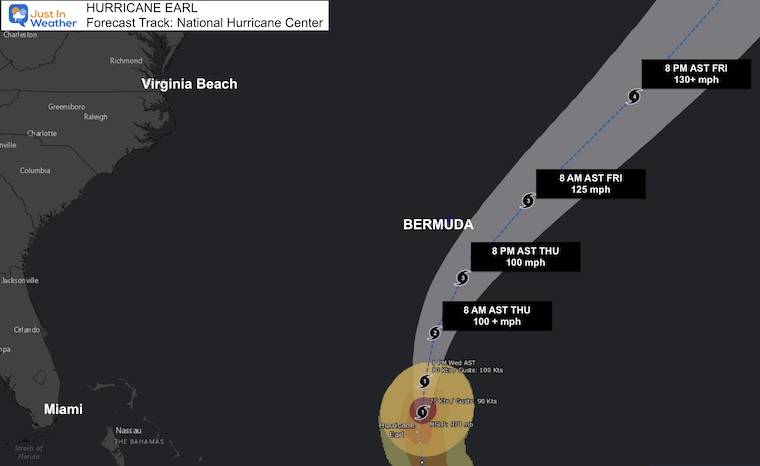
…EARL FORECAST TO BECOME A MAJOR HURRICANE LATER THIS WEEK…
…DANGEROUS SURF AND RIP CURRENT CONDITIONS EXPECTED OVER THE
EASTERN US COASTLINE FOR THE NEXT FEW DAYS…
SUMMARY OF 1100 AM AST…1500 UTC…INFORMATION
———————————————–
LOCATION…25.7N 65.7W
ABOUT 460 MI…740 KM S OF BERMUDA
MAXIMUM SUSTAINED WINDS…85 MPH…140 KM/H
PRESENT MOVEMENT…N OR 5 DEGREES AT 8 MPH…13 KM/H
MINIMUM CENTRAL PRESSURE…978 MB…28.88 INCHES
WIND:  Tropical storm conditions are expected on Bermuda beginning
Thursday afternoon.

RAINFALL:  Earl is expected to produce rainfall amounts of 1 to 2
inches (25 to 50 mm) across Bermuda through Friday.

SURF:  Swells generated by Earl are expected to reach Bermuda by
tonight and the U.S. east coast shortly thereafter. These swells are
likely to cause life-threatening surf and rip current conditions
through the weekend.  Please consult products from your local
weather office.
Almost all of the computer model guidance has this becoming a Category 3 storm by Thursday. That will carry sustained winds of 100 knots or 111+ mph. This is also when it is expected affect and then pass just east of Bermuda on Friday.
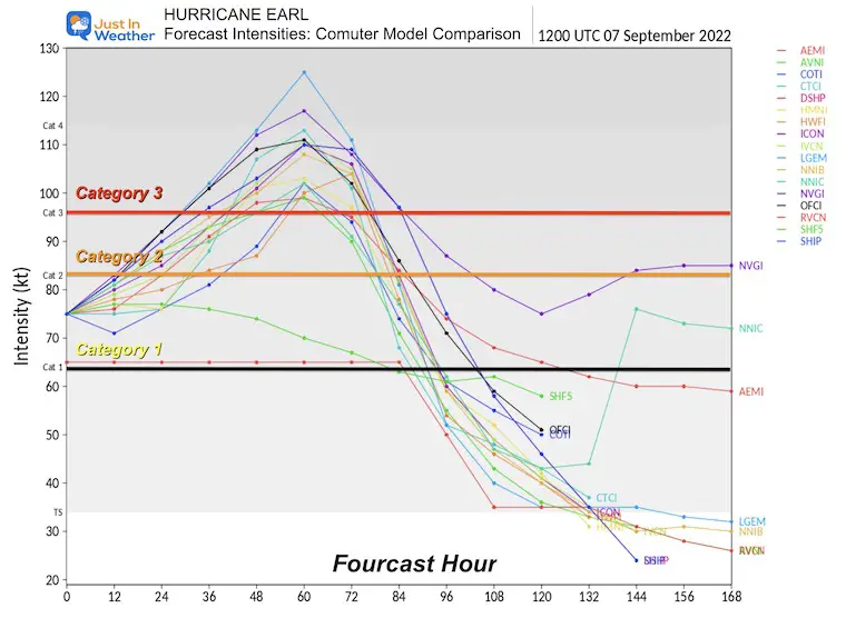
If you have family cruise, or vacation plans then Thursday and Friday will be the worst days. However, high seas are already a factor and will linger for a few days after.
I’ve placed the wind and local forecast for Hamilton. Bermuda. You can play the slider or switch to radar. This will remain Live and interactive.
This is a LARGE storm:
Hurricane Force Winds extend 70 MILES FROM THE CENTER
Tropical Storm Force Winds extend 230 MILES FROM THE CENTER
AST = Atlantic Standard Time. This is 1 hour ahead of The Eastern Time Zone
…DANIELLE REMAINS A LARGE HURRICANE OVER THE FAR NORTH ATLANTIC…
SUMMARY OF 300 PM GMT…1500 UTC…INFORMATION
———————————————-
LOCATION…43.7N 36.3W
ABOUT 625 MI…1005 KM NW OF THE AZORES
MAXIMUM SUSTAINED WINDS…80 MPH…130 KM/H
PRESENT MOVEMENT…NE OR 55 DEGREES AT 16 MPH…26 KM/H
MINIMUM CENTRAL PRESSURE…972 MB…28.71 INCHES
As this enters the colder waters of the North Atlantic, it is inevitable that this storm will weaken and get downgraded to a post tropical or tropical depression. The remnant Low should reach Portugal by Monday next week.
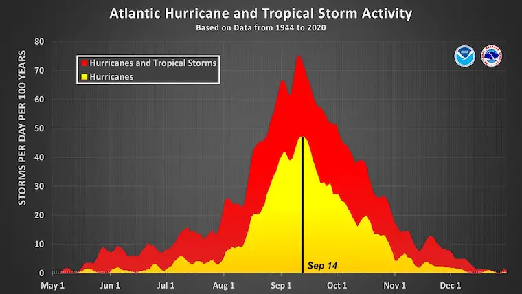
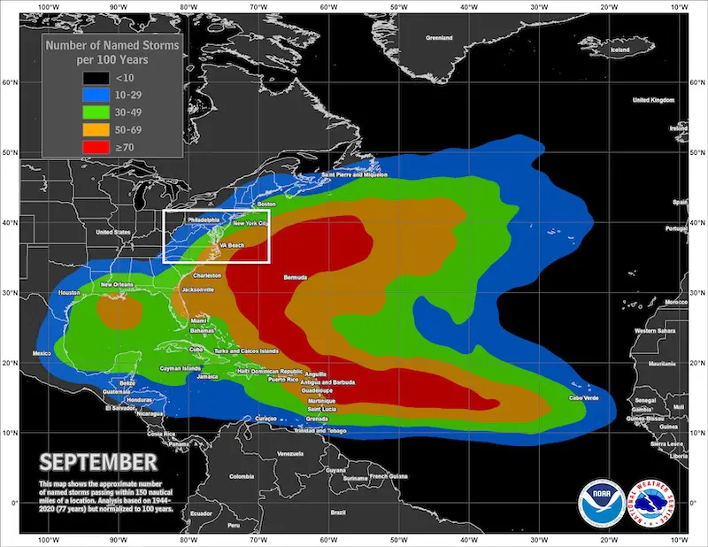
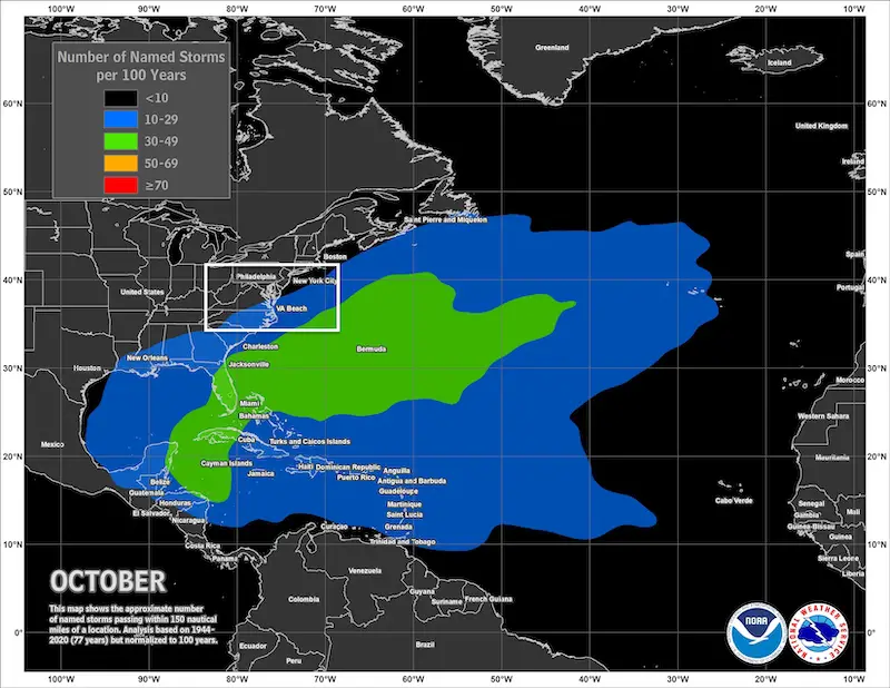
Historic Climate Data shows the most active time for the Atlantic is still a few weeks away.
Record August and Snow
COMPARE TO THE PAST
If you want a snowy winter, this is why you might want to look for in the rest of the tropical season.
Record August For No Named Tropical Storms: Closer Look At Snow Following
NOAA Study: Reducing Air Pollution INCREASED Tropical Storms

Atlantic Tropical History: Maps of Origin Regions Every 10 Days


NOAA 2022 Hurricane Forecast- Above Normal Again


Click to see more and ‘Book’ a visit to your school

Rainbow Ice Cave In Mt. Rainier A Very Rare Find: Photos And Video
Need a home improvement contractor?