Tuesday Afternoon Storm Update: Simulation And Live Radar
August 30 2022
Tuesday Afternoon Update
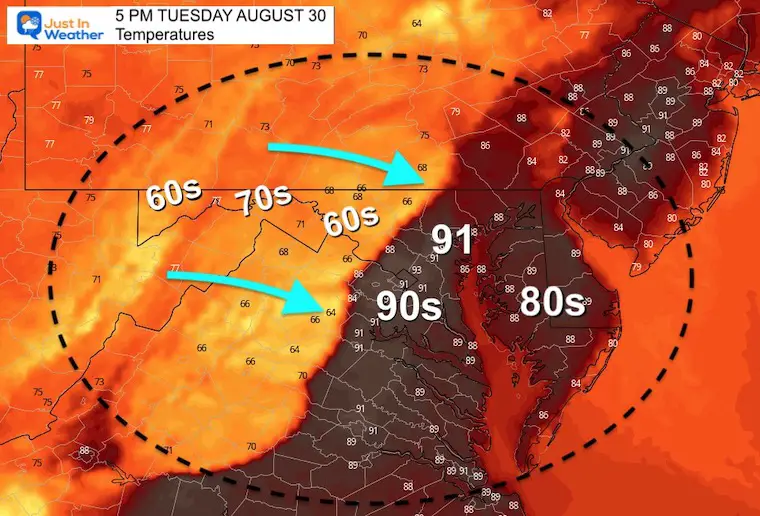
The cold front is approaching and already reaching the Maryland mountains. The result of the initial wave of rain has dropped temps into the 60s, contrasted with the 90s around metro Baltimore and Washington DC.
We expect this line of storms to develop over the next few hours, then head east into central Maryland, southern Pennsylvania, and metro Washington to Annapolis. The push of rain will likely be 30 to 60 minutes long for most, but will vary depending on the integrity of the squall line.
Regardless of reaching severe levels or not, any storm is capable of producing dangerous lightning. See the live Lightning and Radar Widget below.
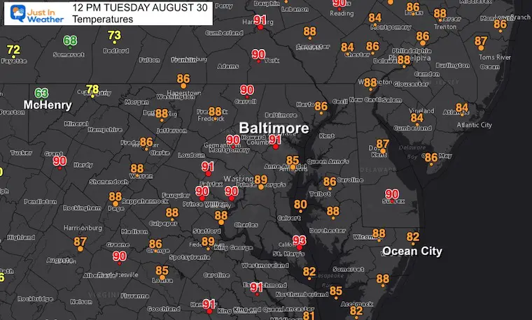
Temperatures At Noon
Check out the 60s in McHenry to upper 80s and lower 90s around Baltimore, Washington, and much of central Maryland to Delmarva.
Temperature Forecast at 5 PM
This gives us a good idea that the boundary should pass between Frederick and Baltimore between 4 PM and 6 PM.
The line of storms is expected to push through late afternoon and early evening, clashing these air masses, and it is possible some urban areas will get that dramatic temperature drop with the cold front… which may be lined up with your commute or after school sports.
LIVE LIGHTNING and RADAR WIDGET
Radar Simulation Forecast
Comparing Two Models
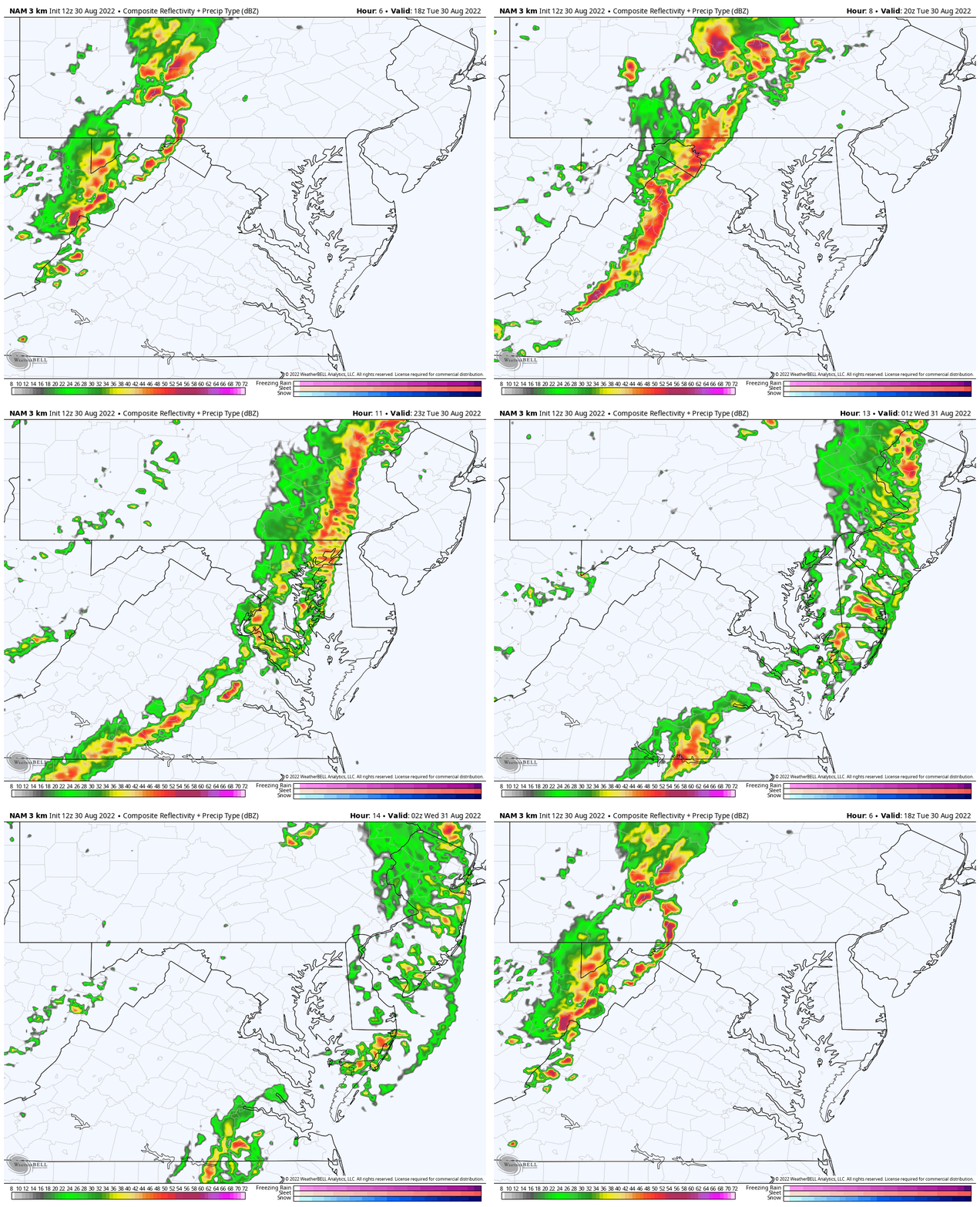
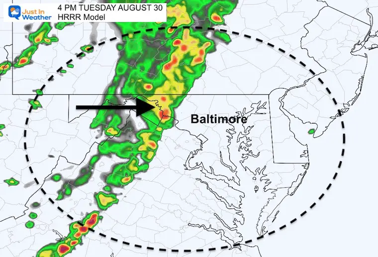
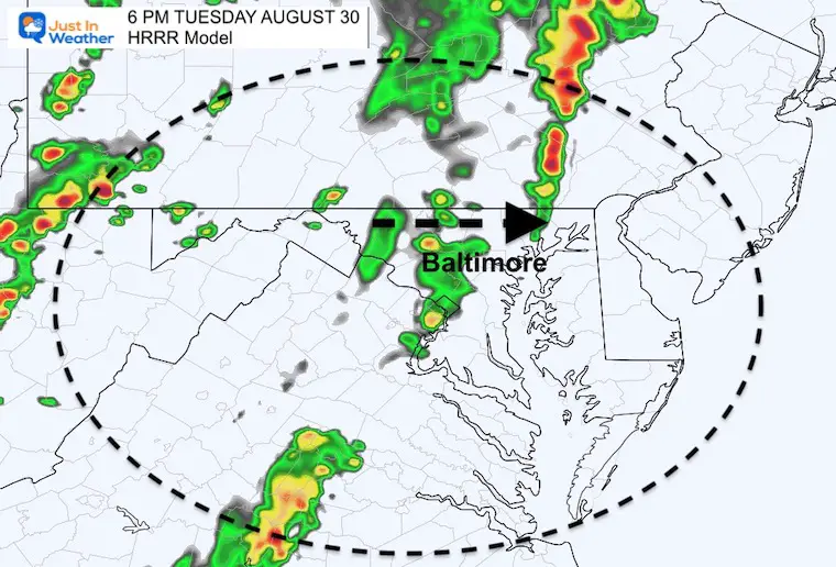
The good news is that the timing does appear to be in agreement with passage through metro Baltimore around 6 PM on both the NAM 3 Km and HRRR.
I should reiterate that we have seen weather events arrive as much as 1 to 2 hours faster all summer. So I would still add the caveat of at least a 1 hour buffer to the model plots below.
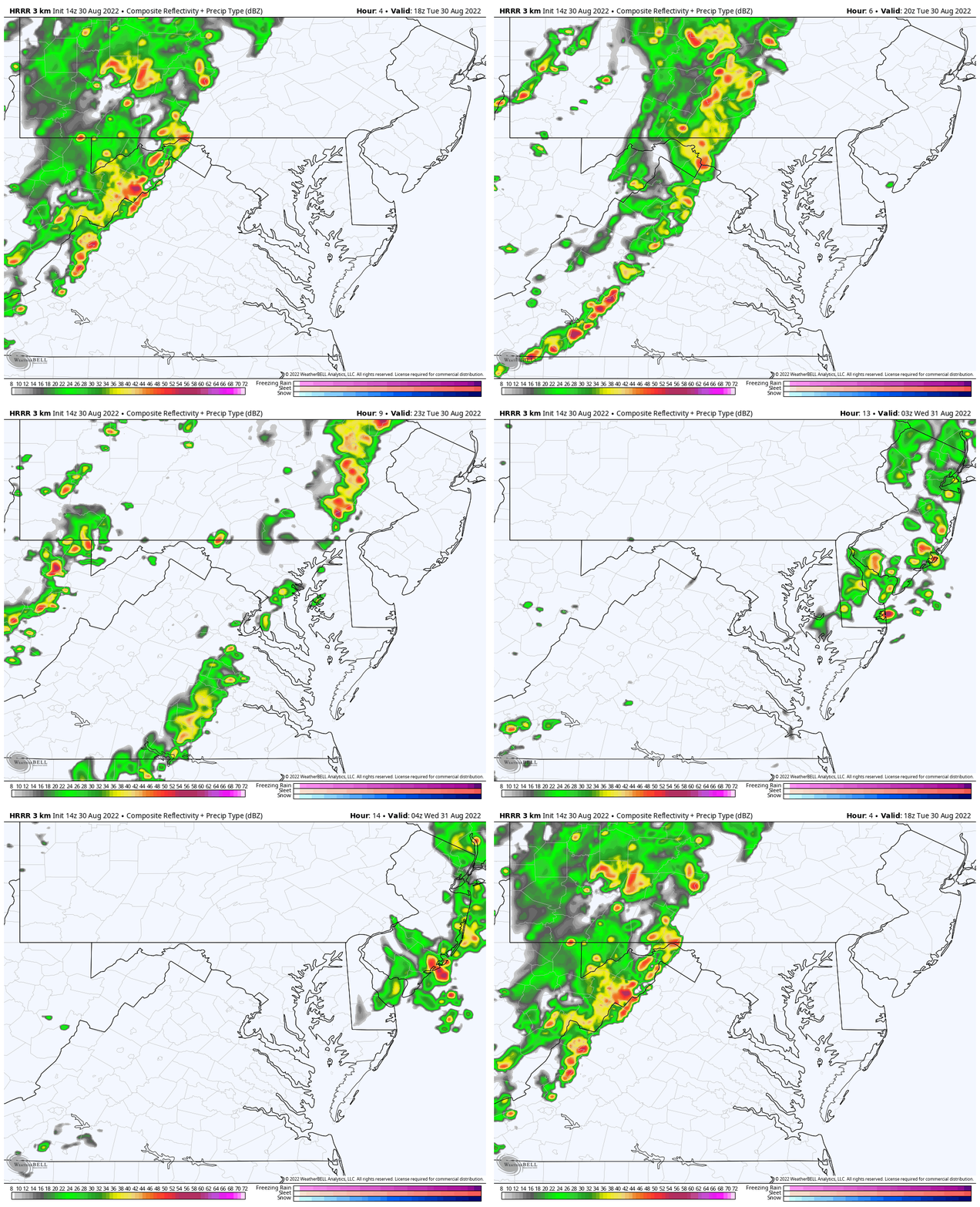
The contrast or split is THE SPLIT. The NAM does weaken the line east of the mountains, but still shows a potent squall line move through the region. The HRRR Model breaks up the line, which could leave some wondering ‘where is it’?
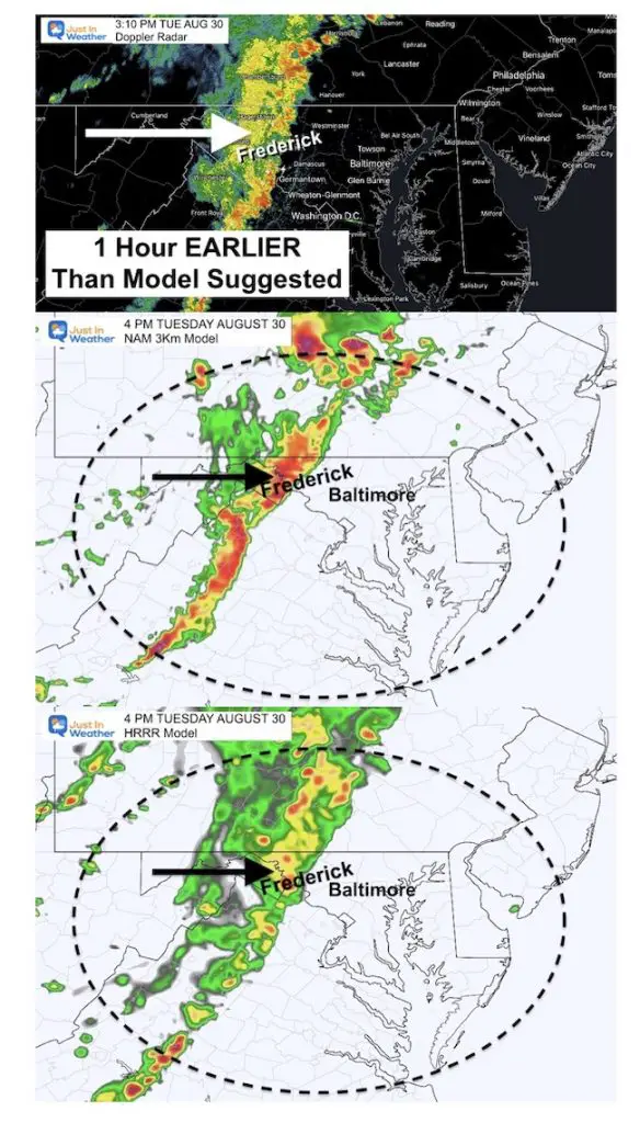
UPDATE FROM 3 PM RADAR
- 1 Hour EARLIER than models suggested.
- 3 PM Radar Comparison:
- If you saw my report this afternoon, I mentioned the was possible.
- Storms Reaching Frederick at 3 PM, means they should reach metro Baltimore by 5 PM
UPDATE FROM 4:30 PM Temperatures and Radar
Arriving even EARLIER than anticipated…
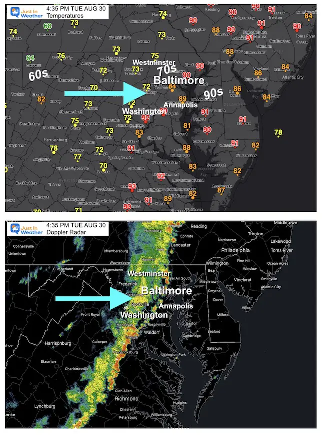
Check this out:
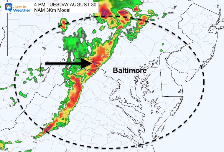
NAM 3 Km Simulation Snapshots
4 PM
The leading edge of the squall line, and perhaps severe storms cells reaching the mountains. This should include Hagerstown, Boonsboro and approaching Frederick.
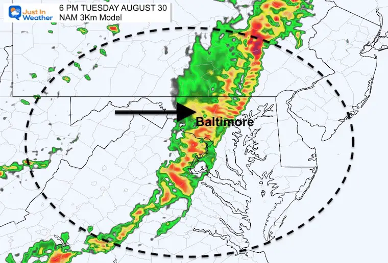
6 PM
The leading edge of the squall line, and perhaps severe storms cells reaching the Baltimore and Washington DC Beltways.
Animation 2 PM to 10 PM
This line crosses Delmarva and reaches the beaches by 10 PM
HRRR Simulation Snapshots
4 PM
The leading edge of the squall line, and perhaps severe storms cells reaching the mountains. This should include Hagerstown, Boonsboro and approaching Frederick.
6 PM
The leading edge of the squall line breaks up! Perhaps strong cells but also voids in the radar reaching around the Baltimore Beltway…
We should all still feel the gusty front with winds and falling temps.
Animation 2 PM to Midnight
This line crosses Delmarva and reaches the beaches by 10 PM
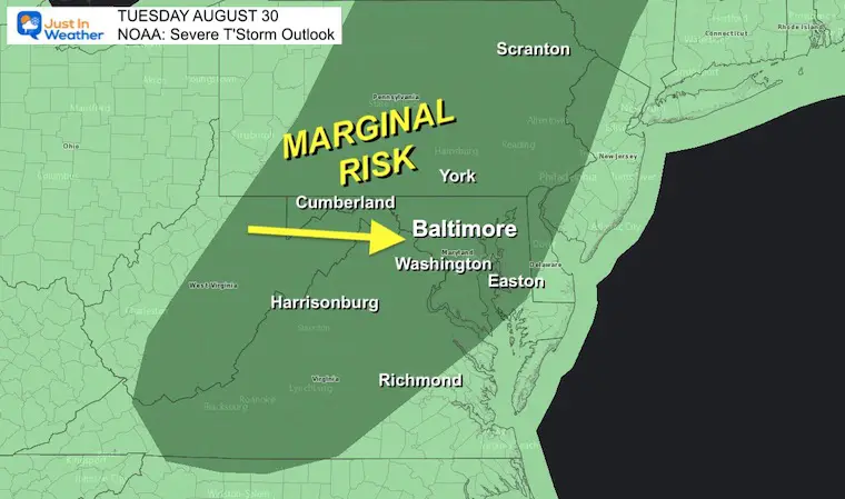
NOAA Severe Thunderstorm OUTLOOK
This suggests strong storms may still reach severe limits:
Damaging Wind
Large Hail
However it may not prompt a ‘Watch’ for the region, but individual cells could fall under those criteria.
Weather posts straight to your inbox
Sign up and be the first to know!
You Might Also Like
Snowfall For Winters Following Very Quiet Tropical Seasons
Tropics Waking Up In Atlantic But Still Going For August Record
Hurricane Season Forecast: June 1 Through November 30
NOAA 2022 Hurricane Forecast- Above Normal Again
Forecast From Colorado State University
Related Posts
NOAA Study: Reducing Air Pollution INCREASED Tropical Storms
Atlantic Tropical History: Maps of Origin Regions Every 10 Days
Recent Storm Reports
May 16 Large Hail Videos And Storm Tracking Map
Please share your thoughts, best weather pics/videos, or just keep in touch via social media
Facebook: Justin Berk, Meteorologist
Twitter: @JustinWeather
Instagram: justinweather
Cancer Can Succit- THE SHIRT
By Popular Demand and Supporting Just In Power Kids
This is the shirt that Power Kid James and his family has embraced… They even surprised us with this sign during our Kids Trek Too event.
It is now available!
Connect With A Health Coach
From My Maryland Trek Team
Click the image or here for more info
*Disclaimer due to frequent questions:
I am aware there are some spelling and grammar typos. I have made a few public statements over the years, but if you are new here you may have missed it:
I have dyslexia, and found out at my second year at Cornell. It didn’t stop me from getting my meteorology degree, and being first to get the AMS CBM in the Baltimore/Washington region.
I do miss mistakes in my own proofreading. The autocorrect spell check on my computer sometimes does an injustice to make it worse.
All of the maps and information are accurate. The ‘wordy’ stuff can get sticky.
There is no editor that can check my work when I need it and have it ready to send out in a newsworthy timeline.
I accept this and perhaps proves what you read is really from me…
It’s part of my charm.


