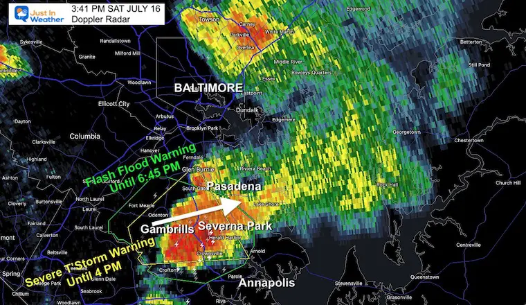
3:45 PM Saturday July 16
Another Severe Thunderstorm Warning on the tail end of the line we’ve been following is impacting central Maryland south of Baltimore. This was issued for Anne Arundel County until 4 PM. However in addition there has been a Flash Flood Warning. That is due to the heavy rain and noted rising water!
I have included the Live Doppler Radar and Lightning Widget below
Warning Map
Note: See the live radar widget below as the rain is expanding south and will impact Annapolis by 4 PM!
Official National Weather Service Report
Severe Thunderstorm Warning Until 4 PM
Flash Flood Warning Until 645 PM.
* At 333 PM EDT, Doppler radar indicated thunderstorms producing
heavy rain across the warned area. Between 1.5 and 2 inches of
rain have fallen. Additional rainfall amounts of 1 to 2 inches are
possible in the warned area. Flash flooding is ongoing or expected
to begin shortly.
HAZARD…Flash flooding caused by thunderstorms.
SOURCE…Radar.
IMPACT…Flash flooding of small creeks and streams, urban
areas, highways, streets and underpasses as well as
other poor drainage and low-lying areas.
* Some locations that will experience flash flooding include…
- Bowie… Severn…
- Crofton… Glen Burnie…
- Severna Park… Odenton…
- Pasadena… Arnold…
- Lake Shore… Parole…
- Fort Meade… Millersville…
- South Gate… Gambrills…
- Herald Harbor… Crownsville…
- Sherwood Forest…
This includes the following Flood Prone Roads:
MD 450 from St Stephens Church Rd to Huntwood Dr…
PRECAUTIONARY/PREPAREDNESS ACTIONS…
Turn around, don’t drown when encountering flooded roads. Most flood
deaths occur in vehicles.
LIVE RADAR/LIGHTNING WIDGET
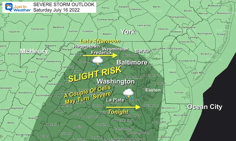
Severe Storm Risk
This is the NOAA Outlook, which has our region as ‘Slight Risk’. This is the lowest level of awareness, 1 out of 5. For comparison, the Tuesday outlook was level 3.
Out of all the storms, perhaps 15% could turn severe with damaging winds or large hail).
Storm Reports (preliminary) : Tuesday July 12
July 12 Severe Storm Radar Scans: Was There A Tornado Or Not?
July 12 Storm Reports Pics And Videos
Looking Ahead:
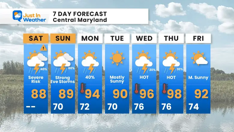
7 Day Forecast
More storms likely Sunday Evening could turn severe!
Then we watch for high heat and a true heat wave (rare this summer) during the week.
Plan Your Kayaking Day Now

Hurricane Season Forecast: June 1 Through November 30
NOAA 2022 Hurricane Forecast- Above Normal Again

Forecast From Colorado State University
Atlantic Hurricane Forecast

Related Posts
NOAA Study: Reducing Air Pollution INCREASED Tropical Storms

Atlantic Tropical History: Maps of Origin Regions Every 10 Days


Recent Storm Reports
May 22 Hail And Wind Damage

May 16 Large Hail Videos And Storm Tracking Map


Please share your thoughts, best weather pics/video, or just keep in touch via social media
*Disclaimer due to frequent questions:
I am aware there are some spelling and grammar typos. I have made a few public statements over the years, but if you are new here you may have missed it:
I have dyslexia, and found out at my second year at Cornell. I didn’t stop me from getting my meteorology degree, and being first to get the AMS CBM in the Baltimore/Washington region.
I do miss my mistakes in my own proofreading. The autocorrect spell check on my computer sometimes does an injustice to make it worse.
All of the maps and information are accurate. The ‘wordy’ stuff can get sticky.
There is no editor that can check my work when I need it and have it ready to send out in a newsworthy timeline.
I accept this and perhaps proves what you read is really from me…
It’s part of my charm.


