


May 17 Clouding Up Ahead Of A Soggy Preakness Saturday Then We Warm Up
Friday May 17 Morning Report Today may end up mild, but it will bring an increase in clouds ahead of our next storm. If you are heading to the mountains,…
July 12 2022
Tuesday Late Morning Update
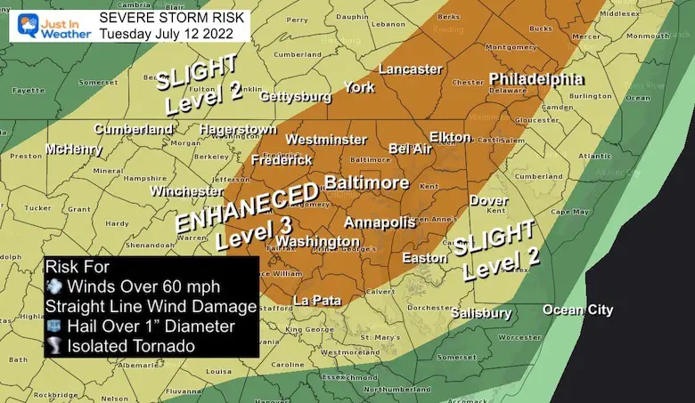
When combining the high heat, humidity, and timing the cold front today the conditions support a higher chance for severe weather. This has prompted NOAA to upgrade our region to Enhanced Risk.
This means that more storms are likely to produce wind damage. This could be microbursts or straight line winds. In addition, more storm may have large hail over 1 inch diameter, and rotating supercells to produce tornados.
Here is a break down of the risk assessment maps and new radar simulations plus live radar widget.
The NOAA outlook has focused the Enhanced Risk for severe storms to include metropolitan Washington, Baltimore, York/Lancaster, and Philadelphia
Potential for damming wind, large hail, and an isolated tornado. Any storm may also produce flooding and dangerous lighting.
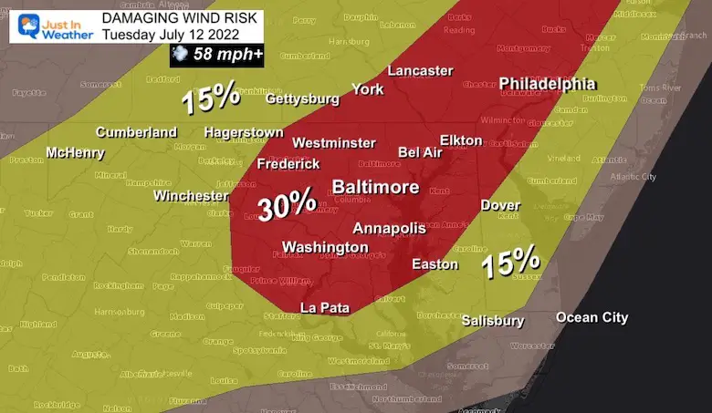
There is a 30% chance of storms in this (red) region to produce winds in excess of 58 mph. This may be microbursts or straight line wind damage without a tornado. That can take down trees, power lines, and move lawn furniture.
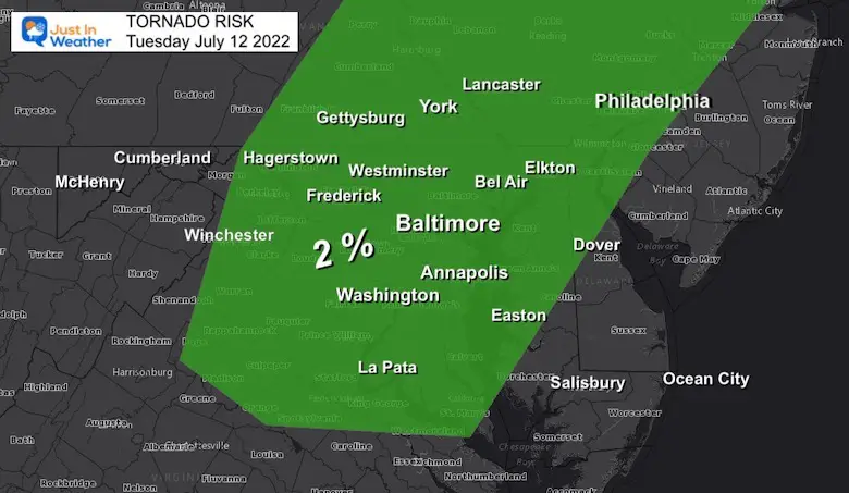
This is important to note: 2% of the storms may produce a tornado. Not all rotation will produce a funnel cloud touching the ground.
Watch: This will be issued when the potential development for a large areas over a 6 hour time frame.
Warning: This will be issued when a storm is happening and being tracked through specific towns. That may cover a 30 to 45 minute time frame.
Rainfall rates may reach 1 to 2 inches per hour.
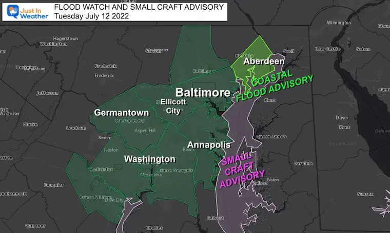
Small Craft Advisory for winds ups to 20 knots on The Chesapeake Bay.
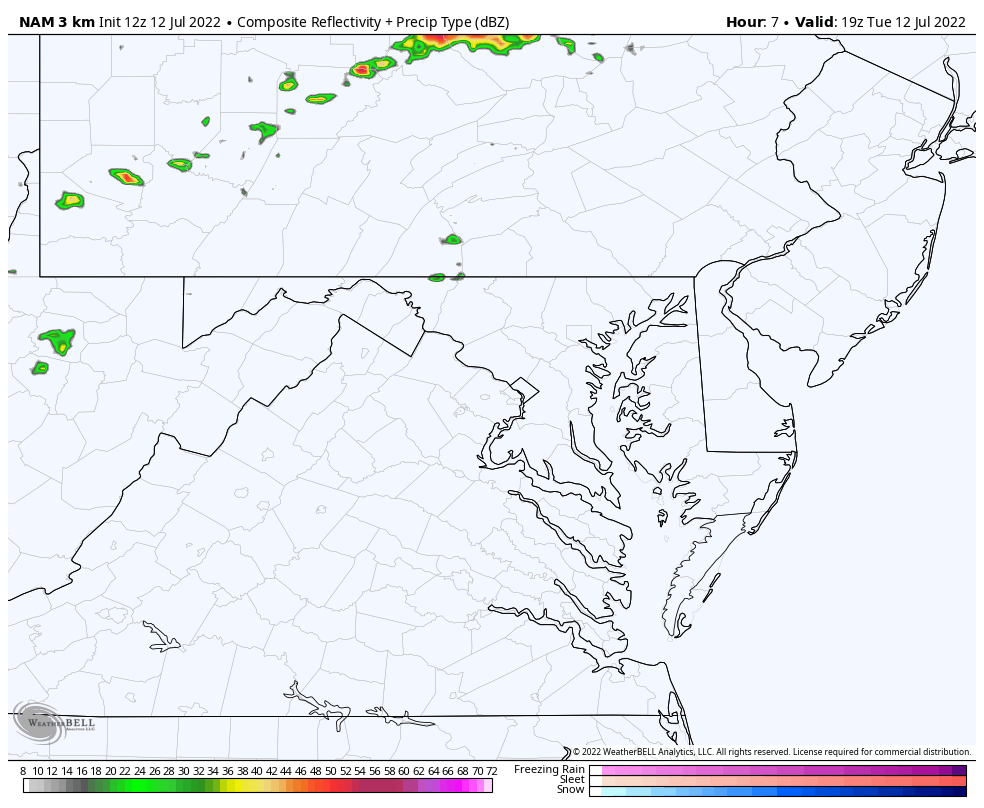
HRRR Model
This is a suggestion and not perfect. Please consider a buffer of at least 1 hour AND we have seen recent events more active than forecasted.


The peak timing of storms:
HRRR 2 PM to Midnight
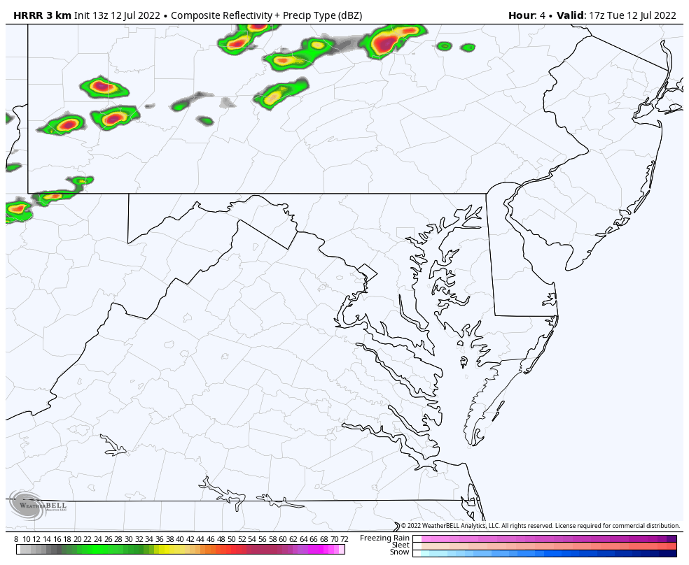
This solution contrast has a big void in the severe storm line crossing central Maryland.
It is also later, with metro Washington AND Northeastern Maryland (Harford and Cecil Counties) getting the storms between 8 PM and 10 PM
All alerts will display in a banner on the top of the website. However, you can also go to this page and refresh for the complete NWS Alerts information as they are posted.
https://justinweather.com/alert_categories/nws-alert/

NOAA 2022 Hurricane Forecast- Above Normal Again


NOAA Study: Reducing Air Pollution INCREASED Tropical Storms

Atlantic Tropical History: Maps of Origin Regions Every 10 Days


May 16 Large Hail Videos And Storm Tracking Map


*Disclaimer due to frequent questions:
I am aware there are some spelling and grammar typos. I have made a few public statements over the years, but if you are new here you may have missed it:
I have dyslexia, and found out at my second year at Cornell. I didn’t stop me from getting my meteorology degree, and being first to get the AMS CBM in the Baltimore/Washington region.
I do miss my mistakes in my own proofreading. The autocorrect spell check on my computer sometimes does an injustice to make it worse.
All of the maps and information are accurate. The ‘wordy’ stuff can get sticky.
There is no editor that can check my work when I need it and have it ready to send out in a newsworthy timeline.
I accept this and perhaps proves what you read is really from me…
It’s part of my charm.