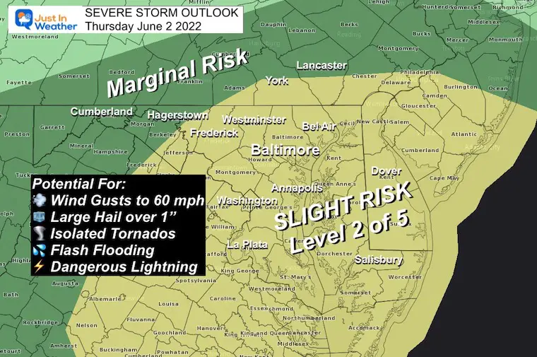
We has a Slight Risk for severe storms to develop this afternoon and evening. This is the first phase of any alerts we may receive as the day continues. This means the atmosphere is primed to produce storms that may reach severe limits.
Sever Storms are classified as:
Winds over 58 mph
Hail over 1” diameter
Flash Flooding
Isolated Tornados
Dangerous Lightning
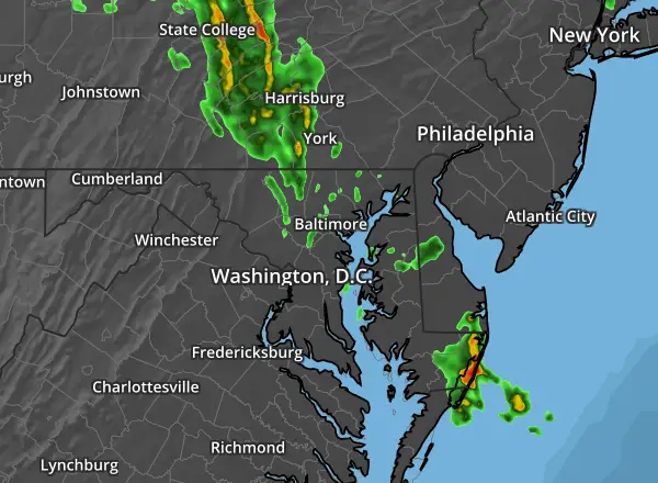
NOAA Severe Storm Risk Today
Alert Reminder
A Watch means it ‘might’ happen.
A WARNING means it is ‘HAPPENING NOW’. This is more urgent and tracking an event across towns with more specific times.
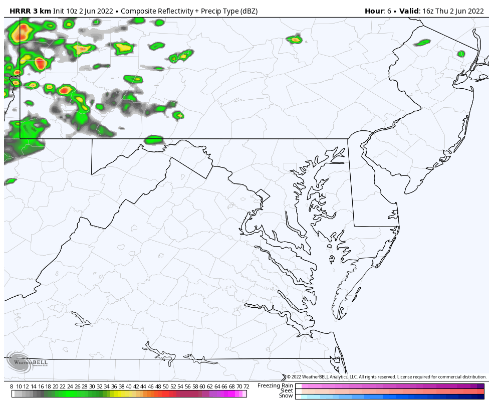
NEW RADAR SIMULATION
The HRRR Model (High Resolution Rapid Refresh) updates every hour based off of the latest conditions applied to the main model output, which is every 6 hours.
This is NOT perfect, but does give an indication of general location and timing of storm clusters.
Here we see the first round in Southern Pennsylvania early in the afternoon…
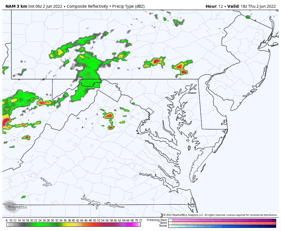
Then the focus will shift to metro Baltimore and Southern Maryland AFTER 4 PM. The activity should settle down around and after sunset.
Slider —-> 2 PM to 10 PM
june-2-weather-storm-radar-thursday-hrrr-pm-2
june-2-weather-storm-radar-thursday-hrrr-pm-3
june-2-weather-storm-radar-thursday-hrrr-pm-4
june-2-weather-storm-radar-thursday-hrrr-pm-5
june-2-weather-storm-radar-thursday-hrrr-pm-6
june-2-weather-storm-radar-thursday-hrrr-pm-7
june-2-weather-storm-radar-thursday-hrrr-pm-8
june-2-weather-storm-radar-thursday-hrrr-pm-9
june-2-weather-storm-radar-thursday-hrrr-pm-10
june-2-weather-storm-radar-thursday-hrrr-pm-11
june-2-weather-storm-radar-friday-hrrr-am-12
Animation HRRR Model: Noon to Midnight
Compare to this morning’s NAM 3 KM Model.
Animation NAM 3 Km Model
There are subtle differences
Compare To The 2 Hour Radar Loop
Showing Last 2 Radar map data
Last 2
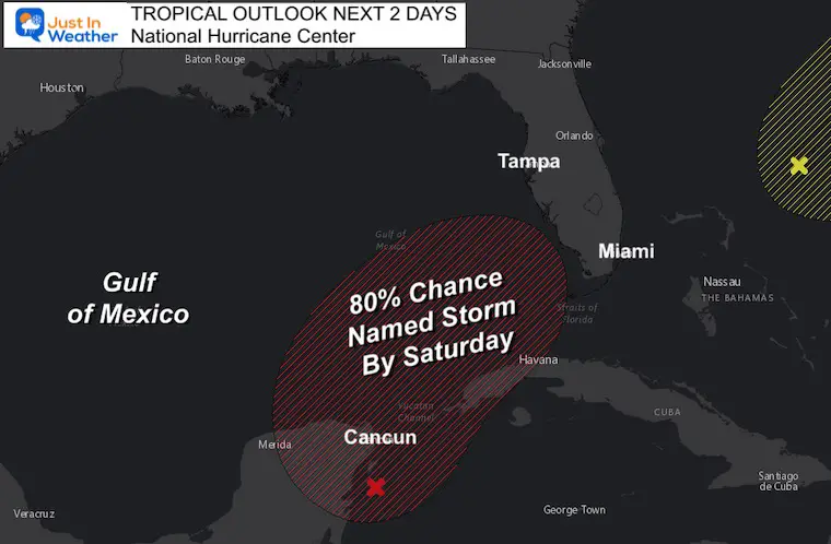
Tropical Outlook
NOAA and The National Hurricane Center gives a 80% chance for a named storm by Saturday. It will be called Alex.
Heavy rain will cross Florida and may clip North Carolina, but not reach us.However, the high surf could ripple up through our local beaches later in the weekend and next week.
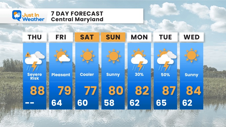
7 Day Forecast
A pleasant cool down tomorrow into the weekend.
The tropical weather will miss us, but may impact the waves on the local beaches.
I am aware there are some spelling and grammar typos. I have made a few public statements over the years, but if you are new here you may have missed it:
I have dyslexia, and found out at my second year at Cornell. I didn’t stop me from getting my meteorology degree, and being first to get the AMS CBM in the Baltimore/Washington region.
I do miss my mistakes in my own proofreading. The autocorrect spell check on my computer sometimes does an injustice to make it worse.
All of the maps and information are accurate. The ‘wordy’ stuff can get sticky.
There is no editor that can check my work when I need it and have it ready to send out in a newsworthy timeline.
I accept this and perhaps proves what you read is really from me…