March 4 2022
Friday Afternoon Update
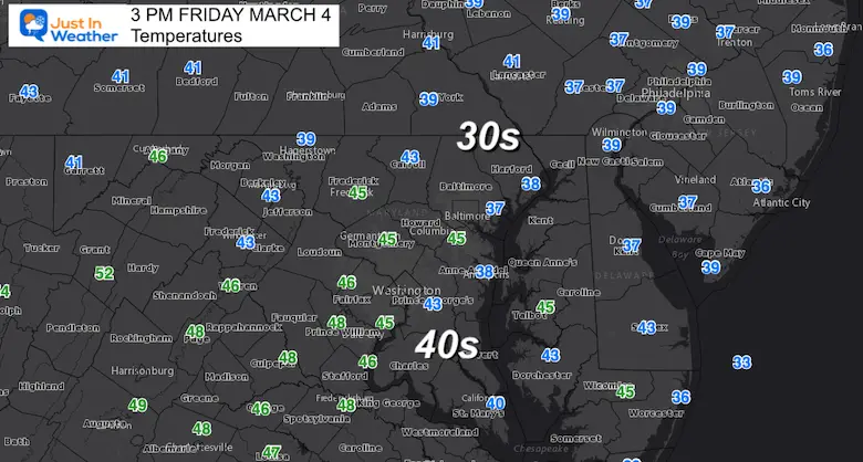
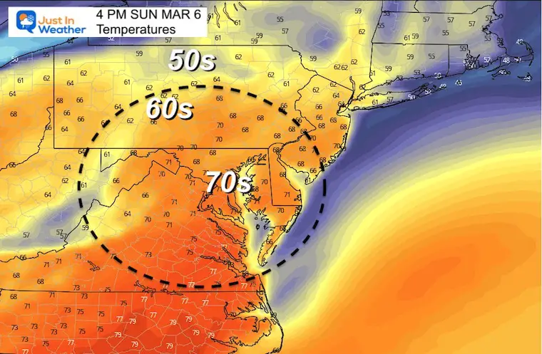
I am writing this on a day when temperatures are chilly, but a jump of 30 degrees is expected in a few days. Taking a look at the observations at 3 PM and we see upper 30s to mid 40s. By Sunday and Monday most of these weather stations will be reading the 70s.
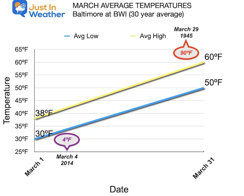
March is a month that trends warmer with wild swings along the way. For example, Baltimore’s BWI usually begins the month with afternoons around 50ºF and ends the month around 60ºF.
Jet Stream Flip
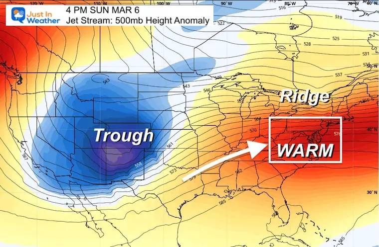
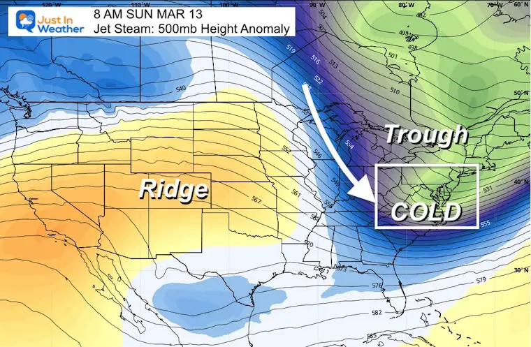
The driving forecast behind our weather patterns, and more directly the source of air masses is the jet stream. Compare the reversal of fortune for the Eastern US from this Sunday March 6 to next Sunday March 13.
See The Still Snapshots Below

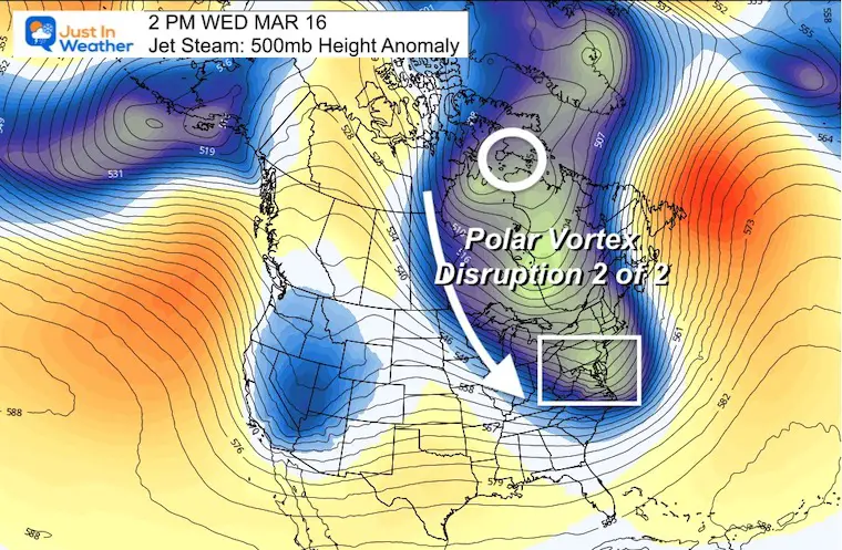
The Ridge in the eastern US this weekend will allow warmer air to flow in for a few days. This should peak on Monday with a possible new record high. But next weekend, the Trough will be the result of the Polar Vortex being disrupted and allowing cross polar flow to drop south and bring us colder weather than we see now.
Sunday March 6
Jet Stream
Temperatures (Afternoon High)
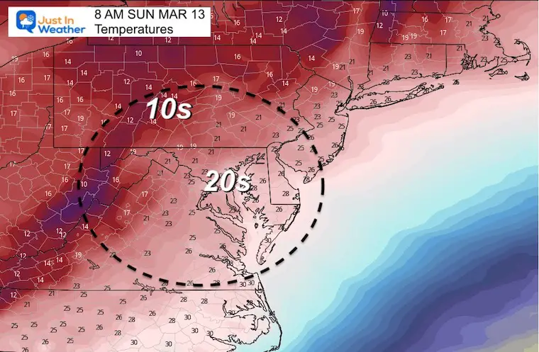
Sunday March 13
Jet Stream
Temperatures (Morning Low)
Winter Not Done But Does NOT Promise A Winter Storm
Here is a look at the storm track during this transition. There is some snow seen to our north, but not for our region.
The modeling has not been reliable for surface storms in the long range all winter. So while there is nothing of substance seen here now, it still may produce something during the transition.
GFS Model: Thu Mar 10 to Sat Mar 12
When The Polar Vortex is mentioned, it brings up notations of very cold air. I believe it was 2014 when this reached pop culture as we had it nearly reach the northern US un January and March. In fact it was on this date, March 4, 2014 when BWI dropped to 4ºF in the morning to mark the coldest temperature on record for the month in Baltimore.
The next mention of ‘The Polar Vortex’ may not be as extreme, but it will keep the risk of winter weather around.
I am NOT the only talking about this. Let’s refer back to the great Dr Judah Cohen for two recent tweets on the topic.
So yes, he is keeping snow chances up AFTER the initial surge of cold air next weekend… In fact, it now appears there will be TWO impulses from the Polar Vortex.
Let’s take a look at the Broad Picture
10 Day Animation
Sun Mar 6 to Wed Mar 16
Polar Vortex Disruption 1

Polar Vortex Disruption 2
Forecast Temperatures (through next weekend)
Take Away: Don’t let your guard down
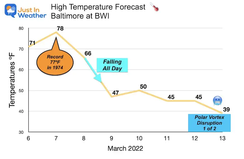
It will get warm this weekend. We may get a new record high on Monday, only to see the the bottom fall out at the end of the week.
A high of 39ºF for Baltimore may not sound impressive, but that would translate to near freezing for the inland suburbs.
Can it snow?
Yes! However, we would need something special for it to be a legit impactful storm. Most of the time in March, we need an event to begin or mostly fall at night to allow stickage. Then again, March 12 to 14 in 1993 was the famed SuperStorm event that produced about a foot of snow with heavy icing on Baltimore, and three feet of snow inland.
Anything is possible… Especially with a high amplitude pattern like this.
So, no promises, but if you have Faith in the Flakes it will be an interesting week or two to watch.
ALSO SEE
ALL FITF GEAR

FITF THUNDERSNOW


Winter Outlook Series:
My Call For Snowfall

Last Winter Recap: My Old Outlook And Your Grades Of My Storm Forecasts


Please share your thoughts, best weather pics/video, or just keep in touch via social media
*Disclaimer due to frequent questions:
I am aware there are some spelling and grammar typos. I have made a few public statements over the years, but if you are new here you may have missed it:
I have dyslexia, and found out at my second year at Cornell. I didn’t stop me from getting my meteorology degree, and being first to get the AMS CBM in the Baltimore/Washington region.
I do miss my mistakes in my own proofreading. The autocorrect spell check on my computer sometimes does an injustice to make it worse.
All of the maps and information are accurate. The ‘wordy’ stuff can get sticky.
There is no editor that can check my work when I need it and have it ready to send out in a newsworthy timeline.
I accept this and perhaps proves what you read is really from me…
It’s part of my charm.
#FITF


