It is NOT yesterday, for sure.Just 24 hours ago, temperatures were about to surge from the upper 60s to mid 70s under sunshine.Now, a mix of snow or graupel, sleet, and rain is falling across our region.It will last for a few hours, but today is NOT the concern.
The next wave will develop tonight, and that is when there may be some icing. But with the warm ground, the wild card will be how much can it cool and if it can support ice on the roads.
This update will show the timeline for the precipitation and temperatures.Odds are this ends before morning and the icing will be limited to farther inland.
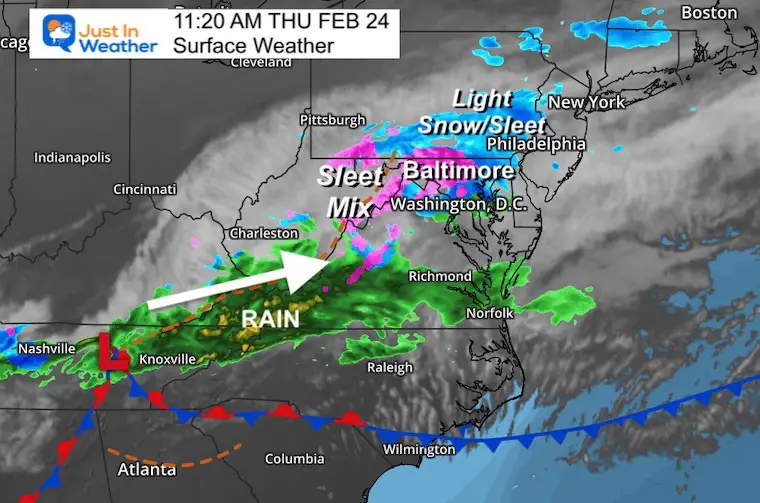
11 AM Set Up
Wave 1 of 2 in place now. The second part will arrive tonight.
Local Radar
This is a light wintry mix, and may not all be reaching the ground. Also, temps as shown below are above freeing at the surface in much o the area…
This will be cooling over the next few hours.
Temperatures
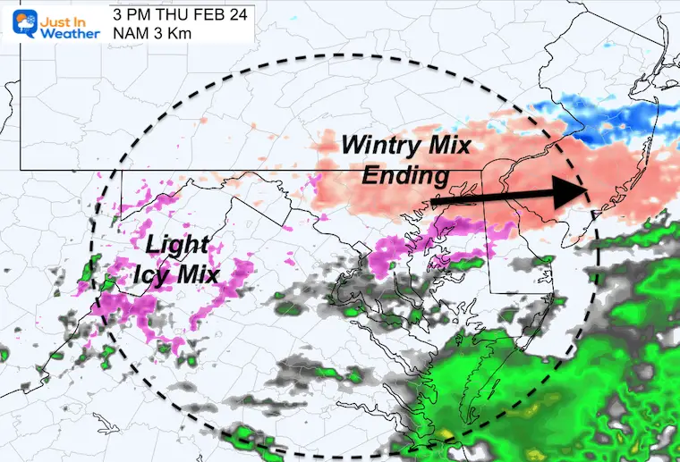
3 PM Wave 1 Ending
This is when the frost round of ‘stuff’ should be ending….
Color Code
Blue – Snow
Orange/Peach – Sleet/Mix
Pink/Purple – Freezing Rain
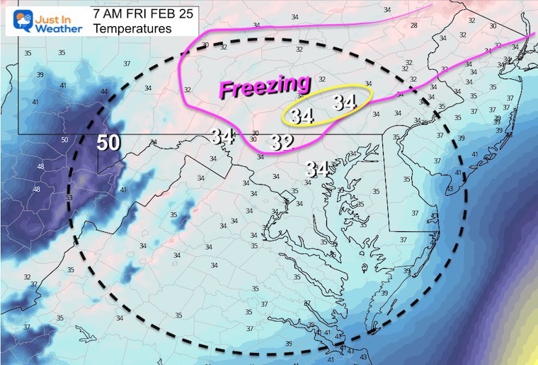
Temperatures
The freezing line should remain just west and north of Baltimore. But in daylight, the roads will still be too warm for stickage.
Wave 2 – Overnight Icing?
At this time it looks like light freezing rain or sleet will develop between 6 PM and 9 PM. Evening plans should be OK.
If there is icing, it would develop between 10 PM and 12 AM/Midnight.
Radar Simulation —-> slider
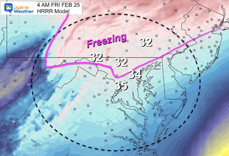
HRRR Model – This showed the end of the icing mix around 4 AM
february-24-weather-ice-radar-thursday-pm-7
february-24-weather-ice-radar-thursday-pm-8
february-24-weather-ice-radar-thursday-pm-9
february-24-weather-ice-radar-thursday-pm-10
february-24-weather-ice-radar-thursday-pm-11
february-24-weather-ice-radar-friday-am-12
february-24-weather-ice-radar-friday-am-1
february-24-weather-ice-radar-friday-am-3
february-24-weather-ice-radar-friday-am-4
NAM 3Km Simulation
7 PM THU to 10 AM FRI
This model keeps the light mix around through sunrise.
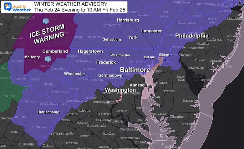
Winter Weather Advisory – Reminder
The potential for icing will be greater on elevated surfaced than the roads.
But if roads get slick, it would be farther west and north.
The chance for school delays are low, but all depends on how cold the roads can get to support icing.
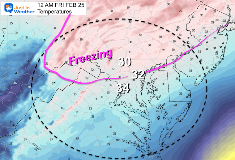
Temperatures
Midnight – 12 AM
Briefly down to near Freezing for Baltimore.
A better chance to remain the cold west and north of the city.
4 AM – When the Precinct May Be Ending
Freezing Line remaining West and North Of the City
I am aware there are some spelling and grammar typos. I have made a few public statements over the years, but if you are new here you may have missed it:
I have dyslexia, and found out at my second year at Cornell. I didn’t stop me from getting my meteorology degree, and being first to get the AMS CBM in the Baltimore/Washington region.
I do miss my mistakes in my own proofreading. The autocorrect spell check on my computer sometimes does an injustice to make it worse.
All of the maps and information are accurate. The ‘wordy’ stuff can get sticky.
There is no editor that can check my work when I need it and have it ready to send out in a newsworthy timeline.
I accept this and perhaps proves what you read is really from me…